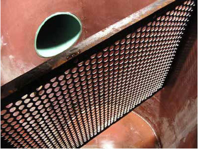
The reuse of old tires that often end up in landfills has a significant environmental benefit. Tire derived aggregate (TDA), a waste product from automobile tires, can be used in stormwater treatment systems and has shown to be effective at retaining phosphate. However, TDA does not prevent the leaching of metals including zinc and copper.
Developing media for stormwater infiltration/filtration that uses TDA in combination with materials that can capture metals has several advantages. It would prevent more pollutants from being released into Minnesota’s lakes and streams, save on landfill space and reduce stormwater management costs.
“The use of TDA has been proposed in the past for use in stormwater treatment. However, local agencies aren’t very familiar with the product being used for this application and have concerns about its potential to contaminate groundwater resources,” said Mark Hansen, city engineer, City of Coon Rapids. “Initial research is showing positive benefits for the use of TDA as a component of the stormwater treatment process, while minimizing its impacts to groundwater. Using TDA for this application provides a great opportunity to redirect old car tires from landfills and beneficially reuse them to assist in providing stormwater treatment.”
Objectives
Select blend materials identified in literature review and mix them in different ratios with TDA.
Measure the pollutant removal performance from runoff, leaching of zinc and copper from TDA, and infiltration capacity of each mix.
Analyze the observed values to choose the suitable blend material/ratio.
Perform lab batch tests to evaluate the potential leaching or removal of polyfluoroalkyl substances (PFAs) by TDA and the blends.
Determine impact of biofilms on the leaching of zinc and copper from the mix (Biofilms will be grown on an already defined mix of TDA with blend material).
Conduct outreach on project results and implications to management to key stakeholder groups.
CTS has been celebrating its 30th anniversary this year with a look back at significant milestones. One of our goals for the anniversary was to show how research progresses over time to lead to new knowledge.
In February we shared videos that trace the path of progress in two of our key research areas: traffic operations and pavement design. Today, at our 28th Annual Transportation Research Conference, we debuted a video about another important research topic: accessibility metrics.
In the new video, Andrew Owen, the director of the U’s Accessibility Observatory, explains how accessibility looks at the end-to-end purpose of transportation: fulfilling people’s need to reach destinations. “The Observatory is pushing the envelope and staying ahead of research into what new types of metrics are possible,” he says.
The Observatory builds on tools and expertise developed in two previous University research studies: the Transportation and Regional Growth Study (1998–2003) and the Access to Destinations study (2004–2012).
Researchers studied driving behavior at four multilane roundabouts to better understand the relationship between traffic control designs and driver errors. Data collected showed that certain traffic control changes decreased turn violations but failed to eliminate yield violations. Researchers were unable to identify long-term solutions for improving roundabout design and signage, and recommended further research to improve the overall safety and mobility of multilane roundabouts.
“Even though the study did not provide a silver bullet on how to prevent crashes at multilane roundabouts, it did create an efficient tool to analyze and quantify driving behavior data,” said Joe Gustafson, Traffic Engineer, Washington County Public Works.
“This study has advanced our knowledge in multilane roundabout safety and is one step closer to providing much needed improvements to roundabout design guidance,” said John Hourdos, Director, Minnesota Traffic Observatory, University of Minnesota.
What Was the Need?
Roundabouts have been shown to improve overall in-tersection safety compared to traditional traffic signals. However, noninjury crashes are sometimes more frequent on multilane roundabouts than on single-lane roundabouts due in part to driver confusion. Common driver errors such as failing to yield and turning violations on multilane roundabouts have contributed to an increase in noninjury crashes.
Given the benefits of improved mobility, traffic throughput and injury reduction of multilane roundabouts, reducing the noninjury crash rate at multilane roundabouts is important to facilitating their use by Minnesota cities and counties. Identifying solutions to reduce common driving violations would be more sustainable than the current practice of converting multilane roundabouts back to single-lane roundabouts.
In a previous study on a two-lane roundabout in Richfield, Minnesota, researchers demonstrated that traffic control changes could reduce some of these driver errors. However, more data was needed to support study results. Understanding driver behavior and improving traffic control devices are key factors in designing safer multilane roundabouts.
What Was Our Goal?
With limited research on modern multilane roundabouts, the Minnesota Traffic Observatory sought to collect more data to evaluate the correlation between traffic control design features and collisions. Instead of conducting manual observations, researchers used an innovative video analysis tool to collect and process recorded videos of driving behaviors at test sites. Based on the analysis, they attempted to identify driver behaviors and error rates to help reduce noninjury crashes at multilane roundabouts.
What Did We Do?
The research team selected four multilane roundabouts in Minnesota — two in Mankato, one in Lakeville and one in St. Cloud — to observe undesirable driving maneuvers. At each roundabout site, researchers mounted video cameras at key locations to record one to two weeks of driving behavior. Only one roundabout could be observed at a time because only one set of specialized video equipment was available.
The raw videos were processed to produce a data set for analysis. Researchers used TrafficIntelligence, an open-source computer vision program, to automate extraction of vehicle trajectories from the raw footages. They used the same software to correct any errors to improve data reliability. The resulting clean data from the recorded videos were supplemented with historical crash frequency data reports obtained from the Minnesota Department of Public Safety. Collectively, data from both sources allowed researchers to thoroughly investigate the frequency and crash types from the four roundabouts. A statistical analysis of the data revealed that turn violations and yield violations were among the most common driving errors.
Researchers also looked at how violation rates vary with the roundabout’s location and relevant design features. Based on these findings, researchers proposed signage and striping changes to reduce driver errors at the two Mankato test sites. After the changes were implemented, they collected additional video data.
What Did We Learn?
This study provided one of the most comprehensive analyses to date of driving behavior at multilane roundabouts. Researchers were successful in finding solutions for reducing turn violations, but they were unable to identify solutions for yield violations despite the vast amount of data.
Minor differences in the design at each roundabout presented specific challenges. The analysis focused on how each varying design feature impacted driving behavior. Proposed traffic control changes such as extending solid lines between entrance lanes, adjusting the position of yield signs and adding one-way signs successfully decreased turn violations. However, data from before and after traffic control changes showed an insignificant impact on decreasing yield violations. Importantly, the study produced a list of ineffective traffic control methods that can be eliminated from future studies, saving engineers time and money.
The TrafficIntelligence tool was crucial in efficiently processing and cleaning large amounts of raw video. With improvements made to the software program, the tool should be an asset to future research on roundabouts and to other studies requiring observations of driving behavior.
What’s Next?
The traffic control changes that were successful at reducing crashes at two-lane roundabouts should be implemented by traffic engineers. In particular, large overhead directional signs or extended solid lines between entrance lanes should be installed to help reduce turning violations. The analysis method used in this study could also be used for a robust before-and-after evaluation of future modifications to traffic control devices.
Additional research could further scrutinize the data already collected, and researchers recommend that more data be collected to examine additional traffic control methods and other intersection design elements to improve the overall safety and mobility of two-lane roundabouts. This research could also serve as an impetus for the study of numerous roundabouts in a pooled fund effort involving several states.
“We’re excited to partner with EasyMile to help MnDOT test autonomous technology,” said Jay Hietpas, MnDOT state traffic engineer and project manager. “Their expertise will help us learn how these vehicles operate in a winter weather environment so we can advance this technology and position MnDOT and Minnesota as a leader.”
EasyMile, which has a location in Colorado, has conducted driverless technology cold weather tests in Finland and Norway. Minnesota will be their first cold weather test site in the U.S. EasyMile will use its EZ10 electric shuttle bus that has already transported 160,000 people more than 60,000 miles in 14 countries. The shuttle was tested in various environments and traffic conditions. During these tests, the shuttle operated crash-free.
The shuttle operates autonomously at low speeds on pre-mapped routes. It can transport between six and 12 people.
Initially, it will be tested at MnROAD, which is MnDOT’s pavement test facility. Testing will include how the shuttle operates in snow and ice conditions, at low temperatures and on roads where salt is used.
Testing is scheduled to start in November and go through February 2018. The shuttle will also be showcased during the week of the 2018 Super Bowl.
Hietpas said 3M will also be a partner in the project so the company can research various connected vehicle concepts including sensor enhancement and advanced roadway safety materials. When optimized, these materials would aid in safe human and machine road navigation.
Read more about the autonomous shuttle bus pilot project:
Keeping Minnesota’s roadsides green is about more than just aesthetics—healthy turfgrass can improve water quality, reduce erosion and road noise, and provide animal habitat. However, harsh conditions such as heat, drought, and salt use can make it difficult for roadside turfgrass to thrive.
In 2014, as part of a study funded by the Minnesota Local Road Research Board (LRRB), researchers in the University of Minnesota’s Department of Horticultural Science identified a new salt-tolerant turfgrass mixture that could be used on Minnesota roadsides. But, when MnDOT began using the mixture, called MNST-12, the agency experienced a series of installation failures.
Now, led by Professor Eric Watkins, the research team has identified new best management practices for installing and establishing this type of salt-tolerant turfgrass. The study, funded by the LRRB, specifically focused on watering practices, soil amendments, and planting date for both seed and sod.
“Newer improved seed or sod mixes like MNST-12 may have differing requirements for successful establishment compared to other species or cultivars that contractors and other turf professionals are more familiar with,” Watkins says. “Since all of these management practices are prescribed—or not prescribed—in the MnDOT specifications, generating data that can inform future specifications is a valuable outcome of this work.”
The study, which was conducted over several years, included experiments on how water should be applied to new MNST-12 turfgrass installations, the use of soil amendments at the time of establishment, and the effect of the seeding or sodding date on the success of a new planting.
Researchers tested turfgrass watering requirements using an automated rain-out shelter. Photo: Matt Cavanaugh
Based on their findings, the researchers recommend these changes to MnDOT specifications:
No soil amendments are necessary, but adequate seedbed preparation is important.
Seeding is preferred to sodding between August 15 and September 15.
Sodding can be permitted throughout the year, but only if the installer is able to supply frequent irrigation.
When watering in sod, attention should be given to the species being used and local rates of evapotranspiration (evaporation from both the soil and plant leaves). Sod installers can anticipate using between 100,000 and 170,000 gallons of water per acre to ensure a successful establishment.
Sod can be mowed as soon as sufficient root growth prevents an operator from manually pulling up pieces by hand, but it should not be mowed if wilting from heat or drought.
Currently, the researchers are using the results of this project to develop methods for educating and training stakeholders, including turfgrass installers, on these best management practices. They are also developing systems that could be used by installers in the field to help maximize the success rate of turfgrass installations.
“These best management practices can help limit installation failures and reduce maintenance inputs for future installations, providing both an economic and environmental benefit,” Watkins says.
“The knowledge and improved specifications we gained through this research will allow us to make our contractors more successful, which makes MnDOT successful,” says Dwayne Stenlund, MnDOT erosion control specialist. Because local agencies often rely on these MnDOT specifications as a guide for their projects, they will also benefit from the improved practices.
Stenlund also says the new specifications—especially those related to watering requirements—could allow for a clearer understanding of the true cost and value of turfgrass installation and maintenance work, which could ultimately improve the accuracy of the project bidding process.
In another project, the research team is exploring other turfgrass stresses, such as ice cover and heat. They are also testing additional turfgrass species and mixtures in an effort to continue improving MnDOT specifications for roadside turfgrass installations.
Researchers worked with MnDOT technical experts to develop a method for identifying the financial and other benefits of MnDOT research projects. They developed a seven-step process for quantifying benefits and applied the process to 11 recent MnDOT research projects. Results showed that these projects were yielding significant financial benefits.
“We have very high expectations for the research dollars we spend,” said Hafiz Munir, Research Management Engineer. “MnDOT Research Services & Library. Following this project, we now ask investigators to tell us upfront what benefits their research could achieve, and we have improved our internal process for tracking and assessing the quantifiable benefits.”
“A lack of before-research data on the transportation activities being studied may be the biggest challenge to quantifying the benefits of research on Minnesota transportation needs. Other states are also trying to do this, but they use informal or ad hoc processes,” said Howard Preston, Senior Transportation Engineer, CH2M Hill.
What Was the Need?
MnDOT Research Services & Library manages more than $10 million in research each year, with 230 active projects covering everything transportation-related — from subgrade soils to driver psychology. Communicating the value of these research investments is an important component of transparency in government, a core interest in Minnesota.
Quantifying the benefits of research projects that lead to innovations such as new and improved materials, methods and specifications is important to MnDOT and its customers. However, because MnDOT conducts such a wide variety of research projects, it is challenging to assess the benefits that will, when applied in practice, result in quantifiable savings of time, materials or labor, or that will lead to safer roads and fewer traffic crashes.
What Was Our Goal?
MnDOT undertook this project to develop a more systematic method for identifying and measuring the financial and other benefits of its research in relation to the costs. The goal was to develop an accessible, easily applicable process that could be pilot-tested on a selection of MnDOT research projects from recent years.
What Did We Do?
MnDOT provided researchers with documents about benefits quantification practices to review and with the results of a survey of state departments of transportation on their approaches to quantifying research benefits. This review identified few states that had developed formal guidelines for assessing research benefits, and none were easily applicable to MnDOT procedures.
After reviewing the findings and consulting with MnDOT technical experts, investigators recognized that any procedure for quantifying benefits should be rooted in current MnDOT research processes. Researchers worked with a number of MnDOT offices to identify research projects that were suitable for assessing financial and other benefits from research results.
In addition to identifying projects for benefits analysis, investigators and MnDOT identified categories of benefits and developed a seven-step process for gathering and organizing cost data for various project types, applying a benefits assessment process and comparing benefits to research cost.
What Did We Learn?
The research team performed benefit-cost assessments for 11 projects. Six of the assessments had high confidence levels. One challenge in developing a uniform process included refining the complex range of cost input categories, input data options and research objectives associated with the research projects. Assembling and organizing before-research data, even for fairly simple maintenance activities, proved particularly challenging and impeded the development of benefits assessment processes.
Investigators developed a user guide, a training presentation and a quantification tool — a complex set of spreadsheets for inputting data and calculating comparative benefits. The quantification tool should eventually develop into a user-friendly software package or Web interface.
The SAFL baffle was developed in a MnDOT research project for $257,000. Researchers determined that its use across Minnesota would save taxpayers $8.5 million over three years.
Based on the analysis of cost and savings data, the 11 research projects showed significant benefits. In one 2012 project, investigators developed an inexpensive baffle that is inserted into stormwater sumps and slows the flow of water in and out, allowing more contaminated sediment to settle rather than being carried into streams and lakes. Re-search to develop the baffle, at the University of Minnesota St. Anthony Falls Laboratory (SAFL), cost $257,000. The cost to purchase and install the baffle is about $4,000 in Minnesota compared to $25,000 for more traditional stormwater mitigation solutions. Use of SAFL baffles in Minnesota is projected to save the state about $8.5 million in equipment, installation and environmental costs over a three-year period.
In total, the research cost of $1.98 million for the 11 projects analyzed is expected to save an estimated $68.6 million for MnDOT and Minnesota cities and counties over a three-year period, for a benefit-to-cost ratio of about 34-to-1. The expected savings will be enough to pay for the research budget for six or seven years.
What’s Next?
MnDOT has added quantification-of-benefits elements to its research proposal evaluation process, and since late 2015 has asked potential principal investigators to supply information on the current costs of the activities they propose to study and improve.
Since 2016, research project awards have included a request that investigators develop quantifiable data resulting from their research activity. The awards offer additional funds for that work. Investigators now provide a brief memorandum within the first 90 days of the project describing how they will quantify benefits, and in some cases presenting preliminary data. At the end of the project, these investigators describe their quantification process and results. MnDOT has tracked this information in a database, finding that about three out of every four projects show potential to yield quantifiable benefits.
Roadside fencing that protects endangered turtles, a toolkit for identifying potentially acid-producing rock and a device that could save MnDOT $200 million a year in pavement damage are just a few of the advancements that MnDOT hopes to make in the near future, thanks to seven recently funded research implementation projects.
Each spring, the governing board for MnDOT’s research program funds initiatives that help put new technology or research advances into practice. This year’s picks aim to improve the environment, reporting of traffic signal data, notification of lane closures and the design and quality of pavements.
Here’s a brief look at the projects (full proposals here):
Protecting the Environment and Wildlife
To avoid the leaching of potentially acid-generating rock during excavation projects, MnDOT hopes to develop a GIS-based risk-screening tool that identifies areas where PAG rock might be encountered. Guidance will be developed for identifying and handling PAG rock.
Found in bedrock throughout the state – especially northern Minnesota, PAG minerals can release acid upon contact with air or water, a danger to aquatic and human life.
“Anytime we dig, there is the potential to expose this stuff,” said Jason Richter, chief geologist.
Reducing roadway access for small animals, including endangered turtles, is a priority for MnDOT and the Minnesota Department of Resources. MnDOT will analyze the effectiveness of different types of small animal exclusion fences tried across the state and develop a standard set of designs for future projects.
Improved Reporting of Traffic Signal Data
A centralized hub of traffic signal data could benefit future vehicle-to-infrastructure (V2I) applications and assist with the modeling of transportation project impacts. Methods and tools will be developed for a regional database of intersection control information that extracts data from MnDOT’s recently acquired Central Traffic Signal Control System and soon-to-be adopted Signal Performance Measure application.
Real-Time Notice of Lane Closures
In this pilot project, 20 MnDOT arrow board messages will be equipped with technology that automatically reports lane closures on 511 and highway message boards, providing more timely motorist notification.
Longer-Lasting Roads and Improved Quality Control
This summer, a new quality assurance device called the Rolling Density Meter will be deployed on several pavement projects, eliminating the need for destructive sample cores.
“This is the ultimate in compaction control,” said Glenn Engstrom, Office of Materials and Road Research director. If contractors obtain the right level of density when paving asphalt roads, MnDOT could eliminate $200 million per year in premature road failure.
In 2018, MnDOT plans to require Intelligent Compaction (a pavement roller technology that reduces workmanship issues) on all significant asphalt projects. A vehicle-mounted mobile imaging device will be piloted that collects necessary supportive roadway alignment data, without the need for survey crews.
Upgrades to MnDOT’s pavement design software, MnPAVE, (incorporating recycled unbound and conventional base material properties) will help increase the service life of Minnesota roads.