All posts by Christine Anderson

Research finds pedestrian-focused infrastructure can boost safety

Article reprinted from CTS News, August 12, 2026.

Published MnDOT Report: Behavioral Investigation of Temporary and Permanent Pedestrian Infrastructure

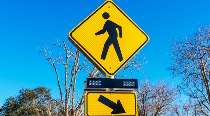
Pedestrian injuries and fatalities have significant personal, societal, and financial impacts, making it crucial to identify effective strategies to improve pedestrian safety. A research project by the UMN’s Human Factors Safety Laboratory (HFSL) evaluated the effectiveness of both temporary (i.e., quick-build) and permanent pedestrian-focused intersection features, such as curb extensions and pedestrian refuge islands. Researchers sought to understand how these features changed pedestrian and driver behavior — and how that affected safety.

Minnesota, in line with nationwide trends, saw an increase in pedestrian deaths between 2013 and 2022 (from 1.55 to 2.33 deaths per 100,000 nationwide). Similar high-income countries generally experienced a decrease in pedestrian deaths in the same period. “This remains a hot-button topic for research in the traffic safety space,” said HFSL research associate Curtis Craig, lead investigator on the project and CTS scholar, in a webinar discussing the research. The project was sponsored by the Minnesota Department of Transportation and the Minnesota Local Road Research Board.

Several unique factors make U.S. roadways especially challenging for pedestrians. “The high incidence of large trucks and SUVs makes it more difficult to see pedestrians, and any impact would be more severe because of the greater mass and geometry of the front grills on those vehicles,” Craig said. “There’s also simply a large preponderance of high-speed, multi-lane roads, which is a high-risk factor for pedestrians and drivers.”

Pedestrian-friendly infrastructure strategies aim to reduce those risks. With guidance from Minneapolis’s Vision Zero 2023–2024 pedestrian safety plan, researchers identified 12 intersections in Minneapolis and St. Paul to study before and after the installation of quick-build pedestrian infrastructure and concrete infrastructure. Quick-build infrastructure includes temporary or plastic features, such as bollards replicating bump-outs and sidewalk extensions. The goal of the study was to compare the safety influence on driver behavior of these quick-build features with those of permanent concrete infrastructure.

The study evaluated a mix of signalized and unsignalized intersections with temporary and permanent infrastructure features in a variety of income areas and with various levels of pedestrian and vehicle traffic. The team recorded driver behavior in pass-through and right-turn intersections. Data was collected in staged and natural pedestrian crossings using both in-person observations and video to record driver speeds, stops, and pedestrian behavior. The video footage was analyzed with the help of artificial intelligence algorithms.

The study found that whether permanent or temporary, the presence of the installations generally improved the rates of drivers stopping for pedestrians and led to a small but significant decline in traffic speeds at intersections. Temporary median refuges reduced the average speeds of drivers in free-flowing traffic at both signalized and unsignalized intersections. Since high driver speed is associated with a higher likelihood of pedestrian fatalities and higher injury severity, this is an especially meaningful benefit, Craig noted.

However, using flexible delineators as temporary curb extensions slightly reduced the likelihood of drivers stopping for pedestrians compared to permanent infrastructure, particularly at signalized intersections. The researchers noted a decline in stopping rates, for right-turning drivers at signalized intersections outfitted with temporary curb extensions, while the permanent, concrete curb extensions appeared to perform slightly better. The researchers speculated that the presence of bollards or other features surrounding the temporary infrastructure created a distraction, or “clutter,” that diverted drivers’ attention away from pedestrians as they navigated the intersection turn. “It’s a more visually complex environment, with more cars and more pedestrians to look out for,” Craig said.

The flexible delineators used cost between $30 and $100 each plus labor for installation, and most intersections require 12 delineators. Meanwhile, permanent concrete extensions cost about $18,000 each (or more if installation requires interaction with the sewage system) and median islands cost as much as $55,000. However, the study emphasizes that fatal pedestrian crashes have a tremendous cost. Beyond devastating personal and societal impacts, researchers point to a 2020 assessment by the U.S. Centers for Disease Control and Prevention that tallied more than $68 million in medical and work-loss costs related to pedestrian fatalities.

No two intersections in the study could be considered identical; the presence or lack of on-street parking, construction, and variations in pedestrian behaviors influenced each crossing. Craig said that future engineering projects considering the use of quick-build infrastructure need to weigh the many variables that define each intersection. Ultimately, when transportation infrastructure prioritizes pedestrians, public safety improves on Minnesota’s streets.

—Amy Goetzman, contributing writer

Related MnDOT research

Many MnDOT and LRRB projects have looked at pedestrian safety. Here is a sample of them.

Exploring the Factors Driving Vitality in Transportation Corridors: Lessons from Minnesota

Thursday, July 16, 2026, 10:00 am–2:00 pm

Bell Museum
The Nucleus Conference Room
2088 Larpenteur Avenue West
Saint Paul, MN 55113

About the Event

In a follow up to a March webinar, Economic Impacts of Freeway Corridors, this in-person event will share preliminary findings from an ongoing MnDOT research project studying the economic impacts of freeway corridors. There are many discussions about rethinking freeway corridor designs in Minnesota and nationally. Economic impacts should be considered when selecting a design alternative, but these are difficult to quantify. This research aims to provide a framework to better estimate the impacts of freeway corridor alternative projects by also considering mode, scale, land uses, community engagement practices, and environmental impacts.

Sponsored by the Institute for Urban and Regional Infrastructure Finance (IURIF) at the Humphrey School of Public Affairs, this event will focus on community engagement around infrastructure transformation. Presenters will discuss the intersection of 38th and Chicago in Minneapolis and share insights about how MnDOT approaches engagement for projects in Northeast Minnesota. In addition, IURIF researchers will lead an open discussion of each facet of the research around the economic impacts of freeway corridors, including community engagement, land use, environmental aspects, and socioeconomic impacts.

Speakers

Alexander Kado is a senior project manager with the City of Minneapolis Office of Public Service, where he oversees critical infrastructure investments shaped by community voice. He is currently directing two legacy projects of immense civic significance: the redevelopment of George Floyd Square and the creation of the Minneapolis Democracy Center — a transformation of the former Third Precinct building into a space for civic participation. Guided by a commitment to equitable urban outcomes, Alexander bridges technical precision with social advocacy. He holds a master’s degree in city and regional planning from the University of North Carolina – Chapel Hill and a BS in mechanical engineering from the University of Minnesota Twin Cities.

Duane Hill is a 1988 graduate of North Dakota State University with a BS in civil engineering. He has more than 38 years of engineering experience, mostly in the transportation field with the Minnesota Department of Transportation. Duane’s experience includes highway design, project management, environmental, construction engineering, bridge engineering and field operations management. Duane has been the district engineer in MnDOT District One since March 2012.

Registration

The event is free, but registration is required.

Rough roads? How everyday cars might help flag trouble spots

Reprinted from CTS News, May 11, 2026

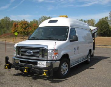
To assess pavement conditions throughout the state, the Minnesota Department of Transportation (MnDOT) uses a van specially equipped with advanced technology that measures roughness, cracking, and other signs of distress on a roadway’s surface. That system has its limitations, however. The vans cost about $800,000 each, and the data collection requires extensive coordination, trained personnel, and sensitive equipment that is limited to operating in warmer summer months. In addition, the data collection takes place once a year on MnDOT routes and every other year on County State Aid Highways.

van equipped with technology to measure pavement conditions
Mn/DOT’s Pathway Services, Inc. Digital Inspection Vehicle (DIV)

Could there be a more efficient and more timely way to assess the state’s road pavement conditions? To find out, researchers at the University of Minnesota (UMN) explored whether data already being generated by everyday vehicles could enhance MnDOT’s current method. 

To test this, UMN researchers equipped study vehicles with a simple plug-in scanner that captured onboard diagnostics data, explains CTS scholar Raphael Stern, the project’s co-investigator and UMN associate professor of civil, environmental, and geo- engineering. Modern vehicles already have sensors that collect this data, which can be used to monitor and optimize vehicle performance. That same data could provide clues to how a vehicle is responding to pavement beneath it, he says.

“If we could show that this can be done in Minnesota, MnDOT or local agencies can implement this technology,” says lead investigator and CTS scholar Mihai Marasteanu. “They could have a very good idea about the conditions of pavement every day—not just once a year.”

For this project, researchers adapted methodologies from Denmark’s Live Road Assessment (LiRA) project, considered to be the most comprehensive effort to use onboard vehicle sensors for continuous pavement monitoring. That initiative provided insights into both the technical feasibility and practical challenges of extracting meaningful pavement quality metrics from standard vehicle data.

Researchers tested a similar approach on three routes in Minnesota to capture a diverse range of pavement conditions under real-world driving scenarios. One route was a 15-mile loop in the northeast Twin Cities metropolitan area that covered urban and suburban road segments with consistent traffic flow. Another was a 96-mile loop between Minneapolis and Northfield, comprising a mix of urban, suburban, and rural roadways. The third was the 2.6-mile loop at MnROAD, MnDOT’s research facility near Albertville.

The plug-in scanner collected data on vehicle location, speed, and 3D acceleration; the last measures the intensity and complexity of vibrations transmitted from the road through the vehicle’s suspension system.

Across the three routes, researchers collected more than 9,000 data points. Machine learning models used 694 data values to predict pavement quality using the International Roughness Index (IRI) for a given pavement section.

Researchers compared and validated predictions against data from MnDOT and a commercial pavement‑monitoring system. Results demonstrated a correlation across diverse road conditions, although accuracy decreased in areas where pavement conditions changed quickly or road surfaces had defects. Predictions were also more accurate on highway segments than local roads because of variable urban driving environments.

Of the eight learning models evaluated, one achieved 94 percent accuracy on predicting pavement roughness. The performance of each model varied based on environmental factors, data collection conditions, and road types.

The research successfully demonstrated that vehicle sensor data can effectively support continuous infrastructure monitoring, Marasteanu says. “It could save money in the long run and give a much more accurate representation of pavement conditions over the entire year,” he notes.

The project, funded by MnDOT, included implementation guidelines for large-scale deployment, equipment standardization protocols, data-processing pipelines, and risk-mitigation strategies.

MnDOT is now exploring how to extend the research beyond the study vehicles, says Curt Turgeon, director of MnDOT’s Office of Materials and Road Research. One way will be to use commercial data sources that already collect similar information from everyday vehicles. For example, NIRA Dynamics, headquartered in Sweden, partners with automakers Volkswagen and Volvo to collect anonymized sensor data from consumer vehicles. These data streams are captured continuously throughout the year.

“MnDOT has a contract with NIRA to determine how this data might enhance our pavement management decisions as well as potentially document snow and ice response,” he says. “They also have a module that may flag potholes or other in-road hazards based upon vehicles swerving.”

—Peter Raeker, contributing writer

Related reading

Continue reading Rough roads? How everyday cars might help flag trouble spots

Addressing disparities through more equitable transportation planning

Reprinted from CTS Catalyst April 16, 2026

Transportation capital investment planning plays a vital role in shaping the future of infrastructure—but often leaves people with disabilities, youth, older adults, people of color, and disadvantaged communities underserved. A recent UMN research project aimed to gain a better understanding of how to include equity in planning and decision making.

To gain a better understanding of how to include equity in planning and decision making, a recent research project explored this complex topic through a literature review, statewide survey, and analysis of case studies. This research, sponsored by the Minnesota Department of Transportation (MnDOT) and the Minnesota Local Road Research Board, resulted in considerations and strategies, including a toolkit, to increase community engagement and guide future transportation development for Minnesota localities and Native nations.

Camila Fonseca-Sarmiento, director of fiscal research for the Institute for Urban & Regional Infrastructure Finance at the University of Minnesota’s Humphrey School of Public Affairs and a CTS scholar, led a team of researchers through a review of case studies for which equity was included in capital investment planning. As in other states and localities across the United States, the team found that the definition of equity and the goals of equity-related funding ranged widely across Minnesota’s counties, cities, and Native nations.

Incorporating equity factors in transportation investment planning in Minnesota has occurred through small, incremental changes. A few jurisdictions have already integrated equity into their planning efforts, while some others are in the process of doing so. Jurisdictions with a more comprehensive equity framework are those in which equity is part of a local initiative, compared to those who mentioned equity efforts as a response to federal funding requirements, such as Title VI of the Civil Rights Act of 1964 and the Americans with Disability Act.+6

Minnesota brings an additional set of equity considerations through the inclusion of the state’s 11 Native nations. These Ojibwe and Dakota communities and reservations share many of the same needs and challenges as other localities but also possess unique cultural considerations, including sovereignty, sacred sites, and environmental protection. For example, on a practical level equity for Native nations means fair employment—equitable job opportunities, wages, and hiring preferences for tribal members to ensure benefits stay within the tribal nations on or near reservations. On a cultural level it means dual language signage for English and Ojibwe or Dakota on roads and highways that traverse Native lands.

“Equity is not a one-size-fits-all approach,” Fonseca-Sarmiento says. Engaging community members early in the planning process helps planners understand transportation needs beyond roadway investments—such as a community’s historical experience, culturally specific needs, and current gaps. The research findings offer guidance on how to gather local input through surveys and in-person meetings guided by trained staff. 

The transportation capital investment planning and decision-making process consists of several phases where equity could be integrated: identifying projects, prioritizing capital investment projects through multi-step processes, and selecting projects for funding through community advisory committees.

A toolkit developed by the researchers could help improve communication and engagement with underserved communities. Its two key tenets are that agencies need to proactively reach out to the community, and trust-building is essential for effective relationships.

In addition, Dillon Dombrovski, deputy public works director/city engineer with the City of Rochester and the project’s technical liaison, says the community engagement toolkit “provides effective guidance to combine community input with supporting data to invest in more equitable transportation projects.”

Fonseca-Sarmiento says it’s also critical to listen and then include diverse perspectives in the final transportation plan. “Engaging local stakeholders in the planning process but then leaving them out of the finished project decreases trust and limits future engagement,” she says. “Overall, having regular community engagement for identifying transportation capital investment projects can also help prevent perpetuating past inequities.”

Amy Goetzman, contributing writer

Related reading

CTS Webinar: Infrastructure Materials and Performance

Tuesday, April 21, 2026
noon–1:30 p.m. CDT, Virtual

About the Event

Understanding how infrastructure materials perform over time is critical to making informed design, construction, and maintenance decisions. This webinar will feature two recent University of Minnesota research efforts that examined the real-world performance of commonly used transportation infrastructure materials.

Continue reading CTS Webinar: Infrastructure Materials and Performance

CTS Webinar: EV Infrastructure and Fuel Policy—Understanding the Transportation and Economic Impacts

Thursday, April 23, 2026, 2:00–3:30 pm, Virtual

About the Webinar

Transportation policy and energy markets are evolving rapidly as states explore strategies to reduce emissions and support new fuel technologies. This webinar will examine two current policy areas shaping transportation systems: electric vehicle infrastructure development and low-carbon fuel standards.

Beth Kallestad from MnDOT’s Office of Sustainability and Public Health will provide an overview of Minnesota’s Electric Vehicle Infrastructure Program. Her presentation will discuss how the Infrastructure Investment and Jobs Act and NEVI funding have shaped the development of EV infrastructure in Minnesota, the program’s current status, and what to expect in the next phase of implementation.

Monica Haynes and Neil Wilmot from the University of Minnesota Duluth will highlight a 2025 study that examined the relationship between low-carbon fuel standard (LCFS) programs and gasoline prices. They will explore how LCFS programs in other states have affected retail fuel costs and discuss the challenges of predicting the economic impacts of a potential LCFS program in Minnesota.

Through these presentations, webinar attendees will gain insights into how emerging transportation energy policies influence infrastructure planning and economic outcomes.

Speakers

Beth Kallestad is the sustainable transportation planning director with MnDOT’s Office of Sustainability and Public Health. She has a wide range of experience in the environmental field, including in the private, government, academic, and nonprofit sectors.  This experience has given her a strong background in the management and implementation of a variety of sustainability planning efforts, public and stakeholder engagement, effective communications, trust building, and collaboration. Beth joined MnDOT in June 2022 and has focused her work on the development and implementation of the EV infrastructure program with federal NEVI funding and supporting MnDOT’s internal fleet transition. 

Monica Haynes has served as the director of the Bureau of Business and Economic Research at the University of Minnesota Duluth since 2014, supervising a small team of student researchers and a writer/editor. During her time in this role, the department has completed more than 90 funded research projects on a wide range of topics related to current events, proposed development opportunities, and economic trends. She also serves as adjunct faculty in the Labovitz School of Business and Economics (LSBE), as chair of LSBE’s outreach committee, and on the Duluth Workforce Development Board. 

Neil A. Wilmot is an associate professor and head of the Department of Economics and Health Care Management, Labovitz School of Business and Economics, at the University of Minnesota Duluth. He is also an associate of the Institute on the Environment at the University of Minnesota. Wilmot’s research interests include energy economics and energy commodities, encompassing a wide range of topics including oil and gas markets, renewable energy integration, and energy pricing mechanisms. He has published numerous articles in leading energy economics journals, including Energy EconomicsResource and Energy Economics, and The Energy Journal.

Registration

This webinar is free, but registration is required. Once you have registered, you will receive an email confirmation with a Zoom link. The link should not be shared with others; it is unique to you.

Related Reading

Transitioning to EV Fleets: Best Practices and a Decision Tool | MnDOT Digital Library

CTS Webinar: Species from Feces—A New Tool to Identify Bats in Culverts and on Bridges

Wednesday, April 22, 2026, 12:00–1:30 pm, Virtual

About the Webinar

Bats frequently use bridges and culverts as roosting habitat, creating challenges for transportation agencies working to balance infrastructure needs with environmental compliance. Traditional visual surveys can be limited, especially when bats are hidden within structures or present only intermittently. 

This webinar will highlight ongoing research exploring the use of DNA analysis from bat feces (guano) as a noninvasive method to identify bat species occupying culverts and bridges. Speaker Ron Moen will discuss how this approach works, share early findings from field applications, and explore how the results could support more efficient environmental review, project planning, and species protection efforts for transportation agencies.

It is being held in conjunction with a CTS Environment and Energy in Transportation Council meeting.

Speaker

Ron Moen is an associate professor in the Department of Biology at the University of Minnesota Duluth and a senior research associate with the Natural Resources Research Institute’s Center for Water and the Environment. His research focuses on mammalian ecology, including habitat use, movement patterns, and predator–prey interactions, often using GPS radiotelemetry. His current work includes studies on moose, Canada lynx, American marten, wood turtles, bats, and other wildlife, as well as projects related to climate change impacts and carnivore monitoring in the Upper Midwest.

Registration

This webinar is free, but registration is required. Once you have registered, you will receive an email confirmation with a Zoom link. The link should not be shared with others; it is unique to you.

Follow the Research

Species From Feces: A New Tool to Identify Bats in Culverts and on Bridges

Call for Presentations: 2026 CTS Transportation Research Conference

The Center for Transportation Studies at the University of Minnesota has called for speakers. If you have recently completed or participated in an innovative transportation-related research, implementation, or engagement activity, consider sharing your work in a presentation at the 2026 CTS Transportation Research Conference!

Continue reading Call for Presentations: 2026 CTS Transportation Research Conference

CTS Webinar: Industry and International Perspectives on AI Integration

Wednesday, April 1, 2026, 9:00–10:30 am CST, Virtual

Artificial intelligence (AI) is increasingly influencing how transportation and infrastructure projects are planned, delivered, and communicated. This Education and Engagement Council webinar builds on CTS’s earlier AI discussion by highlighting how AI is being used in practice, both nationally and internationally.

Speakers from outside Minnesota will share real-world examples of AI integration in infrastructure and construction contexts. Nicole Moon, Strategic Communications Highways and Roads Market Sector Lead at HDR, will discuss how AI is supporting transportation agencies and project teams through applied industry use.


Mr. Tomi Kotala, Project Director, City of Helsinki Public Works Department, and Mr. Pieti Marjavaara, Chief Innovation Officer, Construction Management, AINS Group, will discuss the Infrastructure Programme Helsinki, Finland. This strategic urban development initiative focused on designing and constructing a sustainable future for the city, including a massive expansion of the Light Rail Transit (LRT) network. They will demonstrate how their approach to Integrated Project Delivery (IPD) and alliance models optimizes infrastructure lifecycles through fair partnership. Efficiency is driven by Knowledge Management and industrial construction via data-driven, repeatable processes. The Project-AI concept evolves situational awareness into active AI-driven support for all project members, ensuring smarter, more predictable, and value-driven outcomes.

This webinar is designed to foster shared learning and discussion around how AI is being adopted today, why organizations are investing in these tools, and what lessons transportation professionals can take from industry and international experience. It is intended for practitioners, researchers, students, and others interested in the evolving role of AI in transportation and infrastructure.

Continue reading CTS Webinar: Industry and International Perspectives on AI Integration

Household-based travel measures may help agencies cut emissions

Reprinted from Catalyst, December 15, 2025

Across the country, transportation agencies, including the Minnesota Department of Transportation (MnDOT), are working to meet ambitious targets for reducing vehicle miles traveled (VMT) and climate emissions. To succeed, they need to understand what actually encourages households to drive less. 

A recent University of Minnesota (UMN) research study aimed to answer this question. Led by Eric Lind, director of the UMN’s Accessibility Observatory, the study examined how accessibility—the opportunities reachable by different travel modes such as driving, public transit, or biking—influences a household’s VMT. 

“We wanted to go beyond the typical approach of using roadway volume counts and instead examine households, because that is where VMT comes from,” Lind says. “This helps us better understand the influence of transportation and land-use systems on the travel decisions people make in their daily lives.”

Lind and his research team used Twin Cities travel behavior survey records to match households with access to opportunities on three different levels: local access (biking to jobs within 20 minutes), transit access (walking or rolling to transit to reach jobs within 10 to 40 minutes), and regional access (driving to jobs within 20 to 60 minutes). The models also accounted for important demographic factors including household income, vehicle availability, and number of workers.

The findings point to a challenging road ahead for transportation agencies working to reduce VMT and greenhouse gas emissions. The good news is that higher local and transit access does lead to lower expected VMT. However, the impact is modest: doubling local or transit access to jobs results in a VMT decrease of about 3 percent. 

Conversely, higher regional auto access is the most influential factor and positively predicts higher VMT. According to the model, a modest 10 percent increase in regional auto access to jobs resulted in a VMT increase of roughly 4 percent.

“The challenge is that MnDOT is required to balance increasing roadway capacity with strategies that reduce VMT to the same extent,” Lind explains. “Increasing what is easily reachable by bike or transit does lead people to drive less, but these are nudges compared with the main effects of roadway expansions that have a much larger, counteracting effect on VMT.”

To meet VMT goals, the research team recommends a two-pronged approach. First, agencies must continue to invest in and increase local and transit and nonmotorized access. Second, they must critically assess any planning that increases regional auto access, as its VMT-boosting impact requires non-auto mitigation to balance it out. 

These findings will provide MnDOT and other transportation agencies with a clearer understanding of the levers available to them, offering the estimates needed to calculate the true VMT impact of future infrastructure changes.

This study was sponsored by the Applied Research in Transportation (ART) Program, which addresses time-sensitive research questions in a 6- to 12-month timeframe. CTS and MnDOT contributed initial funding to launch this pilot program in 2024, with the Metropolitan Council joining in 2025. To reinforce the applied nature of the program, ART projects must directly address a current process, document, or policy need with an initial focus on sustainability in transportation and climate change impacts.

Related topics

For an overview of travel behavior in the U.S. generally, see Ten years of measurement reveals evolution of destination access across America.

To see how the transportation system is performing in Minnesota, see MnDOT performance measures.