

Reprinted from CTS News, May 11, 2026
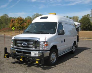
To assess pavement conditions throughout the state, the Minnesota Department of Transportation (MnDOT) uses a van specially equipped with advanced technology that measures roughness, cracking, and other signs of distress on a roadway’s surface. That system has its limitations, however. The vans cost about $800,000 each, and the data collection requires extensive coordination, trained personnel, and sensitive equipment that is limited to operating in warmer summer months. In addition, the data collection takes place once a year on MnDOT routes and every other year on County State Aid Highways.
Could there be a more efficient and more timely way to assess the state’s road pavement conditions? To find out, researchers at the University of Minnesota (UMN) explored whether data already being generated by everyday vehicles could enhance MnDOT’s current method.
To test this, UMN researchers equipped study vehicles with a simple plug-in scanner that captured onboard diagnostics data, explains CTS scholar Raphael Stern, the project’s co-investigator and UMN associate professor of civil, environmental, and geo- engineering. Modern vehicles already have sensors that collect this data, which can be used to monitor and optimize vehicle performance. That same data could provide clues to how a vehicle is responding to pavement beneath it, he says.
“If we could show that this can be done in Minnesota, MnDOT or local agencies can implement this technology,” says lead investigator and CTS scholar Mihai Marasteanu. “They could have a very good idea about the conditions of pavement every day—not just once a year.”
For this project, researchers adapted methodologies from Denmark’s Live Road Assessment (LiRA) project, considered to be the most comprehensive effort to use onboard vehicle sensors for continuous pavement monitoring. That initiative provided insights into both the technical feasibility and practical challenges of extracting meaningful pavement quality metrics from standard vehicle data.
Researchers tested a similar approach on three routes in Minnesota to capture a diverse range of pavement conditions under real-world driving scenarios. One route was a 15-mile loop in the northeast Twin Cities metropolitan area that covered urban and suburban road segments with consistent traffic flow. Another was a 96-mile loop between Minneapolis and Northfield, comprising a mix of urban, suburban, and rural roadways. The third was the 2.6-mile loop at MnROAD, MnDOT’s research facility near Albertville.
The plug-in scanner collected data on vehicle location, speed, and 3D acceleration; the last measures the intensity and complexity of vibrations transmitted from the road through the vehicle’s suspension system.
Across the three routes, researchers collected more than 9,000 data points. Machine learning models used 694 data values to predict pavement quality using the International Roughness Index (IRI) for a given pavement section.
Researchers compared and validated predictions against data from MnDOT and a commercial pavement‑monitoring system. Results demonstrated a correlation across diverse road conditions, although accuracy decreased in areas where pavement conditions changed quickly or road surfaces had defects. Predictions were also more accurate on highway segments than local roads because of variable urban driving environments.
Of the eight learning models evaluated, one achieved 94 percent accuracy on predicting pavement roughness. The performance of each model varied based on environmental factors, data collection conditions, and road types.
The research successfully demonstrated that vehicle sensor data can effectively support continuous infrastructure monitoring, Marasteanu says. “It could save money in the long run and give a much more accurate representation of pavement conditions over the entire year,” he notes.
The project, funded by MnDOT, included implementation guidelines for large-scale deployment, equipment standardization protocols, data-processing pipelines, and risk-mitigation strategies.
MnDOT is now exploring how to extend the research beyond the study vehicles, says Curt Turgeon, director of MnDOT’s Office of Materials and Road Research. One way will be to use commercial data sources that already collect similar information from everyday vehicles. For example, NIRA Dynamics, headquartered in Sweden, partners with automakers Volkswagen and Volvo to collect anonymized sensor data from consumer vehicles. These data streams are captured continuously throughout the year.
“MnDOT has a contract with NIRA to determine how this data might enhance our pavement management decisions as well as potentially document snow and ice response,” he says. “They also have a module that may flag potholes or other in-road hazards based upon vehicles swerving.”
—Peter Raeker, contributing writer
Related reading
- Using Electric Vehicle Onboard Data for Pavement Quality Assessment and Management (PDF)
- Using Onboard Vehicle Data to Assess Pavement Quality (PDF)
- Using Onboard Vehicle Data to Assess Pavement Quality (Blog Post)
- The Danish Road Directorate (web site)
- An Overview of Mn/DOT’s Pavement Condition Rating Procedures and Indices (PDF)
