Tag Archives: safety

Research finds pedestrian-focused infrastructure can boost safety

Article reprinted from CTS News, August 12, 2026.

Published MnDOT Report: Behavioral Investigation of Temporary and Permanent Pedestrian Infrastructure

Pedestrian injuries and fatalities have significant personal, societal, and financial impacts, making it crucial to identify effective strategies to improve pedestrian safety. A research project by the UMN’s Human Factors Safety Laboratory (HFSL) evaluated the effectiveness of both temporary (i.e., quick-build) and permanent pedestrian-focused intersection features, such as curb extensions and pedestrian refuge islands. Researchers sought to understand how these features changed pedestrian and driver behavior — and how that affected safety.

Minnesota, in line with nationwide trends, saw an increase in pedestrian deaths between 2013 and 2022 (from 1.55 to 2.33 deaths per 100,000 nationwide). Similar high-income countries generally experienced a decrease in pedestrian deaths in the same period. “This remains a hot-button topic for research in the traffic safety space,” said HFSL research associate Curtis Craig, lead investigator on the project and CTS scholar, in a webinar discussing the research. The project was sponsored by the Minnesota Department of Transportation and the Minnesota Local Road Research Board.

Several unique factors make U.S. roadways especially challenging for pedestrians. “The high incidence of large trucks and SUVs makes it more difficult to see pedestrians, and any impact would be more severe because of the greater mass and geometry of the front grills on those vehicles,” Craig said. “There’s also simply a large preponderance of high-speed, multi-lane roads, which is a high-risk factor for pedestrians and drivers.”

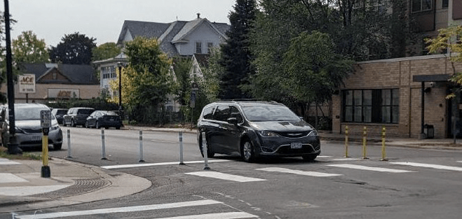
Pedestrian-friendly infrastructure strategies aim to reduce those risks. With guidance from Minneapolis’s Vision Zero 2023–2024 pedestrian safety plan, researchers identified 12 intersections in Minneapolis and St. Paul to study before and after the installation of quick-build pedestrian infrastructure and concrete infrastructure. Quick-build infrastructure includes temporary or plastic features, such as bollards replicating bump-outs and sidewalk extensions. The goal of the study was to compare the safety influence on driver behavior of these quick-build features with those of permanent concrete infrastructure.

The study evaluated a mix of signalized and unsignalized intersections with temporary and permanent infrastructure features in a variety of income areas and with various levels of pedestrian and vehicle traffic. The team recorded driver behavior in pass-through and right-turn intersections. Data was collected in staged and natural pedestrian crossings using both in-person observations and video to record driver speeds, stops, and pedestrian behavior. The video footage was analyzed with the help of artificial intelligence algorithms.

The study found that whether permanent or temporary, the presence of the installations generally improved the rates of drivers stopping for pedestrians and led to a small but significant decline in traffic speeds at intersections. Temporary median refuges reduced the average speeds of drivers in free-flowing traffic at both signalized and unsignalized intersections. Since high driver speed is associated with a higher likelihood of pedestrian fatalities and higher injury severity, this is an especially meaningful benefit, Craig noted.

However, using flexible delineators as temporary curb extensions slightly reduced the likelihood of drivers stopping for pedestrians compared to permanent infrastructure, particularly at signalized intersections. The researchers noted a decline in stopping rates, for right-turning drivers at signalized intersections outfitted with temporary curb extensions, while the permanent, concrete curb extensions appeared to perform slightly better. The researchers speculated that the presence of bollards or other features surrounding the temporary infrastructure created a distraction, or “clutter,” that diverted drivers’ attention away from pedestrians as they navigated the intersection turn. “It’s a more visually complex environment, with more cars and more pedestrians to look out for,” Craig said.

The flexible delineators used cost between $30 and $100 each plus labor for installation, and most intersections require 12 delineators. Meanwhile, permanent concrete extensions cost about $18,000 each (or more if installation requires interaction with the sewage system) and median islands cost as much as $55,000. However, the study emphasizes that fatal pedestrian crashes have a tremendous cost. Beyond devastating personal and societal impacts, researchers point to a 2020 assessment by the U.S. Centers for Disease Control and Prevention that tallied more than $68 million in medical and work-loss costs related to pedestrian fatalities.

No two intersections in the study could be considered identical; the presence or lack of on-street parking, construction, and variations in pedestrian behaviors influenced each crossing. Craig said that future engineering projects considering the use of quick-build infrastructure need to weigh the many variables that define each intersection. Ultimately, when transportation infrastructure prioritizes pedestrians, public safety improves on Minnesota’s streets.

—Amy Goetzman, contributing writer

Related MnDOT research

Many MnDOT and LRRB projects have looked at pedestrian safety. Here is a sample of them.

New Project: Does lowering speed limits reduce driver speeds on urban streets?

In 2019, the Minnesota Legislature passed a law reducing barriers for cities to systematically lower speed limits. The City of St. Louis Park followed this guidance by reducing speed limits in 2021, but initial speed data collected before and 6–8 months after the changes showed little to no short‑term impact. Because driver behavior is habitual and may change slowly, advocates suggest that greater reductions in operating speeds may emerge over time, highlighting the need for repeat monitoring between 2025 and 2027.

This study aims to evaluate whether longer‑term changes have occurred 2–4 years after the initial reductions, while also examining other Minnesota agencies that have implemented or are considering reduced speed limits. The research will gather both measured and anecdotal data, assess “after” speed conditions where needed, and analyze how effectiveness varies based on roadway characteristics and any accompanying speed reduction countermeasures. These efforts address lingering questions about how speed limit changes influence driver behavior and roadway safety over time.

Understanding speed is critical because it directly affects the safety of all road users. According to Minnesota Motor Vehicle Crash Facts 2022, speeding was the leading cause of traffic fatalities, contributing to 130 of the state’s 444 deaths. By identifying agencies that have reduced speed limits, evaluating short‑ and long‑term impacts, and analyzing site‑specific factors, this research will produce guidance to help Minnesota road agencies assess and implement effective speed limit reductions.

“There is renewed interest in lower speed limits on municipal-type streets,” said Victor Lund, traffic engineer with St. Louis County’s Public Works Department. “The objective of this research is to better understand the intersection of speed limit policy, driver behavior and safety, which will result in guidance to better inform policies, practices and speed limits that support safer streets.”

The Objectives:

  1. Identify local agencies in Minnesota that have implemented reduced speed limits or may consider implementation along with any speed reduction countermeasures that have been implemented with the reduced speed limits.
  2. Evaluate the short-term and long-term effects of speed limit reductions implemented in Minnesota through the collection and analysis of speed data.
  3. Assess how these effects vary based on site characteristics or speed reduction countermeasures that were implemented in coordination with the reduced speed limit.
  4. Based on the findings, develop a summary document to aid Minnesota road agencies in assessing potential speed limit reductions.

Project Details:

  • Estimated Start Date: 06/25/2025
  • Estimated Completion Date: 06/30/2027
  • Funding: MnDOT and Local Road Research Board
  • Principal Investigator: Peter Savolainen
  • Co-Principal Investigators: Tim Gates
  • Technical Liaison: Victor Lund

Details of the research study work plan and timeline are subject to change.

To receive email updates about this project, visit MnDOT’s Office of Research & Innovation to subscribe.
CTS Webinar: How Infrastructure Shapes Driver Behavior and Pedestrian Safety

About the Event 

Improving pedestrian safety requires a deeper understanding of how people interact with roadway design and infrastructure. This webinar will highlight two recent research efforts examining how transportation infrastructure influences driver behavior and pedestrian safety outcomes.

Curtis Craig, a research associate in the Human Factors Safety Laboratory, will present findings from two complementary studies examining infrastructure at intersections. The first study explored how right turn lane configurations affect pedestrian safety using a combination of behavioral analysis and multiple research methods. The second project examined how drivers and pedestrians respond to different infrastructure treatments and how those designs influence behavior in real-world environments.

These study findings offer transportation agencies, planners, and engineers practical considerations as they work to create safer and more accessible pedestrian environments.

Registration and More

This webinar is free, but registration is required. Visit the event web page to register and for more information. 

Related Reading

Active Research by Curtis Craig

Analysis and Risk Management of Motorcycle, Bicycle, and Pedestrian Crashes in Minnesota

Administrative Rules and Structures of Speed Safety Camera Systems

Speed Safety Cameras (SSCs) detect the speed of vehicles through the use of radar technology or detectors that are embedded in the surface of the roadway, and associate those readings with a photograph or video of the vehicle. They can be deployed as fixed units (a stationary camera targeting a specific location), point-to-point units (multiple cameras that capture average speed over a set distance) or mobile (a portable camera positioned in a trailer or vehicle). The results are then “read” by trained analysts in a data center, who may or may not be members of law enforcement. Speeding tickets are then issued on the basis of this technology. The question facing the Minnesota Legislature in 2024 was, is this needed? And what are the best practices for implementing it?

Continue reading Administrative Rules and Structures of Speed Safety Camera Systems

Improving Traffic Signal Visibility

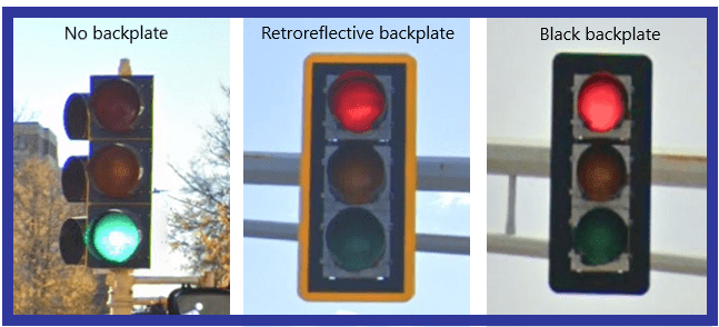
Inconspicuous traffic signals are often cited as contributing to collisions at intersections. If that is true, making traffic signals more conspicuous should lead to fewer crashes.  A study published at the TRB conference in 2005 suggested that yellow retroreflective backplates were most effective, reducing accidents by 15% at intersections, and the FHWA later adopted this as a Proven Safety Countermeasure.

Continue reading Improving Traffic Signal Visibility

New Project: Roadside Feature Placement and Pedestrian Safety on Low and Intermediate Speed Roads

Guidelines for designing and placing roadside features have traditionally focused on automobile safety on higher-speed roads. Research has also shown feature placement can have safety benefits for pedestrians and bicyclists on lower-speed roads.

Continue reading New Project: Roadside Feature Placement and Pedestrian Safety on Low and Intermediate Speed Roads

NCITE Webinar: LRRB Mini-Roundabout Guidance

Tuesday, August 6, 10-11 a.m., free to attend

Increasingly, local agencies are opting for mini-roundabouts for some locations instead of traditional roundabouts, which typically require a larger footprint than a standard four-way intersection. Mini-roundabouts are characterized by a small diameter and fully traversable islands (central island and splitter islands).

Join the Apex Engineering Group for a presentation on the Local Road Research Board project, Mini-Roundabout FAQs. Project team members Michael Marti and Zach Heimer with SRF Consulting Group and Jon Pratt with the City of Detroit Lakes will discuss this new guidance.

The guidebook defines mini and compact roundabouts and provides selection criteria on when to use them as well as details regarding the center treatment. The FAQ format provides easy navigation to technical information.

If you have difficulty accessing the meeting, use the meeting ID and passcode:

  • Meeting ID: 251 050 866 163
  • Passcode: tGP6ix

TZD Traffic Safety Hotdish: A Roadmap for Traffic Safety Culture Research and the Road Ahead

Wednesday, July 17, 2024  
10:00 – 11:15 a.m. CDT

As states and localities adopt a vision of zero traffic fatalities, greater attention must be given to communication, collaboration, leveraging resources, and applying a systemic approach to traffic safety which requires a change in culture among road users and traffic safety agencies. This change in culture is tied to education, engineering, enforcement, and emergency services.

This free virtual event will highlight the Traffic Safety Culture Research Roadmap, recently released by the National Academies of Sciences, Engineering, and Medicine. The roadmap (Research Report 1091) presents a path forward to promote traffic safety culture among state departments of transportation and other transportation safety agencies.

Dr. Wes Kumfer, who led the creation of the roadmap, will review its development and contents. Jay Otto will share example projects and show how they fit into research on traffic safety culture. Join us to learn how you can identify traffic safety culture research needs and get insights to take back to your own organizational cultures!

The webinar is free to attend, but registration is required. Once you have registered, you will receive an email confirmation with a Zoom link. The link should not be shared with others; it is unique to you.

New Project: Development of a System to Report School Bus Stop Arm Violations

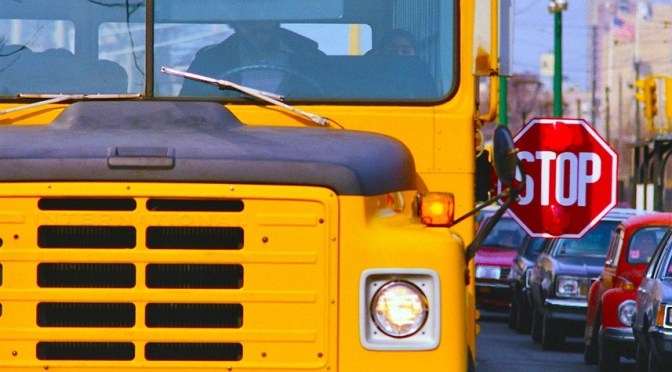
When a motorist ignores an extended school bus stop arm, it creates a direct and serious risk to children boarding and exiting a school bus. Capturing information about such incidents is a critical step in better understanding why they occur and how they can be prevented.

Continue reading New Project: Development of a System to Report School Bus Stop Arm Violations

New Project: Evaluation of Static and Dynamic No Right Turn on Red Signs at Traffic Signals

Making signalized intersections safer for pedestrians can be achieved by reducing points of conflict between pedestrians and vehicles. One source of conflict occurs when a vehicle makes a right turn on red (RTOR) onto a street in which pedestrians are crossing. During this turn, the driver must cross the path of pedestrians while at the same time searching for gaps in conflicting vehicle flow.

Continue reading New Project: Evaluation of Static and Dynamic No Right Turn on Red Signs at Traffic Signals