Tag Archives: Planning

Integrating travel demand management into transportation planning

Reprinted from Catalyst, June 22, 2026

Minnesota’s transportation landscape is rich with options designed to get travelers to their destinations safely and quickly. These modes, ranging from commuter bike trails and public transit to rideshares, buses, rail, roads, streets, and highways, are strategically interlinked; improvements or disruptions in one place reverberate across the greater transportation network.

Travel demand management (TDM) is an approach to transportation planning that encourages more efficient travel through a combination of mode choice and infrastructure design. This “big picture” approach centers the specific needs of local communities to create viable options for people to shift away from single-occupancy vehicles for at least some trips. Among the benefits of more efficient road use are improved congestion and air quality and reduced costs for road maintenance and construction.

A UMN research study led by Kaitlyn Denten, infrastructure policy researcher at the Institute for Urban and Regional Infrastructure Finance within the Humphrey School of Public Affairs and a CTS scholar, aimed to investigate how TDM strategies can best be integrated into highway construction projects.

In Minnesota, two factors are bringing the TDM approach to the forefront. The Transportation Greenhouse Gas Emissions Impact Assessment (Minn. Stat. §161.178 [2025]) is now part of highway construction and reconstruction projects. This statute requires projects to meet state greenhouse gas (GHG) and vehicle miles traveled (VMT) goals by either modifying the project, halting the project, or offsetting the GHG and VMT created by the project. 

Additionally, the Metropolitan Council, through its 2023 Regional Travel Demand Management Study Action Plan, recommended that a study be conducted to identify how TDM strategies could be incorporated into all phases of highway construction. The Met Council’s goal is to improve commuting, meet climate objectives, and reduce or delay the need for costly highway expansion projects.

In response to the Met Council’s recommendation, the UMN research team first conducted a nationwide scan to identify best practices for integrating TDM into highway projects. Examples in Colorado, California, New Jersey, Delaware, and Washington show how local, state, and federal transportation agencies and other entities coordinated to better understand local travel patterns and solve complex challenges. The scan revealed how TDM has been used to inform planning and policy, improve design and construction, encourage mode choice, and manage demand or emergency situations.

The researchers also studied Minnesota examples. The 2007 collapse of the I-35W Bridge in Minneapolis diverted 140,000 daily commuter trips. MnDOT, the Met Council, and regional stakeholders created travel alternatives from the time just after the collapse through the bridge’s reconstruction, which was completed in September 2008. TDM strategies included new transit services, fare subsidization, teleworking programs, and expanded park-and ride facilities.

In Duluth, a more northern expanse of Interstate 35W became a “mega project” between 2010 and 2012. During this time, 3 bridges and 12 miles of roadway pavement were replaced, shoulders and safety features were added, and intelligent transportation systems components were installed for emergency communications. TDM strategies helped facilitate communications between local and state entities, transit services, and the MnDOT construction teams to improve travel alternatives and ease the flow of traffic during this prolonged disruption.

TDM is becoming a more defined and important part of future transportation planning. “Ultimately, integrating TDM into highway projects enhances travel options and creates modal choices for travelers,” Denten says. “This reduces delay during peak times and improves safety and efficiency for construction crews. It can also remove the need for travel and push travel to non-peak times. Further, holistic TDM approaches for highway construction projects could lead to more efficient transportation systems and perhaps delay or remove the need for a highway project in the first place.”

The study offers best practices to help policymakers, planners, engineers, and local officials within the Metropolitan Council and beyond incorporate TDM into their projects. These strategies provide opportunities to shape policies and projects that respond to unexpected and intermittent challenges while supporting Minnesota’s long-term goals of reducing highway construction costs, climate impacts, and travel disruptions.

This research project was sponsored by the Applied Research in Transportation (ART) Program, which addresses time-sensitive research questions in a 6- to 12-month timeframe. CTS and the Minnesota Department of Transportation contributed initial funding to launch this pilot program in 2024, with the Metropolitan Council joining in 2025. To reinforce the applied nature of the program, ART projects must directly address a current process, document, or policy need with an initial focus on sustainability in transportation and climate change impacts. 

—Amy Goetzman, contributing writer

Low-Cost Pavement Condition Forecasting Software Eases Local Road Planning

The Minnesota Local Road Research Board (LRRB) has added pavement condition forecasting technology to an existing, web-based roadway inventory tool that will enable counties to generate low-cost maps and reports that help them prioritize their work by showing how roadway conditions will look under different construction scenarios for decades to come.

Continue reading Low-Cost Pavement Condition Forecasting Software Eases Local Road Planning

Resources Help Local Agencies Plan for CAV Roadway Needs

In a recently completed project, funded by the Local Road Research Board, researchers developed a reference tool and compiled a literature review that local agencies could use to anticipate the infrastructure needs of connected and automated vehicles. Agencies can use these resources to plan for infrastructure upgrades and maintenance activities.

Continue reading Resources Help Local Agencies Plan for CAV Roadway Needs

New manual helps agencies count bike, pedestrian traffic

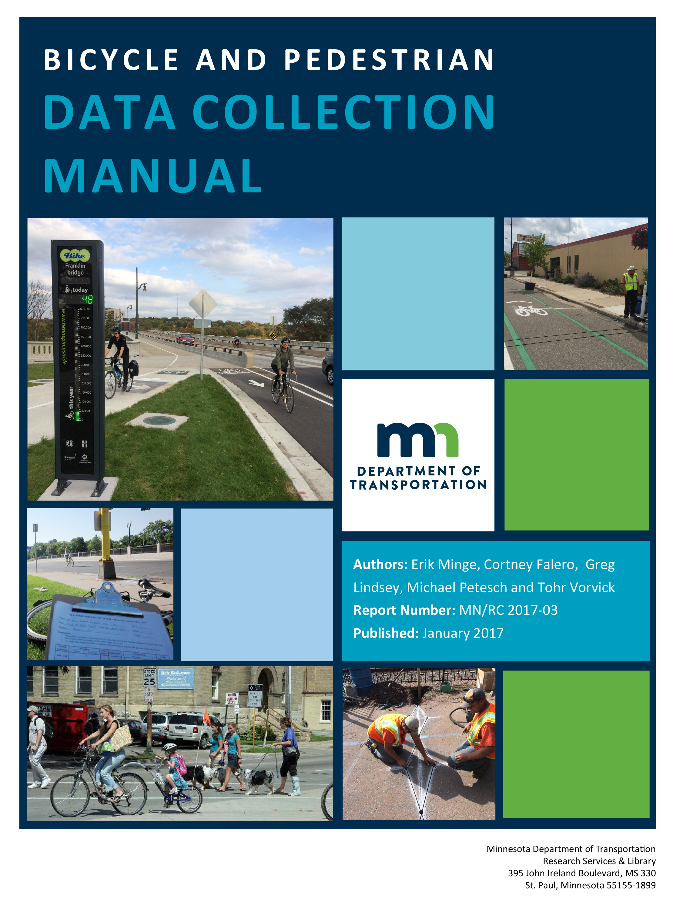
As part of an ongoing effort to institutionalize bicycle and pedestrian counting in Minnesota, MnDOT has published a new manual designed to help city, county, state, and other transportation practitioners in their counting efforts.

The Bicycle and Pedestrian Data Collection Manual, developed by University of Minnesota researchers and SRF Consulting Group, provides guidance and methods for collecting bicycle and pedestrian traffic data in Minnesota. The manual is an introductory guide to nonmotorized traffic monitoring designed to help local jurisdictions, nonprofit organizations, and consultants design their own programs.Bicycle and Pedestrian Data Collection Manual

Topics covered in the manual include general traffic-monitoring principles, bicycle and pedestrian data collection sensors, how to perform counts using several types of technologies, data management and analysis, and next steps for nonmotorized traffic monitoring in Minnesota. Several case studies illustrate how bicycle and pedestrian traffic data can be used to support transportation planning and engineering.

The manual was completed as part of the third in a series of MnDOT-funded projects related to the Minnesota Bicycle and Pedestrian Counting Initiative, a collaborative effort launched by MnDOT in 2011 to encourage nonmotorized traffic monitoring across the state. U of M researchers, led by professor Greg Lindsey at the Humphrey School of Public Affairs, have been key partners in the initiative since its inception.

In addition to the manual, U of M researchers have published a final report outlining their work with MnDOT on this project. Key accomplishments include:

  • A new statewide bicycle and pedestrian traffic-monitoring network with 25 permanent monitoring locations
  • A district-based portable counting equipment loan program to support MnDOT districts and local jurisdictions interested in nonmotorized traffic monitoring
  • Minnesota’s first Bicycle and Pedestrian Annual Traffic Monitoring Report
  • A MnDOT website for reporting annual and short-duration counts that allows local planners and engineers to download data for analysis
  • Provisions added to MnDOT equipment vendor agreements that enable local governments to purchase bicycle and monitoring equipment
  • Annual training programs for bicycle and pedestrian monitoring
  • Provisions in the Statewide Bicycle System Plan and Minnesota Walks that call for bicycle and pedestrian traffic monitoring and creation of performance measures based on counts

“This is an excellent resource that steps through all aspects of managing a count program, and I think it will be very helpful to other states and organizations that want to implement their own programs,” says Lisa Austin, MnDOT bicycle and pedestrian planning coordinator. “Since Minnesota is a leader in counting bicycle and pedestrian traffic, it also fulfills what I think is an obligation to share our story with others.”

Bicycle commuting improves public health, reduces medical costs

According to the results of a new study, bicycle commuting in the Twin Cities metropolitan area reduces chronic illness and preventable deaths, saving millions of dollars annually in medical costs.

The findings are one component of a multifaceted project funded by MnDOT. In the final report, researchers in several U of M departments provide a comprehensive understanding of the economic impact and health effects of bicycling in Minnesota.

“MnDOT has long identified bicycling as an important part of the state’s multimodal transportation system,” says Tim Henkel, modal planning and program management assistant commissioner. “This first-ever study generated new information that will inform policy and program strategies on bicycling as we determine levels of future investment.”

Xinyi Qian, an Assistant Extension Professor in the U’s Tourism Center, was the project’s principal investigator. Dr. Mark Pereira of the School of Public Health, one of the co-investigators, led the health component of the project.

Pereira’s team began by measuring the amount of bicycle commuting among Twin Cities adults using data from the 2014 Minnesota State Survey. (The counties included were Anoka, Carver, Dakota, Hennepin, Ramsey, Scott, and Washington.) The team found that 13.4 percent of working-age metro-area residents (244,000 adults) bicycle to work at least occasionally, and the average bicycle commuter rides 366 miles per year.

The researchers next estimated the number of deaths prevented from that amount of bicycling using the Health Economic Assessment Tool developed by the World Health Organization (WHO). Their analysis found that bicycle commuting in the metro area prevents 12 to 61 deaths per year, saving $100 million to $500 million annually. “At current levels, roughly 1 death per year is prevented for every 10,000 cyclists,” he says.

The WHO tool estimates savings from prevented deaths but not from prevented disease. To estimate the effect of bicycling commuting on illness, researchers conducted an online survey of Twin Cities cyclists; participants also included three commuter groups and a bicycle parts manufacturer.

“We learned that bicycling is linked to lower risk of metabolic syndrome, obesity, and hypertension,” Pereira says. “For example, taking three additional bicycle trips per week is associated with 46 percent lower odds of metabolic syndrome, 32 percent lower odds of obesity, and 28 percent lower odds of hypertension.”

The illness assessment provides relative risk estimates that planners can use in cost-benefit analyses. “Current methods only consider risk reductions related to death rates, so the benefit of infrastructure projects is underestimated,” Pereira says. “By providing an estimate of the risk reductions for diabetes and heart disease related to cycling, we provide an input that will help project planners more accurately represent the benefits of these projects.”

While the research was conducted in the Twin Cities, the methods can be used in other locations and to compare changes over time. “The findings also provide a foundation for transportation and health care officials to take action,” Pereira says, citing several options:

  • Promote active transportation through policies and intervention programs, e.g., employer incentives.
  • Develop consistent safety education and encouragement messages statewide to increase bicycle commuting.
  • Continue to encourage and implement safe bicycling to school and access to bicycles for youth across the state.

Roadway deaths and what Minnesota is doing about it

Joint article produced with MnDOT Research Services

Minnesota developed the Strategic Highway Safety Plan a decade ago, as the nation set a goal of reducing roadway deaths to less than one person per 100 million vehicle miles traveled. Last year, the nation still hadn’t reached this milestone (1.1 deaths occurred per 100 million miles), but Minnesota had lowered its fatality rate to 0.63 deaths (down from 1.48 deaths from 20 years ago).

“When I look at what Minnesota has done over the last 15 years compared to other states, we’re one of the few states that has a pretty consistent downward trend [in fatal crashes],” said Brad Estochen, MnDOT state traffic engineer, who gave an update on the highway safety plan during a recent presentation at the Roadway Safety Institute. “I think we’re doing some unique things here that have given us these results.”

These steps, Estochen says, have included passing a primary offense seatbelt law (seatbelt usage is now above 90 percent), investing in strategic safety infrastructure like high-tension cable median barriers and focused enforcement of DWI, speed and seatbelt laws.

Developing a plan

To best understand the risk factors for fatal and serious injury crashes, the state combined real-life crash data with input from professionals in engineering, law enforcement, emergency medical services, as well as everyday road users. The results showed that most crashes in the state involve multiple factors—such as road conditions, driver impairment and driver age.

Estochen said this approach of analyzing data and gaining stakeholder perspectives provided new insights into the dynamic causes of fatal and serious injury crashes.

In conjunction with the Departments of Health and Public Safety, MnDOT created a highway safety plan aimed at both professional stakeholders and the community that identified critical strategies for reducing serious traffic incidents. It has been updated in 2007 and 2014, most recently.

MnDOT also created a complimentary document for every county and MnDOT district (respectively called the county safety plan and district safety plan) to help local agencies identify locations and potential projects for reducing fatalities.

“We were the first state to take the SHSP concept to the local level. It was identified as a noteworthy practice by FHWA and other states are now starting to engage locals in developing specific plans for their use and implementation,” Estochen said.

The highway safety plan is an integral part of Toward Zero Deaths, the state’s cornerstone traffic safety program that has a goal of reducing fatalities to less than 300 per year by 2020.

Overall, Estochen said one of the best ways to reduce crashes in the state is to promote a culture of traffic safety — something he hopes the highway safety plan contributes to.

“Creating a traffic safety culture has nothing to do with building bigger and better roads,” he said. “It really has to do with making us as a state, as a community and as individuals responsible for our actions.”

Changing demographics and travel choices may shape a very different future

Though no one can predict the future, thinking about how today’s changes may shape the future of transportation in our country is more important now than ever before.

“It’s critical that we understand the significance of things that are taking place and prepare for what may come,” said former Utah Department of Transportation CEO John Njord in the opening session of the 25th Annual CTS Transportation Research Conference. “For us to be relevant in the transportation business, at a minimum we have to be adaptable to change, and ideally we want to be leading change in the transportation industry.”

In his current position at Tom Warne and Associates, Njord has gained an in-depth understanding of the trends affecting the future of transportation in the United States while spearheading the Transportation Research Board’s “Foresight” project—part of the organization’s forward-looking NCHRP Report 750 Series. The project addresses a wide range of topics, including: What if the oil-fueled auto era ends and revenue from gas taxes dries up? What if engineering practices must be upgraded to ensure resiliency to natural disasters as global warming continues? What if technology such as self-driving cars eliminates or reduces the need for human drivers? What if tomorrow’s economy requires radically different freight patterns?

Perhaps most significantly, the project explores the possibility that Americans are losing their appetite for driving. Vehicle-miles traveled (VMT) per capita been dropping since 2004, without any signs of recovery. “It’s impossible to know whether that number will start growing again, stay flat, or continue to drop,” Njord said.

Other trends make the future outlook equally complex. In 50 years the United States will likely be home to 100 million more people, so even if VMT per person stays flat or declines, it’s likely total VMT will be larger than it is today. The population is also aging: by 2030, 20 percent of the population will be over 65 and will likely drive less. In addition, Millenials are staying home longer and waiting until later in life to get married and have children—all of which affects their travel behavior.

To help transportation planners consider all possible futures, the Foresight project encourages the use of multiple-scenario planning. “We need to begin considering all the possible scenarios and generating plans that are independent and distinct from one another,” Njord advised. “The act of thinking about these things is fundamentally important, because the shift that is now taking place means we’re going to have to do things much differently in the next 50 years than what we’ve done in the past 50 years.”

Following Njord’s presentation, a panel of experts discussed how the the Foresight project could relate to what’s happening in the Twin Cities region. An article summarizing their comments is available in the July issue of Catalyst.