

The Minnesota Local Road Research Board (LRRB) has added pavement condition forecasting technology to an existing, web-based roadway inventory tool that will enable counties to generate low-cost maps and reports that help them prioritize their work by showing how roadway conditions will look under different construction scenarios for decades to come.
What Was the Need?
Many county road agencies present updated 5-year or 10-year plans to their county boards annually. In these plans, road system managers describe current roadway condition, traffic volumes and user needs, and illustrate the projects that could be completed with the current and projected funding options.
These five-year plans and budgetary assessments require up-to-date pavement inventory and condition information along with a method to project future roadway performance. Pavement management software can help with inventory data, but many of these programs are expensive, require staff expertise in geographic information systems (GIS) or information technology (IT), and demand attention that can be difficult for budget-conscious road agencies to prioritize. Without the aid of such software, the process of inventorying roads, predicting future pavement conditions and maintenance updates, and analyzing countywide needs and priorities is cumbersome and challenging.
“Agencies didn’t have a tool to predict future pavement conditions based on current conditions and maintenance plans. The new module provides these functions and is easy to use,” said Bradley Wentz, program director, Department of Transportation Support Center, Upper Great Plains Transportation Institute, North Dakota State University.
Simple roadway inventory management software would be invaluable to local road agencies, allowing agency staff to predict future pavement conditions based on current conditions and on maintenance and construction plans, and to generate visualizations and reports.
What Was Our Goal?
The LRRB sought to develop a pavement condition forecasting tool that would allow county agencies to predict future conditions on their roadway networks. LRRB proposed augmenting an inexpensive and user-friendly web-based roadway inventory management tool known as GRIT—Geographic Roadway Inventory Tool—to allow users to update inventory data and automatically combine it with updated pavement condition, traffic information, and maintenance and construction plans. The improved tool would also produce maps, graphs and reports on potential future pavement conditions.
What Did We Implement?
Investigators from the Upper Great Plains Transportation Institute (UGPTI) at North Dakota State University, which developed and manage GRIT, augmented the software with the pavement condition forecasting model.
Available to counties in North Dakota, South Dakota and Minnesota, GRIT allows local road agencies to enter data on roads for storage and review, focusing on construction history, culverts and small bridges, load restrictions and construction planning. The new module automatically updates the Minnesota GRIT database of construction and maintenance history with pavement condition and traffic data collected by MnDOT, requiring no additional effort by GRIT users.
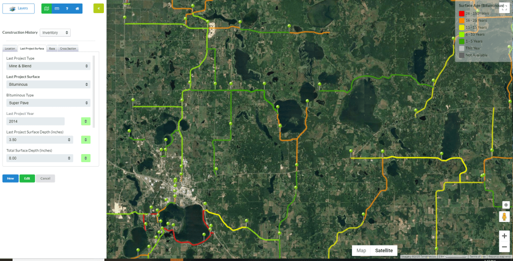
Counties enter construction planning data into GRIT, and the new module generates predictions of pavement conditions for 35 years into the future based on deterioration models and the most recent traffic and pavement condition data. The system generates performance graphs and maps of pavement condition, age, traffic and other data. When users update construction plans, the maps, graphs and projections update accordingly.
How Did We Do It?
The new forecasting model is based on an American Association of State Highway and Transportation Officials (AASHTO) structural design equation and an environmental deterioration model derived from past pavement condition ratings collected by MnDOT. While the AASHTO model required data for rigid pavements that was not available to investigators, the environmental deterioration model allows forecasting of both flexible and rigid pavement conditions.
Research team members manually processed the raw ride, roughness and pavement condition indices, and calculated the pavement quality index on a 1,000-foot interval for all Technical Advisory Panel (TAP) counties. Then they developed an automated process to spatially combine the pavement data with the GRIT construction history segments. Investigators then downloaded 2007-2015 data from the MnDOT Traffic Data and Analysis Office and sorted it for county-only information to incorporate into GRIT. An automated process based on the MnDOT State Aid load calculator was developed to project cumulative equivalent single-axle load (ESAL) loading values for 35 years into the future.
“The pavement condition forecasting model allows local agencies to show the public and county boards the condition of roads in five or 10 years if we don’t invest in them,” said Bruce Hasbargen, highway engineer, Beltrami County.
TAP members from Becker, Beltrami, Faribault, Pennington and Pope counties entered or updated inventory data into GRIT. Investigators ran models for these counties to forecast conditions, and then worked with TAP members to refine capabilities and generate road condition maps, graphs and reports.
What Was the Impact?
TAP members report that the module is effective and easy to use. County agencies with limited IT and GIS experience will be able to use the forecasting functions, and the module’s visualization and reporting capabilities will assist planning efforts and improve efficiency in managing and prioritizing projects.
The forecasting model will be fully functional in early 2020, allowing current and new GRIT users to forecast pavement condition data throughout their systems in time for 2020 presentations to county boards.
What’s Next?
Counties that want to participate must join GRIT and enter their roadway data. A webinar on the pavement forecasting tool is planned for spring 2020.
Investigators have encouraged MnDOT to develop a process for adjusting its initial gathering of pavement condition data collection to 1,000-foot intervals, which would remove a time-consuming process at UGPTI for converting MnDOT data and provide other benefits.
This post pertains to Report 2020-04, Development of Pavement Condition Forecasting for Web-Based Asset Management for County Governments, published March 2020.
