

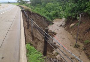
Slope failures can block roads, damage pavement and cause safety hazards. They can also be costly to repair.
For example, in June 2012, Carlton County received up to 11 inches of rain—causing flood damage and slope failures along Minnesota Highway 210. Reconstruction cost $21.3 million dollars, using federal and state emergency funds.
A recently funded research implementation project aims to help MnDOT identify areas that are susceptible to geohazards — such as landslides and rock falls— and better equip highway construction project managers to identify and mitigate risk.
Raul Velasquez, a geomechanics research engineer with MnDOT’s Office of Materials & Road Maintenance, is overseeing the study conducted by WSB & Associates.
The research team is analyzing satellite images to identify areas with geohazards. Geohazards include areas with shallow rock, sinkholes, and soft or sensitive soil. This information will then be added to map layers in Georilla—MnDOT’s internal web map application. Project managers can then pull this information during the scoping and planning phases of a construction project.
“The earlier we know about a risk, the better,” said Velasquez. “That way we can proactively mitigate the risk, or choose a different project location, if needed.”
This project builds on existing MnDOT statewide georisk modeling research. Phase 1 and Phase 2 were completed in 2019 and Phase 3 is expected to be completed by the end of August 2020.
Over the next six months, researchers will map northwest Minnesota (MnDOT District 2). Researchers will also refine and recalibrate existing maps. As slope failures occur, they will evaluate whether the tool accurately predicted the event.

While geohazard mapping is applied in other industries in Minnesota, this approach is novel among state DOTs. This exciting work can reduce risk of future road closures due to slides and sinkholes, safety hazards to the public, and puts MnDOT in a position of mitigating risk instead of reactively responding to geological emergencies.
“Avoiding high risk areas can help us reduce material loss, improve human safety, and save taxpayer dollars,” said Velasquez.
The research team presented this project at the 2020 Geo-Congress.
To request project updates or learn more, visit MnDOT’s Office of Research & Innovation.
