Tag Archives: Local Road Research Board

LRRB web tool tracks research projects around the state

As public works employees come and go, past research efforts — and the valuable knowledge gained — often goes with them.

But a recently launched web application allows users to track innovative pavement projects for a lifetime.

“It’s something everyone has always said we need to have,” said MnDOT Research Operations Engineer Jerry Geib, who worked on the project for the Minnesota Local Road Research Board.

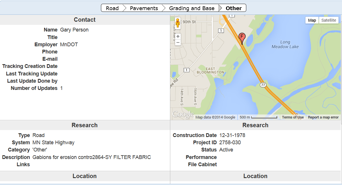
Using an online map, city and county engineers can enter road test sections that they want to observe for many years due to a particular construction method or material that was used. Too often, the knowledge about such projects is lost when a particular staff person leaves an agency.

Not only will the lessons learned be remembered within the organization, but the results can also be shared with others.

More than 1,400 projects (including some on state roads) previously identified by MnDOT have been entered into the system. Search fields allow users to look for a particular type of project anywhere in the state or they can zero the map in on a particular area of the state.

The website is still in beta form, but functional.

“It’s complete, we just want people to use it so we can improve it,” said MnDOT Research Project Engineer Melissa Cole, who began planning the site two years ago.

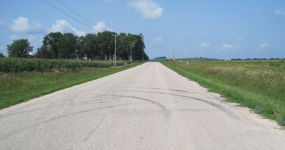
One featured project is a 1.8-mile section of dirt road in Wabasha County that had an Otta seal applied in 2007 (photo below). It is one of only a handful of lightly surfaced roads in the state (an improvement over a gravel road, but less expensive than asphalt ) so there is great interest in watching how it performs.

One of the projects being tracked is Wabasha County Road 73, one of only a couple lightly surfaced (Otta seal) roads in the state.
One of the projects being tracked is Wabasha County Road 73, one of only a handful of lightly surfaced (Otta seal) roads in the state.
More to come

The LRRB initiated the project in 2009, but it was put on the back burner for a while due to funding constraints. MnDOT ‘s technology staff began development of the current site about 11 months ago.

Anyone can look at the website, but cities and counties require permission to post projects (contact ResearchTracking.DOT@state.mn.us for credentials). They  can upload photos, plans and weblinks relating to a particular project.

“We want to track anything that is worthy of looking at a few years from now,” Geib said.

Because the website uses Google maps, users can also view archived satellite and ground-level 360-degree imagery of the roads and bridges.

The website is viewable on a tablet, but it still must be tested on smart phones. Developers hope that crews will be able to submit information right from the field.

“We’re pretty happy with it,” said MnDOT software developer John Jones. “We think we’re headed in the right direction.”

The website might eventually be expanded for other areas, such as geotechnical (foundation work), whose practitioners have already expressed an interest.

A rumble strip applied to a center line on Highway 14 near New Ulm in 2004 is being tracked.
A rumble strip applied to a center line on Highway 14 near New Ulm in 2004 is one of the projects being tracked.

Study to develop bridge load limits for tractors

Minnesota farm equipment is getting larger and heavier, causing strain on rural bridges. However, there are no  nationally recognized specifications for what size and weight of tractors can safely travel over them.

Currently, bridge load limits are based off semi-trucks, not farm machinery, which have much different axle configurations and wheel dimensions.

“Their geometry is atypical; their length, widths are different; they have different suspension characteristics,” explains Brent Phares, director of the Bridge Engineering Center at Iowa State University.

A new pooled fund study led by the state of Iowa is attempting to determine how much stress heavy farm vehicles put on bridges. This data will be used by local agencies to develop weight restrictions specifically for farm equipment.

“It will help limit the confusion of current load posting signs for farmers,” said MnDOT bridge load rating engineer Moises Dimaculangan.

Wisconsin, Minnesota, Nebraska, Oklahoma, Illinois, Kansas and the United States Department of Agriculture are also participating in the study, which is examining three types of local bridge superstructures: those with steel girders and concrete decks; bridges with steel girders and timber decks; and timber bridges with timber decks.

Through physical testing and modeling, the study will determine how different types of farm machinery distribute their loads on the bridge superstructure.

About a half-dozen farm vehicles were tested on 20 different bridges which were representative of those tending to be the most problematic for farm equipment traffic on secondary road systems, Phares said.

Instrumentation measured the response of the structures to the vehicles. This data was then used as a baseline to calibrate analytical models, which could be applied to 250 different bridges and 121 different farm vehicles.

Researchers will develop a generic tractor profile, which represents the worst-case scenario, for use in determining load limits. With the information developed, signs might be able to be added to the bridges, which show a tractor and the weight limit.Collapsed bridge

“I get a number of pictures emailed to me of bridges that have failed with a tractor implement of husbandry on top,” Phares said. “That’s the problem that people are looking to avoid; the goal isn’t to restrict the size of farm vehicles, but to develop better tools for engineers to make sound and solid analyses for the bridges, so they can provide that information to the people who need to have it.”

Phares said a couple previous studies have also looked at farm machinery weight restrictions. One study, from around 2004, took a high level look at the impact of farm vehicles on bridges. A more recent pooled fund study analyzed the impact of machinery on pavements.

Related resources

Research in Progress: Study of the Impacts of Implements of Husbandry on Bridges

The Effects of Implements of Husbandry “Farm Equipment” on Pavement Performance

Back to gravel? As dollars shrink, counties look for solutions

A large percentage of Minnesota’s local highways were built in the 1950s, the same era that birthed the modern interstate system. But the golden age of highway construction has caught up to counties, who are struggling to maintain and rehabilitate aging road systems with fewer and fewer dollars.

“Our economic resources do not meet the financial investment needed as the bulk of our pavements surfaced in the 1950s reach the end of their useful life all about the same time,” said Freeborn County Engineer Susan Miller.

In rural Otter Tail County alone, the cost of road construction has climbed 10.5 percent per year for the past 10 years.

Meanwhile, there has been only one increase in funding — an 8.5-cent bump in the state gasoline tax “that was eaten up the moment it was enacted,” said County Engineer Rick West.

Otter Tail’s funding gap? An estimated $11 million in year 2011 alone.

With no change in sight, counties across the state are banding together in a research project through the Local Road Research Board to identify ways to reduce the size of their road systems and lower preservation costs.

Forced into a corner

The LRRB launched the study at the behest of counties who were considering turning some paved highways back to gravel just to get by — even though it would probably increase long-term maintenance costs.

In addition to providing expertise on that topic, consultants worked with a group of pilot counties to develop other strategies of stretching county road dollars further. These include: changing maintenance schedules; using different gravel road materials; transferring roads to city or township ownership; adopting different road performance measures; and raising local revenue.

“This project of how five different counties approach funding limitations and how to manage a system with constrained resources is one of the best that I have been a part of through the LRRB,” said Miller, who found the data critical to convincing her county board to pass a wheelage tax.

ottertail2

A new way of thinking

Although the ideas developed through the study aren’t entirely new, for a busy county engineer with few staff, the assistance to implement them has been very valuable.

“We’re practitioners — not researchers,” said Otter Tail’s Rick West. “It’s really forced us to look at our system in its entirety and from a long-range perspective. For us, that’s huge.”

The LRRB selected pilot counties (Dakota, Otter Tail, Freeborn, Stearns and Anoka) that reflect the diversity of the state. After researchers help them implement their chosen strategies, they will hold informational workshops for others throughout the state.

“Other counties with similar roadway preservation issues or management structures can follow these best practices,” said Michael Marti of SRF Consulting Group. “There are a lot of tools out there, there just needs to be more demonstration or training on each of these tools.”

Anoka County, for example, undertook a detailed analysis to determine which roads should become city-owned and which roads the county should assume.

The evaluation system used by Anoka, which examines travel data and other factors, could be adopted by other counties.

Public education

While some ways of changing the system of road maintenance may not be immediately popular, the community will get on board if they understand why, said Otter Tail County Board Chairman Wayne Johnson.

For instance, Otter Tail had to explain why it’s more cost-effective to sealcoat four-year-old roads than reconstruct beat-up, low-volume roads.

“That’s hard to get your arms around when it’s been the other way for 50 to 60 years,” Johnson said.

Community residents did, however, reject one possible strategy discussed at eight public outreach meetings: unpaving roads.

Otter Tail’s entire county road network is paved — a reflection of investments made back in the 1950s that have become somewhat of a community ethic for Ottertail’s 57,000 residents (a population that triples during the summer).

Tools used in the study enable counties to illustrate just how far behind they are in terms of maintenance and prioritize where to make improvements.

“Everyone wants roads to be maintained, but until the road system preservation study, nobody understood the magnitude of the funding gap between where we are and what we need to do to preserve the system,” said Johnson, who recently shared his county’s findings at the National Association of County Engineers conference.

The data is critical for the public to understand why a county might seek a local tax or different method of road maintenance.

“It’s far better to try to tell them what the problem is on the front end, rather than defend the decision on the back end,” Johnson said. “We’re after them to buy into something because it’s their roads and their money.”

Resources
  •  The project findings will be completed later this year and available on the LRRB’s website.

New guidebook, training to facilitate safer pedestrian crossings

City and county engineers often struggle with how to respond to safety concerns about pedestrian crossings, with no scientific method for evaluating them.

In Long Lake, for example, the police department received numerous complaints about the safety of a particular pedestrian crossing. But when the crossing was videotaped, no one was observed using it.

This example — which was part of a research project funded by the Local Road Research Board — exemplifies the difficulties local governments face when they receive requests for a stop sign or signals at a crossing.

A pedestrian crossing control device.

A new manual and June 5 training workshop being held by the Minnesota Local Technical Assistance Program will provide cities and counties with step-by-step tools for evaluating a pedestrian crossing and identifying whether improvements are warranted.

The soon-to-be released guidebook* recommends when to install marked crosswalks and other enhancements based on the average daily vehicle count, number of pedestrians, number of lanes and average vehicle speed. It guides users how to rate a crossing for pedestrian service, and includes a flow chart to assist in decision-making.

The training is unique because it is based on actual video footage of existing crosswalks and the pedestrians which use them.

No guidance

Although vehicles are legally required to stop for pedestrians crossing at intersections and within marked crosswalks, they don’t always yield the right-of-way. And areas with high traffic volumes may not have adequate gaps for pedestrians to cross safely, leading to risk-taking.

Alan Rindels, a MnDOT research engineer, had previously looked for a methodology to evaluate a crosswalk’s effectiveness, but could not find an appropriate engineering analysis.

“What I kept coming up with were results based on the experience of an engineer or planner for what they ‘felt’ was a better crosswalk, such as additional pavement markings, lights or maybe a signal system,” he said.

Rindels finally found guidance in a Transportation Research Board webinar two years ago. Based on that, he asked the LRRB to develop a training methodology for Minnesota practitioners.

Uncontrolled pedestrian crossings

Unless specifically marked otherwise, every intersection is a pedestrian crossing, regardless of the existence of crosswalk markings or sidewalks. At mid-block locations, crosswalk markings legally establish the pedestrian crossing. Uncontrolled pedestrian crossings (which the guidebook focuses on) are locations that are not controlled by a stop sign, yield sign or traffic signal.

Defining where to place pedestrian crossing enhancements — including markings, signs and or other devices — depends on many factors, including pedestrian volume, vehicular traffic volume, sight lines and speed.

The LRRB developed a worksheet that engineers can use to evaluate an uncontrolled pedestrian crossing location in a systematic way, in accordance with the 2010 Highway Capacity Manual. Users note the level of lighting, distance from the nearest all-way stop and whether another location might serve the same pedestrian crossing more effectively.

The guidebook’s 11-step evaluation can identify what level of treatment is appropriate, ranging from overhead flashing beacons and traffic calming devices, such as curb bump-outs, to more expensive options like building overpass or underpass.

Hennepin County Senior Transportation Engineer Pete Lemke, who went through pre-training, said the guidebook will help engineers measure the pedestrian experience by “quantifying the delay at non-signalized intersections.”

“It will inform how we respond to concerns — whether that response is ‘the crossing fits the needs of what’s there’ or ‘we need to make changes or enhancements,'” he said.

Further Resources

Putting Research Into Practice: A Guide for Pedestrian Crossing Treatments at Uncontrolled Intersections – Technical Summary (1 MB, 2 pages); Final Report.

Training workshop – June 5 (register here)

* Consultant Bolton & Menks prepared the guidebook with guidance from a 21-member project team that included University of Minnesota researchers and engineers from the city of Eagan, Hennepin County, Carver County, Scott County, MnDOT, the Center for Transportation Studies and the Federal Highway Administration.

MnDOT looks for solution to noisy highway rumble strips

Rumble strips alert sleepy and inattentive motorists that they are about to veer off the highway or into the opposite lane of traffic. But the grating noise that prevents collisions can also be annoying to nearby residents.

Around Minnesota, more and more counties are facing push-back as they install shoulder rumble strips on roadways in populated areas. This is because county road shoulders are narrow — leading drivers to frequently hit the rumbles.

“There is a strong concern statewide that these noise complaints will raise enough concern that legislation may be passed reducing their use,” said technical liaison Ken Johnson of MnDOT’s Office of Traffic, Safety and Technology.

A European-developed style of rumble strip, called sinusoidal, could provide Minnesota a new means of warning drivers without as much stray highway noise.

Accident reduction

Rumble strips are patterns ground into asphalt that cause a vehicle to vibrate when its tires come close to the centerline or road edge. They help prevent lane departure crashes, which account for more than 50-percent of fatalities on the road system.

The sinusoidal rumble (below) has a sine wave pattern ground into the pavement, while the traditional rumble strip (top photo) doesn’t follow a wave pattern.

Photo courtesy of the Wirtgen Group
Creation of a Sinusoidal rumble strip. Photo courtesy of the Wirtgen Group

MnDOT’s Office of Traffic, Safety and Technology plans to test different designs of the Sinusoidal rumble strips to find the one with the highest level of interior vehicle noise and lowest level of exterior vehicle noise.

The navigability of sinusoidal rumbles by motorcycles and bicycles will also be evaluated. The project was recently funded with a research implementation grant from MnDOT’s Transportation Research Innovation Group.

If sinusoidal rumble strips are found to be effective, the chosen design will be used for centerlines and road shoulders in noise-sensitive areas throughout the state highway system. It is anticipated that counties will also adopt the design.

Unlike counties, most of MnDOT’s recent complaints have been for its centerline rumbles, which are required on all rural, high-speed undivided roads in Minnesota, Johnson said.

MnDOT has considered allowing more exceptions due to residential noise concern; however, doing so could result in more fatal and serious crashes. Sinusoidal rumbles are seen as a possible alternative for these noise-sensitive areas.

The Local Road Research Board is also studying different designs of sinusoidal rumble strips in Polk County.

New Video: “Why Aren’t They Working on My Road?”

A new video produced by the Local Road Research Board helps the public understand why some bad roads aren’t always fixed first.

The seven-minute video explains what causes road pavements to deteriorate and why, like the saying, “throwing good money after bad,”  it may be more cost-effective to put maintenance dollars into roads that still have life left in them versus roads that are in the worst condition.

In it, city and county engineers discuss how they use a pavement management program to decide which roads to fix when, in order to stretch limited resources in the most effective way possible.

“We’ve learned that if we wait for things to break and fall apart, they’re much more costly to replace than if we put a little bit into it during its life cycle,” says Mark Maloney, City of Shoreview public works director.

Three common questions about bike lanes, answered

If you’ve ever driven near a bike lane and not known what to do, you’re not alone.

A forthcoming video from the Local Road Research Board seeks to answer common questions about on-street bike lanes and help bicyclists and motorists better understand the rules. The video is due to be released this spring; in the meantime, we thought we’d give you a sneak preview by addressing three common misconceptions about bike lane rules and safety. 

1) Are bicyclists required to use a bike lane, when present?

No. Although bike lanes usually provide the smoothest, safest and most efficient method of transportation — for everybody — they are not required to use them. They are allowed to ride outside bike lanes to make turns or avoid debris, and they still have the option of using an adjacent trail where available.

2) Are vehicles allowed to enter bike lanes?

Yes, but only to park or turn onto a driveway or street. Motorists should treat bike lanes like any other lane of traffic and yield to approaching bicyclists, but they do have the right to enter bike lanes when turning.

3) Do bicyclists have to follow the same rules as motorists?

Yes. Bicycles are considered vehicles under Minnesota state law and have the same rights and responsibilities. Cyclists are required to obey stop signs and signal their turns, just like motorists.

A federal project funded 75 miles of new bike lanes in four communities, including Minneapolis.
A recent federal project funded 75 miles of new bike lanes in four communities, including the city of Minneapolis. Biking in these areas increased 50 percent; 7,700 fewer tons of carbon dioxide were emitted and gas consumption was reduced by 1.2 million gallons. (Source)

Watch for the LRRB’s new bike safety video on Crossroads this spring. In the meantime, check out MnDOT’s tips on bicycle safety.