The Minnesota Local Road Research Board recently funded a project to survey and analyze the use of Geographic Information System (GIS)-based asset management tools for city and county public works departments.
Continue reading New Project: GIS Tools and Apps – Integration with Asset ManagementTag Archives: apps

Using Smartphones to Deliver Effective In-Vehicle Work Zone Messages
Under simulated conditions, drivers were not distracted by controlled work zone-related messages delivered through smartphones. In fact, driving performance improved. Researchers also learned that the location of the smartphone did not affect the driver if the message included an auditory component.
“The main goal was to determine whether in-vehicle warnings conveyed through smartphones would be distracting to the driver. We found that wasn’t the case,” said Ken Johnson, Work Zone, Pavement Marking and Traffic Devices Engineer, MnDOT Office of Traffic, Safety and Technology.
“We learned that drivers had a lower mental workload when they experienced the in-vehicle messages. It really didn’t matter what modality we used. Half the messages were auditory only, and half were auditory paired with visual,” said Nichole Morris, Director, University of Minnesota HumanFIRST Laboratory.
What Was the Need?
Highway work zones require drivers to reduce speed and be aware of work crews, lane closures, traffic backups, construction equipment and other potential hazards on the roadway.
Transportation departments have long employed stationary warning signs, sometimes supplemented by portable changeable message signs (PCMSs), to alert drivers to upcoming construction projects. However, some previous studies have indicated that stationary warning signs are not always effective. In addition, PCMSs are costly and may be difficult to deploy in the field.
Smartphone technology offers an opportunity to deliver accurate and early in-vehicle warnings about road construction miles ahead. Digital messages could alert drivers about upcoming work zone conditions and improve safety for drivers and workers in the field.
But receiving in-vehicle messages about work zone conditions could distract drivers from safely operating their vehicles. MnDOT needed to study the advantages and disadvantages of using smart-phones to deliver in-vehicle work zone messages.
What Was Our Goal?
The primary goal of this project was to determine whether smartphones have the potential to safely deliver effective and accurate messages to drivers about upcoming road construction on Minnesota highways.
What Did We Do?

The research team developed and conducted an online survey that focused on Minnesota drivers’ perceptions of work zone safety and on their attitudes toward using smartphones and potentially receiving in-vehicle messages regarding work zone conditions.
Data from the surveys was used by the HumanFIRST Laboratory at the University of Minnesota to develop a driving simulation study designed to determine whether in-vehicle messages sent by smartphones could promote safe driving in work zones. The study analyzed 48 drivers operating a driving simulator within two work zones to test reactions to in-vehicle messages as compared to messages displayed on an external PCMS system. Researchers collected data about each participant’s visual attention, driving performance, mental workload and opinions on smartphone technology.
Researchers also reviewed previous national studies and published works to identify environmental and driver behavior risk factors related to work zones.
What Did We Learn?
An analysis of the simulation results showed drivers were very responsive to receiving in-vehicle messages regarding work zones and roadway hazards. Messages presented through smartphones did not cause driver distractions. In fact, some drivers’ performance actually improved following delivery of audiovisual messages.
Drivers preferred to receive audio messages, and researchers learned that a synthesized female voice (like Apple’s Siri) resulted in greater awareness and acceptance from the driver than a more natural or prerecorded voice.
Survey findings showed that only 5 percent of participants use a dashboard mount for their smartphones, while the vast majority keep their phone in the cup holder, on the console, in a backpack or purse, or on the passenger seat. A few participants said they hold their smartphone while driving. Investigating the safety impact of this behavior paired with an in-vehicle messaging system, researchers found that the location of the smartphone within the simulator (on the dash or passenger seat) did not negatively impact driver safety or performance, providing the work zone message contained the auditory component.
In-vehicle messages required less cognitive effort from drivers, and drivers had greater recall of the hazard warning message versus stationary PCMS signage.
A significant number of survey participants, nearly 20 percent, provided unprompted feedback that it was the state’s responsibility to provide factual work zone messaging information and to ensure in-vehicle technology employed does not pose a distraction.
What’s Next?
MnDOT will need to continue research into the viability of smartphones as the way to deliver in-vehicle work zone messages. The simulation study provided the findings needed to advance the project to field testing, where drivers would respond to in-vehicle messages from smartphones on a test track or under real roadway conditions. Another potential topic to explore through further research is the viability of messages delivered through electronic interface or dashboard features offered on some newer vehicles.
MnDOT should identify the medium needed to deliver in-vehicle messages and use the prescribed syntax outlined by the study for communicating messages. Researchers noted the existing 511 service provided by MnDOT currently provides road, traffic, weather and other information. A study should be undertaken to determine whether the 511 or a third-party app would be most appropriate for a future statewide in-vehicle messaging program.
This post pertains to Report 2017-19, “In-Vehicle Work Zone Messages,” published June 2017.

LRRB web tool tracks research projects around the state
As public works employees come and go, past research efforts — and the valuable knowledge gained — often goes with them.
But a recently launched web application allows users to track innovative pavement projects for a lifetime.
“It’s something everyone has always said we need to have,” said MnDOT Research Operations Engineer Jerry Geib, who worked on the project for the Minnesota Local Road Research Board.
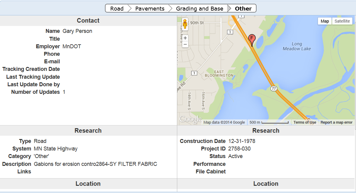
Using an online map, city and county engineers can enter road test sections that they want to observe for many years due to a particular construction method or material that was used. Too often, the knowledge about such projects is lost when a particular staff person leaves an agency.
Not only will the lessons learned be remembered within the organization, but the results can also be shared with others.
More than 1,400 projects (including some on state roads) previously identified by MnDOT have been entered into the system. Search fields allow users to look for a particular type of project anywhere in the state or they can zero the map in on a particular area of the state.
The website is still in beta form, but functional.
“It’s complete, we just want people to use it so we can improve it,” said MnDOT Research Project Engineer Melissa Cole, who began planning the site two years ago.
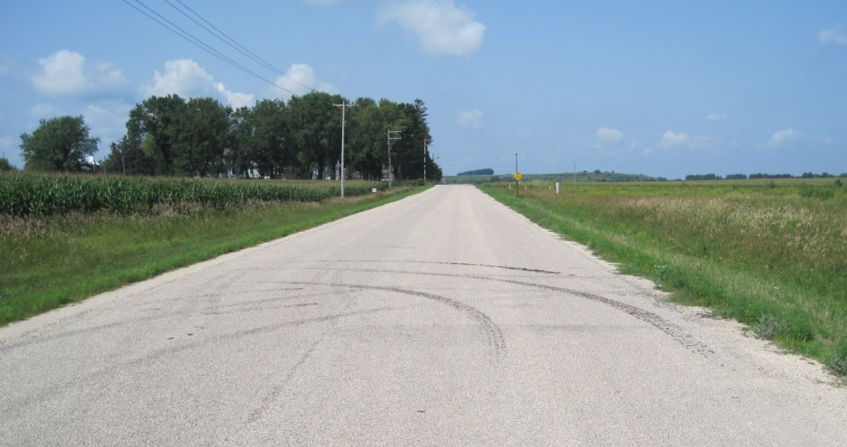
One featured project is a 1.8-mile section of dirt road in Wabasha County that had an Otta seal applied in 2007 (photo below). It is one of only a handful of lightly surfaced roads in the state (an improvement over a gravel road, but less expensive than asphalt ) so there is great interest in watching how it performs.
More to come
The LRRB initiated the project in 2009, but it was put on the back burner for a while due to funding constraints. MnDOT ‘s technology staff began development of the current site about 11 months ago.
Anyone can look at the website, but cities and counties require permission to post projects (contact ResearchTracking.DOT@state.mn.us for credentials). They can upload photos, plans and weblinks relating to a particular project.
“We want to track anything that is worthy of looking at a few years from now,” Geib said.
Because the website uses Google maps, users can also view archived satellite and ground-level 360-degree imagery of the roads and bridges.
The website is viewable on a tablet, but it still must be tested on smart phones. Developers hope that crews will be able to submit information right from the field.
“We’re pretty happy with it,” said MnDOT software developer John Jones. “We think we’re headed in the right direction.”
The website might eventually be expanded for other areas, such as geotechnical (foundation work), whose practitioners have already expressed an interest.