

Detours for highway construction projects direct heavy freight vehicles onto local roads that were not designed to accommodate the frequency of heavy loads. Detours to these local roads often accelerate pavement deterioration that shortens their service life and requires additional repair. This project examined the structural and economic impacts of detours on local roads to develop a framework for optimizing detour routes that limit pavement damage while maintaining traffic mobility.
Continue reading Limiting Pavement Damage from DetoursTag Archives: local roads

Measuring the Effects of Road Features on Driving Speeds
The Complete Streets approach to roadway design uses site characteristics to create a safer, more accessible environment for all road users. New research demonstrates that roadway design features have a measurable impact on driving speeds. The development of speed reduction factors (SRFs) that estimate the impact of road features on speed reduction provides a data-driven approach to highway design.
Continue reading Measuring the Effects of Road Features on Driving Speeds
Impacts of Lane Conversions on Level of Service
Reconfiguring roadways, also referred to as a “road diet,ˮ can be a low-cost safety solution that makes space for different travel modes in addition to motor vehicle traffic. New guidance gives local engineers an initial indication of whether a road conversion would result in a loss of capacity given the roadway motor vehicle traffic demand.
Continue reading Impacts of Lane Conversions on Level of Service
Comparing the Cost-Effectiveness of Asphalt Binders for Local Roads
Asphalt pavements with polymer-modified binders (PMBs) perform better than pavements with unmodified asphalt binders. While pavements with PMBs may cost more initially, performance is improved in the long run. In a recent study, researchers compared the performance and life cycle costs of modified and unmodified binders and found that modified binders are more cost-effective, even for local low-volume roads.
Continue reading Comparing the Cost-Effectiveness of Asphalt Binders for Local Roads
New Project: MnDOT Haul and Detour Routes – Impacts on Local Roads
When local roads are temporarily used as haul roads or as detour routes, MnDOT compensates local agencies. However, local agencies believe the compensation model is outdated and inadequate, especially for local roads not built for large volumes of heavy vehicles. The methodology also has not been updated to reflect that local agencies have invested more local property and sales tax revenue into their systems beyond the gas tax.
Continue reading New Project: MnDOT Haul and Detour Routes – Impacts on Local Roads
Pervious Concrete Pavement Reduces Runoff into Shoreview Lake
The city of Shoreview, Minnesota was on the right track when it took the unusual step of paving a residential neighborhood with pervious concrete to help control stormwater and pollutant runoff into a nearby lake, according to a recently released seven-year performance study.
Typically used for parking lots and sidewalks, porous paving material allows stormwater to filter through the pavement and an aggregate base into the soil rather than run off the pavement and drain into storm sewers.
Shoreview bucked convention by using pervious concrete in a traffic application — low-volume, low-speed roads in the Woodbridge neighborhood near Lake Owasso. The city thought pervious pavement could help meet community sustainability goals and federal clean water regulations by reducing pollutants in waterways and groundwater while keeping water safely off driving surfaces.
Traditionally, pervious concrete hadn’t been used for roadways because engineers didn’t consider it strong enough for traffic (this and other projects have now demonstrated its application for low-volume roads like neighborhood streets). The impact on ride quality, tire-pavement noise and filtration was also not well understood, particularly in cold climates with freeze-thaw cycles like those in Minnesota.
Pervious concrete also presented a maintenance challenge: Organic debris, sand and other grit can clog the pavement’s pores. Periodic vacuuming is required to maintain the intended flow of water through the pavement. Concerned about how best to maintain the pavement and interested in tire-pavement noise levels and filtering performance, Shoreview, MnDOT and the Local Road Research Board monitored the Woodbridge roadways for seven years.
Installation and Evaluation
Shoreview replaced 9,000-square -feet of asphalt roads with 7 inches of pervious concrete over 18 inches of coarse aggregate base; near the lake, highly drainable sand served as the base. About twice each year for five years, researchers tested sound absorption, water infiltration and ride quality one day after the pavement had been vacuumed. In 2015, they repeated these tests without vacuuming the day before.
The pervious pavement performed well in filtering stormwater. By 2012, at least 1.3 acre-feet of water had filtered through the pavement and ground, and by 2015, nearly 2 acre-feet of water had filtered through the surface—all of which would otherwise have run directly into Lake Owasso.
Water infiltration and sound absorption rates were higher than traditional concrete, although rates declined over time because organic material continued to clog pavement pores despite vacuuming twice a year.
Conclusions
Initial construction of the pervious concrete streets and stormwater filtration system was slightly more costly than construction of comparable asphalt pavement with culverts. Life-cycle costs, including projections of maintenance costs over 15 years, however, showed somewhat lower costs for pervious pavement. While the pervious concrete pavement may require diamond grinding after 10 years, monthly vacuuming could make this unnecessary. Asphalt pavement would typically require a mill-and-overlay at year 15, and culverts would require periodic cleaning.
Additional benefits of the pervious pavement system that were not included in cost calculations—but were clearly significant—included complying with the federal Clean Water Act, recharging groundwater and avoiding direct pollution of Lake Owasso. Shoreview’s investment in pervious concrete has paid off economically and environmentally.
For additional information about this line of research, see these resources:
- Seven-year study final report
- Technical summary of preliminary study of pervious concrete
- Related ongoing study: Permeable Pavement for Road Salt Reduction

County GIS Maps Help Road Departments Anticipate Slope Failure
In a recently completed pilot study, researchers developed maps for two Minnesota counties that rank the failure potential of every slope using a geographic information system (GIS)-based model.
“GIS mapping has been applied to very small watersheds. The two counties in this study are huge areas in comparison. We used a physics-based approach that shows engineers where slope failure is likely to occur,” said Omid Mohseni, Senior Water Resources Manager, Barr Engineering Company.
What Was Our Goal?
The goal of this study was to determine if slope failure models could be developed to help counties anticipate where failures may occur. Researchers used publicly available data, research findings and geotechnical theory to develop failure models that could then be mapped with GIS in two topographically dissimilar Minnesota counties. These maps would identify slopes susceptible to failure so that county highway departments could develop preventive strategies for protecting roadways from potential lope failure or prepare appropriate failure response plans.
What Did We Do?
Researchers began with a literature review of studies about the causes of slope failure, predictive approaches and mapping. They were particularly interested in research related to potential failure mechanisms, algorithms used for predicting failures and slope-failure susceptibility mapping.
Then investigators collected data on known slope failures in Carlton County in eastern Minnesota and Sibley County in south central Minnesota to identify failure-risk factors not found in the literature. Researchers reviewed various statewide data sets, identifying topographic, hydrologic and soils information that could be used in GIS-based modeling. Next, they developed a GIS-based slope-failure model by incorporating the available data with geotechnical theory and probability factors from hydrologic data, and writing computer code to allow the data to be input into mapping software.
Researchers tested the software on known failure sites to refine soil parameter selection and failure models. The refined models and software were then used to identify and map slope failure risks in Carlton and Sibley counties.

What Did We Learn?
After analyzing the literature and the failure and geotechnical data, researchers identified the following key causal factors in slope failure: slope angle, soil type and geology, vegetation, land use and drainage characteristics, soil moisture, and rainfall intensity and duration.
Researchers then developed mapping models for the two counties using three key data sets. The first was data from 3-meter resolution, high-quality lidar, which measures distances with laser range finders and reflected light, available through Minnesota’s Department of Natural Resources website. The team augmented this data with U.S. Department of Agriculture soils survey data, and with National Oceanic and Atmospheric Administration and National Weather Service hydrologic data for precipitation and storm duration information.
Based on research in geotechnical theory, researchers developed algorithms for anticipating failure and built these into the lidar-based topographic mapping model. They also developed input parameters based on the failure factors and established output parameters representing five levels of failure susceptibility: very low, low, moderate, high and very high.
After testing the GIS-based model against a slope along County Highway 210 in Carlton County, researchers confirmed that failure potential correlated well with documented or observed slope failure. The team further validated the model by applying it to several small areas in the adjacent Carver and Sibley counties, finding similarly effective correlation with identifiable failure sites.
Independent geotechnical experts examined the modeling software and further refined geotechnical, soil and hydrologic elements. Finally, the team developed maps of Carlton and Sibley counties that assigned failure susceptibility levels to slopes in the two counties. Viewing maps through the software remains the most useful way to examine slopes, although large-format maps are available.
“If county engineers have higher slopes adjacent to roadways, they can use this basic tool to predict slope failures and then hire a geotechnical consultant to investigate the site.” – Tim Becker, Public Works Director, Sibley County
What’s Next?
With additional funding, mapping could be extended to every county in Minnesota to further refine failure modeling. Maps may also be useful in identifying structures such as roadways, ecological features, transmission lines and pipelines, bridges and culverts that may be threatened by slope failure susceptibility. Potential risks could be used to prioritize slope treatment plans.
This research effort is part of a slope failure risk mitigation strategy that includes the recently released Slope Stabilization Guide for Minnesota Local Government Engineers. Another project, underway at MnDOT, is identifying, mapping and ranking slopes vulnerable to slides that could affect the state highway network. The project
This post pertains to the Local Road Research Board-produced Report 2018-05, “Storm-Induced Slope Failure Susceptibility Mapping,” published January 2018. More information is available on the project page.

Using a National Database to Develop Performance Metrics for Local Pavement Markings
Pavement marking performance metrics from a new study will help Minnesota local agencies save time and money by choosing longer-lasting pavement marking products.
Researchers developed pavement marking performance metrics for Minnesota local agencies to use as a guide to make better pavement marking product decisions. The metrics were developed based on an analysis of survey data collected from Minnesota local agencies and MnDOT pavement marking data mined from the National Transportation Product Evaluation Program (NTPEP). Findings showed differences in product performance with regard to retroreflectivity and service life, which were impacted by variables such as road surface type, year of application, traffic volume and type of pavement marking.
“There would be great potential savings in using pavement marking products with a longer service life. Mining NTPEP data to analyze product performance has not been done before and should contribute substantially to this goal,” said Omar Smadi, Director, Iowa State University Center for Transportation Research and Education.
What Was Our Goal?
The goal of this research was to develop pavement marking performance metrics for Minnesota local agencies to use as a guide when choosing the most durable and cost-effective products. Researchers developed the pavement marking performance metrics, specifically for retroreflectivity and service life, by analyzing existing MnDOT data mined from NTPEP. They also used the findings to make recommendations for future pavement marking research to support local agency needs.
What Did We Do?
Researchers designed and conducted a survey to assess pavement marking products used by local agencies in the state. Then they extracted 2010 and 2013 MnDOT pavement marking data from NTPEP to analyze the performance of products that survey respondents identified as commonly used.
NTPEP data included products tested at two different sites and applied on different road surfaces. Researchers analyzed performance with regard to retroreflectivity and deterioration or longevity of the materials under various conditions, such as road surface type, year of application, traffic volume and type of pavement marking. Based on results from the analysis, researchers developed performance metrics for Minnesota local agencies to use as a guide for choosing particular pavement marking product types.
What Did We Learn?
From the survey results, researchers learned that the majority of Minnesota local agencies use either latex or epoxy as their primary pavement marking material. However, epoxy and tape outperformed latex at all levels of conditions and provided a service life of three years or more.
A few survey respondents also reported grooving as a method that seemed to extend the service life of latex paint markings. Researchers were unable to investigate the impact of grooving, however, since MnDOT grooving data was not accessible.

From the NTPEP data analysis, researchers concluded the following:
- White markings had significantly higher initial retroreflectivity and slower deterioration than yellow markings.
- Road surface type does not significantly impact retroreflectivity throughout its service life.
- Epoxy has higher retroreflectivity than latex materials.
- As expected, markings on wheel zones deteriorated faster, reducing retroreflectivity over time.
- Deterioration values of markings varied among different test sites, which may be attributed to differences in average annual daily traffic (AADT) values (10,000 in 2010 versus 37,000 in 2013) or installation practices.
“The findings from this research will be beneficial for Minnesota local agencies in determining which pavement marking materials are most effective,” said Kate Miner, then-Scott County Traffic Manager.
What’s Next?
Although the product performance metrics data will help Minnesota local agencies make better pavement marking product decisions in less time, researchers recommend developing a guidebook to make the information more usable. Adding grooving data to the guidebook would also be beneficial to investigate the potential impact grooving provides in extending the service life of pavement markings.
Researchers also recommend testing the same products evaluated in this research on low-volume local roads and on challenging surface types. MnDOT NTPEP data only included products that were tested on high-volume freeways.
This blog pertains to the Local Road Research Board-produced Report 2017-43, “Minnesota Local Agency Pavement Marking: Mining Existing Data,” published November 2017. A related project has developed a spreadsheet tool to help local agencies prioritize pavement markings on low-volume roads.

A Look at Local Bridge Removal Practices and Policies
Many local agencies in Minnesota lack funding to construct and maintain all the bridges in their roadway network. One way to lower costs is to reduce the number of bridges.
In Minnesota, some township bridges are on roads with low usage that have alternative accesses for nearby residents, but local officials are reluctant to remove the bridges.
To identify possible changes to how redundant and low-use bridges are identified and removed in Minnesota, the Local Road Research Board conducted a transportation research synthesis, “Local Bridge Removal Policies and Programs,” that explores how other states make bridge removal decisions.
Fifteen state DOTs responded to a survey about their processes, with varying levels of state oversight identified for bridge removal decisions. Researchers also examined funding and incentives offered by some DOTs to local agencies for bridge removal, as well as criteria for considering bridge removal.
A literature search of bridge design manuals, inspection manuals and bridge programs was also conducted to identify related policies and programs.
Read the TRS to learn more about the various bridge removal policies and procedures in place in Minnesota and other states.

Back to gravel? As dollars shrink, counties look for solutions
A large percentage of Minnesota’s local highways were built in the 1950s, the same era that birthed the modern interstate system. But the golden age of highway construction has caught up to counties, who are struggling to maintain and rehabilitate aging road systems with fewer and fewer dollars.
“Our economic resources do not meet the financial investment needed as the bulk of our pavements surfaced in the 1950s reach the end of their useful life all about the same time,” said Freeborn County Engineer Susan Miller.
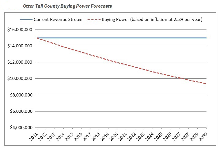
In rural Otter Tail County alone, the cost of road construction has climbed 10.5 percent per year for the past 10 years.
Meanwhile, there has been only one increase in funding — an 8.5-cent bump in the state gasoline tax “that was eaten up the moment it was enacted,” said County Engineer Rick West.
Otter Tail’s funding gap? An estimated $11 million in year 2011 alone.
With no change in sight, counties across the state are banding together in a research project through the Local Road Research Board to identify ways to reduce the size of their road systems and lower preservation costs.
Forced into a corner
The LRRB launched the study at the behest of counties who were considering turning some paved highways back to gravel just to get by — even though it would probably increase long-term maintenance costs.
In addition to providing expertise on that topic, consultants worked with a group of pilot counties to develop other strategies of stretching county road dollars further. These include: changing maintenance schedules; using different gravel road materials; transferring roads to city or township ownership; adopting different road performance measures; and raising local revenue.
“This project of how five different counties approach funding limitations and how to manage a system with constrained resources is one of the best that I have been a part of through the LRRB,” said Miller, who found the data critical to convincing her county board to pass a wheelage tax.
A new way of thinking
Although the ideas developed through the study aren’t entirely new, for a busy county engineer with few staff, the assistance to implement them has been very valuable.
“We’re practitioners — not researchers,” said Otter Tail’s Rick West. “It’s really forced us to look at our system in its entirety and from a long-range perspective. For us, that’s huge.”
The LRRB selected pilot counties (Dakota, Otter Tail, Freeborn, Stearns and Anoka) that reflect the diversity of the state. After researchers help them implement their chosen strategies, they will hold informational workshops for others throughout the state.
“Other counties with similar roadway preservation issues or management structures can follow these best practices,” said Michael Marti of SRF Consulting Group. “There are a lot of tools out there, there just needs to be more demonstration or training on each of these tools.”
Anoka County, for example, undertook a detailed analysis to determine which roads should become city-owned and which roads the county should assume.
The evaluation system used by Anoka, which examines travel data and other factors, could be adopted by other counties.
Public education
While some ways of changing the system of road maintenance may not be immediately popular, the community will get on board if they understand why, said Otter Tail County Board Chairman Wayne Johnson.
For instance, Otter Tail had to explain why it’s more cost-effective to sealcoat four-year-old roads than reconstruct beat-up, low-volume roads.
“That’s hard to get your arms around when it’s been the other way for 50 to 60 years,” Johnson said.
Community residents did, however, reject one possible strategy discussed at eight public outreach meetings: unpaving roads.
Otter Tail’s entire county road network is paved — a reflection of investments made back in the 1950s that have become somewhat of a community ethic for Ottertail’s 57,000 residents (a population that triples during the summer).
Tools used in the study enable counties to illustrate just how far behind they are in terms of maintenance and prioritize where to make improvements.
“Everyone wants roads to be maintained, but until the road system preservation study, nobody understood the magnitude of the funding gap between where we are and what we need to do to preserve the system,” said Johnson, who recently shared his county’s findings at the National Association of County Engineers conference.
The data is critical for the public to understand why a county might seek a local tax or different method of road maintenance.
“It’s far better to try to tell them what the problem is on the front end, rather than defend the decision on the back end,” Johnson said. “We’re after them to buy into something because it’s their roads and their money.”
Resources
- The project findings will be completed later this year and available on the LRRB’s website.
