

Improving the rates of drivers yielding to pedestrians has been challenging despite crosswalk laws. Expanding on an earlier study, researchers further explored the effectiveness of engineering treatments at road crossings, giving agencies a deeper understanding of how to maximize pedestrian safety.
Continue reading Improving Driver Yielding to Pedestrians at IntersectionsTag Archives: multimodal

Alternative Transit Approaches for Rural Communities
Meeting transit needs in rural communities can be challenging. A new pilot study demonstrated the benefits of using mobile technologies and existing assets to enhance transit services and improve local economies.
Continue reading Alternative Transit Approaches for Rural Communities
Short Films, Big Visions: Transportation-themed films spark conversation about community connections
April 4, 2023
Dozens of community members and transportation advocates tuned in to “Short Films, Big Visions: A Series on Transportation and Community” on February 23. Co-hosted by CTS and the Humphrey School of Public Affairs, the virtual event featured a screening of short films produced by the Redford Center for its “Community Power” series followed by an engaging panel discussion.
Continue reading Short Films, Big Visions: Transportation-themed films spark conversation about community connections
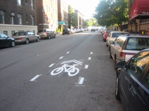
Clearly Marked Bicycle Lanes Enhance Safety and Traffic Flow
Researchers evaluated bicycle and motor vehicle interactions at nine locations in Duluth, Mankato, Minneapolis and St. Paul,in a study sponsored by the Minnesota Local Road Research Board to better understand how bicycle facilities affect traffic. Results show that on shared roadways without clearly marked bicycle facilities, drivers are more inclined to pass bicyclists, encroach on other traffic lanes or line up behind bicyclists than on roadways with clearly striped or buffered facilities.
“This project gave us qualitative information and some quantitative information. The observations made provide something we can build on,” said James Rosenow, Design Flexibility Engineer, MnDOT Office of Project Management & Technical Support.
“The solid line makes the absolute difference in bicycle facilities— something that we haven’t seen in any other study. We found that the presence of a clearly marked or buffered bicycle lane makes a large difference in the way drivers behave around bicyclists,” said John Hourdos, Director, Minnesota Traffic Observatory, University of Minnesota.
What Was the Need?
The availability of multimodal traffic facilities encourages travelers to use a range of transportation methods, from driving to riding on public transit and bicycling. Although bicycle use is low compared to motor vehicle and public transit use, MnDOT’s Complete Streets program encourages cities and counties to dedicate roadway space to bicycle facilities to expand transportation options and “maximize the health of our people, economy and environment.”
Planners and engineers typically consider bicycle facilities from the bicyclist’s perspective. It is less common to design and plan for bicycle use from the driver’s perspective. However, effective multimodal planning requires an understanding of how bicycles affect traffic if congestion-causing interactions are to be avoided, particularly on high-volume roads. Bicycle facilities must invite use, ensure safety for all road users and at the same time not slow traffic.
What Was Our Goal?
This project aimed to investigate interactions between drivers and bicyclists on urban roadways that employ various bicycle facility designs, and to determine how different bicycle facilities affect traffic. Researchers sought to look at bicycle facilities from the driver’s point of view.
What Did We Do?
The investigation team reviewed 44 bicycle facility design manuals and guidance documents, 31 research papers on implementation or assessment of facility designs, and design manuals used by seven other Complete Streets programs from around the United States to identify facility designs that warranted further study.
With help from the MnDOT Technical Advisory Panel and local planners, the team selected nine sites in Duluth, Mankato, Minneapolis and St. Paul that offered a range of facilities—buffered bicycle lanes, striped bicycle lanes, sharrows (shared-use arrows), signed shared lanes and shoulders of various widths.
At each site, they set up one to three cameras and videotaped during daylight hours for five to 51 days. Researchers then trimmed the video data into relevant car-and-bicycle-interaction time frames. This yielded from 16 to 307 hours of video from each site for detailed analysis.
The research team then reviewed the video and analyzed how drivers behaved when encountering bicyclists on roads with and without bicycling facilities. Researchers grouped driver behavior into five categories: no change in trajectory, deviation within lane, encroachment on adjacent lane, completion of full passing maneuver and queuing behind bicyclists. Researchers confirmed their observations with statistical modeling. After analyzing the results of behavior as it correlated with facility type, researchers presented the traffic flow implications of different bicycle facility designs.
What Did We Learn?
- Literature Review. Almost all design guidance drew heavily on directives from the American Association of State Highway and Transportation Officials or the National Association of City Transportation Officials. Of the 62 bicycle facility design elements identified in bicycle guidance documents, fewer than half have been studied in any way for efficacy, safety or traffic impact.
- Video Analysis. On roadways with sharrows, signs for shared lanes or no bicycle facilities, drivers were more likely to encroach on adjacent lanes than were drivers on road-ways with buffered or striped bicycle lanes. Queuing, or lining up behind bicyclists, showed the greatest potential to impact traffic flows. The highest rates of lining up occurred on roads without bicycle facilities and roads with shared facilities but no marked lanes.
- Implications. Sharrows may alert drivers to the presence of bicyclists, but in the impact they make on traffic, sharrows differ little from no bicycle facilities. Roadways with signs indicating shared lanes also show little difference in driver behavior from roadways with no facilities. Therefore, where space allows, buffered or striped bicycle lanes should be used instead of sharrows or signs to increase the predictability of driver behavior and reduce queuing impacts on traffic.
What’s Next?
This study provides enough data to support the recommendation of dedicated, striped or buffered bicycle facilities where demand or interest exists. However, the detailed video analysis conducted for this project provides only part of a three-dimensional study of the efficacy and value of various bicycle facility designs. Further study will be needed to quantify facility and vehicle-bicycle interaction in terms of other traffic impacts like speed and traffic flow coefficients, and to quantify crash rates and other safety impacts. Research is also needed to investigate bicycle facility demand and bicycle use on road-ways that do not currently have bicycle facilities.
This post pertains to the LRRB-produced Report 2017-23, “Traffic Impacts of Bicycle Facilities,” published June 2017.

Project seeks to ease traffic congestion in a roundabout way
Freeways and highways aren’t the only urban roads with traffic congestion, even though traffic management strategies have been largely directed toward improving traffic flows there. So, U of M researchers have taken to city streets to reduce congestion in an innovative—albeit roundabout—way.
“There’s been a lot of research focused on controlling congestion on major highways and freeways, but there’s relatively less when it comes to looking at controlling traffic on urban arterials,” says Ted Morris, a research engineer with the Department of Computer Science. “It’s a very different picture when you get into urban arterials and the traffic behaviors going on there, because of the dynamics of route choice, pedestrian interactions, and other factors.”
Morris is part of a research team that aims to create a framework for testing and evaluating new urban traffic sensing and control strategies for arterial networks. The goal is to balance safety and efficiency for all users—especially in places where new types of urban transportation facilities are planned in the next few years.
The team is using the 66th Street corridor in Richfield as a test bed for its research. The city, along with Hennepin County, is in the process of converting a series of signalized intersections along the route to roundabouts over the next few years. The roundabout designs also incorporate new facilities for pedestrians, bikes, and bus transit as part of a multimodal approach.
Initially, the researchers sought to create a larger network of interconnected sensors and a live test bed, Morris says. But funding limitations kept the project area to approximately 10 miles of arterial roads, a portion of which will be supported by a network of interconnected traffic sensors. The research team is instrumenting major intersections along 66th Street with a reliable, low-cost, high-resolution camera mounted on a center pole and supporting electronics as the intersections are being reconstructed.
“You can zoom in pretty closely to capture all the different movements and events that we need to use for measurement and detection,” Morris adds. “The key to this, to really make it reliable, is you need to very carefully quantify gap acceptance and how that varies in time and time of day. You also need to know how pedestrian activities interact with the traffic flow.”
The use of roundabouts has grown in the region because they cost less to build and maintain than signalized intersections, they meet the latest design standards, and they improve safety by reducing traffic conflicts. But predicting the capacity of roundabouts can be especially challenging when factoring in pedestrian traffic, uneven traffic origin-destination flow, heavy vehicle volumes, and approach vehicle gap-selection timing.
In addition to creating a sensor network to obtain real-time vehicle and pedestrian data to help control traffic and keep it flowing smoothly, the researchers also are developing a traffic simulation model that includes almost all of Richfield—more than 140 signalized intersections covering 21 square miles, including the arterials. The simulation model will be used to develop and test traffic control strategies under different scenarios. Minnesota Traffic Observatory director John Hourdos is leading that effort.
This research and the field deployment system are funded through a collaborative grant from the National Science Foundation Cyber Physical Systems program. SRF Consulting is the industrial partner to help design the sensor network and evaluate the system.

Six Ways to do Multimodal in Greater Minnesota
Can rural Minnesota do multimodal?
You betcha, says a new study by University of Minnesota researcher Carol Becker, who compiled 65 examples of innovative multimodal rural and small urban transportation projects from around the United States.
The study, funded by the Minnesota Department of Transportation, looks at alternatives for promoting and strengthening multimodal transportation in rural and small urban areas. Becker developed these six case studies to showcase different modes and strategies:
Retrofitting Sidewalks
The city of Olympia, Washington, was mostly built during the automobile era. As a result, most of the city developed without sidewalks. In 2004, Olympia passed a voter referendum that linked enhanced parks with adding sidewalks throughout the city. The referendum was supported by parents who wanted safe routes to school for their children and by environmentalists who wanted alternatives to driving. But the key to voter approval was linking recreation at parks with recreation walking to and from the parks. The Parks and Pathways program is now retrofitting miles of sidewalks into neighborhoods.

Intercity Bus Service
North Dakota has the third-lowest population density in the United States. Despite this, it has a network of buses that connect small towns to larger regional centers. Such alternatives to driving allow residents — particularly elderly and disabled persons — to stay in their communities rather than move to large cities to access needed services.
Senior Transportation
A nonprofit in Mesa, Arizona, implemented a program to reimburse eligible seniors for car trips provided by other individuals. The program was moved to the regional transit provider for expansion. It did not scale up well, however, and was recently replaced with the East Valley RideChoice Program, which provides seniors and disabled adults with discounted cards for taxi service. RideChoice participants can receive up to $100 of taxi service per month for either $25 or $30, depending on their city of residence.

Integrating Highways into Small Town Fabric
One challenge to making smaller communities more walkable and pedestrian-friendly is that most small towns are built around 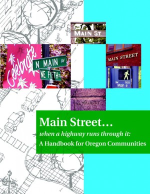 highways. In fact, unless a bypass has been built, the main street of a small town is also typically a highway. This creates a conflict between groups who want to move vehicles efficiently and groups who want pedestrian-friendly downtowns.
Oregon took two steps to help mediate this:
- Added a functional classification to the Oregon Highway Manual for the portion of roadway that runs through small towns. This functional classification has very different design standards that can accommodate walking, biking, commercial activity along the roadway, parking along the roadway and many other small-town needs.
- “Main Street: When A Highway Runs Through It” was written to help local governments understand their options for creating a multimodal environment and better advocate for their interests with the Oregon Department of Transportation. The document explains ODOT funding processes and shows examples of design options. Local governments can then adopt these elements and standards into their local plans, which ODOT must work with when doing highway improvements.
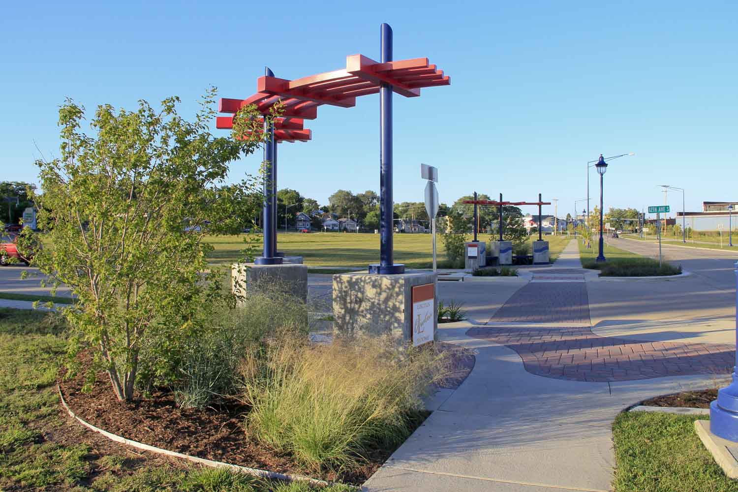
Complete Streets
Clinton, Iowa, is a city with a population of 27,000 on the Mississippi River in eastern Iowa. In 1995, the rail yard closed, which provided an opportunity to redevelop land. The city created a comprehensive long-range plan that included remediating soil contamination, purchasing land for redevelopment, realigning two streets and increasing transportation choices with a “complete streets” design. The reclaimed land will support a multi-use path, sidewalks and connections to cross streets.
Approximately $50 million has been secured for the project. A $2.7 million Transportation Investment Generating Economic Recovery (TIGER) grant was also received from the U.S. Department of Transportation in 2012 to pay for a multi-use trail with a direct connection to the Mississippi River Trail, decorative lighting and plantings. In the future, land will be sold for higher density, walkable development.
Impact Fees for Funding Infrastructure
As resistance increases to broad-based taxes, there has been a shift toward funding transportation with fees linked to specific projects. Examples include:
- Concurrency laws, which require capacity in governmental systems (either planned or existing) before development can occur. If capacity does not exist, development cannot occur. In the state of Washington, a number of cities use concurrency to set transportation fees paid by new development. Bellingham, Washington, uses this kind of system to raise funds for transportation projects.
- Development impact fees. Contra Costa County, California, has a capital plan for transportation improvements and sets a fee that is paid by new development to fund that infrastructure. Fees vary from under $1,000 to over $15,000 depending on where new development is occurring. The county expects to raise more than $845 million in transportation dollars from 2014 to 2030 using such a mechanism.
- Allowing local units of government to create special districts to fund transportation projects.
Related Resources
Rural and Small Urban Multi-Modal Alternatives for Minnesota – Final Report

Video: Minnesota Statewide Bicycle Plan

Bicycle and pedestrian-counting project wins CTS partnership award
(Feature image courtesy Michael McCarthy, Center for Transportation Studies.)
Earlier this year, we wrote about the Minnesota Bicycle and Pedestrian Counting Initiative, a project that developed guidelines and protocols to help transportation planners accurately count non-motorized traffic. This groundbreaking research involved a diverse partnership of state and local officials, University of Minnesota faculty, and private and nonprofit organizations.
On Wednesday, April 23, the project team (photo above) was honored with an award from the Center for Transportation Studies. Team members accepted the CTS Research Partnership Award in a ceremony at the McNamara Alumni Center in Minneapolis. The award is given each year to projects that have resulted in “significant impacts on transportation” and that draw on “the strengths of their diverse partnerships” to achieve their results.
The video below, produced by CTS, explains the importance of the project. MnDOT is now in the process of implementing the research results by installing permanent counters and using portable counters in select locations around the state. MnDOT plans to use the information for a variety of purposes, including planning, safety analysis, investment planning and quality-of-life analysis.
Project team members will present their research findings at the North American Travel Monitoring Exposition and Conference in July. The conference’s focus is on “Improving Traffic Data Collection, Analysis, and Use.”
*Bonus: Read about last year’s Research Partnership Award-winner, a MnDOT-led, multi-state effort to reduce low-temperature cracking in asphalt pavements.
Learn more about the project:
- Technical Summary (PDF)
- Final Report (PDF)

New Roadway Safety Institute focuses on user-centered solutions for multiple modes
The new Roadway Safety Institute, a $10.4 million regional University Transportation Center (UTC) established in late 2013, will conduct a range of research, education, and technology transfer initiatives related to transportation safety. Led by the University of Minnesota, the two-year consortium will develop and implement user-centered safety solutions across multiple modes.
The Institute will be a focal point for safety-related work in the region, which includes Minnesota, Illinois, Indiana, Michigan, Ohio, and Wisconsin. Other consortium members are the University of Akron, University of Illinois at Urbana-Champaign, Southern Illinois University Edwardsville, and Western Michigan University.
Max Donath, professor of mechanical engineering at the U of M, serves as the new Institute’s director. In this month’s issue of the CTS newsletter, Catalyst, Donath shared his vision for the Institute.
According to Donath, the Institute will focus on addressing regional traffic safety priorities, educating the public, and attracting more professionals to the safety workforce by connecting with students.
Research topics will focus on two key areas, Donath said: high-risk road users and traffic safety system approaches. The goal of this work is to prevent the crashes that lead to fatalities and injuries on the region’s roads.
One unique Institute effort will involve working with American Indian communities in the region to explore and address the unusually high number of motor vehicle crash fatalities on tribal lands. “Our research will work to better understand why this is happening and to develop more effective solutions,” Donath said.
Read the full Q&A in the April issue of Catalyst.

Minnesota Bike Lanes: Learning to Share the Road
