Tag Archives: safety

MnDOT Tests Crowdsourcing to Improve Road Condition Reporting

The Minnesota Department of Transportation is testing a crowdsourcing application that will allow motorists to update winter weather road conditions on the state’s 511 system.

The Regional Transportation Management Center is planning a soft launch of Citizen Reporting in April, initially inviting MnDOT employees to post their experiences on routes they travel.  By next winter, the RTMC hopes to invite the public to do the same.

“We suspect that citizen reporters will be similar in ethic to the kinds of people who volunteer to be weather spotters,” said MnDOT Transportation Program Specialist Mary Meinert, who assists with day-to-day operations of 511.

511 Citizen Reporting
Iowa launched Citizen Reporting in November. Here is an example of a citizen report.

Currently,  MnDOT maintenance crews report road conditions, but Greater Minnesota lacks 24/7 coverage and its reports can become quickly outdated, especially on highways that aren’t plowed as frequently or lack traffic cameras, said 511 System Coordinator Kelly Kennedy Braunig.

Citizen reporting, especially on weekends, will help keep that information fresh.

“We try to explain on the website that we only update from 3–6 a.m., 3–6 p.m. Monday through Friday and as road conditions change, but we still get many emails requesting more frequent road condition information,” Braunig said.

Even a recent comment on MnDOT’s Facebook page pointed out the limitations in one area of the state: “Updates [only] come during government work hours.”

Growing Service

It’s actually a welcome sign that the public wants more from 511.

Seven years ago, when Braunig applied for her job, not many people used 511. In fact, at the time, she wasn’t even aware of the service, which provides information to travelers on weather-related road conditions, construction and congestion.

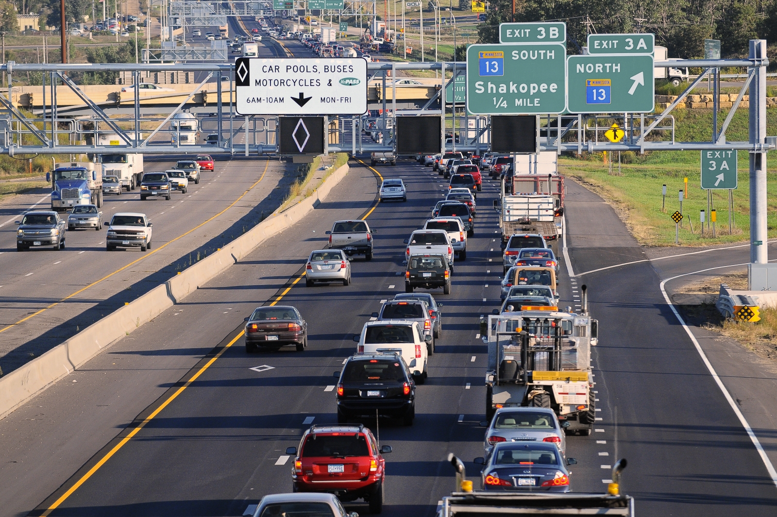
Today, 511’s online program and mobile app are accessed by more than 5,000 people per day during the winter (and about half as many during the summer). Data comes from MnDOT’s construction and maintenance offices, as well as state trooper data and incident response. This real-time information is available for all of Minnesota.

In the Twin Cities metro area, more than 700 traffic cameras allow MnDOT and State Patrol dispatchers to check the condition of 170 miles of highways and monitor traffic incidents at any time. Rochester, Duluth, Mankato and Owatonna also have cameras for incident management and traffic monitoring.

The 511 system’s greatest challenge is in Greater Minnesota, where road condition information is used daily by schools, ambulance personnel and truckers, as well as the traveling public, but information isn’t updated frequently outside of business hours.  Citizen reporting will be a beneficial resource.

Other states

Other northern states face similar challenges as Minnesota, but have been able to improve the timeliness of road condition data with assistance from truckers and other motorists.

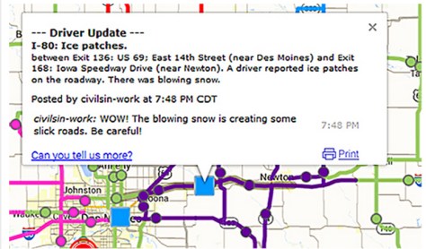
In Wyoming, more than 400 citizen reporters (primarily truckers) call in road conditions to the Transportation Management Center. In Idaho, citizen reporters directly put the information into the 511 system. Minnesota will be the fifth state to adopt citizen reporting, following Iowa, which launched its service in November 2014.

Like Iowa, Minnesota’s citizen reporting will initially focus on winter roads.

To participate, people will need to take an online training module and then register their common routes, perhaps the highways they take to work or their way to the cabin on the weekends. These contributions will be marked as a citizen report on the website.

“Minnesota truck drivers are loyal users of the 511 system and we suspect they will also make some of our best reporters,” Meinert said.

Minnesota is part of a 13-state consortium that shares a 511 service technology provider. States with citizen reporting recently shared their experiences in a Peer Exchange sponsored by North/West Passage, a transportation pooled fund that is developing ways to share 511 data across state lines.

“With citizen reporting we hope to give people a voice and a chance to participate,” Braunig said.

Winter seminars highlight research on work-zone safety, culvert design, and more

Join us in person on the U of M campus or tune in online to the CTS winter research seminars. The seminars will highlight a sampling of the latest transportation research at the U of M.

Here’s this year’s seminar schedule:

Each seminar will be held in Room 50B at the Humphrey School of Public Affairs. Or, if you can’t make it in person, you can watch the seminars live online or view recordings posted after the events. For details about the live broadcasts, see the individual seminar web pages.

There’s no cost to attend, and each seminar qualifies for one Professional Development Hour.

Hope to see you there!

New permitted left-turn model helps improve intersection safety

In recent years, the transportation community has introduced significant changes to improve left-turn safety at signalized intersections—and for good reason. Nationally, intersection crashes represent one-fifth of all fatal crashes, and most of these are crashes involving left turns.

In response to this serious safety problem, the FHWA has adopted a new national standard for permissive left turns: the flashing yellow arrow. This signal warns drivers that they should proceed with a left turn only after yielding to any oncoming traffic or pedestrians. Flashing yellow arrow signals can help prevent crashes, move more traffic through an intersection, and provide additional traffic management flexibility.

Many transportation agencies, including MnDOT, are interested in using the new flashing yellow arrow signals to accommodate within-day changes: protected left turns (signaled by a green arrow) could be used when needed to lower crash risk, while permitted left turns (signaled by a flashing yellow arrow) could be used to reduce delay when crash risk is low.

“Of course, this requires being able to predict how the risk of left-turn crashes changes as intersection and traffic characteristics change within the course of a day,” says Gary Davis, a professor of civil, environmental, and geo- engineering at the University of Minnesota.

To help engineers make more informed decisions about when to use flashing yellow arrows, Davis is leading the development of a model that could help predict the probability of left-turn crash risk at a given intersection at different times of day. This model—which will ultimately be available as a set of spreadsheet tools—will help traffic engineers determine when the crash risk is sufficiently low to allow for the safe use of flashing yellow arrows. The project is sponsored by MnDOT and the Minnesota Local Road Research Board.

To develop the statistical model, the researchers needed to determine how the risk for left-turn crashes varies depending on time of day, traffic flow conditions, and intersection features (such as number of opposing lanes, number of left-turn lanes, and median size). The process included developing a database containing left-turn crash information, intersection features, and traffic volumes, as well as developing a set of 24-hour traffic pattern estimates to help fill gaps where hourly traffic volume counts were not available. The resulting statistical model uses this information to determine relative crash risk for every hour of the day at a given type of intersection.

Currently, Davis and his team are using the model to develop a spreadsheet tool that will allow traffic engineers to choose their type of intersection and enter the available turning movement count. The tool will then generate a specialized graph for that intersection showing the relative crash risk by time of day. Any time the crash risk is at or below the level identified as acceptable, engineers can consider using flashing yellow arrows.

“By simulating how crash risk changes as traffic conditions change, this model could help identify conditions when permitted left-turn treatments would be a good choice and what times of day a protected left turn might be a better option,” Davis says.

Moving forward, Davis is leading an additional project related to the use of flashing yellow arrows, funded by the Roadway Safety Institute. The project will first review video data of drivers making permitted left turns to characterize left-turn gap acceptance and turning trajectories. Then, Davis will incorporate the findings into the existing statistical model. To further improve the model’s accuracy, the study will compare the crashes described by the simulation model with reconstructed real-world left-turn crashes.

Teen Driver Support System helps reduce risky driving behavior

Although teen drivers make up a small percentage of the U.S. driving population, they are at an especially high risk of being involved in a crash. In fact, drivers between ages 16 and 19 have higher average annual crash rates than any other age group.

To help teen drivers stay safe on the road, researchers at the U of M’s HumanFIRST Laboratory have been working for nearly 10 years on the development of the Teen Driver Support System (TDSS). The smartphone-based application provides real-time, in-vehicle feedback to teens about their risky behaviors—and reports those behaviors to parents via text message if teens don’t heed the system’s warnings.

TDSS provides alerts about speed limits, upcoming curves, stop sign violations, excessive maneuvers, and seat belt use. It also prevents teens from using their phones to text or call (except 911) while driving.

The research team recently completed a 12-month field operational test of the system with funding from MnDOT. The test involved 300 newly licensed teens from 18 communities in Minnesota.

To measure the effectiveness of the TDSS on driving behavior, the teens were divided into three groups: a control group in which driving behavior was monitored but no feedback was given, a group in which the TDSS provided only in-vehicle feedback to teens, and a group with both in-vehicle and parent feedback from the TDSS.

Preliminary results show that teens in the TDSS groups engaged in less risky behavior, especially the group that included parent feedback. These teens were less likely to speed or to engage in aggressive driving.

Although these results demonstrate that the TDSS can be effective in reducing risky driving behavior in teens, Janet Creaser, HumanFIRST research fellow and a lead researcher on the project, stresses that technology is not a substitute for parent interaction.

“The whole goal of our system is to get parents talking to their teens about safe driving.” Creaser says. “And maybe, if you’re a parent getting 10 text messages a week, you’ll take your teen out and help them learn how to drive a little more safely.”

Read the full article in the November issue of Catalyst.

How those little blue lights make intersections safer

A story from WCCO-TV last week answered a question that has likely been puzzling many commuters passing through Ramsey County: what are those blue lights popping up on traffic signals?

The report explains that the blue lights illuminate when a traffic signal changes to red, allowing a patrol officer to witness and enforce a signal violation more easily and safely. What the report doesn’t explain is the safety benefits to be gained from increased red light enforcement.

In Ramsey County, the proposal for a recent large deployment of blue lights came from traffic engineers, not police.

“Our county safety highway program conducted by MnDOT indicated a lot of right-angle crashes related to people running red lights,” said Ramsey County Planner Joseph Lux. “These are typically the accidents with the severest injuries.”

As part of the statewide Towards Zero Deaths (TZD) initiative in July 2013, MnDOT worked with counties to develop safety plans that emphasize low-cost, high-value safety improvements.

A federal grant is helping fund the installation of 128 blue lights at 49 intersections in Ramsey County (see locations) over the next two weeks. Deputies will begin enforcement later this month, but the hope is that the blue lights will be so effective,  active enforcement won’t be necessary long-term.

A blue light, positioned on each of the four corner intersection poles, turn on whenever the opposite signal light turns red.

“The comments we’ve received from local police is they don’t want to write tickets; they just want people to quit running red lights,” Lux said.

IMG_2431
Blue light indicators were affixed to existing signal poles at Lexington Avenue and Larpenteur Avenue in Roseville.

The blue light indicators allow a police officer to view an infraction from many viewpoints, instead of having to pursue the offending vehicle through the intersection. Also only one squad is required to patrol an intersection; not two.

The blue light indicators have been shown to increase traffic safety. In Florida, crashes due to people running red lights fell by 33 percent, according to a low-cost safety improvement pooled fund study conducted on behalf of MnDOT and 37 other states.

Unlike Florida’s blue lights, Ramsey County’s are being placed on the signal pole, instead of the masthead. They’re more prominent than a couple indicators the county tried previously at accident-prone intersections in Little Canada and Maplewood.

“They’re bright and noticeable to the public, but not distracting, like the ones Florida puts on the masthead,” Lux explained.

According to WCCO-TV, the blue lights are funded by a $120,000 federal grant, with $13,000 in matching local funds.

Temporary signs will be put up by Ramsey County to notify the public of the new indicators.

A few other Minnesota communities — including Blaine, Crystal, Olmsted County and Dakota County — have also installed blue light indicators in recent years.

Lux explained that Ramsey County is installing blue lights on intersections that are easily enforced by law enforcement, as well as those that aren’t, in hopes that the public will obey them all because of the heightened presence.

MnPASS: Two systems, both work

I-35W’s MnPASS lane, where vehicles can frequently enter and exit the high-occupancy toll lane, is just as safe as the MnPASS lane on I-394, where motorists only have a few shots to enter the system, a new study finds.

Researchers at the Minnesota Traffic Observatory undertook the MnDOT-funded study because of objections to open systems like the one on 35W.

“The federal government has very strong arguments against the open system. They’re saying it’s going to be dangerous – cause more disruption and more congestion,” said John Hourdos, director of the Minnesota Traffic Observatory. “We found that both roadways are working very well today because they were designed appropriately for their location.”

The definition of an open system is one that has more opportunity for access than restriction. On 35W, a dotted white lane means vehicles can enter the toll lane at will, and a solid line bars access.

Vehicles must have two occupants on-board or an electronic pay card to use the express lanes during rush hour.

MnPASS on Highway 35W.

The reason I-35W allows vehicles to enter MnPASS more frequently than I-394 is because there are more ramps where new vehicles are entering the freeway and might want to get on MnPASS.

Researchers studied whether accidents are more likely to occur by studying the number of accident-inducing vehicle movements along the 35W corridor. They found that areas where accidents are mostly likely to occur are also where the lane would have to allow access anyway under a closed system like 394.

The study also looked at mobility, determining that MnPASS users have just as good free-flowing traffic under the open system.

Helpful tools

Researchers also created design tools that engineers can use to determine where access points should be on MnPASS lanes.

Until now, engineers have relied on rule of thumb. For example, the general guidance for allowing access on a closed system was 500 feet for every lane between the entrance ramp and the HOT.

The tools can be used to automatically determine how fluctuations in the MnPASS fee will affect congestion within the lane.

The fee to use MnPASS depends on the time of day.

As the express lane become more congested, the fee to use it increases. This slows the number of cars entering the lane, increasing the speed of the vehicles already in the lane.

“We ran the tool on three locations on 35W and found that, for example, on Cliff Road, you can increase the traffic by 75 percent and still be okay,” Hourdos said. “You have more leeway there than north of the crossroads of Highway 62 and 35W, for instance.”

 Related Resources

Primary seat belt law continues to save lives, money

Minnesota’s primary seat belt law continues to save lives and reduce serious injuries more than four years after being passed, according to a study by researchers at the U of M’s Humphrey School of Public Affairs.

The study examined Minnesota crash data collected from June 2009 (when the law was implemented) through June 2013 and compared it to expected data based on crash trends over time. Findings indicate that there were at least 132 fewer deaths, 434 fewer severe injuries, and 1,270 fewer moderate injuries than expected during this time.

According to the researchers, the safety benefits of the law translate into a savings of at least $67 million in avoided hospital charges, including nearly $16 million in taxpayer dollars that would have paid for Medicare and Medicaid charges.

The study was sponsored by the Minnesota Department of Public Safety and led by Humphrey School research fellow Frank Douma and Nebiyou Tilahun, a U of M graduate now on the faculty at the University of Illinois-Chicago.

The researchers also examined seat belt use data and survey results that measured support for the law. Findings show that support increased from 62 percent just before the law was passed to more than 70 percent in 2013, while the percentage of Minnesotans buckling up was at an all-time high of nearly 95 percent in 2013. This shows that some people are wearing their seat belts even though they don’t support the law.

When this increased seat belt use is combined with the reduction in fatalities and injuries, it further demonstrates that people are surviving—and even walking away from—crashes that may have had different results if the primary seat belt law had not been in effect.

Read the full article in the June issue of CTS Catalyst.

What’s the life of a sign?

Traffic signs provide important information to drivers, and are a critical component of traffic safety. In order to be effective, their visibility and readability must be maintained under both day and night conditions.

Key to signs’ effectiveness is a quality known as retroreflectivity — the ability for signs to bounce light back toward a driver’s eyes, making them appear brighter and easier to read.  Retroreflectivity deteriorates with time, so transportation agencies need to actively maintain their signs.

A research project funded by the Local Road Research Board is developing a guide to help cities and counties better manage their signs, and also to meet a new Federal Highway Administration retroreflectivity management requirement while getting the lowest life-cycle costs.

Cities and counties have until June to establish a sign assessment or management method that will maintain minimum levels of sign retroreflectivity.

“Right now there’s a mixture of different management methods, with very little guidance as to what’s appropriate for your agency based on the signs you have and your labor force and equipment,” said Matt Lebens, a MnDOT research project engineer.

Since 1993, the Manual on Uniform Traffic Control Devices has included guidelines for minimum retroreflectivity of pavement markings and signs. The standards are meant to ensure that drivers, especially the growing population of elderly drivers, are able to detect, comprehend and react to traffic signs. The LRRB project is designed to help fill certain knowledge gaps in this area.

Measuring retroreflectivity

Possible methods for ensuring retroflectivity include night-time inspection; use of a reflectometer; spot-checking a sampling of signs that are the same age; or blanket replacement of signs once they reach a certain age.

Although the retroreflectivity of a sign is  guaranteed by its manufacturer to last a certain number of years, it commonly lasts much longer.

“Currently, we don’t have expected sign life guidance for agencies to use. Through this project, we are establishing a control deck for sign sheeting used in the state, and an expert panel will make recommendations on expected sign life ranges,” Lebens said.

Researchers reviewed retro-reflectivity studies from other states and also measured the retro-reflectivity of signs out in the field across Minnesota using a retroreflectometer. As part of this project, MnDOT is providing training on the retroreflectometer and will also make it available for loan to local municipalities. (Watch a video demonstration.)

At MnDOT’s MnROAD site,  control decks contain dozens of signs. In addition to measuring retroreflectivity, the MnDOT Materials lab is monitoring color fade, which has been a larger issue in Minnesota.

“By getting better data as to the real life in-field life span of the signs, agencies will have a more realistic and better informed value for sign life expectancy, as well as potentially reducing costs,” said MnDOT Senior Engineer Mark Vizecky.

Expected life

There’s been no definitive studies to date as to what the life of a sign is, said lead project investigator Howard Preston of CH2M Hill, but the research so far shows it is in well excess of manufacturer warranties.

Cities and counties will be advised to pick an expected sign life that goes beyond the warranty – and then stay tuned.

“The notion is to watch these signs until they fail,” Preston said. “The sheeting material is better than it used to be. The failure might be 20 or 30 years out.”

There are two basic types of reflective sheeting material: beaded and prismatic.

Although beaded is guaranteed to last 10 years, researchers anticipate a retroreflectivity life of between 12 and 20 years old.

For the prismatic material – which has a 12-year warranty – the life cycle is anticipated to be 20 to 30 years.

“Nobody knows for sure, because nobody has actually followed this material to failure in a controlled condition,” Preston said. “On the road, there are so many variables: vandalism, knock-downs, etc.”

A test deck at MnROAD.
Researchers look at the test deck at MnROAD. The study panel includes city and county engineers.
Resources

Traffic Sign Life Expectancy study – Technical Summary (PDF, 1 MB, 2 pages); Final Report (PDF, 2 MB, 45 pages)

New guidebook, training to facilitate safer pedestrian crossings

City and county engineers often struggle with how to respond to safety concerns about pedestrian crossings, with no scientific method for evaluating them.

In Long Lake, for example, the police department received numerous complaints about the safety of a particular pedestrian crossing. But when the crossing was videotaped, no one was observed using it.

This example — which was part of a research project funded by the Local Road Research Board — exemplifies the difficulties local governments face when they receive requests for a stop sign or signals at a crossing.

A pedestrian crossing control device.

A new manual and June 5 training workshop being held by the Minnesota Local Technical Assistance Program will provide cities and counties with step-by-step tools for evaluating a pedestrian crossing and identifying whether improvements are warranted.

The soon-to-be released guidebook* recommends when to install marked crosswalks and other enhancements based on the average daily vehicle count, number of pedestrians, number of lanes and average vehicle speed. It guides users how to rate a crossing for pedestrian service, and includes a flow chart to assist in decision-making.

The training is unique because it is based on actual video footage of existing crosswalks and the pedestrians which use them.

No guidance

Although vehicles are legally required to stop for pedestrians crossing at intersections and within marked crosswalks, they don’t always yield the right-of-way. And areas with high traffic volumes may not have adequate gaps for pedestrians to cross safely, leading to risk-taking.

Alan Rindels, a MnDOT research engineer, had previously looked for a methodology to evaluate a crosswalk’s effectiveness, but could not find an appropriate engineering analysis.

“What I kept coming up with were results based on the experience of an engineer or planner for what they ‘felt’ was a better crosswalk, such as additional pavement markings, lights or maybe a signal system,” he said.

Rindels finally found guidance in a Transportation Research Board webinar two years ago. Based on that, he asked the LRRB to develop a training methodology for Minnesota practitioners.

Uncontrolled pedestrian crossings

Unless specifically marked otherwise, every intersection is a pedestrian crossing, regardless of the existence of crosswalk markings or sidewalks. At mid-block locations, crosswalk markings legally establish the pedestrian crossing. Uncontrolled pedestrian crossings (which the guidebook focuses on) are locations that are not controlled by a stop sign, yield sign or traffic signal.

Defining where to place pedestrian crossing enhancements — including markings, signs and or other devices — depends on many factors, including pedestrian volume, vehicular traffic volume, sight lines and speed.

The LRRB developed a worksheet that engineers can use to evaluate an uncontrolled pedestrian crossing location in a systematic way, in accordance with the 2010 Highway Capacity Manual. Users note the level of lighting, distance from the nearest all-way stop and whether another location might serve the same pedestrian crossing more effectively.

The guidebook’s 11-step evaluation can identify what level of treatment is appropriate, ranging from overhead flashing beacons and traffic calming devices, such as curb bump-outs, to more expensive options like building overpass or underpass.

Hennepin County Senior Transportation Engineer Pete Lemke, who went through pre-training, said the guidebook will help engineers measure the pedestrian experience by “quantifying the delay at non-signalized intersections.”

“It will inform how we respond to concerns — whether that response is ‘the crossing fits the needs of what’s there’ or ‘we need to make changes or enhancements,'” he said.

Further Resources

Putting Research Into Practice: A Guide for Pedestrian Crossing Treatments at Uncontrolled Intersections – Technical Summary (1 MB, 2 pages); Final Report.

Training workshop – June 5 (register here)

* Consultant Bolton & Menks prepared the guidebook with guidance from a 21-member project team that included University of Minnesota researchers and engineers from the city of Eagan, Hennepin County, Carver County, Scott County, MnDOT, the Center for Transportation Studies and the Federal Highway Administration.

MnDOT looks for solution to noisy highway rumble strips

Rumble strips alert sleepy and inattentive motorists that they are about to veer off the highway or into the opposite lane of traffic. But the grating noise that prevents collisions can also be annoying to nearby residents.

Around Minnesota, more and more counties are facing push-back as they install shoulder rumble strips on roadways in populated areas. This is because county road shoulders are narrow — leading drivers to frequently hit the rumbles.

“There is a strong concern statewide that these noise complaints will raise enough concern that legislation may be passed reducing their use,” said technical liaison Ken Johnson of MnDOT’s Office of Traffic, Safety and Technology.

A European-developed style of rumble strip, called sinusoidal, could provide Minnesota a new means of warning drivers without as much stray highway noise.

Accident reduction

Rumble strips are patterns ground into asphalt that cause a vehicle to vibrate when its tires come close to the centerline or road edge. They help prevent lane departure crashes, which account for more than 50-percent of fatalities on the road system.

The sinusoidal rumble (below) has a sine wave pattern ground into the pavement, while the traditional rumble strip (top photo) doesn’t follow a wave pattern.

Photo courtesy of the Wirtgen Group
Creation of a Sinusoidal rumble strip. Photo courtesy of the Wirtgen Group

MnDOT’s Office of Traffic, Safety and Technology plans to test different designs of the Sinusoidal rumble strips to find the one with the highest level of interior vehicle noise and lowest level of exterior vehicle noise.

The navigability of sinusoidal rumbles by motorcycles and bicycles will also be evaluated. The project was recently funded with a research implementation grant from MnDOT’s Transportation Research Innovation Group.

If sinusoidal rumble strips are found to be effective, the chosen design will be used for centerlines and road shoulders in noise-sensitive areas throughout the state highway system. It is anticipated that counties will also adopt the design.

Unlike counties, most of MnDOT’s recent complaints have been for its centerline rumbles, which are required on all rural, high-speed undivided roads in Minnesota, Johnson said.

MnDOT has considered allowing more exceptions due to residential noise concern; however, doing so could result in more fatal and serious crashes. Sinusoidal rumbles are seen as a possible alternative for these noise-sensitive areas.

The Local Road Research Board is also studying different designs of sinusoidal rumble strips in Polk County.