The same chemicals used to treat drinking water might now be able to treat stormwater runoff to reduce the amount of pollutants entering Minnesota lakes and rivers from road construction sites.
A research project headed by Mankato State University and funded by the Minnesota Department of Transportation has identified three chemical flocculants that are effective at removing a broad range of Minnesota soils from water.
“Water is leaving construction sites carrying too much sediment,” said Minnesota State University-Mankato Environmental Engineering Professor Steve Druschel. “Chemical treatment has been used to treat drinking water for 70 to 80 years, and our thought was to try it in construction as well.”

Recent MnDOT research has investigated monitoring the amount of sediment in stormwater runoff and using temporary ponds to let sediment settle out of stormwater before it runs off the construction site. MnDOT also wanted to examine the possibility of treating construction runoff with flocculants, which are chemicals that cause suspended sediment to form clumps that quickly settle out of the solution.
Researchers tested 21 chemicals to see how well they could remove 57 types of soil from water. While no chemical was effective for the entire range of Minnesota’s soils, three chemicals were broadly effective on a range of samples.
The research will contribute to improved treatment of stormwater runoff from construction sites and reduce the amount of sediment pollution entering the state’s rivers and lakes.
Although flocculants have been used to treat drinking water for seven decades, there has been only limited testing of their use in treating construction runoff. Research was needed to evaluate the effectiveness of this approach.
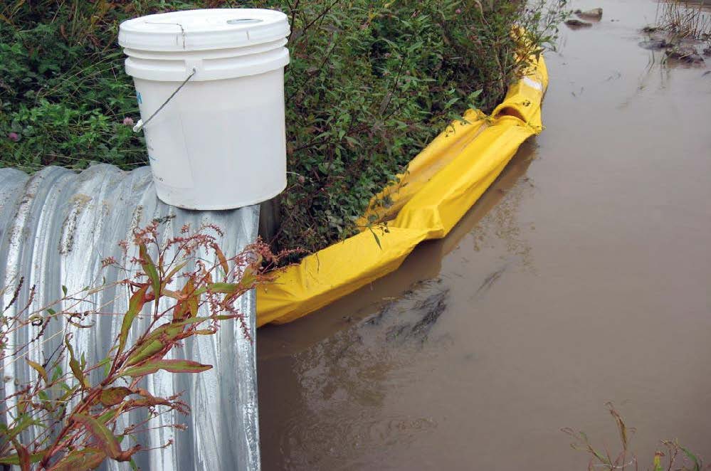
chemical and mounting it above the water (as shown here), although thorough mixing must be ensured. MnDOT hopes to develop a system that will automatically dispense a precise dose based on the amount of sediment in the water.
Since it is not feasible for workers to constantly monitor sediment concentration in stormwater runoff, MnDOT hopes to leverage the knowledge gained from this project to develop an automated system that measures the amount of sediment in runoff and automatically adds the appropriate dose of flocculant to treat the water.
“We’re trying to develop a portable water treatment plant that can be applied to construction projects to deliver clean runoff water after a storm,” said MnDOT Environmental Specialist Dwayne Stenlund.
Any chemicals recommended for field usage will need to be approved by the Minnesota Pollution Control Agency, and methods for disposing of used chemicals will need to be identified as the environmental impacts of residual chemicals are unknown.
*Editor’s note: This article was adapted from the September-October 2014 issue of our Accelerator newsletter. Read it online or sign up for your free subscription.
Related Resources
- Flocculation Treatment BMPs for Construction Water Discharges – Technical Summary, 1 MB (PDF); Final Report, 29 MB (PDF)