This article was originally published in Catalyst, February 2022.
Many Minnesotans have driven on I-35W through Minneapolis without giving any thought to how the freeway was built—or the impact it’s had on the community. Thanks to the work of several U of M researchers and Twin Cities residents, we now have the opportunity to learn just that.
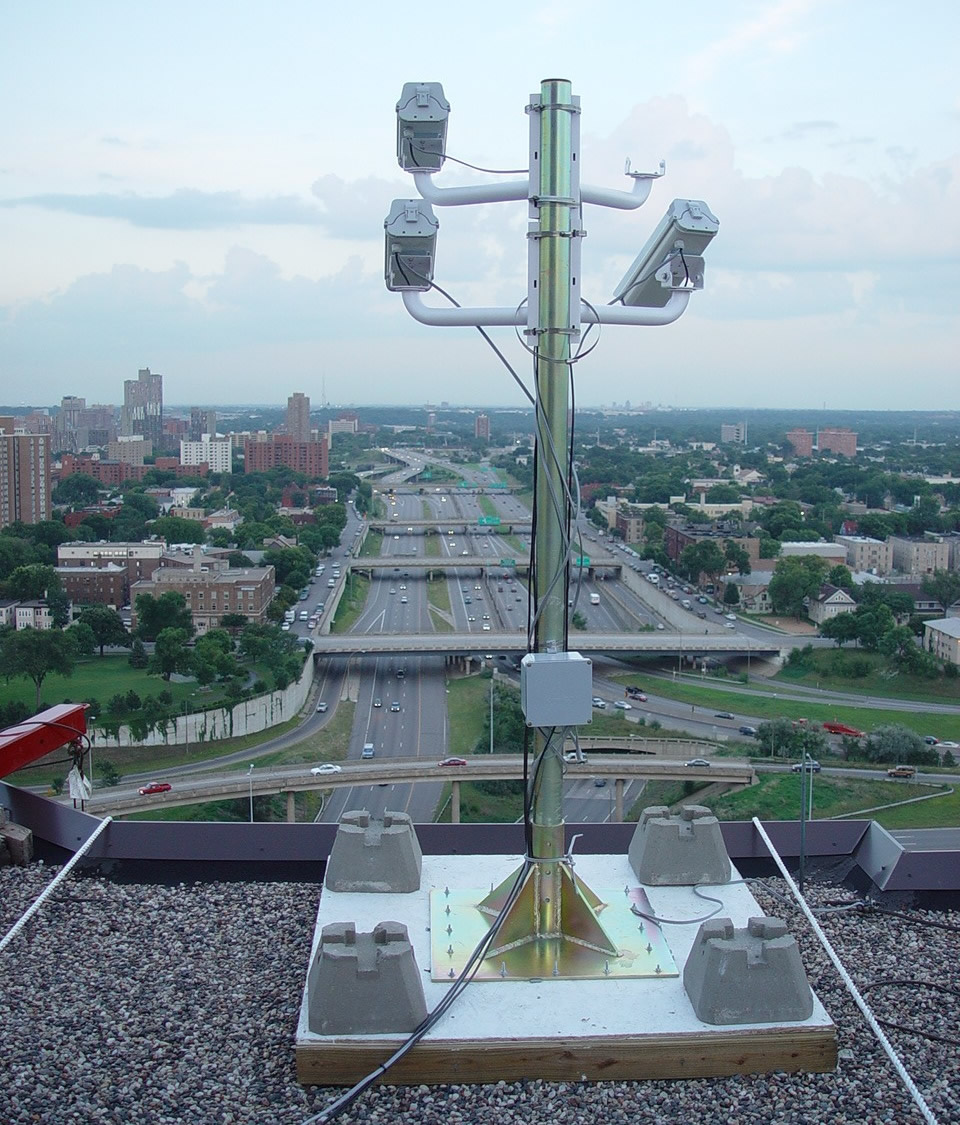
Two years ago, MnDOT installed a series of electronic speed limit advisory signs over Interstate 94 between Minneapolis and St. Paul. The Variable Speed Limit (VSL) system is designed to reduce congestion and help prevent crashes by recommending lower speed limits to motorists during periods of high traffic.
The new technology has worked in other places, including China and Germany. In Minnesota, a similar VSL system on I-35W reportedly had moderate benefits in reducing the total amount of congestion during the morning commute south of Minneapolis.
Although the verdict on I-94 congestion is still pending, a newly released study has found that the new system has not made a measurable impact so far on crashes in an accident-prone stretch of freeway in downtown Minneapolis. Why not?
University of Minnesota researcher John Hourdos has a few theories.
One is a simple time lag in the congestion reporting system. Another is a requirement that all lanes display the same speed limit, which he said causes confusion when only one lane is actually congested. The complexity of the I-94 commons also appears to be beyond what the VSL system was designed to do. And according to Hourdos, one of the most significant problems is the driving public simply doesn’t understand what the signs are telling them.
“People do not know what the system really does,” Hourdos said. “There hasn’t been much education on it other than a couple of news articles over the years. And when they try to decipher it on their own they get even more confused.”
The I-94 Commons area has a major bottleneck where the I-35W northbound ramp merges with I-94 westbound (between Cedar Avenue and 11th Avenue). Vertical red lines indicate locations of gantries that display variable speed limit advisories.
The advisory speed limits are posted in response to varying traffic conditions. As vehicles approach the commons area, the system measures speeds at the bottlenecks. If the traffic slows, the system transmits a reduced advisory speed to drivers approximately 1.5 miles upstream from the location of the slow-down.
Hourdos said many motorists mistakenly believe the speed displayed on the signs is either a reflection of the speed on the current stretch of highway or an indication of the speeds on the highway ahead, rather than a suggested speed for them to follow.
The requirement to display the same speed limit on all signs also compounds the problem, Hourdos said, because when drivers see that the slowdown is only occurring in certain lanes they tend to ignore the signs altogether.
“In the lane that is congested, the real speeds drop much faster than what the VSL system can respond to, reducing the functionality of the system to the eyes of the drivers,” Hourdos said, “while on the fast-moving lanes, it seems the system has no purpose at all.”
Data was primarily collected via cameras at the I-94 Commons’ Third Avenue Field station, overlooking an area with a particularly high crash rate.
So is the I-94 VSL system useless? Not necessarily. For one, the new study didn’t measure the system’s impact on congestion — only its ability to reduce crashes on a small portion of I-94. Moreover, the area in question, the I-94 Commons, is fairly unique, having two major bottlenecks, the highest crash rate in the state (nearly one every other day), and five hours of congestion during the afternoon rush hour alone.
“The VSL system was designed for implementation on any freeway and may not have been well-suited for the I-94 Commons area, which is a very complex corridor with high volume weaves and significant shockwave activity,” said MnDOT Freeway Operations Engineer Brian Kary.
Generally speaking, the VSL system was designed to identify slow traffic ahead of where free-flowing traffic is approaching slow or stopped traffic.
“The crash problems within the commons are caused by speed differentials between lanes and shockwave activity within the congestion,” Hourdos said. “The current VSL system was not developed to handle these types of conditions.”
MnDOT and the researchers aren’t giving up, either. A new project is starting later this year to develop and deploy a queue warning system specifically for this high-crash rate location.
A new research study is recommending ways to make it easier for developers and employers to select sites that encourage living-wage jobs and mixed-income housing near transit.
A key finding of the study, which was based on interviews with developers and business leaders, revealed a pent-up demand for transit access in the Twin Cities metropolitan region.
A team led by University of Minnesota researchers Yingling Fan and Andrew Guthrie found that providing a great work location is critical for employers in recruiting highly skilled young professionals who are likely to desire—or demand—urban living and access to transit.
They also found that multifamily residential developers, redevelopment specialists, and large corporate office tenants have a strong interest in transit-accessible sites, but regulatory barriers, cost issues, and uncertainty surrounding future development of transit often discourage both developers and businesses from selecting such sites.
In 2010, the City of Minneapolis installed 55 energy-efficient streetlights from nine different manufacturers along 46th Street between 34th and 46th avenues. The project, part of Hennepin County’s Minnehaha-Hiawatha Community Works program, was designed to field test various models of light-emitting diode (LED) and induction lights. Over the course of two years, researchers observed, evaluated and compared the performance of various lighting products, detailing the results in a recently published report available on the MnDOT Research Services website.
In a broad sense, the results of the study would appear to confirm what has become common knowledge regarding energy-efficient technologies: while they cost more up front, in the long run they have the potential to save money in the form of reduced energy and maintenance costs. The study also demonstrates that energy-efficient streetlights are capable of producing adequate light output and are well-received by residents.
However, if the big question is whether energy-efficient streetlights can save local governments money, the answer is somewhat complicated. The study found that both the levels of light ouput and the amount of time it takes to recoup costs varies significantly by product. Page 16 of the report (page 25 of the PDF) features a table comparing various products’ light output and estimated payback time. With one notable exception, the results show that products with the highest light output (i.e. the highest performers and therefore the most desirable) tend to also have the longest payback time. The amount of time it takes to generate a cost savings from energy-efficient streetlights can be as short as 2.6 years or as long as 24 years, depending on the product.
Some other interesting tidbits from the study:
Researchers observed operational cost savings of 50-75 percent, depending on the product.
Eighty percent of the savings came from reduced maintenance costs, while only 20 percent came from reduced energy costs.
In a survey of area residents, 76 percent responded positively to the new, energy-efficient lights.
The study demonstrated that energy-efficient streetlighting is a feasible option for local governments, with the caveat that agencies need to research lighting products thoroughly before making a choice as to which one to use. Ultimately, considering the ever-decreasing cost of LEDs, the use of energy-efficient streetlighting technologies is likely to grow.