When it comes to creating the transportation system of the future, MnDOT is already doing its research and laying the groundwork for great things to come.
James Benham, JB Knowledge, speaks at the Transportation Conference. (Photo by Rich Kemp)
Among the topics Benham cited in his talk were the Internet of Transportation, unmanned aerial vehicles (drones) and 3-D printing, which MnDOT is already studying or even using.
Internet of Transportation
MnDOT recently produced series of white papers on technological trends that could impact transportation infrastructure in Minnesota.
Google is one of many companies developing autonomous vehicle technology that researchers believe will make driving nearly extinct by 2040. (Photo courtesy of Google)
The report details how the transportation system can accommodate such imminent innovations as autonomous vehicles, mobile web services, mobility as a service, information and communication advances, infrastructure sensors and energy and fuel alternatives.
For example, researchers predict that driving faces near-extinction by 2040, when non-autonomous vehicles will no longer be allowed on public roads at most times. As a result, total transportation-related fatalities may drop 90 percent, road geometry, sightlines and other design priorities may shift, and capacity and speed limits will likely increase on most major roadways.
Unmanned Aerial Vehicles (Drones)
MnDOT is researching how data and images collected by drones could aid bridge inspectors.
When it comes to drones, MnDOT is already conducting important research that the rest of the nation is closely following. Tara Kalar and Jennifer Zink from MnDOT, and Barritt Lovelace of Collins Engineers, spoke about their efforts at last month’s conference.
Last year, MnDOT Research Services published a report titled “Unmanned Aerial Vehicle (UAV) Bridge Inspection Demonstration Project” that detailed how MnDOT could use drones to perform bridge inspection functions. The initial research project tested one drone’s capability in a variety of bridge inspection scenarios last summer at four Minnesota bridges.
In November, researchers conducted a second research phase to test a more specialized drone at the Blatnik Bridge in Duluth that coincided with that bridge’s regularly scheduled inspection.
A few weeks ago, researchers secured funding to conduct a research implementation project that aims “to implement a statewide UAS (unmanned aircraft systems) bridge inspection contract, which will identify overall cost effectiveness, improvements in quality and safety, and future funding sources for both state and local bridges,” according to the project proposal.
3-D Printing
Benham’s talk also addressed 3-D printing, which Chad Hanson, a District 6 project manager, has already used successfully.
Hanson spoke at the conference about his experience using 3-D printing to create a model of the Red Wing Bridge project that brought the project idea to life. According to Hanson, the model enhanced public engagement and informed preliminary design efforts for the bridge.
Chad Hanson, District 6 engineer, used 3-D-printing to create a model of the Red Wing Bridge that was used during the project’s public engagement events. (Photo by Mike Dougherty)
Partners, stakeholders and members of the public could see, touch and hold the 3-D printed models, which accentuated the project’s engagement process.
To mark Earth Day 2016, MnDOT Research Services is taking a glance at five stellar examples of current research projects at MnDOT that involve pollution control, wetland mitigation, road salt reduction and new ways of recycling pavement.
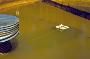
Temporary stormwater ponds with floating head skimmers can remove clean water from the surface of a settling pond.
Soil carried away in stormwater runoff from road construction sites can pollute lakes and rivers.
Stormwater settling ponds provide a place for this sediment to settle before the water is discharged into local bodies of water. However, since stormwater ponds have limited space, a mechanism is needed to remove clean water from the pond to prevent the overflow of sediment-laden water.
MnDOT-funded researchers designed temporary stormwater ponds with floating head skimmers that can remove clean water from the surface of the settling pond, using gravity to discharge water into a ditch or receiving body.
The study, which was completed in spring 2014, identified five methods for “skimming” stormwater ponds that can improve a pond’s effectiveness by 10 percent. MnDOT researchers also created designs for temporary stormwater ponds on construction sites with the capacity to remove approximately 80 percent of suspended solids.
These designs will help contractors meet federal requirements for stormwater pond dewatering. Researchers also determined how often a pond’s deadpool must be cleaned, based on watershed size and pool dimensions.
Stormwater infiltration rates at five swales were significantly better than expected based on published rates.
Stormwater can pick up chemicals and sediments that pollute rivers and streams. Roadside drainage ditches, also known as swales, lessen this effect by absorbing water. But until recently, MnDOT didn’t know how to quantify this effect and incorporate it into pollution control mitigation measures.
In a study completed in fall 2014, researchers evaluated five Minnesota swales, measuring how well water flows through soil at up to 20 locations within each swale.
A key finding: grassed swales are significantly better at absorbing water than expected, which may reduce the need for other, more expensive stormwater management practices, such as ponds or infiltration basins.
This could save MnDOT and counties significant right-of-way and construction costs currently expended on more expensive stormwater management techniques.
Even with little or no road salt, a permeable pavement like this porous asphalt in Robbinsdale, Minnesota, collects little slush and snow in the winter because it warms well and remains porous enough to infiltrate surface water effectively.
Road salt is used for de-icing roadways during winter months, but can have a negative impact on the environment.
This research, which was just approved for funding through the Minnesota Local Road Research Board in December 2015, will investigate the reduction in road salt application during winter months that can be attained with permeable pavements, while still providing for acceptable road safety.
Some initial investigations (see previous study) suggest that road salt application can be substantially reduced, even eliminated, with permeable pavement systems. The proposed research will investigate this hypothesis more thoroughly, and further document the reduction in road salt application that can be expected with permeable pavement.
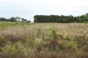
This photo from spring 2015 shows that wetlands have begun to take hold along Highway 53.
Road construction in northeast Minnesota often causes wetland impacts that require expensive mitigation. However, borrow areas excavated for road construction material can be developed into wetland mitigation sites if hydric vegetation, hydric soils and adequate hydrology are provided. Fourteen wetland mitigation sites were constructed north of Virginia, Minnesota along the U.S. Trunk Highway 53 reconstruction project corridor and evaluated for wetland. The sites were established with the goal of mitigating for project impacts to seasonally flooded basin, fresh meadow, shallow marsh, shrub swamp, wooded swamp, and bog wetlands. All but one of the sites consistently meet wetland hydrology criteria.
The sites contain a variety of plant communities dominated by wet meadow, sedge meadow, and shallow marsh. Floristic Quality Assessment (FQA) condition categories for the sites range from “Poor” to “Exceptional.”
According to the research report published in March 2016, these sites have shown the potential for creating mitigation wetlands in abandoned borrow pits in conjunction with highway construction. Adaptive management, particularly water level regulation, early invasive species control, tree planting, and continued long-term annual monitoring can make mitigation sites like these successful options for wetland mitigation credit.
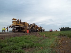
This photo shows a cold in-place recycling equipment train in action.
MnDOT already extends the lives of some old concrete highways by paving over them with asphalt instead of tearing them up. Now MnDOT hopes to add a third life for these old concrete roads by using a process called cold in-place recycling to re-use that existing asphalt pavement when it reaches the end of its life.
Cold in-place recycling (CIR) uses existing pavements, without heat, to create a new layer of pavement. It involves the same process of cold- central plant mix recycling (which is being employed by MnDOT for the first time on two shoulder repair projects this year), but it is done on the road itself by a train of equipment. It literally recycles an old road while making a new road.
CIR has been in use in Minnesota for 20 years, but only with hot-mix asphalt (HMA) over gravel roads. The purpose of a new study, which was approved for funding in April 2016, is to validate Iowa’s promising new practice using CIR on bituminous over concrete.
In this research project (see proposal), MnDOT will use cold-in-place recycling to replace the asphalt pavement on a concrete road and then evaluate it for several years, comparing it also with control sections.
Along with the potential of a better service life, the cost of CIR is much lower than new hot mix asphalt (HMA). Therefore, a 20-percent to 30-percent price reduction per project may be realized.
Darryl Oeltjenbruns, snowplow driver in District 7, operates the only driver assist system, or DAS, equipped snowplow in the state. The system helps snowplow operators see road alignments and features such as turn lanes, guardrails and road markings. (Photo by Chase Fester)
By Sue Roe, MnDOT Communications
Southwest Minnesota has the highest average wind speeds in the state—bad news for MnDOT snowplow operators who often drive in low visibility to clear roads.
“We have more days when the wind blows than when it doesn’t,” said Chase Fester, MnDOT District 7 transportation operations supervisor. “We struggle with the wind.”
That’s why District 7 is piloting a snowplow driver-assist system (DAS) developed by University of Minnesota researchers to combat the blowing snow and fog that often cause zero visibility. The DAS helps snowplow operators see the road alignment and features, such as turn lanes, guardrails, and road markings. Even in less extreme winter weather, snowplow operators gain assurance of their lane location using the system.
The driver assist system displays a white box on the screen when an obstacle, or in this case a mailbox, is located. If the object appears in the lane, such as a car stuck in a snow drift, the box turns red and gets bigger as the snowplow gets closer to the object. (Photo courtesy of MnDOT District 7)
The DAS was developed and refined over the past 20 years under multiple research projects funded by MnDOT and the USDOT’s University Transportation Center program. Professor Max Donath, director of the University of Minnesota’s Roadway Safety Institute, led the work. In addition to plows, the DAS technology has also been applied in other specialty vehicles such as patrol cars and ambulances. Numerous vehicles using the system have been deployed in both Minnesota and Alaska.
The DAS uses GPS technology and a front-mounted radar to provide an image of the road and any obstacles in front of the operator. The image is displayed on a monitor inside the cab of the plow. The system also vibrates the operator’s seat as a warning if the plow veers too close to the roadway’s centerline or fog line.
“If the driver gets within one foot of the fog line on the right side, the right side of the seat vibrates. If the driver gets too close to the centerline on the left side, the left side vibrates,” said Fester.
The vibrations continue until the driver moves back into the center of the lane. The driver can also turn off the warning feature to clear snow from the shoulder.
The DAS is currently installed in one truck in District 7. The $75,000 cost makes it difficult to install in every truck in the district or the state, although having at least one system in every district may be possible, Fester said.
Fester said the system proved its worth one day in February when blizzard conditions caused zero visibility and forced many road closures in southwest Minnesota. He was called out at 2 a.m. Feb. 8 to assist a stranded state trooper and several motorists on a 12-mile stretch of Hwy 60 between Windom and Heron Lake. Fester drove a pickup behind the DAS-equipped snowplow, driven by Darryl Oeltjenbruns, to reach them.
As the DAS identified stranded vehicles on the way to Heron Lake, Fester and Oeltjenbruns checked to make sure they weren’t occupied with people. Once they made it to Heron Lake, they stopped at the community center, where the state trooper and the stranded motorists he brought in were located.
On the way back to Windom, Fester and the state patrolman continued to check on stranded vehicles as the DAS-equipped snowplow led the way. If the vehicles weren’t in the ditch, motorists drove behind the two MnDOT vehicles. If their vehicles were in the ditch, motorists rode in a Suburban that was also being escorted to Windom. After returning to Windom, the motorists were dropped off at motels or truck stops.
“When we first went out, there were about six stranded vehicles. Coming back from Heron Lake, there were about 15,” Fester said. “At one time, we had 12 vehicles in line as we drove back to Windom, driving about 10 to 15 miles per hour.”
Later that morning the DAS system was used again to locate other motorists.
“We continued to use it until about 10 a.m. or 11 a.m. that day,” Fester said. “The system worked great and kept everyone safe. It was an interesting morning.”
(Reprinted and adapted with permission from an article by Sue Roe in MnDOT’s Feb. 17, 2016 Newsline.)
The benefits of living snow fences and other snow control tools to keep roadways clear of blowing and drifting snow have been known for decades, and MnDOT has been using a variety of these techniques for years to catch snow before it gets to a road.
Living snow fences often consist of trees, grasses and even corn stalks left standing in a farmer’s field. Now willow shrubs are being added to the list as a fast-growing, inexpensive snow control measure.
What’s new
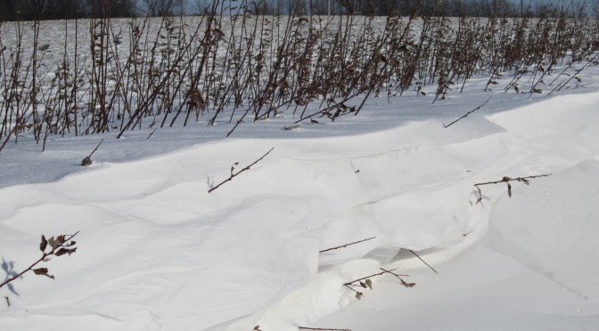
Fish Creek willow shrubs (left) grow alongside corn in September 2015.
Researchers recently completed a study that investigated whether willow shrubs could make good living snow fences. While typical snow-fence plants, such as dogwood or cranberry shrubs, can take five to 20 years to establish themselves, shrub willows were effective at trapping snow after just two growing seasons, according to the study.
In spring 2013, researchers installed three varieties of shrub willow side-by-side in two-row and four-row configurations along about a quarter of a mile of Highway 14 in Waseca, where snow drifts are an issue. In April 2014, they cut the shrubs down to the ground to encourage branching and bush density. Though the trimmed willows had little impact on drifting snow the first winter, each willow-shrub plot was collecting two to three metric tons of snow by the second winter, according to the research report. Researchers believe that after three or four growing seasons the willow shrubs could catch the entire mean annual snowfall on the site.
In the four-row configuration recommended by researchers, costs of raising, furnishing, planting and mulching came to about $3.60 per plant, which is dramatically less than the contract bid cost for traditional living snow fence species that cost more than $50 per plant. In addition, the willow shrubs could be harvested and sold as biomass every few years to provide an income source.
Past research
Willow trees is just the latest advancement in the state’s snow control program. A 2012 research project evaluated the costs and benefits of living snow fences and provided MnDOT with a payment calculator to determine how much to compensate landowners for installation and maintenance costs.
MnDOT has used these tools and other promotional efforts to nearly double the number of farmers with contracts for corn rows enrolled in the Living Snow Fences program.
What’s next
The willow species recommended by researchers will be evaluated further in 2017 when they install it as a living snow fence on a new construction site on Highway 60 between Windom and Mountain Lake. Researchers also recommend a future study to compare volume of road salt use before and after installation. They also want to look into identifying appropriate buffer distances to keep willow roots from interfering with cropland root systems.
Roadways for humans can sometimes create roadblocks for fish, but researchers hope to establish a set of culvert design practices to help aquatic creatures get where they’re going.
Many fish depend on mobility along a river for feeding and spawning. Where roads meet rivers, however, culverts can block fish and other aquatic organisms that can’t navigate changes in current, lighting and other factors.
Waterway barriers threaten an already endangered species of minnow known as the Topeka shiner (pictured above). It can also be a big problem for economically important fish such as trout or northern pike. That’s why the Minnesota Department of Natural Resources prefers building bridges to culverts.
However, bridges are not always economically feasible, and so MnDOT is working closely with the DNR to develop culverts that protect both public safety and the environment.
Culverts allow water to pass under roads. Occasionally, they can harm a stream’s fish habitat by inadvertently acting as a barrier to fish passage or migration. There are nearly 11,000 culverts in Minnesota.
Sediment Content
Recent research suggests that installing boxed culverts differently could greatly improve fish passage.
Culverts are typically placed a little below the streambed with the expectation that the stream flow will naturally fill them with sediment. Researchers tested that assumption and found it to not always be accurate.
“We found that pre-filling the culvert with sediment that replicates the streambed as part of the installation process helped prevent upstream erosion and the development of vertical drops that can become barriers to aquatic movement,” said Jessica Kozarek, a University of Minnesota research associate. “In addition, pre-filling the culvert helped ensure the sediment remained inside the culvert flows were high and water moved quickly during rainstorms.”
MnDOT has been working with the DNR to identify the conditions that determine whether a newly installed culvert will naturally fill with sediment, replicating surrounding streambed conditions, or whether a stream’s water flow will transport sediment out of a culvert.
Using an experimental flume at the University of Minnesota’s St. Anthony Falls Laboratory, researchers tested MnDOT’s standard box culvert design under a variety of stream conditions.
Laboratory simulations suggest that filling a culvert with sediment at installation, rather than allowing it to fill over time is, with some exceptions, generally the best approach for low- and moderate-grade streams. Additionally, steep, fast-moving waters require a filled culvert with structures such as larger rocks to keep sediment in place. These structures also create steps, pools and riffles that enable fish to rest as they move upstream.
MnDOT will use this latest research, along with conclusions from other recent studies, to create a guide for fish-friendly culvert designs.
“Of all the things we’ve studied, there are maybe three or four research projects. This manual will pull it all together,” said Petra DeWall, state waterway engineer at the Minnesota Department of Transportation.
Further research is underway to determine whether aquatic organisms are deterred by low light conditions in long, dark culverts. Researchers are also looking into whether mussel spat rope could be used to create a rough bottom to reduce water speed in culverts with no sediment.
Bridges over Minnesota waterways need to be protected from currents by a field of interlocking angular rocks called riprap. Without these rocks along the abutment, moving water could wear away the soil that supports a bridge’s foundation. The faster the water, the larger the riprap must be to provide adequate protection.
While some parts of Minnesota have quarries rich with angular rock, other parts don’t – particularly the northwest and western regions. Bridge projects in those areas sometimes resort to the expensive practice of trucking in stones. Other times field stones are used, but they are less effective and must be replaced more often.
There soon could be a better option thanks to research coordinated by the Minnesota Department of Transportation and funded by the Minnesota Local Road Research Board.
At a few test sites around the state, researchers have used a grout mixture to cement smaller, rounded rocks together at a bridge abutment. Once applied to the rocks, the mixture forms what is called “matrix riprap.” The concept is in use in Europe for many bridge piers, but MnDOT was more interested in learning how it could be used on bridge abutments.
Matrix riprap is currently in use in Minnesota at the following bridges:
Highway 23 over the Rum River in Milaca
Highway 8 over Lake Lindstrom channel in Lindstrom
Prairie Road over Coon Creek in Andover
A MnDOT crew applies grout to rounded rocks at a bridge abutment in Milaca in May 2012. The grout cements the rocks together to form matrix riprap, which has shown to be significantly stronger than conventional riprap.
In May 2012, matrix riprap was placed at the Milaca bridge, which sits alongside a high school. Researchers hoped the use of matrix riprap would prevent vandals from removing the riprap rock and throwing it into the river. According to Nicki Bartelt, a MnDOT assistant waterway engineer, the matrix riprap has proven to be extremely strong and effective.
“Not only is matrix riprap significantly stronger than regular riprap, but it helps prevent vandalism as well,” Bartelt said. “The Milaca installation has been in place for three years now. It looks pretty good and it’s weathering well.”
In the lab, matrix riprap held up extremely well on mechanical pull tests and hydraulic flume tests. In fact, researchers were unable to determine the matrix riprap fail point on many tests, even after applying 10 times the shear stress that regular riprap can withstand. Matrix riprap was tested with both angular and round rock with no change in performance.
A new matrix riprap installation recently went in on the Highway 95 bridge over the Rum River in Cambridge. Later this summer, plans call for an installation on the Highway 60 bridge over the north fork of the Zumbro River in Mazeppa.
“The Highway 60 bridge is being replaced, and the river there has extremely high velocities, so we’re using the matrix riprap instead of regular riprap just because of the size of rocks that would be needed,” Bartelt said.
At least two more installations are planned for 2016. In the future, researchers plan to determine the fail point for matrix riprap. They also hope to study potential environmental effects the grout may have underwater.
MnDOT has also worked with local governments that have tried matrix riprap for themselves. One municipality is trying it as a heavy duty erosion control measure. The concept is catching on outside Minnesota as well.
“We have gotten a lot of inquiries from other states, and we have lent out the spec a lot,” Bartelt said. “Iowa, New Hampshire, Maine, Indiana, Wisconsin and Illinois are among the states to express interest. We have talked to a lot of people about it, so they tend to use our research.”
Motorists are experiencing less delay on metro-area highways, thanks to major changes to the Twin Cities’ ramp metering system.
The Minnesota Department of Transportation has reconfigured ramp meters to be more in sync with real conditions. With changes to the turn-on and turn-off criteria, the meters are actually running for a shorter period of time and are only activated when needed.
Ramp meters are traffic lights placed on freeway entrance ramps that control the frequency that vehicles can enter the highway. Sensors embedded in the pavement collect the vehicle traffic data used to time approximately 440 ramp meters.
Staff at the Regional Transportation Management Center, which manages the ramp meters, say the whole system is operating better because of changes that were implemented approximately one year ago (based off a 2012 study).
University of Minnesota-Duluth professor Eil Kwon developed the system’s new software algorithms. In a case study of Highway 100, he found that the delay on the mainline dropped by nearly half.
On northbound Highway 100, the amount of “delayed vehicle hours” — defined as the vehicle hours of traffic flow with speeds less than 45 mph — that motorists experienced dropped 48 percent during the months of October and November in 2012 when compared to the same period in 2011. During the same time period, total volume on that section of northbound Highway 100 increased by 2.7 percent, Kwon said. In spring 2013, the amount of delayed vehicle hours had been reduced by 17 percent.
These results are preliminary, as additional analysis is needed to determine if these results are typical throughout the system on other freeway corridors. However, based on a personal savings of $16.50 per hour, the scenario described above represents a cost savings to motorists of $1,353 to $3,447 per day (depending on the season). That’s as much as $339,150 to $861,640 per year for just a six-mile stretch of highway.
More efficient
Under the old system, each ramp meter would turn on based on current traffic conditions, but the criteria to turn on were easily met, causing the meters to turn on too soon. The old system did not have turn-off criteria, allowing meters to run until a pre-set time of day.
With the new system, improvements were made to make the meters respond more appropriately to current traffic conditions. The turn-on criteria were improved so that meters come on only when needed, and turn-off criteria were added, allowing meters to turn off when traffic conditions improved.
The new metering system is particularly effective at reducing the number of meters operating on light traffic days.
“On days like the ones leading up to Thanksgiving, where traffic may be 10-to-15 percent less than normal, instead of, say, 150 ramp meters being on at a particular time, now maybe only 50 ramp meters will be operating,” explained MnDOT Freeway System Operations Engineer Jesse Larson.
Upgrades to the ramp metering system also allow for a better picture of what traffic is like at a given moment, because it’s now based on corridor density rather than traffic flow.
Traffic flow is the measurement of the number of vehicles passing a given point. Using traffic flow was flawed, in that similar traffic flows can occur at different speeds. The old system couldn’t differentiate between 1,000 cars passing by at 20 miles per hour versus 1,000 cars passing at 60 miles per hour, for example.
Corridor density, on the other hand, is the number of vehicles per lane per mile. By measuring density instead of traffic flow, the system has a more accurate picture of what current conditions are like on the freeway.
Another bonus: ramp meters will no longer release a bunch of cars simultaneously once an entrance ramp fills up. That’s because the system can now detect the ramp filling up and release the extra cars gradually instead.
Twin Cities ramp meters now turn on and off based on live traffic conditions.
MnDOT is testing a mobile road condition monitor that uses infrared technology to detect hazardous ice, snow or wet conditions without even touching the pavement.
Maintenance crews hope the device, called the High Sierra Surface Sentinel, could help them better determine when it’s time to apply salt when they’re plowing. The mobile sensor reports air temperature, surface temperature and road friction data.
“The biggest reason we’re looking at this is for the friction reading,” said MnDOT Salt Solutions Coordinator Joe Huneke. “Typically, when operators are patrolling their route and the road looks like it’s getting icy, they’ll err on the side of caution and apply salt — and it may not need it.”
The device being tested by snow and ice crews in northern Minnesota would also provide real-time surface weather conditions. Currently, plow operators and supervisors must enter road conditions into a computer or relay them by phone, a time-consuming process that operators are not always able to perform in a timely manner.
The biggest potential benefit, however, is lower salt consumption.
“Sometimes you get a light cold snow event where it might look like there’s a little ice on the road, but, in fact, you have good friction numbers and you don’t need salt. Once you put chemical down, you’re committed to it,” Huneke said.
District 1 snow and ice crews are evaluating the unit pictured below for its accuracy and effectiveness in determining slippery conditions. It will be compared with another device tested in District 3 that also uses infrared technology to determine how slippery the road is, and technology being tested in District 6 that uses gravitational force to determine the road surface friction.
MnDOT it testing this mobile road condition sensor, which provides real-time surface weather condition of roadways.
Related Research
MnDOT’s Office of Maintenance has its own research program designed to let maintenance personnel test innovative ideas to keep our roads smooth, snow-free and safe. They even put out a monthly bulletin featuring new ideas and technologies. (You can find the back issues here.)
The Minnesota Department of Transportation is testing a crowdsourcing application that will allow motorists to update winter weather road conditions on the state’s 511 system.
The Regional Transportation Management Center is planning a soft launch of Citizen Reporting in April, initially inviting MnDOT employees to post their experiences on routes they travel. By next winter, the RTMC hopes to invite the public to do the same.
“We suspect that citizen reporters will be similar in ethic to the kinds of people who volunteer to be weather spotters,” said MnDOT Transportation Program Specialist Mary Meinert, who assists with day-to-day operations of 511.
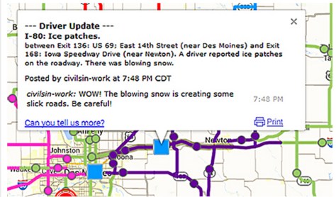
Iowa launched Citizen Reporting in November. Here is an example of a citizen report.
Currently, MnDOT maintenance crews report road conditions, but Greater Minnesota lacks 24/7 coverage and its reports can become quickly outdated, especially on highways that aren’t plowed as frequently or lack traffic cameras, said 511 System Coordinator Kelly Kennedy Braunig.
Citizen reporting, especially on weekends, will help keep that information fresh.
“We try to explain on the website that we only update from 3–6 a.m., 3–6 p.m. Monday through Friday and as road conditions change, but we still get many emails requesting more frequent road condition information,” Braunig said.
Even a recent comment on MnDOT’s Facebook page pointed out the limitations in one area of the state: “Updates [only] come during government work hours.”
Growing Service
It’s actually a welcome sign that the public wants more from 511.
Seven years ago, when Braunig applied for her job, not many people used 511. In fact, at the time, she wasn’t even aware of the service, which provides information to travelers on weather-related road conditions, construction and congestion.
Today, 511’s online program and mobile app are accessed by more than 5,000 people per day during the winter (and about half as many during the summer). Data comes from MnDOT’s construction and maintenance offices, as well as state trooper data and incident response. This real-time information is available for all of Minnesota.
In the Twin Cities metro area, more than 700 traffic cameras allow MnDOT and State Patrol dispatchers to check the condition of 170 miles of highways and monitor traffic incidents at any time. Rochester, Duluth, Mankato and Owatonna also have cameras for incident management and traffic monitoring.
The 511 system’s greatest challenge is in Greater Minnesota, where road condition information is used daily by schools, ambulance personnel and truckers, as well as the traveling public, but information isn’t updated frequently outside of business hours. Citizen reporting will be a beneficial resource.
Other states
Other northern states face similar challenges as Minnesota, but have been able to improve the timeliness of road condition data with assistance from truckers and other motorists.
In Wyoming, more than 400 citizen reporters (primarily truckers) call in road conditions to the Transportation Management Center. In Idaho, citizen reporters directly put the information into the 511 system. Minnesota will be the fifth state to adopt citizen reporting, following Iowa, which launched its service in November 2014.
Like Iowa, Minnesota’s citizen reporting will initially focus on winter roads.
To participate, people will need to take an online training module and then register their common routes, perhaps the highways they take to work or their way to the cabin on the weekends. These contributions will be marked as a citizen report on the website.
“Minnesota truck drivers are loyal users of the 511 system and we suspect they will also make some of our best reporters,” Meinert said.
Minnesota is part of a 13-state consortium that shares a 511 service technology provider. States with citizen reporting recently shared their experiences in a Peer Exchange sponsored by North/West Passage, a transportation pooled fund that is developing ways to share 511 data across state lines.
“With citizen reporting we hope to give people a voice and a chance to participate,” Braunig said.
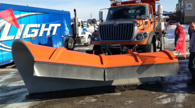
If the plow pictured above looks like two different plows welded together, it’s because they are.
Minnesota Department of Transportation snow plow operators in southwestern Minnesota have invented an experimental plow that uses the wind to cast snow from the road without impeding traffic or the operator’s view.
Manufactured for MnDOT by Fall Plows, the plow incorporates half of a traditional bull-dozer style plow with half of a Batwing-style plow. It eliminates the large “ear” on the driver’s side of a Batwing style plow that can stick out into oncoming traffic during center-line snow removal.
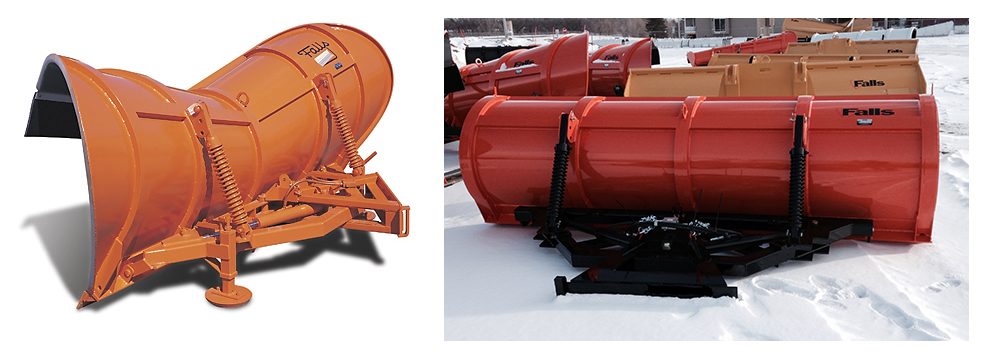
Half of the reversible batwing-style plow, pictured at left, was combined with half of the reversible bulldozer-style plow, at right.
District 8 Willmar Maintenance Supervisor Dennis Marty said he was looking for a reversible-style plow that could be used in the heavy winds and reduced visibility from blowing snow that are prevalent in western Minnesota.
When drivers are plowing against a northwest wind in rural Minnesota, the snow coming out of the chute will sweep across the truck and blind drivers, so operators needed a plow with a reversible system so they could throw the snow with the wind.
While an express plow with chutes on both ends (batwing-style), pictured above at left, was great for throwing snow to the right, when snow plow drivers took it down narrow two-lane roads, the plow stuck 2.5 feet into the oncoming lane and its big barrel partially blocked the headlights and the operator’s view.
So operators tried a regular one-way plow (pictured below), which resembles a funnel laid on it side, and put it on a reversible system that would allow operators to turn the plow both directions, so it could throw snow to the right or the left. However, this plow couldn’t blow snow high enough to the left, so snow piled in the left traffic lane.
One-way reversible plow.
Marty said he spent four to five years looking for a plow that combined the batwing and bull-dozer designs, but he couldn’t find anything sturdy and maintenance-free enough. Finally, he and Maintenance Research Program Administrator Ryan Otte sat down with Falls Plows in Little Falls, Minnesota and asked the company to build one.
The plow will be useful on low-volume roads that have little traffic during the middle of the night, which allows plow operators to cast the snow with the wind.
The Willmar office began using the experimental plow last winter and will be replacing all of its plows with it. Snow plow drivers from other areas of the state have been so impressed that at least two other maintenance districts have also ordered them.
Related Research
MnDOT’s Office of Maintenance has its own research program designed to let maintenance personnel test innovative ideas to keep our roads smooth, snow-free and safe. They even put out a monthly bulletin featuring new ideas and technologies. (You can find the back issues here.)