When drivers approach a roadway work zone at high speeds, they put the lives of work-zone flaggers at risk. To keep flaggers safe on the job, U of M researchers are looking for better ways to capture drivers’ attention—and compel them to slow down—as they approach flagger-controlled work zones.
Kathleen Harder, director of the Center for Design in Health, and John Hourdos, director of the Minnesota Traffic Observatory, identified and tested new work-zone warning elements to more effectively capture and sustain driver attention. The project was funded by MnDOT and the Minnesota Local Road Research Board.
The project began with a simulator study in which participants completed three drives, each featuring a work zone with different warning treatments. One condition was a traditional four-sign configuration currently used to warn drivers approaching work zones. The other two conditions featured a variety of new elements, including signage with new messaging such as a “one-lane road ahead” sign with flashing LED lights, a dynamic speed warning sign equipped with a loud warning horn that sounded if drivers exceeded the speed limit, and portable rumble strips.
“Overall, we found that the new set of elements is more effective than the elements currently used to reduce driving speeds on the approach to a flagger-controlled work zone,” Harder says.
Although adding LED lights to the one-lane road sign had no significant effect on drivers’ speeds, findings indicated that the dynamic speed sign coupled with the horn was more effective than the dynamic sign alone.
To test these new elements under real-world conditions, the researchers conducted field tests evaluating two configurations in Minnesota work zones. The first configuration followed the minimum standards outlined in the Minnesota Manual on Uniform Traffic Control Devices. The second deployed signs employing new messaging and attention-getting devices, including a dynamic speed warning sign, horn, and rumble strips.
Findings showed that the combination of the dynamic speed warning sign and the horn successfully reduced the overall speed of vehicles approaching the work zone. The portable rumble strips did not cause any significant speed reduction, but this may have been related to their location downstream from the dynamic speed sign and horn.
“Our findings reveal that the new set of elements designed to capture driver attention—including new messaging, a dynamic speed trailer, and horn—had a significant influence on reducing driver speed,” Harder says. “The experimental layout practically eliminated high-speed outliers and successfully reduced the approach speed to the flag operator.”
Imagine that you’re driving to work as usual when your smartphone announces, “Caution, you are approaching an active work zone.” You slow down and soon spot orange barrels and highway workers on the road shoulder. Thanks to a new app being developed by University of Minnesota researchers, this scenario is on its way to becoming reality.
“Drivers often rely on signs along the roadway to be cautious and slow down as they approach a work zone. However, most work-zone crashes are caused by drivers not paying attention,” says Chen-Fu Liao, senior systems engineer at the U’s Minnesota Traffic Observatory. “That’s why we are working to design and test an in-vehicle work-zone alert system that announces additional messages through the driver’s smartphone or the vehicle’s infotainment system.”
As part of the project, sponsored by MnDOT, Liao and his team investigated the use of inexpensive Bluetooth low-energy (BLE) tags to provide in-vehicle warning messages. The BLE tags were programmed to trigger spoken messages in smartphones within range of the tags, which were placed on construction barrels or lampposts ahead of a work zone.
The researchers also developed two applications for the project. First, they designed a smartphone app to trigger the audio-visual messages in vehicle-mounted smartphones entering the range of the BLE work-zone tags. A second app allows work-zone contractors to update messages associated with the BLE tags remotely, in real time, to provide information on current conditions such as workers on site, changes in traffic, or hazards in the environment.
Field tests proved the system works. “We found that while traveling at 70 miles per hour, our app is able to successfully detect a long-range BLE tag placed more than 400 feet away on a traffic barrel on the roadway shoulder,” Liao says. “We also confirmed the system works under a variety of conditions, including heavy traffic and inclement weather.”
“This was a proof of concept that showed that smartphones can receive Bluetooth signals at highway speeds and deliver messages to drivers,” says Ken Johnson, work-zone, pavement marking, and traffic devices engineer at MnDOT. “Future research will look into how we should implement and maintain a driver alert system.”
This future work includes using the results of a human factors study currently under way at the U’s HumanFIRST Laboratory to create recommendations for the in-vehicle message phrasing and structure. Then, researchers plan to conduct a pilot implementation with multiple participants to further evaluate the system’s effectiveness.
According to MnDOT, another phase of the project may investigate how to effectively maintain the BLE tag database. This phase could also investigate implementation options, such as how MnDOT can encourage drivers to download and use the app.
Could the same infrared technology that’s used by security firms to detect trespassers be used to spot carpool lane violators? Not yet, says new research sponsored by MnDOT, which shows that to consistently detect passengers through windshield glass, the system would require a laser that might harm people’s eyes.
“Some vendors have proposed significant investments in sensing technology for HOV/HOT lane enforcement,” said Nikos Papanikolopoulos, Professor, University of Minnesota Department of Computer Science and Engineering. “This research demonstrated that it’s not safe, so the tests saved a lot of money and protected the well-being of drivers.”
“Development is still continuing in the industry, so we will cautiously evaluate sensing technologies as they come along,” said Brian Kary, MnDOT Freeway Operations Engineer. “This research gave us a solid base of knowledge about what we’ll be looking for and what we need to avoid.”
Papanikolopoulos served as the research project’s principal investigator, and Kary served as technical liaison.
What Was the Need?
High-occupancy vehicle/high-occupancy toll (HOV/HOT) lanes have gained popularity in recent years as a way to address highway congestion in urban areas. However, enforcing the provisions that either prohibit or charge a toll to single-occupant vehicles in HOV/HOT lanes can be challenging. Currently, enforcement is handled by law enforcement officers, but this is a labor-intensive process that can’t catch every violator and can create a traffic safety hazard.
Obtaining technology to assist officers with enforcement is a goal for MnDOT and many other agencies that operate HOV/HOT lanes, and several manufacturers are working to develop enforcement cameras. But this has proven to be a difficult task. Window tinting and glare from sun-light can thwart common sensing technologies like video cameras and microwave radar (commonly used in speed limit enforcement). Previous research using near-infrared sensors has shown promise, but none has produced completely successful results.
This study tested Honeywell’s Tri-Band Infrared (TBI) sensor, which was originally used to automatically detect intrusions at high-security entrance gates. In addition to a black-and-white camera and an illuminator, the TBI has two co-registered near-infrared cameras. The system takes advantage of the fact that human skin reflects infrared light much more effectively at wavelengths below 1400 nanometers. The TBI’s infrared cameras are sensitive to different wavelengths, one below and one above that threshold, and fusing the images from these two cameras makes silhouettes of faces more prominent.
What Was Our Goal?
The goal of this project was to evaluate whether the TBI sensor is suitable for HOV/HOT lane enforcement applications.
Infrared lasers helped the TBI sensor detect people through glass, but they also pose a danger to eye safety.
What Did We Do?
Investigators first tested the sensor outdoors on oncoming vehicles with known positions that ranged from 25 to 140 feet from the sensor. These tests demonstrated that the sensor had limited ability to penetrate modern vehicle glass, possibly because the system’s illuminator component was ineffective.
Investigators purchased two infrared lasers providing illumination at wavelengths of 1064 nanometers and 1550 nanometers to increase the TBI sensor’s ability to detect people through windshield glass. Then they conducted indoor tests to compare the impact of these illuminators with that of the original illuminator: With a test subject holding front passenger windows from several manufacturers in front of his face, the lasers were aimed at the subject while the TBI attempted to detect him.
Finally, investigators conducted outdoor tests using the TBI to detect people in three test vehicles from the front and the side under both sunny and cloudy conditions. These tests were conducted both without illumination and with the aid of high-power incandescent spotlights modified to output infrared light, and with the sensor at several different distances from the vehicles.
What Did We Learn?
The indoor tests demonstrated that when aided by supplementary illuminating lasers, the TBI sensor was capable of detecting humans through commonly manufactured vehicle window glass.
However, to achieve successful results, these lasers must operate with high power in a narrow range of wavelengths. Despite operating outside the visible spectrum, they can damage human eyes when operating at the necessary power level to enable effective detection through glass. While investigators conducted this project’s indoor tests with adequate protection, there is currently no way to ensure safe usage of the lasers in real-world applications.
In the second outdoor tests, the unilluminated sensor successfully detected a passenger only once out of 24 attempts. With illumination, the sensor successfully detected people in some cases, particularly when there was no direct sunlight or reflective glare. One surprising discovery was that high-band (above 1400 nanometers) infrared light penetrated window glass more consistently, even though the low band had more spectral energy.
What’s Next?
Due to safety concerns about using the illuminating laser at a high enough power to penetrate all windshield glass, the system is not suitable for HOV/HOT lane enforcement. There is some indication that sensor technology has improved since the release of the TBI, and MnDOT will continue to monitor industry developments, but it has no current plans to pursue using infrared cameras for this application.
The technology may be suitable for other sensing applications that do not require high-power illumination. For example, the sensors might be useful in systems that provide information to drivers in real time, such as applications that identify available truck parking spaces in rest areas or that alert drivers to the presence of workers in work zones.
—
This Technical Summary pertains to Report 2017-05, “Sensing for HOV/HOT Lanes Enforcement,” published February 2017. The full report can be accessed at mndot.gov/research/reports/2017/201705.pdf.
Freeways and highways aren’t the only urban roads with traffic congestion, even though traffic management strategies have been largely directed toward improving traffic flows there. So, U of M researchers have taken to city streets to reduce congestion in an innovative—albeit roundabout—way.
“There’s been a lot of research focused on controlling congestion on major highways and freeways, but there’s relatively less when it comes to looking at controlling traffic on urban arterials,” says Ted Morris, a research engineer with the Department of Computer Science. “It’s a very different picture when you get into urban arterials and the traffic behaviors going on there, because of the dynamics of route choice, pedestrian interactions, and other factors.”
Morris is part of a research team that aims to create a framework for testing and evaluating new urban traffic sensing and control strategies for arterial networks. The goal is to balance safety and efficiency for all users—especially in places where new types of urban transportation facilities are planned in the next few years.
The team is using the 66th Street corridor in Richfield as a test bed for its research. The city, along with Hennepin County, is in the process of converting a series of signalized intersections along the route to roundabouts over the next few years. The roundabout designs also incorporate new facilities for pedestrians, bikes, and bus transit as part of a multimodal approach.
Initially, the researchers sought to create a larger network of interconnected sensors and a live test bed, Morris says. But funding limitations kept the project area to approximately 10 miles of arterial roads, a portion of which will be supported by a network of interconnected traffic sensors. The research team is instrumenting major intersections along 66th Street with a reliable, low-cost, high-resolution camera mounted on a center pole and supporting electronics as the intersections are being reconstructed.
“You can zoom in pretty closely to capture all the different movements and events that we need to use for measurement and detection,” Morris adds. “The key to this, to really make it reliable, is you need to very carefully quantify gap acceptance and how that varies in time and time of day. You also need to know how pedestrian activities interact with the traffic flow.”
The use of roundabouts has grown in the region because they cost less to build and maintain than signalized intersections, they meet the latest design standards, and they improve safety by reducing traffic conflicts. But predicting the capacity of roundabouts can be especially challenging when factoring in pedestrian traffic, uneven traffic origin-destination flow, heavy vehicle volumes, and approach vehicle gap-selection timing.
In addition to creating a sensor network to obtain real-time vehicle and pedestrian data to help control traffic and keep it flowing smoothly, the researchers also are developing a traffic simulation model that includes almost all of Richfield—more than 140 signalized intersections covering 21 square miles, including the arterials. The simulation model will be used to develop and test traffic control strategies under different scenarios. Minnesota Traffic Observatory director John Hourdos is leading that effort.
This research and the field deployment system are funded through a collaborative grant from the National Science Foundation Cyber Physical Systems program. SRF Consulting is the industrial partner to help design the sensor network and evaluate the system.
Interstates 90 and 94 between Wisconsin and the state of Washington are major corridors for commercial and recreational travel. Extreme winter weather conditions, prevalent in the northern states within this corridor, pose significant operational and travel-related challenges. Recognizing the value of coordinated, cross-border collaboration for ITS deployment, Minnesota spearheaded the development of a transportation pooled fund study, called North/West Passage, in 2003.
The eight states – Minnesota, Idaho, Montana, North Dakota, South Dakota, Washington, Wisconsin and Wyoming – involved in the study are predominantly rural and face similar transportation issues related to traffic management, traveler information and commercial vehicle operations. They developed an ITS Integrated Work Plan and have completed nine work plans containing 50 projects.
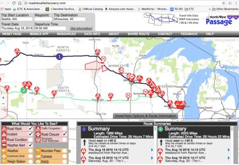
North West Passage Traveler Information Website (roadstosafediscovery.com), the group’s hallmark project, offers travel information for I-90 and I-94 in a single interactive map. In addition to checking weather conditions, road closures and temporary truck restrictions, motorists can find the location of gas stops, rest areas and parks.
The states are currently evaluating a program that allows citizens to report driving conditions so that they can be included in traveler information reporting (a pilot is underway with MnDOT’s 511 system), and another project is comparing winter maintenance practices between corridor states.
“The biggest benefit of this pooled fund study is that it allows MnDOT to see what its neighbors are doing when developing solutions for operational issues. This awareness really helps us make better decisions about our projects at the state level,” said Cory Johnson, Traffic Research Director, MnDOT Office of Traffic, Safety and Technology.
Other major accomplishments:
North and South Dakota 511 callers can select to receive information on Minnesota’s highways.
An online portal for coordination of traffic management center operations, including guidelines, maps and contact information to manage major events across states.
Development of one proposal to hire a contractor to perform work in two states.
Eight states maintain the North West Passage Traveler Information Website, which shows real-time travel information between Wisconsin and Washington along Interstates 90 and 94. A mobile app is under development.
For more than 30 years, the Federal Highway Administration’s (FHWA’s) Transportation Pooled Fund (TPF) Program has been providing state departments of transportation and other organizations the opportunity to collaborate in solving transportation-related problems. The TPF Program is focused on leveraging limited funds, avoiding duplication of effort, undertaking large-scale projects and achieving broader dissemination of results on issues of regional and national interest.
If you have spent any time driving on Minnesota roads and highways lately, you know that road construction work zones are all over the place. They can contribute to traffic delays and require vigilance to ensure the safety of both drivers and workers.
MnDOT and the Minnesota Local Road Research Board (LRRB) are doing their best to make work zones more efficient and safer for crew members and the traveling public alike.
Here’s a roundup of some of the great work zone safety projects under way or recently completed:
City and county workers sometimes have trouble determining how to select the appropriate work zone for low traffic roads. The Minnesota Local Road Research Board (LRRB) recently published two supplemental guidebooks to help local agencies identify the appropriate work zone layout for low-volume urban and rural roadways based on the maintenance activity. The guides are intended to supplement MnDOT’s 2014 Temporary Traffic Control Zone Layouts Field Manual.The LRRB has also requested changes to the field manual for low-volume roadways in a letter to the MN Committee on Uniform Traffic Control Devices.
MnDOT is testing a system on I-94 this summer that it hopes will reduce work zone crashes by raising driver awareness of upcoming congestion. Systems with the same purpose have been tested in rural work zones, but mostly applied to locations where backups were predictable.
The Smart Work Zone Speed Notification System will take a different approach, informing drivers of the speed ahead, as opposed to a variable speed limit system tested previously on I-94, which also detected congestion but provided advisory speeds to drivers. It is envisioned that the new system will have greater success in reducing rear-end crashes on large, urban freeway work zones.
The new system is being tested and evaluated on I-94, east of downtown St. Paul, during work to replace and repair the roadway.
Police enforcement and speed limits are the main method of reducing the speed of drivers in Minnesota work zones. While this practice is effective, reducing speeds by approximately 10 to 15 mph, it is not practical to staff every work zone with law enforcement. As an alternative, some states are using automated speed enforcement cameras in work zones.
Automated speed enforcement cameras have been shown to reduce speeds in work zones, but such research did not evaluate how the cameras impact driver attention.
This study explored driver awareness and found that automated speed enforcement cameras in work zones are not a source of driver distraction. It also revealed differences in work zone driving behavior: Older drivers were least able to follow another vehicle closely, while younger drivers were least likely to monitor their speed carefully.
Accurate estimation of delays caused by lane closures on highways is critical important to effectively manage traffic flows around work zones.
A recent study, completed in March 2016, improves methods for estimating reduced traffic capacity and diversion rates for highway work zones.
Researchers analyzed traffic patterns from past work zones in the Twin Cities metro area and were able to develop a tool that can estimate estimate traffic diversion for a given work zone.
The next step is an implementation project to test and streamline the software.
Work zone intrusions — when traveling vehicles enter the work space of a work zone — are a clear safety concern even if they do not result in an accident, and they may indicate locations where future accidents are likely.
MnDOT was interested in learning how other state DOTs collect work zone intrusion data, both the technology used for data collection and the specific information they collect.
This Transportation Research Synthesis (TRS), completed in June 2015, surveyed state DOTs and conducted follow-up interviews with states that collect work zone intrusion data. The survey found that the relatively small number of states that do collect intrusion data typically do so via paper or electronic form.
As a result of the TRS, a recently funded research project proposes to develop a simple method to track and gather information on work zone intrusions. The aim of this process will be to produce a reporting interface (in the same vein as the Crash Report Usability And Design Project for the Department of Public Safety) that gathers essential information without being onerous to work crews.
Training was provided to introduce MnDOT maintenance workers to Automatic Flagger Assistance devices, which can improve safety in work zones by allowing flaggers to provide traffic guidance without having to be in the flow of traffic.
Using a remote control, a single worker can easily operate two AFADs simultaneously, freeing up personnel to perform other tasks and speed up the completion of a road project, the pilot study found. MnDOT estimates that the resulting cost savings can cover an AFAD’s purchase costs within two years.
MnDOT has planned a project to determine whether it is feasible to use a self-propelled device to push or pull an AFAD so it can be used in moving operations such as patching potholes or cracks, which make up more than half of MnDOT’s flagging operations.
In a study released in February 2014, researchers developed and tested a new system to provide audible messages to visually impaired pedestrians for navigating work zones.
The system uses Bluetooth beacons attached to work zone infrastructure that sends messages to a pedestrian’s smartphone app rather than the traditional method of beeping buttons that announce a message when pressed.
By creating a tactile vibration and sound, rumble strips effectively alert distracted drivers to potential danger. However, they are not suitable for moving operations because repositioning them is too labor-intensive. MnDOT needed a method of alerting drivers about upcoming work zones that is more dynamic than
static signs but is portable and can be used in a moving work zone.
The Intelligent Drum Line system, developed in a 2012, could significantly improve work zone safety by relaying audible and visual warnings from traffic drums to speeding drivers as they approach. Further development is needed to ensure the system is cost-effective and portable to serve MnDOT’s needs.
In the above video, University of Minnesota-Duluth Associate Professor Ryan Rosandich tests a prototype of a robotic arm he developed to paint messages and markings on roadways. He calls the machine “The MnDOT Robot.”
During a test run in October 2015, the MnDOT robot painted a right-turn arrow and the word “ahead” on pavement at MnDOT’s Pike Lake station in Duluth.
Rosandich hopes commercial companies will show an interest in further developing his proof-of-concept technology into something that road authorities can use regularly to make work easier, faster and safer for their employees.
Companies interested in commercializing this technology can contact Andrew Morrow at amorrow@umn.edu.
Editor’s Note: The paint used in the above demonstration was diluted due to the cold weather at the time of the demonstration and does not reflect the condition of the paint expected in a typical application.
While some interns spend their days making copies and coffee runs, Caitlin Johnson spent her summer internship working on a research project exploring ways to improve safety in work zones.
Johnson, a fifth-year civil engineering student, is one of eight undergrads from the University of Minnesota who participated in this year’s Summer Transportation Internship Program.
Interns worked at MnDOT for 10 weeks and gained valuable transportation-related experience in areas ranging from designing roadways to measuring pavement movement. The program, offered jointly by CTS and MnDOT, is now in its fourth year.
This year’s participants included the following students, working in these MnDOT offices:
Caitlin Johnson, Office of Traffic, Safety and Technology
Mamadou Mbengue, Office of Environmental Stewardship
Johnson says her internship at MnDOT gave her the opportunity to study a topic that hasn’t been explored in-depth in the past and present those findings to industry professionals, including staff from the Federal Highway Administration. Luke Horsager, a civil engineering senior, spent his internship with the Bridge & Hydraulics Office equipping MnDOT boats with new GPS and Bluetooth software used for river mapping and monitoring bridge scour. He says he enjoyed gaining hands-on experience with the technology.
Heidi Gray, a MnDOT Metro District designer who supervised intern Ellie Lee in the Office of Design, says the internship program is valuable not only for the students, but also for the supervisors and MnDOT as a whole. While the interns gained important hands-on work experience and made valuable professional connections, MnDOT supervisors were introduced to talented young professionals.
“It’s really good to get young people in here and teach them what MnDOT is all about,” Gray says. “I personally have enjoyed the opportunity to teach and pass along what I know. It’s a good refresher.”
Application materials for the 2016 Summer Transportation Internship Program will be available on the CTS website in early November.
Joint article produced with MnDOT Research Services
Minnesota developed the Strategic Highway Safety Plan a decade ago, as the nation set a goal of reducing roadway deaths to less than one person per 100 million vehicle miles traveled. Last year, the nation still hadn’t reached this milestone (1.1 deaths occurred per 100 million miles), but Minnesota had lowered its fatality rate to 0.63 deaths (down from 1.48 deaths from 20 years ago).
“When I look at what Minnesota has done over the last 15 years compared to other states, we’re one of the few states that has a pretty consistent downward trend [in fatal crashes],” said Brad Estochen, MnDOT state traffic engineer, who gave an update on the highway safety plan during a recent presentation at the Roadway Safety Institute. “I think we’re doing some unique things here that have given us these results.”
These steps, Estochen says, have included passing a primary offense seatbelt law (seatbelt usage is now above 90 percent), investing in strategic safety infrastructure like high-tension cable median barriers and focused enforcement of DWI, speed and seatbelt laws.
Developing a plan
To best understand the risk factors for fatal and serious injury crashes, the state combined real-life crash data with input from professionals in engineering, law enforcement, emergency medical services, as well as everyday road users. The results showed that most crashes in the state involve multiple factors—such as road conditions, driver impairment and driver age.
Estochen said this approach of analyzing data and gaining stakeholder perspectives provided new insights into the dynamic causes of fatal and serious injury crashes.
In conjunction with the Departments of Health and Public Safety, MnDOT created a highway safety plan aimed at both professional stakeholders and the community that identified critical strategies for reducing serious traffic incidents. It has been updated in 2007 and 2014, most recently.
MnDOT also created a complimentary document for every county and MnDOT district (respectively called the county safety plan and district safety plan) to help local agencies identify locations and potential projects for reducing fatalities.
“We were the first state to take the SHSP concept to the local level. It was identified as a noteworthy practice by FHWA and other states are now starting to engage locals in developing specific plans for their use and implementation,” Estochen said.
The highway safety plan is an integral part of Toward Zero Deaths, the state’s cornerstone traffic safety program that has a goal of reducing fatalities to less than 300 per year by 2020.
Overall, Estochen said one of the best ways to reduce crashes in the state is to promote a culture of traffic safety — something he hopes the highway safety plan contributes to.
“Creating a traffic safety culture has nothing to do with building bigger and better roads,” he said. “It really has to do with making us as a state, as a community and as individuals responsible for our actions.”
In July, CTS introduced the next generation of the workforce to transportation topics and careers during a two-week summer program. Thirty students entering seventh through ninth grade attended the CTS-hosted National Summer Transportation Institute, where they got hands-on experience with topics ranging from distracted driving to aeronautics to traffic management.
As part of the program, attendees toured campus, visited the U of M’s transportation-related labs, and learned tips on researching, studying, public speaking, and writing. In addition, participants learned about many aspects of transportation, including human factors, roadway safety, bridge design, surveying, and traffic simulation.
This slideshow requires JavaScript.
The camp also included outings to several MnDOT facilities, UPS, Metro Transit, the Minneapolis–St. Paul International Airport, the Minnesota Transportation Museum, and boat tours of the St. Croix River Crossing construction site and St. Paul Port Authority.
Highlights for attendees included riding the light rail and going behind the scenes in a Metro Transit control room, watching airplanes take off and exploring maintenance equipment at the airport, getting up close to bridge construction on the St. Croix River Crossing boat tour, and using a driving simulator to learn about distracted driving at UPS.
“I really enjoyed using the driving simulators,” said one of the ninth-grade program participants. “It was a hands-on experience that truly taught me the dangers of texting while driving and how much harder it really is.”
In post-program evaluations, parents reported that their children had learned valuable information about transportation topics, careers, and related education opportunities.
“This was one of the best camps we have ever experienced,” one parent said. “There was always a plan for college, and this program increased enthusiasm, preparedness, and maturity.”
“[The program] opened up my daughter’s horizon for future career choices and major focus areas after high school,” another parent said.
The program was sponsored by CTS with funding from the Federal Highway Administration administered by the Minnesota Department of Transportation (MnDOT).


 Police enforcement and speed limits are the main method of reducing the speed of drivers in Minnesota work zones. While this practice is effective, reducing speeds by approximately 10 to 15 mph, it is not practical to staff every work zone with law enforcement. As an alternative, some states are using automated speed enforcement cameras in work zones.
 Work zone intrusions — when traveling vehicles enter the work space of a work zone — are a clear safety concern even if they do not result in an accident, and they may indicate locations where future accidents are likely.
 In a study released in February 2014, researchers developed and tested a new system to provide audible messages to visually impaired pedestrians for navigating work zones.
 By creating a tactile vibration and sound, rumble strips effectively alert distracted drivers to potential danger. However, they are not suitable for moving operations because repositioning them is too labor-intensive. MnDOT needed a method of alerting drivers about upcoming work zones that is more dynamic than


