Interstates 90 and 94 between Wisconsin and the state of Washington are major corridors for commercial and recreational travel. Extreme winter weather conditions, prevalent in the northern states within this corridor, pose significant operational and travel-related challenges. Recognizing the value of coordinated, cross-border collaboration for ITS deployment, Minnesota spearheaded the development of a transportation pooled fund study, called North/West Passage, in 2003.
The eight states – Minnesota, Idaho, Montana, North Dakota, South Dakota, Washington, Wisconsin and Wyoming – involved in the study are predominantly rural and face similar transportation issues related to traffic management, traveler information and commercial vehicle operations. They developed an ITS Integrated Work Plan and have completed nine work plans containing 50 projects.
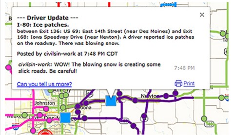
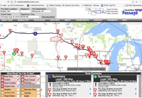
North West Passage Traveler Information Website (roadstosafediscovery.com), the group’s hallmark project, offers travel information for I-90 and I-94 in a single interactive map. In addition to checking weather conditions, road closures and temporary truck restrictions, motorists can find the location of gas stops, rest areas and parks.
The states are currently evaluating a program that allows citizens to report driving conditions so that they can be included in traveler information reporting (a pilot is underway with MnDOT’s 511 system), and another project is comparing winter maintenance practices between corridor states.
“The biggest benefit of this pooled fund study is that it allows MnDOT to see what its neighbors are doing when developing solutions for operational issues. This awareness really helps us make better decisions about our projects at the state level,” said Cory Johnson, Traffic Research Director, MnDOT Office of Traffic, Safety and Technology.
Other major accomplishments:
- North and South Dakota 511 callers can select to receive information on Minnesota’s highways.
- An online portal for coordination of traffic management center operations, including guidelines, maps and contact information to manage major events across states.
- Development of one proposal to hire a contractor to perform work in two states.
For more than 30 years, the Federal Highway Administration’s (FHWA’s) Transportation Pooled Fund (TPF) Program has been providing state departments of transportation and other organizations the opportunity to collaborate in solving transportation-related problems. The TPF Program is focused on leveraging limited funds, avoiding duplication of effort, undertaking large-scale projects and achieving broader dissemination of results on issues of regional and national interest.


 Police enforcement and speed limits are the main method of reducing the speed of drivers in Minnesota work zones. While this practice is effective, reducing speeds by approximately 10 to 15 mph, it is not practical to staff every work zone with law enforcement. As an alternative, some states are using automated speed enforcement cameras in work zones.
 Work zone intrusions — when traveling vehicles enter the work space of a work zone — are a clear safety concern even if they do not result in an accident, and they may indicate locations where future accidents are likely.
 In a study released in February 2014, researchers developed and tested a new system to provide audible messages to visually impaired pedestrians for navigating work zones.
 By creating a tactile vibration and sound, rumble strips effectively alert distracted drivers to potential danger. However, they are not suitable for moving operations because repositioning them is too labor-intensive. MnDOT needed a method of alerting drivers about upcoming work zones that is more dynamic than