Category Archives: Multi-modal

New guidebook, training to facilitate safer pedestrian crossings

City and county engineers often struggle with how to respond to safety concerns about pedestrian crossings, with no scientific method for evaluating them.

In Long Lake, for example, the police department received numerous complaints about the safety of a particular pedestrian crossing. But when the crossing was videotaped, no one was observed using it.

This example — which was part of a research project funded by the Local Road Research Board — exemplifies the difficulties local governments face when they receive requests for a stop sign or signals at a crossing.
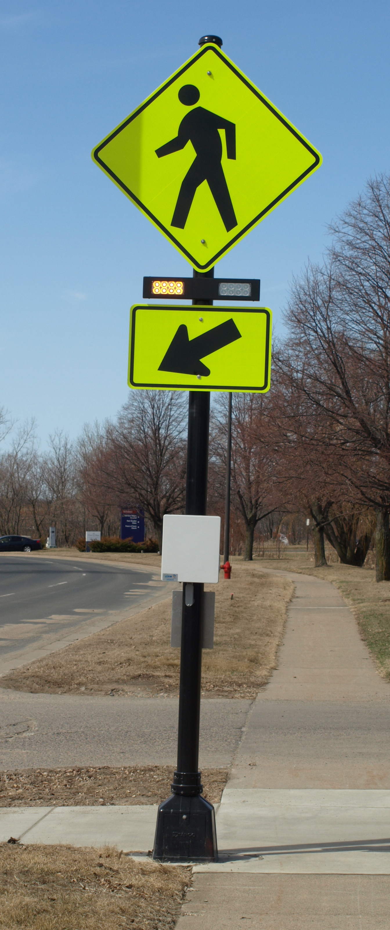
A pedestrian crossing control device.

A new manual and June 5 training workshop being held by the Minnesota Local Technical Assistance Program will provide cities and counties with step-by-step tools for evaluating a pedestrian crossing and identifying whether improvements are warranted.

The soon-to-be released guidebook* recommends when to install marked crosswalks and other enhancements based on the average daily vehicle count, number of pedestrians, number of lanes and average vehicle speed. It guides users how to rate a crossing for pedestrian service, and includes a flow chart to assist in decision-making.

The training is unique because it is based on actual video footage of existing crosswalks and the pedestrians which use them.

No guidance

Although vehicles are legally required to stop for pedestrians crossing at intersections and within marked crosswalks, they don’t always yield the right-of-way. And areas with high traffic volumes may not have adequate gaps for pedestrians to cross safely, leading to risk-taking.

Alan Rindels, a MnDOT research engineer, had previously looked for a methodology to evaluate a crosswalk’s effectiveness, but could not find an appropriate engineering analysis.

“What I kept coming up with were results based on the experience of an engineer or planner for what they ‘felt’ was a better crosswalk, such as additional pavement markings, lights or maybe a signal system,” he said.

Rindels finally found guidance in a Transportation Research Board webinar two years ago. Based on that, he asked the LRRB to develop a training methodology for Minnesota practitioners.

Uncontrolled pedestrian crossings

Unless specifically marked otherwise, every intersection is a pedestrian crossing, regardless of the existence of crosswalk markings or sidewalks. At mid-block locations, crosswalk markings legally establish the pedestrian crossing. Uncontrolled pedestrian crossings (which the guidebook focuses on) are locations that are not controlled by a stop sign, yield sign or traffic signal.

Defining where to place pedestrian crossing enhancements — including markings, signs and or other devices — depends on many factors, including pedestrian volume, vehicular traffic volume, sight lines and speed.

The LRRB developed a worksheet that engineers can use to evaluate an uncontrolled pedestrian crossing location in a systematic way, in accordance with the 2010 Highway Capacity Manual. Users note the level of lighting, distance from the nearest all-way stop and whether another location might serve the same pedestrian crossing more effectively.

The guidebook’s 11-step evaluation can identify what level of treatment is appropriate, ranging from overhead flashing beacons and traffic calming devices, such as curb bump-outs, to more expensive options like building overpass or underpass.

Hennepin County Senior Transportation Engineer Pete Lemke, who went through pre-training, said the guidebook will help engineers measure the pedestrian experience by “quantifying the delay at non-signalized intersections.”

“It will inform how we respond to concerns — whether that response is ‘the crossing fits the needs of what’s there’ or ‘we need to make changes or enhancements,'” he said.

Further Resources

Putting Research Into Practice: A Guide for Pedestrian Crossing Treatments at Uncontrolled Intersections – Technical Summary (1 MB, 2 pages); Final Report.

Training workshop – June 5 (register here)

* Consultant Bolton & Menks prepared the guidebook with guidance from a 21-member project team that included University of Minnesota researchers and engineers from the city of Eagan, Hennepin County, Carver County, Scott County, MnDOT, the Center for Transportation Studies and the Federal Highway Administration.
Bicycle and pedestrian-counting project wins CTS partnership award

(Feature image courtesy Michael McCarthy, Center for Transportation Studies.)

Earlier this year, we wrote about the Minnesota Bicycle and Pedestrian Counting Initiative, a project that developed guidelines and protocols to help transportation planners accurately count non-motorized traffic. This groundbreaking research involved a diverse partnership of state and local officials, University of Minnesota faculty, and private and nonprofit organizations.

On Wednesday, April 23, the project team (photo above) was honored with an award from the Center for Transportation Studies. Team members accepted the CTS Research Partnership Award in a ceremony at the McNamara Alumni Center in Minneapolis. The award is given each year to projects that have resulted in “significant impacts on transportation” and that draw on “the strengths of their diverse partnerships” to achieve their results.

The video below, produced by CTS, explains the importance of the project. MnDOT is now in the process of implementing the research results by installing permanent counters and using portable counters in select locations around the state. MnDOT plans to use the information for a variety of purposes, including planning, safety analysis, investment planning and quality-of-life analysis.

Project team members will present their research findings at the North American Travel Monitoring Exposition and Conference in July. The conference’s focus is on “Improving Traffic Data Collection, Analysis, and Use.”

*Bonus: Read about last year’s Research Partnership Award-winner, a MnDOT-led, multi-state effort to reduce low-temperature cracking in asphalt pavements.

Learn more about the project:

Bike to Work Day: progress in Minnesota, but miles to go

By Greg Lindsey

This blog post by University of Minnesota Professor Greg Lindsey was originally posted on the CTS Conversations blog.

April 9 is national Bike to Work Day, a day to celebrate those who choose bicycling as their principal mode of transportation for commuting, and a time to encourage more people to consider this healthy, efficient transportation option. Minnesota has much to celebrate in terms of bicycle commuting. Bike-Walk Twin Cities and Transit for Livable Communities are wrapping up the National Non-Motorized Pilot Program, a federally funded program to demonstrate the potential to increase biking and walking through focused investment in infrastructure and other interventions. Bicycle commuting rates in Minneapolis have climbed to 4.5%, and Minneapolis now ranks 20th in the nation in bicycle commute share. This is a noteworthy achievement, especially considering our notorious winter weather. These achievements, along with others such as the success of Nice Ride, our pioneering bike share program, have contributed to Minneapolis being named America’s most bike-friendly city by Bicycling Magazine. Celebration of these achievements – which represent hard work by hundreds of individuals and thousands of commuters – certainly is warranted.

But we only need look across municipal boundaries to know we had better put more energy into encouraging bicycling than into celebration. Bicycle commute rates in St. Paul remain below 2% less than half the Minneapolis rate, and rates in most suburban, exurban, and rural communities remain even lower. And the story remains essentially the same for all types of bicycle trips. Jessi Schoner, a doctoral candidate in the Department of Civil Engineering, is analyzing non-motorized mode shares for all trips recorded the Metropolitan Council’s recent Travel Behavior Inventory. Her analyses show that bicycling remains an urban phenomenon, with the share of all trips taken by bicycling highest in Minneapolis, followed by St. Paul, and then suburban and outlying communities. Why is this so? Better infrastructure no doubt is part of the reason, but there likely are other reasons, including housing patterns, access to employment, socio-demographic factors, and culture. Additional research is needed.

But this leads to additional reasons to be optimistic this Bike to Work Day: the commitments made by the Minnesota Department of Transportation (MnDOT) to foster multi-modal transportation systems and the agency’s investments in research to increase understanding of bicycle traffic patterns. In 2013, as part of the Minnesota Bicycle and Pedestrian Counting Initiative, MnDOT funded the installation of the state’s first two automated, continuous in-street bicycle counters. These counters, which monitor bicycle traffic around the clock, 365 days per year, will provide new insights into the bicycle traffic volumes and their daily and seasonal patterns. While bicycle traffic monitoring in Minnesota is only in its infancy, it represents progress towards establishing the evidence base we need to determine how to make bicycling safer and to invest in bicycle infrastructure.

And so celebrate this Bike to Work Day and thank your fellow Minnesotans for all they have accomplished. But also take time to reflect on the work that needs to be done to improve opportunities for cycling throughout the state, for we have miles to go.

Greg Lindsey is a professor at the University of Minnesota Humphrey School of Public Affairs. His areas of specialty include environmental planning, policy, and management. His current research involves studies of the relationship between the built environment and physical activity, specifically factors that affect the use of pedestrian and cycling infrastructure. Lindsey presented some of his bicycle and pedestrian data collection research at the 2014 Minnesota Transportation Conference held March 4-6.

Smartphone app guides blind pedestrians through work zones (updated)

Each year, approximately 17 percent of road construction work zone fatalities nationwide are pedestrians.

At special risk are the visually impaired, who rely on walking and public transportation to get around.

A major challenge  for them is crossing the street — which is even more difficult if an intersection is torn up.

MnDOT has invested significant effort to accommodate pedestrians, particularly those with disabilities, in temporary traffic control situations. This includes requiring temporary curb ramps and alternative routes when a sidewalk is closed.

Researchers, funded by MnDOT, have now developed a cell phone application to guide blind pedestrians around a work-zone.

Illustration of Bluetooth beaconplacement at decision points around a work zone.
Illustration of Bluetooth beacon placement at decision points around a work zone.

Building on previous work to provide geometric and signal timing information to visually impaired pedestrians at signalized intersections, the smartphone-based navigation system alerts users to upcoming work zones and describes how to navigate such intersections safely.

The smartphone application uses GPS and Bluetooth technologies to determine a user’s location. Once a work zone is detected, the smartphone vibrates and announces a corresponding audible message. The user can tap the smartphone to repeat the message, if needed.

The federal government strongly encourages states to provide either audible warnings or tactile maps at work zones where visually impaired pedestrians are expected to be impacted.

“The smartphone application is a step in that direction,” said MnDOT technical liaison Ken Johnson. “It’s a way to see if this type of way-finding device would work.”

Since smartphone use is still limited, the state is also interested in special equipment that could relay the audible warnings at affected work zones.

“However, smartphone use is increasing in the general population, as well as with persons with disabilities, and there will likely be a day when it will be rare to not have a smartphone and this tool could meet road agency needs,” Johnson said.

Before developing the smartphone application, researchers surveyed 10 visually impaired people about their experiences at work zones and what types of information would be helpful in bypass or routing instructions.

The University of Minnesota research team, led by Chen-Fu Liao, tested the smartphone application by attaching four Bluetooth beacons to light posts near a construction site in St. Paul.

Additional research is now needed to conduct experiments with visually impaired users and evaluate system reliability and usefulness.

*Update 4/29/2014: Check out this story from KSTP on the app.

More information

Development of a Navigation System Using Smartphone and Bluetooth Technologies to Help the Visually Impaired Navigate Work Zones Safely — Final Report (PDF, 1 MB, 86 pages)

Three common questions about bike lanes, answered

If you’ve ever driven near a bike lane and not known what to do, you’re not alone.

A forthcoming video from the Local Road Research Board seeks to answer common questions about on-street bike lanes and help bicyclists and motorists better understand the rules. The video is due to be released this spring; in the meantime, we thought we’d give you a sneak preview by addressing three common misconceptions about bike lane rules and safety. 

1) Are bicyclists required to use a bike lane, when present?

No. Although bike lanes usually provide the smoothest, safest and most efficient method of transportation — for everybody — they are not required to use them. They are allowed to ride outside bike lanes to make turns or avoid debris, and they still have the option of using an adjacent trail where available.

2) Are vehicles allowed to enter bike lanes?

Yes, but only to park or turn onto a driveway or street. Motorists should treat bike lanes like any other lane of traffic and yield to approaching bicyclists, but they do have the right to enter bike lanes when turning.

3) Do bicyclists have to follow the same rules as motorists?

Yes. Bicycles are considered vehicles under Minnesota state law and have the same rights and responsibilities. Cyclists are required to obey stop signs and signal their turns, just like motorists.

A federal project funded 75 miles of new bike lanes in four communities, including Minneapolis.
A recent federal project funded 75 miles of new bike lanes in four communities, including the city of Minneapolis. Biking in these areas increased 50 percent; 7,700 fewer tons of carbon dioxide were emitted and gas consumption was reduced by 1.2 million gallons. (Source)

Watch for the LRRB’s new bike safety video on Crossroads this spring. In the meantime, check out MnDOT’s tips on bicycle safety.

Demonstration project helps truck drivers find safe places to park

With freight traffic increasing on U.S. roadways, commercial truck drivers often struggle to find safe and legal places to park. If parking spaces are not available at a nearby rest area or truck stop, drivers may be forced to pull over in unsafe locations or continue driving and become dangerously fatigued. Drivers may also risk violating federal hours-of-service rules, which require them to rest after 11 hours of driving.

In response to this issue, a team from MnDOT, the University of Minnesota, and the American Transportation Research Institute
 is developing a system that can identify available truck parking spaces and communicate the information to drivers—helping them determine when and where to stop. System benefits include improved safety, reduced driver fatigue, and better trip management.

The system uses a network of digital cameras suspended above a parking area to monitor space availability. Image processing software developed by researchers at the U of M’s computer science and engineering department analyzes the video frames and determines the number of available spaces.

As part of a demonstration project funded by MnDOT and the Federal Highway Administration, the project team is installing the system at three MnDOT rest areas and one private truck stop on I-94 west and northwest of the Twin Cities.

The U of M research team first installed the system in late 2012 at the the Elm Creek Rest Area, two miles north of Interstate 494 on I-94. As of early 2014, the system has been installed at an additional rest area, and a third site is in progress.

Next steps for the project include implementing several mechanisms that will communicate parking information to truck drivers. First, the team plans to install variable message signs along I-94 this spring. Also in the works are an in-cab messaging system and a website.

Overall results of the demonstration project will help the team determine whether this technology holds promise for use in other corridors throughout the nation.

Read the full article in the February issue of Catalyst.

Do streetcars support commercial development? New Orleans results say yes

New streetcar lines are in the planning stages in Minneapolis and St. Paul. Proponents cite not only the lines’ ability to strengthen the transit system, but also their potential as catalysts for development. Estimating the impacts of streetcars is challenging, however, as most U.S. lines operate in downtown areas with many interrelated factors at play. A recent U of M research project examined the issue through the prism of one city’s experience: post-Katrina New Orleans.

The team—research fellow Andrew Guthrie and Assistant Professor Yingling Fan of the Humphrey School of Public Affairs—analyzed building permits near streetcar stops in the downtown business district and in several urban neighborhoods.

“Hurricane Katrina allowed—or required—more redevelopment to occur at a faster pace than 
normal, potentially allowing existing streetcar lines’ latent development impacts to appear,” Guthrie says. “This created an unfortunate yet rare opportunity for study.”

streetcars

The researchers estimated how the frequency of commercial and residential permits changed with distance from streetcar stops, controlling for hurricane damage, proximity to existing commercial areas, and pre-Katrina demographics.

They found that throughout the system, building permits strongly reflect the distance to stops—and that commercial and residential permits move
 in opposite directions within the first 750 feet.

Commercial permits declined the further away the location was from a stop. In residential areas, commercial permits show variation depending on neighborhood characteristics. The number of neighborhood residential permits rose about 24 percent with every 100 feet from a stop.

Based on their results, Guthrie and Fan conclude that traditional streetcar lines can help increase commercial development not just in downtown business districts, but in other urban areas as well. The findings also indicate that streetcars
 shape development in urban neighborhoods in
 a fundamentally different fashion than light rail.

Read the full article in the January issue of Catalyst.

Exploring Nice Ride job accessibility and station choice

Although bike share systems are becoming more popular across the United States, little is known about how people make decisions when integrating these systems into their daily travel.

In a study funded by CTS, researchers from the U of M’s civil engineering department investigated how people use the Nice Ride bike share system in Minneapolis and St. Paul. The researchers examined how Nice Ride affects accessibility to jobs and developed a model to predict station choice.

In the first part of the study, the researchers created maps showing accessibility to jobs by census block for both Nice Ride and walking—as well as the difference between the two—at time thresholds ranging from 5 to 55 minutes.

Overall, in blocks with both Nice Ride and walking job accessibility, Nice Ride provides access to 0.5 to 3.21 times as many jobs as walking.

By comparing Nice Ride to walking, the study demonstrated that walking can successfully be used as a baseline to show how a bike share system improves job accessibility. The results also pinpointed when and where Nice Ride had the strongest accessibility advantage over walking.

“This type of information can be used by bike share system planners to identify where new stations could be built to maximize their impact on job accessibility,” says grad student Jessica Schoner, a member of the research team.

In addition, the team developed a theoretical model for bike share station choice. The model considers users’ choice of a station based on their preference 
for the amount of time spent walking, deviation from the shortest path (the closest station may not be in the direct path of the person’s destination), and station amenities and neighborhood characteristics.

Findings show that people generally prefer to use stations that don’t require long detours to reach, but a station’s surroundings also play an important role. Results also indicate that commuters value shorter trips and tend to choose stations that minimize overall travel time.

According to Schoner, understanding people’s station preference can help provide guidance to planners that want to expand or optimize a bike share system.

Read the full article in the January issue of Catalyst.