Newly developed software has drastically reduced the amount of time and effort required by MnDOT’s Regional Transportation Management Center (RTMC) to analyze congestion in the Twin Cities metropolitan area.
Developing MnDOT’s annual Metropolitan Freeway System Congestion Report used to be a manual process that could be applied to only a portion of the large quantity of data generated by in-pavement sensors.
The new Highway Automated Reporting Tool now automatically imports and cleans data to produce a report about the percentage of network miles congested during peak periods as well as three new reports on other performance measures.
The tool will help MnDOT engineers and planners better develop congestion reduction strategies and determine the most cost-effective investments in the network.
From RTMC’s control room, engineers monitor and manage 400 miles of Twin Cities freeway traffic using data from thousands of in-pavement sensors.
“Before HART, it took months to analyze freeway performance using traffic data from only the month of October. Now engineers can quickly analyze data from any time period, significantly improving traffic planning,” said Jesse Larson, Assistant Freeway Operations Engineer for MnDOT’s Metro District Regional Transportation Management Center.
The tool was developed in a MnDOT-funded study led by University of Minnesota researcher John Hourdos.
Note: This article was adapted from the May–June 2014 issue of our Accelerator newsletter. Sign up for your free print or email subscription by clicking here.
Rumble strips alert sleepy and inattentive motorists that they are about to veer off the highway or into the opposite lane of traffic. But the grating noise that prevents collisions can also be annoying to nearby residents.
Around Minnesota, more and more counties are facing push-back as they install shoulder rumble strips on roadways in populated areas. This is because county road shoulders are narrow — leading drivers to frequently hit the rumbles.
“There is a strong concern statewide that these noise complaints will raise enough concern that legislation may be passed reducing their use,” said technical liaison Ken Johnson of MnDOT’s Office of Traffic, Safety and Technology.
A European-developed style of rumble strip, called sinusoidal, could provide Minnesota a new means of warning drivers without as much stray highway noise.
Accident reduction
Rumble strips are patterns ground into asphalt that cause a vehicle to vibrate when its tires come close to the centerline or road edge. They help prevent lane departure crashes, which account for more than 50-percent of fatalities on the road system.
The sinusoidal rumble (below) has a sine wave pattern ground into the pavement, while the traditional rumble strip (top photo) doesn’t follow a wave pattern.
Creation of a Sinusoidal rumble strip. Photo courtesy of the Wirtgen Group
MnDOT’s Office of Traffic, Safety and Technology plans to test different designs of the Sinusoidal rumble strips to find the one with the highest level of interior vehicle noise and lowest level of exterior vehicle noise.
The navigability of sinusoidal rumbles by motorcycles and bicycles will also be evaluated. The project was recently funded with a research implementation grant from MnDOT’s Transportation Research Innovation Group.
If sinusoidal rumble strips are found to be effective, the chosen design will be used for centerlines and road shoulders in noise-sensitive areas throughout the state highway system. It is anticipated that counties will also adopt the design.
Unlike counties, most of MnDOT’s recent complaints have been for its centerline rumbles, which are required on all rural, high-speed undivided roads in Minnesota, Johnson said.
MnDOT has considered allowing more exceptions due to residential noise concern; however, doing so could result in more fatal and serious crashes. Sinusoidal rumbles are seen as a possible alternative for these noise-sensitive areas.
The Local Road Research Board is also studying different designs of sinusoidal rumble strips in Polk County.
In an effort to encourage more use of safety rest areas and reduce drowsy driving, the Minnesota Department of Transportation is bolstering amenities and plans to install new signage at select rest areas across the state.
Drowsy driving is conservatively estimated to cause at least 1,550 deaths nationwide each year and $12.5 billion in monetary damage.
Motorists would stop more frequently at rest areas if they knew what rest areas offered, according to market research completed in 2009.
MnDOT will design and install highway symbol signs to advertise the amenities at 13 rest areas in a pilot project funded by MnDOT’s Transportation Research Implementation Group.
“We are using this as a way to entice drivers to take a break, pull over and refresh before returning to the road,” said Robert Williams, MnDOT Safety Rest Area Program Manager and the project proponent.
Rest areas in Brainerd and Cass Lake, Minn., can now offer a tourism-related gift shop, thanks to a change in law.
Amenities differ greatly between rest areas within the state, as well as across the country; this depends on when they were built and whether they are located on an interstate, state highway or toll road.
Older, smaller rest areas may only have a bathroom and picnic area, while newer facilities often have features such as children’s play areas, staffed travel counters and dog runs.
In the future, the state may consider new amenities such as gift shops, adult exercise equipment to rejuvenate motorists, electrical vehicle charging stations and perhaps even electrification stations to allow truck drivers to power their TV or refrigerator without idling their vehicle.
Research has found that as the spacing of rest areas increases beyond 30 miles, the number of drowsy driving crashes goes up exponentially, Williams said.
Each sign will advertise up to six amenities.
Proposed Signage
Symbols on each sign will identify up to six amenities, such as in the example above, which depicts an assisted restroom, gift shop, ticket sales, EV charging stations, childrens’ playlot and adult exercise equipment.
MnDOT will evaluate the pilot project to determine if the symbol signs are effective in communicating to travelers the amenities offered at individual rest areas and if the signs were a factor that encouraged them to stop.
If the two-year project goes well, the state may add similar signs to the remaining 39 Class I safety rest areas (those rest areas equipped with flush toilets).
Some of the signs will require a request to FHWA for experimentation. The intent is to install the signs in the summer of 2015 at rest areas on northbound I-35, eastbound I-94, as well as at the Brainerd Lakes Area Welcome Center on Hwy. 371.
Rest Area Offerings Increase
Although travelers and state DOTs would often like to introduce new amenities, state and federal laws limit what states can offer.
Toll roads and highways built before 1960 (the Interstate era), mostly in the East Coast or Chicago area, have fewer federal restrictions than rest areas in Minnesota and may feature restaurants or convenience stores.
Changes to Minnesota state law in 2005 and recent changes to federal law in MAP-21 now allow limited commercial activities, such as tourism-related gift shops and ticket sales at rest areas. MnDOT and its partners have taken advantage of some of these changes at its visitor centers in Brainerd/Baxter and Cass Lake.
In addition, the state is exploring the concept of using rest areas as transit transfer facilities, where long-distance bus carriers and regional transit lines can exchange passengers.
These transit hubs would shorten travel times for long-distance travelers and allow the rest areas to serve multiple functions while providing a comfortable waiting area for passengers.
The new Roadway Safety Institute, a $10.4 million regional University Transportation Center (UTC) established in late 2013, will conduct a range of research, education, and technology transfer initiatives related to transportation safety. Led by the University of Minnesota, the two-year consortium will develop and implement user-centered safety solutions across multiple modes.
The Institute will be a focal point for safety-related work in the region, which includes Minnesota, Illinois, Indiana, Michigan, Ohio, and Wisconsin. Other consortium members are the University of Akron, University of Illinois at Urbana-Champaign, Southern Illinois University Edwardsville, and Western Michigan University.
Max Donath, professor of mechanical engineering at the U of M, serves as the new Institute’s director. In this month’s issue of the CTS newsletter, Catalyst, Donath shared his vision for theInstitute.
According to Donath, the Institute will focus on addressing regional traffic safety priorities, educating the public, and attracting more professionals to the safety workforce by connecting with students.
Research topics will focus on two key areas, Donath said: high-risk road users and traffic safety system approaches. The goal of this work is to prevent the crashes that lead to fatalities and injuries on the region’s roads.
One unique Institute effort will involve working with American Indian communities in the region to explore and address the unusually high number of motor vehicle crash fatalities on tribal lands. “Our research will work to better understand why this is happening and to develop more effective solutions,” Donath said.
Each year, approximately 17 percent of road construction work zone fatalities nationwide are pedestrians.
At special risk are the visually impaired, who rely on walking and public transportation to get around.
A major challenge for them is crossing the street — which is even more difficult if an intersection is torn up.
MnDOT has invested significant effort to accommodate pedestrians, particularly those with disabilities, in temporary traffic control situations. This includes requiring temporary curb ramps and alternative routes when a sidewalk is closed.
Researchers, funded by MnDOT, have now developed a cell phone application to guide blind pedestrians around a work-zone.
Illustration of Bluetooth beacon placement at decision points around a work zone.
Building on previous work to provide geometric and signal timing information to visually impaired pedestrians at signalized intersections, the smartphone-based navigation system alerts users to upcoming work zones and describes how to navigate such intersections safely.
The smartphone application uses GPS and Bluetooth technologies to determine a user’s location. Once a work zone is detected, the smartphone vibrates and announces a corresponding audible message. The user can tap the smartphone to repeat the message, if needed.
The federal government strongly encourages states to provide either audible warnings or tactile maps at work zones where visually impaired pedestrians are expected to be impacted.
“The smartphone application is a step in that direction,” said MnDOT technical liaison Ken Johnson. “It’s a way to see if this type of way-finding device would work.”
Since smartphone use is still limited, the state is also interested in special equipment that could relay the audible warnings at affected work zones.
“However, smartphone use is increasing in the general population, as well as with persons with disabilities, and there will likely be a day when it will be rare to not have a smartphone and this tool could meet road agency needs,” Johnson said.
Before developing the smartphone application, researchers surveyed 10 visually impaired people about their experiences at work zones and what types of information would be helpful in bypass or routing instructions.
The University of Minnesota research team, led by Chen-Fu Liao, tested the smartphone application by attaching four Bluetooth beacons to light posts near a construction site in St. Paul.
Additional research is now needed to conduct experiments with visually impaired users and evaluate system reliability and usefulness.
Two summers ago, the Minnesota Department of Transportation installed electronic message boards on parts of Interstates 35W and 94 to help warn drivers of crashes and to recommend speed levels during periods of high congestion.
Now, MnDOT would like to use the devices — officially known as Intelligent Lane Control Signs (ILCS) — to advise drivers of sudden stopping or slowing of traffic. Many crashes occur when drivers cannot react quickly enough to these changes.
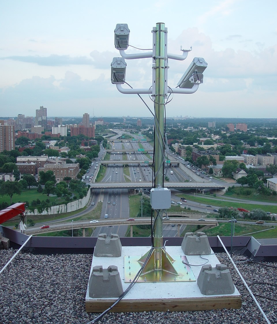
The Minnesota Traffic Observatory (shown in the feature photo above) is developing a warning system to detect such problematic traffic patterns and issue automatic advisories to drivers.
Shock waves on I-94
A section of I-94 in downtown Minneapolis, where southbound I-35W and westbound I-94 converge, may have the highest crash rate in the state.
As shown in the video above, vehicles constantly slow down and speed up here during rush hour, which causes a ripple effect called “shock waves.”
“There’s a crash every two days,” said University of Minnesota researcher John Hourdos, whose students watched over a year’s worth of video footage to document every accident and near accident. “They’re not severe crashes — no one has died for as long as I can remember, and most happen at slow speeds — but they cause a lot of delays for the traveling public.”
When statistics were still being kept, this section of I-94 had the highest number of accidents in the state, with approximately 150 crashes and 400 near crashes observed in 2003.
Researchers developed a program 10 years ago to detect “shock wave” patterns in the traffic, but they couldn’t develop a practical solution until the state invested in electronic message boards.
The University of Minnesota deployed cameras and sensors on three downtown rooftops in 2002 to observe traffic patterns. They provide seamless coverage of the entire area, allowing researchers to watch vehicles from the moment they enter and exit the area. MnDOT has added additional cameras and detectors to watch over this roadway section. For the past year, the combined efforts of MnDOT and the university have provided data from 26 cameras and 12 traffic sensors for the two-mile section that includes the high-crash frequency location.
Thanks to the message boards, Hourdos and his team can now create an automated system to warn drivers when conditions for “shock waves” are greatest, using an algorithm he developed in the previous study.
From downtown Minneapolis rooftops, traffic monitoring equipment detect shockwaves on Interstate 94.
Crosstown interchange
A newer problem that researchers hope to tackle is the lineup of cars on I-35W southbound during rush hour at the newly reconstructed Crosstown interchange.
Although two lanes of traffic are provided for eastbound Highway 62 at the I-35W/62 split, these vehicles must later converge into one lane, due to the Portland Avenue exit. This causes a back-up on the 62 ramp that stretches back to 35W.
Hourdos said developing an algorithm to detect these queues is a different problem than what goes on with I-94, since there is a constant stoppage of cars and no rolling shockwaves.
“Combining the two methodologies will form a more robust solution and a single implementable driver warning system,” Hourdos said.
Researchers might target other problems areas should the state install additional ILCS message boards elsewhere in the Twin Cities.
If you’ve ever driven near a bike lane and not known what to do, you’re not alone.
A forthcoming video from the Local Road Research Board seeks to answer common questions about on-street bike lanes and help bicyclists and motorists better understand the rules. The video is due to be released this spring; in the meantime, we thought we’d give you a sneak preview by addressing three common misconceptions about bike lane rules and safety.
1) Are bicyclists required to use a bike lane, when present?
No. Although bike lanes usually provide the smoothest, safest and most efficient method of transportation — for everybody — they are not required to use them. They are allowed to ride outside bike lanes to make turns or avoid debris, and they still have the option of using an adjacent trail where available.
2) Are vehicles allowed to enter bike lanes?
Yes, but only to park or turn onto a driveway or street. Motorists should treat bike lanes like any other lane of traffic and yield to approaching bicyclists, but they do have the right to enter bike lanes when turning.
3) Do bicyclists have to follow the same rules as motorists?
Yes. Bicycles are considered vehicles under Minnesota state law and have the same rights and responsibilities. Cyclists are required to obey stop signs and signal their turns, just like motorists.
A recent federal project funded 75 miles of new bike lanes in four communities, including the city of Minneapolis. Biking in these areas increased 50 percent; 7,700 fewer tons of carbon dioxide were emitted and gas consumption was reduced by 1.2 million gallons. (Source)
Watch for the LRRB’s new bike safety video on Crossroads this spring. In the meantime, check out MnDOT’s tips on bicycle safety.
With freight traffic increasing on U.S. roadways, commercial truck drivers often struggle to find safe and legal places to park. If parking spaces are not available at a nearby rest area or truck stop, drivers may be forced to pull over in unsafe locations or continue driving and become dangerously fatigued. Drivers may also risk violating federal hours-of-service rules, which require them to rest after 11 hours of driving.
In response to this issue, a team from MnDOT, the University of Minnesota, and the American Transportation Research Institute is developing a system that can identify available truck parking spaces and communicate the information to drivers—helping them determine when and where to stop. System benefits include improved safety, reduced driver fatigue, and better trip management.
The system uses a network of digital cameras suspended above a parking area to monitor space availability. Image processing software developed by researchers at the U of M’s computer science and engineering department analyzes the video frames and determines the number of available spaces.
As part of a demonstration project funded by MnDOT and the Federal Highway Administration, the project team is installing the system at three MnDOT rest areas and one private truck stop on I-94 west and northwest of the Twin Cities.
The U of M research team first installed the system in late 2012 at the the Elm Creek Rest Area, two miles north of Interstate 494 on I-94. As of early 2014, the system has been installed at an additional rest area, and a third site is in progress.
Next steps for the project include implementing several mechanisms that will communicate parking information to truck drivers. First, the team plans to install variable message signs along I-94 this spring. Also in the works are an in-cab messaging system and a website.
Overall results of the demonstration project will help the team determine whether this technology holds promise for use in other corridors throughout the nation.
Read the full article in the February issue of Catalyst.
Minnesotans have grown accustomed to roundabouts as they’ve proliferated throughout the state, but many motorists are still confused by the less common two-lane roundabout.
While roundabouts have been shown to reduce vehicle delay and severe crashes, the few Minnesota cities with this type of multi-lane roundabout have had a prevalence of driver mistakes.
In Woodbury, two such roundabouts were converted into smaller, one-circulating-lane designs due to driver confusion.
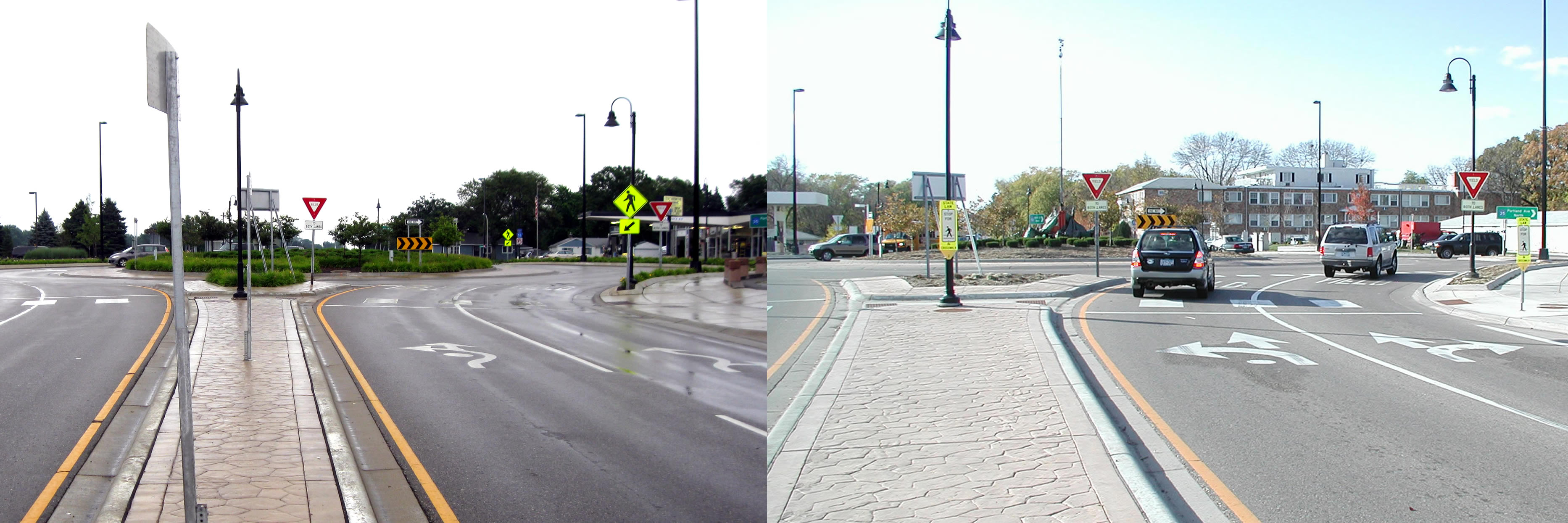
The City of Richfield had no such option at the high-volume Portland Avenue and 66th Street, a formerly signalized intersection that carries about 30,000 vehicles per day. (See video)
Crash-prone and congested prior to its reconstruction in 2008, a two-lane roundabout seemed to be the practical solution for this intersection. But although the roundabout reduced overall crashes, the intersection still had more fender benders than designers were comfortable with, according to City Engineer Kristin Asher.
“The crashes were primarily related to improper left-turns from the outside lane and failure to yield at the entry,” she said.
Not only were drivers unsure which lanes they should use to enter or exit the roundabout, they didn’t know how to respond to other cars inside the roundabout. (See news story)
“People don’t understand they have to yield to both lanes inside the roundabout,” explained University of Minnesota researcher John Hourdos.
The city of Richfield extended the solid lines leading up to the intersection from 50 to 250 feet to encourage drivers to choose the correct lane before entering the roundabout. It also replaced fish-hook-style roundabout signs with traditional lane designation signs and did away with complex striping patterns.
Before and after photos show the original fish-hook style pavement markings, left, that were replaced with a more traditional design. (Courtesy City of Richfield)
Hourdos examined two years of traffic data to see how motorists responded to the improvements that were made in 2011.
He found 50 percent more drivers entered the correct lane from the get-go, which led to a reduction in improper turns within the roundabout. Lane violations were also reduced by 20 percent.
“One of the main problems was drivers didn’t know they have to choose one of the two lanes,” Hourdos explained. “Then once they were inside the roundabout, they were forced to either deviate from their course or commit a violation.”
The city also increased sign visibility to address yielding problems; however, these changes didn’t seem to make a difference.
With state and federal guidelines lacking much guidance for how to sign two-lane roundabouts, the LRRB is funding a new study for three other multi-lane roundabouts: in St. Cloud, at Highway 169/494 and one planned for the future realignment of County Roads 101 and 61 between Chanhassen and Shakopee.