
Category Archives: Traffic and Safety


Reducing confusion at two-lane roundabouts
Minnesotans have grown accustomed to roundabouts as they’ve proliferated throughout the state, but many motorists are still confused by the less common two-lane roundabout.
While roundabouts have been shown to reduce vehicle delay and severe crashes, the few Minnesota cities with this type of multi-lane roundabout have had a prevalence of driver mistakes.
In Woodbury, two such roundabouts were converted into smaller, one-circulating-lane designs due to driver confusion.
The City of Richfield had no such option at the high-volume Portland Avenue and 66th Street, a formerly signalized intersection that carries about 30,000 vehicles per day. (See video)
Crash-prone and congested prior to its reconstruction in 2008, a two-lane roundabout seemed to be the practical solution for this intersection. But although the roundabout reduced overall crashes, the intersection still had more fender benders than designers were comfortable with, according to City Engineer Kristin Asher.
“The crashes were primarily related to improper left-turns from the outside lane and failure to yield at the entry,” she said.
Not only were drivers unsure which lanes they should use to enter or exit the roundabout, they didn’t know how to respond to other cars inside the roundabout. (See news story)
“People don’t understand they have to yield to both lanes inside the roundabout,” explained University of Minnesota researcher John Hourdos.
In a recently completed study funded by the Minnesota Local Road Research Board, researchers from the Minnesota Traffic Observatory examined whether sign and pavement marking changes would improve performance.
The city of Richfield extended the solid lines leading up to the intersection from 50 to 250 feet to encourage drivers to choose the correct lane before entering the roundabout. It also replaced fish-hook-style roundabout signs with traditional lane designation signs and did away with complex striping patterns.
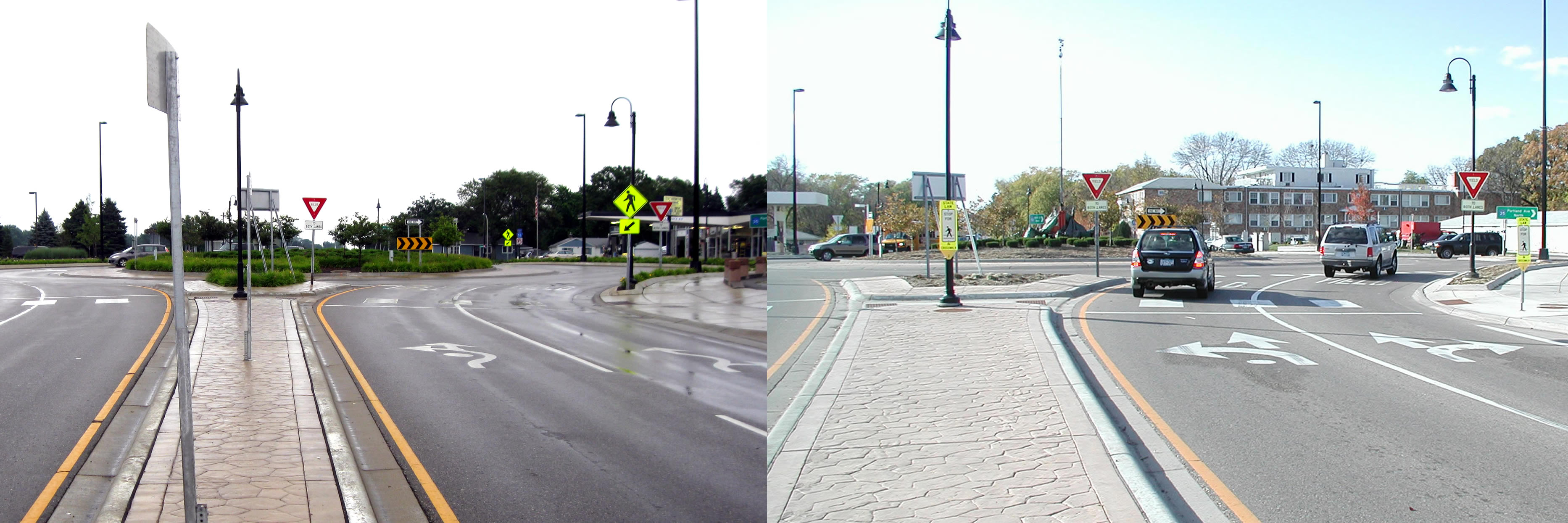
(Courtesy City of Richfield)
Hourdos examined two years of traffic data to see how motorists responded to the improvements that were made in 2011.
He found 50 percent more drivers entered the correct lane from the get-go, which led to a reduction in improper turns within the roundabout. Lane violations were also reduced by 20 percent.
“One of the main problems was drivers didn’t know they have to choose one of the two lanes,” Hourdos explained. “Then once they were inside the roundabout, they were forced to either deviate from their course or commit a violation.”
The city also increased sign visibility to address yielding problems; however, these changes didn’t seem to make a difference.
With state and federal guidelines lacking much guidance for how to sign two-lane roundabouts, the LRRB is funding a new study for three other multi-lane roundabouts: in St. Cloud, at Highway 169/494 and one planned for the future realignment of County Roads 101 and 61 between Chanhassen and Shakopee.
Report: Eff ect of Signing and Lane Markings on the Safety of a Two-Lane Roundabout (PDF, 4 MB, 72 pages)
Update (1/30/2014): Watch the LRRB’s new video on how to navigate a multi-lane roundabout.

New technology aimed at making rural intersections safer
This video above showcases a new kind of intersection conflict warning system being developed for use primarily by local agencies at rural, two-way stop intersections. Called the ALERT System, it uses a simple but ingenious combination of radar, wireless communication and flashing LEDs to alert drivers to the presence of approaching vehicles, thereby helping them identify safe gaps in the cross traffic and avoid potentially deadly collisions.
These types of systems are nothing new; MnDOT and other state DOTs have been developing them for more than a decade under the ENTERPRISE pooled fund program. MnDOT also recently kicked off a three-year project to deploy 20–50 of its Rural Intersection Conflict Warning Systems at selected at-risk intersections across the state. The main difference with the ALERT System is that it’s designed to be cheaper and easier to deploy than existing ICWS technologies. While that might sound like an incremental improvement, the difference for cash-strapped local agencies could be huge.
Since the ALERT System uses solar power, it doesn’t have to be hooked up to the power grid — which means that, in theory, county public works crews could install it themselves. The system also uses a simplified controller that doesn’t require a traffic signal technician to install and maintain, and detects vehicles using radar rather than in-pavement sensors. These factors might encourage greater adoption of ICWS technologies, which studies have shown to reduce both the frequency and severity of crashes.
The project is now in its second phase. It still faces a number of hurdles before could be ready to deploy, but Vic Lund, the traffic engineer for St. Louis County and the project’s main champion, says the results so far have been encouraging. In the video below, Lund shares his thoughts on the project, its challenges and the future of Intelligent Transportation Systems in Minnesota.
Learn more:
- Warning system aims to alert drivers to potential crashes (Catalyst article)
- Advanced LED Warning Signs for Rural Intersections Powered by Renewable Energy (Technical Summary)
- Advanced LED Warning Signs for Rural Intersections Powered by Renewable Energy (Research Report – Phase 1)

Friday fun: Mythbusters pits roundabouts against four-way stop intersections
Transportation research comes in many different forms and methodologies…

Congestion-reduction measures on I-35W: How well do they work?
In an effort to combat congestion in our country’s urban areas, the United States Department of Transportation launched the Urban Partnership Agreement (UPA) program in 2007. The program infused nearly $900 million into transportation-related projects in four cities nationwide, including the Twin Cities metropolitan area. Minnesota’s projects—which include the installation of MnPASS dynamic toll lanes and variable message signs—focused on improving traffic flow in the I-35W corridor between Minneapolis and the city’s southern suburbs.
To understand the effectiveness of measures implemented under the UPA program, a team of University of Minnesota researchers examined three separate but related areas: the effects of a new variable speed limit (VSL) system, the impact of severe weather conditions on road safety, and the behavior and traffic impacts of bus rapid transit operations. Their work was funded by the Intelligent Transportation Systems Institute, a part of CTS.
Key findings included:
- Drivers don’t typically comply with advisory speed limits posted on VSL signs along the I-35W corridor during congested conditions, but they may use them to help gauge and prepare for downstream congestion—resulting in a smoother and possibly safer traffic flow
- Some parts of the corridor’s shoulder lanes—which are opened to traffic during specific times of the day as part of the UPA program—contain low areas that can flood during heavy rains
- Buses traveling on the corridor underuse the MnPASS lane. In addition, bus lane changes (from stations located in the median to those located on the right side of the highway) can generate visible disturbances during moderate and heavy congestion, but they don’t seem to contribute to the breakdown of traffic flow
For more information, read the full article in the September issue of Catalyst.

New LRRB videos focus on work zone safety
The Minnesota Local Road Research Board is a major source of funding for transportation research in the state. Occasionally, it also produces educational videos designed to raise public awareness of important transportation topics.
Two new video offerings from the LRRB (embedded above and below) are focused on save driving in work zones. While not directly research-related, they might prove a useful resource to transportation professionals. More importantly, they serve to remind us all of the very real and dramatic consequences of work zone crashes, of which there are approximately 2,000 per year in Minnesota.
You might want to also check out some of their other recent YouTube offerings, including explanations of why we need stop signs and speed limits, as well as a fascinating look at how potholes are patched.
Testing the waters for mileage-based user fees
 For the fourth year in a row, the State and Local Policy Program of the University of Minnesota’s Humphrey School has partnered with the Texas Transportation Institute (TTI) in sponsoring a Symposium on Mileage-based User Fees (MBUF). This year’s symposium, held in conjunction with the ITS America Conference in Nashville, TN, focused on the technologies involved in charging drivers a fee to use roads based on mileage as well as public concerns such as privacy and implementation challenges. As an indicator of the interest in this issue, the International Bridge, Tolling and Turnpike Association (IBTTA) also held a Transportation Finance and Mileage-Based User Fee Symposium just a week before in Philadelphia, PA, in partnership with the Mileage-Based User Fee Alliance (MBUFA), the Transportation Research Board, and the Humphrey School.
So is the public clamoring for MBUF? Not really. In fact, the public still needs to be convinced that the gas tax will not support our transportation system in the long-run, and that a new user-based system will be required to replace the gas tax in the future if we are to maintain our U.S. transportation infrastructure. The Minnesota Legislature funded an MBUF technology test with 500 Minnesota drivers as well as a policy study and task force to identify issues that must be addressed before an MBUF system could be implemented. The Mileage-Based User Fee Alliance has set up a web page to address five misconceptions about MBUF.
While Minnesota is one of several states that are studying and testing MBUF options, the State of Oregon took the first step toward implementation of a Road Usage Charging system by passing legislation in July 2013. The first step in Oregon will be to recruit 5,000 volunteers for the new Road Usage Charging System. The volunteers will have several option for how to pay the new charge, ranging from simple odometer readings to more advanced technology options that may be combined with other services for drivers. Stay tuned…
Related Links
- Mileage-based user fees for Minnesota?, CTS Catalyst, July 2012
- Mileage-Based User Fee Policy Task Force Report (745 KB PDF)
- Mileage-Based User Fee Policy Study: Supporting Technical Information (MnDOT 2012-11)
This post was written by Lee Munnich, director of the State and Local Policy Program at the University of Minnesota’s Humphrey School of Public Affairs, and originally published on the CTS Conversations blog.

‘Intelligent’ traffic drum could help prevent work-zone tragedies

Work-zone safety is a serious, ongoing challenge for transportation agencies. According to MnDOT, the current three-year average for Minnesota work zones is 1,819 crashes and seven fatalities per year. And that’s not counting near-misses: just talk to anyone who has worked as a flagger, and they will likely have a story about diving into a ditch to avoid being hit by a distracted driver. Consequently, MnDOT is constantly exploring ways to make work zones safer — which brings me to the photo above.
What you’re looking at is no ordinary traffic cone. It’s a prototype of a new warning device called the Intelligent Drum Line system — basically a modified orange traffic drum packed with electronics that can detect speeding drivers and blast them with audiovisual cues to let them know they’re entering the work zone too fast.
Our new technical summary explains the details of the new system, which was developed at the University of Minnesota, with funding and in-kind assistance from MnDOT:
The prototype design uses two modified traffic drums placed 1 to 3 feet from the shoulder of the road and 300 to 400 feet apart. Sensors in the first drum detect vehicles, measure their speed and distance, and communicate this information to the second drum…
When the IDL system detects an oncoming vehicle traveling faster than a threshold speed, the system activates visual warning systems in both drums and initiates a countdown. When the speeding vehicle is approximately 1 second away from the first drum, the system activates an air horn to warn the driver.
As the vehicle passes the first drum, the audible alarm terminates and the system transmits a command to the second drum to start another countdown. When the vehicle is approximately 1 second away from the second drum, the system activates another audible alarm.
Testing of the IDL system at MnROAD has been successful; however, researchers still need to study how drivers react to the system in real-world conditions. Before they can do that, the design will have to be refined so that it can pass Federal Highway Administration crashworthiness tests. On a related note, MnDOT is currently funding a separate University of Minnesota study into which technologies are most effective at capturing drivers’ attention in work zones. The study will include visual and auditory cues similar to the ones used in the IDL prototype.
Learn more:
- Technical Summary (PDF)
- Full Report (PDF)

Best practices for trail crossings – webinar and draft report
Last week, MnDOT Research Services hosted a workshop on a forthcoming report, “Decision Tree for Identifying Alternative Trail Crossing Treatments.” It was broadcast as a webinar, the recording of which is now available online via Adobe Connect:
http://mndot.adobeconnect.com/p8hlfripuwe/
The final report is coming soon, but in the meantime you can see the draft version on our website (link), along with case studies and other related documents.

Free webinar July 9 on best practices for bicycle trail crossings
Intersections between trails and roadways can be dangerous places for bicyclists and pedestrians. Next week, MnDOT Research Services is offering a free webinar on a forthcoming manual designed to help make trail crossings safer.
On Tuesday, July 9, from 1:00 p.m. to 2:30 p.m. (CDT), University of Wisconsin—Madison Professor David Noyce will be conducting a workshop on his forthcoming handbook, “Decision Tree for Identifying Alternative Trail Crossing Treatments.” The project, funded by MnDOT and the Local Road Research Board, aims to identify current engineering state-of-the-practice for trail crossings and provide guidance as to appropriate crossing designs and vehicular and bicycle right-of-way hierarchies.
You can click on the link below at the specified date and time to watch the webinar. No registration is required.
