

Researchers tested sediment control logs in the lab and in the field to determine the relative filtration capabilities of these devices. They also developed design guidelines for correct selection and contributed to ongoing educational efforts.
Continue reading Sediment Control Log Guidance for Field ApplicationsTag Archives: featured

Preparing Roads for Connected and Autonomous Vehicles
Proprietary technologies, industry competition and federal regulatory concerns are slowing the advent of defined standards for connected and autonomous vehicles (CAVs). Researchers investigated the state of CAV implementation to help local agencies begin preparing for the infrastructure needs of these vehicles. CAV-friendly options are considered for eight infrastructure categories. Since truck platooning is the likely first application of this technology, and optical cameras appear imminent as an early iteration of sensing technology, researchers suggest that wider pavement striping and well-maintained, uniform and visible signage may effectively serve the needs of CAVs in the near future while enhancing infrastructure for today’s drivers.
Continue reading Preparing Roads for Connected and Autonomous Vehicles
Bus–Highway Connections Make Transit More Competitive With Driving
Researchers developed a method for associating travel times and travel costs with transit mobility. In an evaluation of bus–highway system interactions, investigators found that park-and-ride lots and managed lanes put suburban and walk-up urban transit options on equal footing. Bus–highway system interactions improve access to job locations and have improved transit access to job sites by about 20 percent compared to automobile access. When wage-related costs are included, the benefit of automobile use over transit use diminishes significantly.
Continue reading Bus–Highway Connections Make Transit More Competitive With Driving
Concrete Grinding Residue Doesn’t Appear to Negatively Affect Roadside Vegetation and Soil
A new MnDOT research study determined that depositing concrete grinding residue (CGR) slurry at specific rates on roadside vegetation and soil may not cause lasting harm to plant growth and soil quality; however, follow-up research is recommended.
Continue reading Concrete Grinding Residue Doesn’t Appear to Negatively Affect Roadside Vegetation and Soil
Rout-and-Seal Offers Slight Cost–Benefit Over Clean-and-Seal Repairs
In a recently completed study, Minnesota researchers compare the performance and cost-benefit of the clean-and-seal versus rout-and-seal techniques for repairing asphalt pavement cracks.
Continue reading Rout-and-Seal Offers Slight Cost–Benefit Over Clean-and-Seal Repairs
New Project: Extreme Flood Risks to Minnesota Bridges and Culverts
Extreme flooding is a threat to Minnesota’s transportation infrastructure and the safety and economic vitality of its communities. A spate of recent flooding events around the state has demonstrated this and heightened the level of concern. Furthermore, climate change — a factor not traditionally accounted for in the design of the state’s infrastructure — is projected to enhance precipitation and the threat of flooding in coming decades.
Given this, MnDOT is undertaking an effort to better predict the threat flooding poses to its bridges, large culverts and pipes, which may be increasingly called upon to convey higher, more frequent flood flows than they were designed for.
The state transportation research program recently launched a two-year extreme flood vulnerability analysis study, which will develop a methodology for characterizing the vulnerability of the state’s bridges, large culverts, and pipes to flooding.
The effort builds upon the previously completed Flash Flood Vulnerability and Adaptation Assessment Pilot Project (2014), which scored bridges, large culverts, and pipes in MnDOT Districts 1 and 6 for flood vulnerability, allowing detailed assessments of adaptation options for each of their facilities to be prioritized.
This new study, which will be conducted by WSP, aims to develop and test ways to enhance the vulnerability scoring techniques used in the previous study and ensure their applicability throughout the state. Researchers will not actually undertake the statewide assessment, but specify an approach that could be used for it. They will also explore how the outputs of the analysis can be incorporated into MnDOT’s asset management systems. The results of this work will be a clear path forward for MnDOT to use for prioritizing adaptation actions — a key step towards enhancing agency resilience and maintaining good fiscal stewardship.
Project scope
The primary intent of this study is to develop a methodology for characterizing the flood vulnerability of bridges, large culverts, and pipes statewide. As part of the development process, the methodology will be tested on a limited, but diverse, set of assets across the state. Following a successful proof of concept, recommendations will be made on how the outputs (i.e., the vulnerability scores) can be incorporated into the state’s asset management systems.
By determining which facilities are most vulnerable to flooding through the techniques developed on this project, MnDOT can prioritize where adaptation measures will make the biggest impact, ultimately decreasing asset life-cycle and road user costs. Without the development of assessment techniques, adaptation measures run the risk of being implemented in a more reactive and/or ad-hoc fashion, with less regard to where the biggest “bang for the buck” can be realized.
This project will produce several technical memorandums, and is expected to be completed in early 2021.

Affordable GPS-Based System Warns Drivers About Lane Departures, Approaching Curves
Researchers have developed an affordable camera-free curve and lane departure warning system that relies on consumer-level GPS, rather than sophisticated, expensive digital maps.
The technology uses cumulative driving trajectory data from GPS points detected every 100 milliseconds to predict driving path trajectories and compare these to mapped curves and lanes. With further development, the system can be used as an inexpensive smartphone app or retail device to warn drivers of lane drift and approaching curves.
“The goal of the project is to reduce lane departure crashes. We viewed this as a seed project and demonstrated that the system can be successful,” said Victor Lund, Traffic Engineer, St. Louis County.
What Was Our Goal?
The Minnesota Local Road Research Board sought research to develop a camera-free curve and lane departure warning system that uses consumer-level GPS capability without reliance on sophisticated, expensive digital maps.
What Was the Need?
Lane departures and run-off-road crashes cause more fatalities and serious injuries in Minnesota than any other accident type.
Many current warning technologies rely on cameras that identify lane position based on pavement markings. In inclement weather, stripes and pavement markings can be difficult or impossible to identify; markings also wear off over time, reducing visibility even in clear conditions. Camera-based lane departure warning systems are also expensive and generally restricted to newer luxury vehicles, making them inaccessible to the general driving public.
Though in-vehicle technology for the public usually falls outside the research interests of the Minnesota Department of Transportation and the Minnesota Local Road Research Board, the agencies have been funding development of lane departure warning technologies to improve driver safety. GPS technologies offer an intriguing path to consumer-level lane departure warning systems.
High-level GPS can be accurate to the centimeter level, but access is restricted and use is expensive. These systems also rely on accurate, lane-level roadway mapping, an elusive data set with high access costs.
What Did We Do?
Researchers began with a literature search of the uses of standard GPS receivers in lane departure and navigation. The research team then developed an algorithm for travel direction that uses standard GPS in a straight road lane departure system to determine driving trajectories at accuracy levels suited to safe driving needs.
Investigators adapted a publicly available digital mapping platform to the same algorithm to identify navigational points along curves and develop the curve lane departure warning system. The team enhanced standard safe distance methods to consider driver reaction time in determining when approach warnings should be issued.
Researchers then brought the two developmental stages of the system together with a warning system that identifies vehicle speed, curvature characteristics and safe speed limits, and calculates distance for driver response times to issue an audible warning to drivers on lane drift and a text warning of when and how much to reduce speed as the vehicle approaches a curve.

For project testing and demonstration, investigators programmed the algorithm into a device with a built-in GPS receiver, connected it to a laptop for messaging and conducted driving tests on Rice Lake Road and on Interstate 35 near Duluth.
“From a technical point of view, this approach works. We developed a warning system with standard GPS that everyone has in a phone or vehicle. This is a lifesaving technology in a sense,” said Imran Hayee, Professor, University of Minnesota Duluth Department of Electrical Engineering.
What Did We Learn?
Finding no research on development of consumer-grade GPS for lane departure purposes, the research team adapted previous work on the relative accuracy of GPS readings from a MnDOT study on wearable GPS for work zone safety.
Researchers adapted a consumer-level GPS device to acquire data at 10-hertz frequency, which yields a GPS position point of 2.7 meters if a vehicle is driven at 60 mph.
The system calculates lane trajectory from cumulative readings and detects turns or drift. The curve warning system plots trajectories and compares these with open-source digital maps with road-level (rather than lane-level) accuracy to anticipate curves.

In road testing, the system issued audio warnings for every one of the approximately 200 lane changes, including curves. For curve warnings, the system scanned for curves at least half a mile ahead and calculated the vehicle’s speed and the distance to a curve to issue a timely text warning of the curve ahead and an advisory speed limit. Additional messages were issued when the vehicle was on the curve and when the curve had ended.
False alarms—warnings issued when the vehicle was not departing its lane—occurred in 10 percent of the tests, usually on sharp curves. Further adjustment of the algorithm and additional testing reduced false alarms significantly as the system accumulated data over multiple uses of the same roadway.
What’s Next?
Investigators filed a patent for the technology and will continue to develop the system. Further refinement of reference road direction information will improve accuracy and safety; the research team has developed a new project to employ vehicle-to-vehicle dedicated short-range communication technology to expand road direction reference data. The system will then need to be adapted for a consumer-level device or a smartphone app for use in any vehicle.
This post pertains to the LRRB-produced Report 2018-34, “Development and Demonstration of a Cost-Effective In-Vehicle Lane Departure and Advanced Curve Speed Warning System,” published December 2018.

New Resource for Using Cone Penetration Testing in Geotechnical Design
Designing foundations for bridges and pavements requires understanding the soil conditions and properties at the site. One of the best methods for calculating site conditions is the cone penetration test (CPT), in which a rod with a cone-shaped tip outfitted with sensors is driven into the soil. Engineers attach more rods to the first as the device is gradually driven to depths of 30 to 150 feet.
Researchers have developed a new manual to show geotechnical engineers how to conduct the CPT and use the data it gathers. The guide walks engineers through the process of CPT-based foundation design for sand and clay soils in deep and shallow foundations, helping engineers put the best technology to use.
A supplement to the Minnesota Department of Transportation’s Geotechnical Engineering Manual, this resource will provide improved methods for using CPT data in geotechnical design.
What Was the Need?
Designs for new bridges and structures require geotechnical investigation of a site’s soil conditions to evaluate the strength, settlement and drainage of a proposed foundation. Common design procedures rely on boring samples from the site and on standard penetration tests (SPT), which entail driving a weighted steel rod into the soil and recording the number of blows it takes to drive the rod a specified distance. Using lab analysis of samples and on-site tests, engineers determine foundation properties for the new design.
The cone penetration test (CPT) has become an attractive alternative to the SPT. CPT employs a probe with a cone-shaped tip outfitted internally with various sensors. Equipment in a CPT truck pushes the probe into the soil at the site; engineers attach rod sections behind the probe to continue pushing it in the soil to the desired investigation depth, which is usually 30 to 150 feet for transportation projects. Standard sensors allow the CPT to directly measure tip stress, pore water pressure and soil resistance; other parameters can be measured with additional sensors.
“One of the biggest impediments to deploying cone penetration testing more widely has been the lack of a practical document that integrates the latest findings and best approaches, and puts that information to use,” said Derrick Dasenbrock,
Geomechanics/LRFD Engineer, MnDOT Office of Materials and Road Research.
The CPT safely and efficiently produces accurate data and repeatable results, yet relatively few engineers in the United States know how to employ these tests and use the data for geotechnical design inputs. Users can search geotechnical engineering resources to learn how CPT results can be applied, but no standard procedure or manual is widely available for transportation projects.
What Was Our Goal?
Investigators sought to develop a new CPT design guide based on the most current CPT in situ testing research and development. The guide is intended for use in evaluating the performance of proposed bridges and structures, embankments and roadway features.
What Did We Implement?
The research team produced the 2018 CPT Design Guide for State Geotechnical Engineers, with step-by-step instructions for using the CPT to evaluate soil properties at sites and to design shallow footings and deep foundations. The document provides an overview of the CPT, its use in analyzing and characterizing soils, background on computing engineering parameters derived from CPT measurements, and detailed procedures for using those parameters to design and analyze shallow and deep foundations. Also included are derivation background, case studies and examples to help guide the user through the design process.
How Did We Do It?
Investigators began by reviewing guidelines for geotechnical engineering design based on CPT methods. The research team identified the key soil properties measurable by the CPT that are required for designing shallow and deep foundations. Then team members evaluated numerous CPT-based methods used for shallow foundations and over 40 use for deep foundations. Using the results of this evaluation, investigators identified methods with sufficiently robust and reliable performance that could be easily implemented by design engineers.
The team used CPT data from MnDOT geotechnical site investigations and developed short design case studies applying the recommended CPT design methods. After reviewing the CPT procedures with the Technical Advisory Panel, investigators organized design modules for soil characterization, shallow foundations and deep foundations, and documented the process in the design guide.
What Was the Impact?
The new guide is based on the current best practices for the CPT and was developed to establish MnDOT’s geotechnical design process while accommodating ongoing research. The guide presents recommended design methods and offers step-by-step instruction on how to calculate engineering parameters from CPT measurements and apply those design inputs to efficiently design foundation systems. Examples of problems and solutions are provided in the context of Minnesota cases, although the techniques are broadly applicable.
“Engineers can start using this design guide immediately in Minnesota—and elsewhere. The format is adaptable; California could add another module about earthquakes, for instance,” said David Saftner, Associate Professor, University of Minnesota Duluth Department of Civil Engineering.
The guide begins with a focus on characterizing soil properties from CPT measurements, providing an example for both sand and clay soils. The shallow foundation design module describes how to determine strength and soil settlement characteristics from CPT sensor readings using a method based on 166 full-scale field load tests. The deep foundation design module explains how to use the CPT to determine the required axial compression capacity of piling from a method based on 330 pile load tests.
What’s Next?
The guide is a much-needed resource for geotechnical engineers both within MnDOT and outside of the agency. The improved methods for using CPT data will encourage more frequent and widespread use of the method, improving the quality and reducing the time and cost of site investigations.
Available on MnDOT’s Geotechnical Engineering website as a supplement to the 2019 revision to the Geotechnical Engineering Manual, the guide will also be shared with a Federal Highway Administration CPT users group. Future considerations for the guide include a module on characterizing peat in organic soils and on seismic soil analysis.
This post pertains to Report 2018-32, “Cone Penetration Test Design Guide for State Geotechnical Engineers,” published November 2018.

New System Measures Travel-Time Reliability to Reduce Traffic Delays
Researchers for the Minnesota Department of Transportation have developed a new travel-time reliability measurement system that automates the process of gathering and managing data from multiple sources, including traffic, weather and accident databases, to generate travel-time reliability measures and reports for the metropolitan freeway network.
What Was the Need?
Improving traffic efficiency has become a key goal of traffic operations managers. In heavy traffic periods, MnDOT’s Regional Transportation Management Center (RTMC) coordinates with Minnesota State Patrol and MnDOT Maintenance Services to detect and quickly respond to freeway incidents in the Twin Cities. The RTMC works with the Freeway Incident Response Safety Team to assist and remove stranded vehicles using MnDOT emergency road service trucks. RTMC also updates real-time road condition information on its 511 traveler information system.
bad weather and road construction that cause freeway congestion.
MnDOT and RTMC measure delay and congestion on the metropolitan freeway system, reporting the data in annual reports like the 2017 Congestion Report. While useful, this data offers little predictive value on its own. MnDOT’s metropolitan freeway system features 4,000 loop detectors that transmit traffic data every 30 seconds; this data informs the congestion and delay reports.
Correlating this data with locations on the freeway system and various operating conditions, such as weather and traffic incidents, is time- consuming. But the data could be used to systematically evaluate traffic delays and develop strategies to mitigate congestion.
What Was Our Goal?
In this project, investigators sought to develop a system for automatically accessing weather, crash and traffic data to assess travel-time reliability—the variability in travel times for any given route. Travel-time reliability measures are becoming the key indicators for transportation system operations and management.
What Did We Implement?
Investigators developed a new travel-time reliability measurement system (TTRMS) that integrates different types of data (such as weather, traffic, incident, work zone and special event) acquired from multiple sources and automatically produces various types of travel-time reliability measures for selected corridors following user-specified operating conditions and time periods.
“Travel-time reliability is another way of looking at congestion and at strategies for making it more tolerable. It used to take several hours, even days, to process travel-time reliability data. The TTRMS processes it in minutes,” said Brian Kary, Director, MnDOT Regional Transportation Management Center.
How Did We Do It?
Investigators began by developing a detailed design of the TTRMS architecture—its modules, their functions and their interactions. The team then developed a work-zone data input module, where detailed lane configurations of a given work zone can be specified.
Developers designed a travel-time reliability calculation module as the core of the new system that can automatically access MnDOT’s traffic data archive, its incident database and the National Oceanic and Atmospheric Administration’s weather database. It can also accept a set of input data for work zones, such as lane-closure periods and locations. The reliability calculation module was then integrated with user interfaces and reporting modules. Finally the integrated system was tested with the real data gathered in 2012 and 2013 from Interstates 35E and 35W, U.S. Highway 169 and State Highway 100.
What Was the Impact?
The system generated accurate travel-time reliability measures for the test periods and given operating conditions. In particular, the output measures were automatically generated in both table and graphical formats, thus saving traffic engineers significant amount of time and effort.
The TTRMS includes map-based interfaces, which provide administrators and general users with substantial flexibility in defining corridors, specifying operating conditions and selecting types of measures depending on the purposes of applications.
To test the new system’s performance, the research team used the TTRMS to evaluate traffic strategies deployed for the February 2018 Super Bowl in Minneapolis. Two weeks before the event, reliability was low for the freeway system serving the football stadium. During the week of the Super Bowl, MnDOT and the Department of Public Safety aggressively managed traffic incidents to keep traffic moving, and reliability rose substantially despite the increase in tourist traffic. In the days immediately after the Super Bowl, operational strategies returned to normal levels, and reliability fell to previous levels. Results suggest that aggressive incident management during this exceptionally high-volume regional event enhanced traffic efficiency.
What’s Next?
Further enhancements to the TTRMS should include automating inputs for work zone data, such as lane closures, changes in work zone locations and time periods. Future research could help traffic operations prioritize resources and develop short-term and long-term freeway improvements, including studies of bottlenecks and the freeway network’s vulnerability and resilience for natural events and large-scale incidents.
This post pertains to Report 2018-28, “Development of a Travel-Time Reliability Measurement System,” published September 2018.

Roadmap created for rollout of unified OSOW permitting
The second phase is nearing completion for a project aimed at creating a Unified Permitting Process (UPP) for oversize/overweight (OSOW) vehicles in Minnesota. One outcome of this phase is a roadmap that will define steps for future phases, including statewide implementation.
Currently, haulers need to apply for OSOW permits with each individual roadway authority they will travel through. MnDOT, counties, townships, and cities all administer permits for their own roadways—so several different permit applications and processes can be required for a single haul.
“The streamlined permitting process is expected to increase efficiencies for the freight industry, which is good for our economy,” says Clark Moe, systems coordinator with MnDOT’s Operations Division, Office of Maintenance. “It will also enable more effective enforcement and help us preserve the quality of our road network.”
Through the UPP, agencies should have a better idea of what’s happening on their roads, says Rich Sanders, county engineer for Polk County. “Throughout the state, there are a lot of hauls we don’t even know about, let alone if they will use a restricted bridge or road.”
UPP Phases I and II
Phase I of the UPP project examined the feasibility of implementing a permitting platform. Completed in 2017, this phase included listening sessions across the state with the hauling industry, local agency engineers, law enforcement, state agencies, and MnDOT staff. Eighteen public and private entities collaborated to develop policies, processes, and plans for UPP technology. The final report concluded that a reference platform system for processing permit applications would be the best approach to explore.
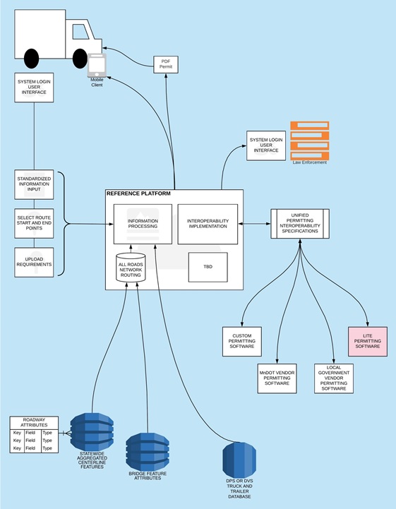
Phase II was a proof-of-concept pilot project spanning St. Louis County, Polk County, the City of Duluth, and MnDOT Districts 1 and 2. The goal was to see if a permitting platform would work across jurisdictions connecting various permitting software and using multiple system processes. “The platform has to be usable in different ways and be able to channel payment back to MnDOT or a county or city,” Sanders says. “Phase II showed UPP could work.”
Phase II also underscored the complexity of the issues to come. “The vision is for haulers to enter their license data, and the required permit data would automatically populate the permit,” says Mitch Rasmussen, assistant commissioner with MnDOT State Aid. “But all kinds of software systems are now in use by local agencies, and MnDOT’s Office of Freight and Commercial Vehicle Operation is preparing to replace the two online systems it’s been using for decades. All the systems will need to talk to the unified platform. It will take time and money to build. The roadmap from Phase II can help us get there.”
Policy and fee differences are another challenge. To gather context and ideas, MnDOT recently completed a Transportation Research Synthesis to explore the practices of other state transportation agencies in setting, collecting, and distributing permit fees for heavy commercial OSOW vehicles (see related article). Another MnDOT study is under way to gather basic data about the permit fee policies of counties in Minnesota and throughout the country, including authority for the fees, cost range, and fee types.
When Polk County switched from a paper system to an electronic one, industry started applying for permits more consistently, Sanders says. With the paper system, five or six permit applications would be faxed in each year, and approval could take two days. But with its online system, the county received 201 applications between January 1 and October 26, 2018. “Approval might take us 30 seconds,” he notes.
UPP work to date has been funded by MnDOT and the Minnesota Local Road Research Board. Others involved include the Federal Highway Administration, state agencies (Minnesota Department of Public Safety, Driver and Vehicle Services, Minnesota State Patrol, Minnesota IT Services Geospatial Information Office), associations (Minnesota Association of Townships, Minnesota County Engineers Association, Associated General Contractors of America), private businesses (ProWest, SRF Consulting, Midstate Reclamation & Trucking, Tiller Corporation), and educational institutions (Upper Great Plains Transportation Institute, NDSU; Alexandria Technical & Community College). UPP Phases I & II were a unique collaborative public-private partnership to resolve a long-standing problem.
Next phases and final outcome
Moving forward, Phase III will begin development of the unified system using real data from multiple road authorities and databases in MnDOT Districts 1 and 2. Phase IV will take the platform beyond Districts 1 and 2 and roll out the system for testing statewide. Estimated completion is two to three years.
“Under current plans for the unified system, Minnesota road authorities will continue to set their own fees and may be able to connect their existing software, although some interoperable adaptations will be needed,” Moe says. “The new permitting process will focus on education for haulers, permitting agencies, and the public, as well as engineering decisions by agencies. This, in turn, will lead to increased enforcement effectiveness to help preserve road quality while boosting the economy.”
“Many decisions are still on tap,” Rasmussen adds. “There’s no decision yet of who’s going to own it and manage it, for example, or what fees might be recommended. There are a million moving parts, and many agencies and interests are involved. But we’re taking big strides toward our central goal: putting the right load on the right road, the right way, right away.”
This article by Pam Snopl originally appeared in the December issue of the Minnesota LTAP Technology Exchange newsletter.
