Staff from MnROAD, the Minnesota Department of Transportation’s cold weather road research facility in Albertville, Minn., were presented with the Marlin J. Knutson Award for Technical Achievement by the American Concrete Pavement Association in December.
The award cites the facility’s well-deserved reputation for being a place where both agency and industry ideas are put to the test. This award was presented as a tribute to the agency’s commitment to learning and putting ideas into practice.
The Marlin J. Knutson Award for Technical Achievement is presented to an individual or group who has made significant contributions to advance the development and implementation of technical innovations and best practices in the design and construction of concrete pavements.
(Far right) Gerald Voigt, ACPA president and CEO, presented MnDOT with the Marlin J. Knutson Award for Technical Achievement. Receiving the award are (from left) Luke Johanneck, Bernard Izevbekhai, Roger Olson, Tom Burnham, Glenn Engstrom, Maureen Jensen and Sue Mulvihill. (Photo courtesy of the ACPA)
“MnROAD is helping to make roads last longer, perform better, cost less, construct faster, and have minimal impact on the environment,” said Gerald Voigt, ACPA president and CEO. “It is a model for other agencies to follow.”
MnROAD is a pavement test track initially constructed between 1991-1993. It uses various research materials and pavements and finds ways to make roads last longer, perform better, cost less to build and maintain, be built faster and have minimal impact on the environment. MnROAD consists of two unique road segments located next to Interstate 94.
Staff from the MnROAD facility in Albertville were recognized during the ACPA’s Distinguished Service and Recognition Awards ceremony in December. (Photo by David Gonzalez)
This article, authored by Rich Kemp, originally appeared in Newsline, MnDOT’s employee newsletter.
New streetcar lines are in the planning stages in Minneapolis and St. Paul. Proponents cite not only the lines’ ability to strengthen the transit system, but also their potential as catalysts for development. Estimating the impacts of streetcars is challenging, however, as most U.S. lines operate in downtown areas with many interrelated factors at play. A recent U of M research project examined the issue through the prism of one city’s experience: post-Katrina New Orleans.
The team—research fellow Andrew Guthrie and Assistant Professor Yingling Fan of the Humphrey School of Public Affairs—analyzed building permits near streetcar stops in the downtown business district and in several urban neighborhoods.
“Hurricane Katrina allowed—or required—more redevelopment to occur at a faster pace than normal, potentially allowing existing streetcar lines’ latent development impacts to appear,” Guthrie says. “This created an unfortunate yet rare opportunity for study.”
The researchers estimated how the frequency of commercial and residential permits changed with distance from streetcar stops, controlling for hurricane damage, proximity to existing commercial areas, and pre-Katrina demographics.
They found that throughout the system, building permits strongly reflect the distance to stops—and that commercial and residential permits move in opposite directions within the first 750 feet.
Commercial permits declined the further away the location was from a stop. In residential areas, commercial permits show variation depending on neighborhood characteristics. The number of neighborhood residential permits rose about 24 percent with every 100 feet from a stop.
Based on their results, Guthrie and Fan conclude that traditional streetcar lines can help increase commercial development not just in downtown business districts, but in other urban areas as well. The findings also indicate that streetcars shape development in urban neighborhoods in a fundamentally different fashion than light rail.
Read the full article in the January issue of Catalyst.
Although bike share systems are becoming more popular across the United States, little is known about how people make decisions when integrating these systems into their daily travel.
In a study funded by CTS, researchers from the U of M’s civil engineering department investigated how people use the Nice Ride bike share system in Minneapolis and St. Paul. The researchers examined how Nice Ride affects accessibility to jobs and developed a model to predict station choice.
In the first part of the study, the researchers created maps showing accessibility to jobs by census block for both Nice Ride and walking—as well as the difference between the two—at time thresholds ranging from 5 to 55 minutes.
Overall, in blocks with both Nice Ride and walking job accessibility, Nice Ride provides access to 0.5 to 3.21 times as many jobs as walking.
By comparing Nice Ride to walking, the study demonstrated that walking can successfully be used as a baseline to show how a bike share system improves job accessibility. The results also pinpointed when and where Nice Ride had the strongest accessibility advantage over walking.
“This type of information can be used by bike share system planners to identify where new stations could be built to maximize their impact on job accessibility,” says grad student Jessica Schoner, a member of the research team.
In addition, the team developed a theoretical model for bike share station choice. The model considers users’ choice of a station based on their preference for the amount of time spent walking, deviation from the shortest path (the closest station may not be in the direct path of the person’s destination), and station amenities and neighborhood characteristics.
Findings show that people generally prefer to use stations that don’t require long detours to reach, but a station’s surroundings also play an important role. Results also indicate that commuters value shorter trips and tend to choose stations that minimize overall travel time.
According to Schoner, understanding people’s station preference can help provide guidance to planners that want to expand or optimize a bike share system.
Read the full article in the January issue of Catalyst.
The Topeka shiner, a small minnow that inhabits slow-moving prairie streams, was once widespread and abundant in portions of Iowa, Kansas, Minnesota, Missouri, Nebraska and South Dakota. It now inhabits less than 10 percent of its original geographic range. (Photo courtesy of the Minnesota Department of Natural Resources)
In a new study funded by the Minnesota Department of Transportation, engineers are trying to ensure that new culverts do not degrade the habitat of an endangered fish in southern Minnesota.
The state has already researched how to better accommodate fish passage at river and stream crossings. Now it is looking at design guidelines for culverts that specifically impact the Topeka shiner, a small endangered fish found in five Midwestern states.
In Minnesota, the Topeka shiner is known to live in at least 57 streams, totaling 605 miles, within the Big Sioux and Rock River watersheds.
“The Topeka shiner is reported to have been erased from about 50 percent of its historic range in Iowa and much of its range in Minnesota, which is why Minnesota is so intent on doing what it can to help this fish thrive here,” said Alan Rindels, MnDOT’s project coordinator for the research.
The Topeka shiner is endangered due to the degradation of stream habitat, stream channelization, non-native predatory fishes and construction within waterways.
Culverts might impede the passage of this small minnow for a number of reasons, including that they might be too long, lack sufficient depth or carry water too fast.
Culverts (also called small bridges) allow water to pass under roads. Occasionally, they can harm a stream’s fish habitat by inadvertently acting as a barrier to fish passage or migration. On the West Coast, large-scale efforts are under way to protect migratory salmon, and in Minnesota, culvert designers are concerned about fresh water species.
In addition, long culverts block sunlight, which possibly discourages fish from swimming through. Typically, older culverts are replaced with longer culverts to improve road safety and minimize maintenance costs. To eliminate or minimize impacts to the Topeka shiner, the state is trying to determine if light mitigation strategies are necessary.
Researchers from the University of Minnesota’s St. Anthony Falls Research Laboratory will monitor a newly installed culvert (110 feet in length) and a few other culverts in critical Topeka shiner habitat streams during spawning and fall movement.
Additionally, a laboratory-based light manipulation experiment will examine the behavior of the warm-water fish when presented with a dark culvert.
Guidelines for culvert design in Topeka shiner habitat will be developed based on these results, as well as examples from neighboring states. The state is also collaborating with the U.S. Fish and Wildlife Service and affected Minnesota counties.
Minnesotans have grown accustomed to roundabouts as they’ve proliferated throughout the state, but many motorists are still confused by the less common two-lane roundabout.
While roundabouts have been shown to reduce vehicle delay and severe crashes, the few Minnesota cities with this type of multi-lane roundabout have had a prevalence of driver mistakes.
In Woodbury, two such roundabouts were converted into smaller, one-circulating-lane designs due to driver confusion.
The City of Richfield had no such option at the high-volume Portland Avenue and 66th Street, a formerly signalized intersection that carries about 30,000 vehicles per day. (See video)
Crash-prone and congested prior to its reconstruction in 2008, a two-lane roundabout seemed to be the practical solution for this intersection. But although the roundabout reduced overall crashes, the intersection still had more fender benders than designers were comfortable with, according to City Engineer Kristin Asher.
“The crashes were primarily related to improper left-turns from the outside lane and failure to yield at the entry,” she said.
Not only were drivers unsure which lanes they should use to enter or exit the roundabout, they didn’t know how to respond to other cars inside the roundabout. (See news story)
“People don’t understand they have to yield to both lanes inside the roundabout,” explained University of Minnesota researcher John Hourdos.
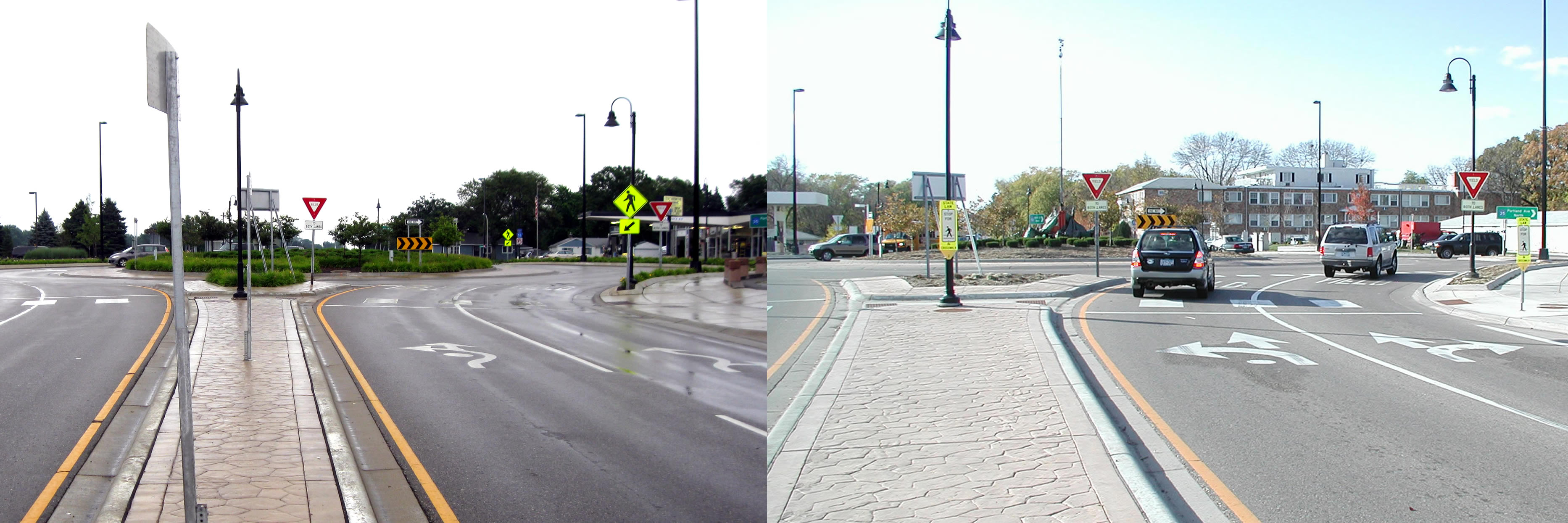
The city of Richfield extended the solid lines leading up to the intersection from 50 to 250 feet to encourage drivers to choose the correct lane before entering the roundabout. It also replaced fish-hook-style roundabout signs with traditional lane designation signs and did away with complex striping patterns.
Before and after photos show the original fish-hook style pavement markings, left, that were replaced with a more traditional design. (Courtesy City of Richfield)
Hourdos examined two years of traffic data to see how motorists responded to the improvements that were made in 2011.
He found 50 percent more drivers entered the correct lane from the get-go, which led to a reduction in improper turns within the roundabout. Lane violations were also reduced by 20 percent.
“One of the main problems was drivers didn’t know they have to choose one of the two lanes,” Hourdos explained. “Then once they were inside the roundabout, they were forced to either deviate from their course or commit a violation.”
The city also increased sign visibility to address yielding problems; however, these changes didn’t seem to make a difference.
With state and federal guidelines lacking much guidance for how to sign two-lane roundabouts, the LRRB is funding a new study for three other multi-lane roundabouts: in St. Cloud, at Highway 169/494 and one planned for the future realignment of County Roads 101 and 61 between Chanhassen and Shakopee.
Manual field counts require more labor than automatic technologies, but they can collect deeper data about demographics and helmet use. Both forms of monitoring are necessary to give a complete picture of bicycle and pedestrian traffic in the state.
To prepare for a multimodal future, state agencies must be able to plan and engineer a transportation system for all modes of transportation, including bicycle and pedestrian traffic.
The Minnesota Bicycle and Pedestrian Counting Initiative was launched to develop consistent methods for monitoring non-motorized traffic across the state. Researchers developed guidelines for manual counts using state and national examples, and they also created methods for extrapolating annual traffic volumes from short-duration automated counts, for integration into MnDOT’s vehicular count database program.
The guidance developed for manual counts includes forms, training materials, public information for passers-by, links to smartphone applications that provide counting locations and spreadsheets for reporting results.
MnDOT hosted six workshops and a webinar to introduce local officials to the initiative and recruit participants for pilot field counts. Researchers then analyzed how these field counts could be used with existing automated counts to extrapolate daily or annual data.
MnDOT has installed some of the very first automated counting equipment on a state road — Central Avenue NE in Minneapolis (on the bike lane) and Highway 13 in Eagan (on a shoulder). As of 2012, six agencies in Minnesota counted non-motorized traffic (annual reports are available from the city of Minneapolis and Transit for Livable Communities), and even though comprehensive data is not yet available, Minnesota is a leader in this type of monitoring with more than 1,000 manual count locations and 32 automatic count sites.
Because of Minnesota’s experience, researchers collaborated with the National Cooperative Highway Research Program’s national Methodologies and Technologies for Collecting Pedestrian and Bicycle Volume Data research project, due for release in 2014, and contributed to the Federal Highway Administration’s effort to update its Traffic Monitoring Guide to include a chapter on non-motorized traffic.
It’s no secret that manufacturing plays a key role in driving economic growth, or that transportation is essential for the success of any manufacturing operation.
While the relationships among manufacturing, transportation, and economic growth have been studied on a large scale, there is often little dialogue between transportation organizations and the manufacturers themselves. A recently completed pilot study conducted jointly by the Minnesota Department of Transportation (MnDOT), the University of Minnesota Humphrey School of Public Affairs, and University of Minnesota Extension aims to address this communication gap.
The pilot project focused on 12 counties in southwest Minnesota, where more than 172 regional businesses were contacted for participation and 75 in-person interviews were completed with manufacturers, shippers, and carriers. During the interviews, participants were encouraged to focus their comments on high-value, low-cost improvements that MnDOT can address in the short term without over-promising projects that currently cannot be funded.
Participants identified the need for smooth pavements and wide shoulders, the value of advance warning lights at intersections with traffic signals, the importance of highway safety, and the challenges of maneuvering oversized vehicles through roundabouts, among others.
The research team is compiling the pilot study’s findings into a final report. In the meantime, MnDOT is working to address a number of the challenges and suggestions uncovered through the pilot program.
Read the full article in the December issue of Catalyst.
This video above showcases a new kind of intersection conflict warning system being developed for use primarily by local agencies at rural, two-way stop intersections. Called the ALERT System, it uses a simple but ingenious combination of radar, wireless communication and flashing LEDs to alert drivers to the presence of approaching vehicles, thereby helping them identify safe gaps in the cross traffic and avoid potentially deadly collisions.
These types of systems are nothing new; MnDOT and other state DOTs have been developing them for more than a decade under the ENTERPRISE pooled fund program. MnDOT also recently kicked off a three-year project to deploy 20–50 of its Rural Intersection Conflict Warning Systems at selected at-risk intersections across the state. The main difference with the ALERT System is that it’s designed to be cheaper and easier to deploy than existing ICWS technologies. While that might sound like an incremental improvement, the difference for cash-strapped local agencies could be huge.
Since the ALERT System uses solar power, it doesn’t have to be hooked up to the power grid — which means that, in theory, county public works crews could install it themselves. The system also uses a simplified controller that doesn’t require a traffic signal technician to install and maintain, and detects vehicles using radar rather than in-pavement sensors. These factors might encourage greater adoption of ICWS technologies, which studies have shown to reduce both the frequency and severity of crashes.
The project is now in its second phase. It still faces a number of hurdles before could be ready to deploy, but Vic Lund, the traffic engineer for St. Louis County and the project’s main champion, says the results so far have been encouraging. In the video below, Lund shares his thoughts on the project, its challenges and the future of Intelligent Transportation Systems in Minnesota.