The longest winter in recent memory might have ended, but MnDOT’s traffic and maintenance staff are already planning how to make future winters easier on Minnesota drivers.
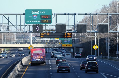
Recently, the Regional Transportation Management Center was awarded funding to deliver real-time winter weather warnings via its roadside and overhead highway message signs. The RTMC displayed blizzard warnings for the first time during six storms last winter, but the alerts had to be manually entered.
“This is similar information that you receive on your cell phone or the evening news,” said Brian Kary, RTMC Traffic Operations director. “But for somebody who’s traveling down I-90 and just passing through, they might not realize that they’re entering an area with a blizzard.”
Another initiative aims to expand the road condition data that’s available during winter storms by piloting the use of mobile sensors on maintenance supervisor trucks and above-ground sensors at select Road and Weather Information System sites.
Both projects are among eight research implementation projects recently selected for funding by the governing board for MnDOT’s transportation research program.
Weather Alerts
Minnesota has nearly 300 Dynamic Message Signs, which currently issue real-time warnings about traffic incidents, road work and congestion. Around 200 are in the Twin Cities metro; the rest are in Greater Minnesota.
Kary’s two-year project will develop a system that can automatically relay critical weather alerts, which change frequently, are labor-intensive and error-prone when physically entered. Only blizzard warnings from the National Weather Service are initially planned, but the system will be capable of broadcasting all types of weather alerts.
A number of other states already issue weather alerts via their Dynamic Message Signs, so MnDOT has case studies to look at.
Over the next two years, the Maintenance Office will test the use of mobile and above-ground sensors to expand the geographic coverage of RWIS sites, which feed valuable weather and road surface information to highway operations managers and advanced traveler information systems. This might lead to the elimination of in-road sensors, which require lane closures to maintain and must be replaced during road construction projects.
The mobile sensors will collect road condition information, such as temperature, humidity, due point, and friction, from five maintenance supervisor trucks. The other non-invasive sensors will be attached to an RWIS tower or a pole near the roadway and use laser technology to read road surface temperature and condition (water ice, slush and snow).
Potholes are one of the biggest and most costly ongoing maintenance challenges faced by highway agencies. Despite considerable progress in pavement materials and mechanics, pothole repair has remained an area in which little progress has been made.
To make headway in this area, Minnesota transportation researchers studied critical factors in pothole formation and repair in order to identify solutions that would reduce the occurrence of potholes and increase the durability of repairs. They also investigated the potential of newer materials, such as taconite and graphite nanoplatelets (GNP), in repair mixes. Researchers looked at how to make winter patches more durable and also different shapes of patches.
“Our goal was to provide a scientific assessment of pothole repair materials and practices,” said University of Minnesota professor Mihai Marasteanu, the lead researcher. Project sponsors were the Minnesota Department of Transportation (MnDOT) and the Minnesota Local Road Research Board.
What Did We Do?
Researchers began by reviewing national and international literature about pothole causes and repair activities. They also surveyed MnDOT maintenance superintendents and local engineers on current repair practices.
Next, the research team conducted simulations of square, diamond, and round pothole repair shapes to determine if some shapes were more conducive to reducing stress in repair materials. This stress analysis included the use of different common pothole filling mixes and their interface with existing pavement materials.
In the next stage of research, the team evaluated six asphalt mixes for relevant mechanical properties: four winter mixes, a polymer-modified hot-mastic asphalt mix suitable for winter and summer use, and a summer mix in two forms modified with GNP. Mixes were evaluated for compaction and bonding, tensile strength, and water penetration.
Pothole repair samples performed poorly in water penetration tests, which suggested that most mixes will perform poorly under seasonal freeze-thaw stresses.
Finally, researchers studied national and international pavement preservation and pothole prevention practices and the cost-effectiveness of pothole repair.
What Did We Learn?
Through this work, researchers learned that pothole prevention requires repairing pavement cracks as they develop—and sometimes, even timely repairs only slow pothole development.
Laboratory analysis showed that cold mixes compact and bond poorly. To be more effective, these materials require significant curing not possible in the field unless heating is provided. The polymer-modified mastic patching material that was heated was stronger than the winter mixes even at very cold temperatures. Most mastics are used in warm weather, but this material may be effective for winter uses.
Durable winter repairs require expensive patching materials and on-site heating technologies such as truck-mounted microwaves. “To make winter repairs last longer, you need to provide an external source of heat to cure winter patching materials,” Marasteanu says.
Taconite-based materials activated chemically or by heating potholes before and after filling offer promise for more durable repairs. GNP modifiers improved compaction, tensile strength, fracture energy, and fracture resistance in the summer mix.
Pothole repair samples performed poorly in water penetration tests, which suggests that most mixes will perform poorly under seasonal freeze-thaw stresses.
Also of note, the study’s exploration of pothole repair shapes found that circular repairs offer the best filling and compacting performance; repair materials cannot fill corners, even with significant compaction.
“We had been squaring off potholes, making sure patches were all at right angles. But in this study, we found that square patches increase stresses at the boundaries. The ideal is a circular patch,” said Todd Howard, Assistant County Engineer, Dakota County.
What’s Next?
The most common pothole repair in Minnesota is throw-and-roll with HMA (using a truck’s tires to compact shoveled-in asphalt). Newer, more durable repairs include taconite-based materials activated chemically or by heating potholes with a truck-
mounted microwave unit before and after filling. While promising and, in the case of the microwave method, potentially effective in extreme cold, these approaches require further research before becoming widely used in winter and spring repairs.
GNP-modified mixes also warrant further study, especially in winter mixes. If MnDOT can encourage cost tracking, analysis of the cost-effectiveness of various pothole repair methods, including the mastic tested in this research, may become possible.
This research is part of a larger effort by MnDOT to improve pothole repair approaches and develop pothole repair guidance for crews throughout the state, including a recently released asphalt patching best practices guide with decision trees.
The accumulation of chloride in our waters has become a widespread concern. In a recent study sponsored by MnDOT and the Local Road Research Board, researchers measured the transport and accumulation of chloride from road deicers in a metro-area watershed. The findings revealed a greater infiltration of chlorides into soil and subsurface waters than previously assumed.
“The results of this research provide us with knowledge we did not
have before,” says William Herb,a research associate with the University of Minnesota’s St. Anthony Falls Laboratory and the study’s principal investigator. “It will help investigators and policymakers explore ways to capture chlorides and mitigate their damaging environmental effects.”
Road salt (sodium chloride) is used in most states that experience snow and ice, with growing impact. For example, chloride levels in some lakes and streams in the Minneapolis–Saint Paul metro area exceed state and federal water quality
standards, and a recent study showed that levels in more than one-quarter of shallow groundwater wells in the metro were above drinking-water taste standards.
“This is a real concern because even in low concentrations, chloride can be lethal to sensitive plants and some aquatic species, and many of our lakes, wetlands, and streams show acute or chronic levels of chloride,” Herb says.
To learn how chlorides from road salt deicers are transported in urban watersheds, researchers installed field instruments at eight sites in a Roseville watershed. They monitored water and chloride levels nearly continuously over three winter seasons; this included runoff directly from sources (roads and parking lots), transport in ditches and sewer networks, and retention in and release from detention ponds and wetlands. Computer modeling was used to generalize results.
This drain along State Highway 36 was one of the roadway runoff discharge sources used in the study.
Overall, the team observed substantial chloride retention via infiltration to soils and groundwater. For example, monitoring the runoff from a vegetated highway ditch showed that more than 95 percent of the chloride applied to the highway infiltrated
from the ditch into the soil, and less than 5 percent was exported from the site in surface runoff. “Interestingly, substantial chloride export from the ditch was observed in November rainfall runoff prior to application of any new road salt for the upcoming winter, suggesting long-term storage in soils and groundwater in and near the ditch,” Herb says.
Researchers also found that winter rain-on-snow events and the first major
prolonged thaw each season moved surface chlorides most effectively into the watershed.
The research team then used the data and modeling to examine potential strategies for reducing or mitigating the spread of chloride, including capturing low flows, seasonal runoff capture, and capture based on salinity.
Wayne Sandberg, deputy director of the Washington County Department of Public Works, chaired the study’s technical advisory panel. “Based on this research, we now know that deicer chemicals are staying in the soil and moving in the watersheds, and this should change how we manage ice and snow control,” he says. “The next questions are what can we do with that knowledge and what changes can we make.”
MnDOT installed network dash cameras and ceiling-mounted cameras on 226 snowplows, approximately one-quarter of MnDOT’s snowplow fleet. The cameras, integrated with the onboard mobile data computer and automated vehicle location equipment, automatically captured snapshots of road conditions during plowing. The snapshots were incorporated into several facets of MnDOT’s 511 traveler information system: the desktop and mobile versions of the website and the 511 app. Motorists and MnDOT alike found the project to be valuable, with the up-to-the-minute imagery helping members of the public and MnDOT’s maintenance staff make well-informed decisions during winter storm events.
“The largest barrier to implementation involved the development of the software package for integrating snowplow cameras into the current AVL system. It required a great deal of back-and-forth to get things right,” said oe Huneke, Maintenance Decision Support Systems (MDSS)/AVL Section Manager, MnDOT Office of Maintenance.
“We did research to make sure the cameras did not block drivers’ views, taking state and federal regulations into consideration, and we tested the cameras to make sure they were capturing images at the right resolution,” said Jon Bjorkquist, Maintenance Technology Development/ Implementation Coordinator, MnDOT Office of Maintenance.
What Was the Need?
Reliable information about road conditions during winter weather allows motorists to make informed travel decisions and helps MnDOT responders maintain roads. While meteorological updates on a winter storm and automated status reports on Minnesota’s snowplow fleet are important sources of data, they do not provide visual information about road conditions.
In 2015, a pilot project allowed MnDOT to take road condition pictures from cameras mounted on selected snowplows during winter storms. The system was limited, however. Few snowplows were outfitted with these cam-eras, images were not available to the public, and network infrastructure did not allow for easy scaling. A larger scale program was needed to capture road imagery taken from snowplows across Minnesota and to share the pictures with Minnesota motorists.
What Was Our Goal?
MnDOT sought to install cameras on a sizable portion of MnDOT’s snowplow fleet. In addition to making hardware and network enhancements to collect and compile the image data, MnDOT also set out to make the photos avail-able in near-real-time to its internal maintenance staff and the traveling public.
To capture images of road conditions, MnDOT mounted cameras in the cabs of one-quarter of MnDOT’s snowplow fleet.
What Did We Do?
In 2015 and 2016, MnDOT installed network dash cameras and ceiling-mounted cameras on 226 snowplows, approximately one-quarter of the agency’s total snowplow fleet. The cameras, integrated with the onboard mobile data computer and automated vehicle location (AVL) equipment, automatically captured snapshots of road conditions during plowing. This system included the following key operational features:
The dash cameras automatically recorded images whenever the computer-AVL system was on.
The cameras recorded an image of the road ahead of the plow.
Images were taken once every five minutes and were only retained if the plow was moving at least 10 mph.
The cameras were capable of taking operator-initiated snapshots and video clips.
Video clips could be classified into three categories: accident, general interest or work zone.
The system sent the plow camera images and metadata (geolocation, plow, camera and conditions) to a MnDOT server upgraded to accommodate the data. MnDOT set a data retention schedule for mobile snapshots and video segments as well as the data server.
Plow images were incorporated into several facets of MnDOT’s 511 traveler information system, including the desktop and mobile versions of the website and the 511 app. Plow images plotted at 10-minute intervals on the 511 maps provided motorists with up-to-the-minute, easily accessible information on road conditions. The images were also incorporated into MnDOT’s internal website called Condition Acquisition and Reporting System.
What Did We Learn?
The project demonstrated the successful integration of various hardware, software and network systems, carrying the road weather imagery step by step from the cameras to the public 511 interface. The project also succeeded in scaling up an earlier, modest effort to furnish snowplows with cameras.
In addition, MnDOT collected input on the value of the cameras from a range of interested parties: the public, snowplow operators and supervisors, and MnDOT management staff.
The public response was overwhelmingly positive, with 319 Facebook users responding to a MnDOT post about the cameras. All the respondents used positive emote icons (“heart” or “thumbs up”). Several members of the public provided responses through Facebook and MnDOT’s “Contact Us” Web page about the value of being able to view actual road conditions, though others expressed concern about the cost of the system.
Surveys of MnDOT snowplow drivers and supervisors and interviews of MnDOT managers revealed that supervisors and managers had a largely positive view of the program as well. Drivers provided mixed reviews. Comments from these groups yielded the following recommendations about implementing a program of this nature:
Perform outreach efforts that clearly communicate benefits to achieve broad buy-in from snowplow drivers. Provide training and follow-up instruction on use of the cam-era’s features to encourage drivers to use the manual snapshot and video features.
Address drivers’ concerns about privacy (such as “Big Brother is watching”) directly, and understand that these concerns have lessened over time. Supervisors should be advised not to react too quickly to privacy concerns.
Address concerns about in-cab distraction by adjusting the system configuration or hardware. This might include making dash camera screens dimmable at the driver’s option, or placing screens and cameras out of critical sightlines.
What’s Next?
This project was a success, with snowplow camera images providing significant benefits to MnDOT staff and the traveling public. Based on this work, MnDOT plans to install camera systems on additional snowplows in the state fleet—as deemed necessary by district management—and to continue displaying snowplow images on MnDOT’s 511 system.
For most road crews, repairing potholes is an essential and highly visible duty. Choosing the best or most cost-effective pothole repair method, however, has remained a complicated puzzle.
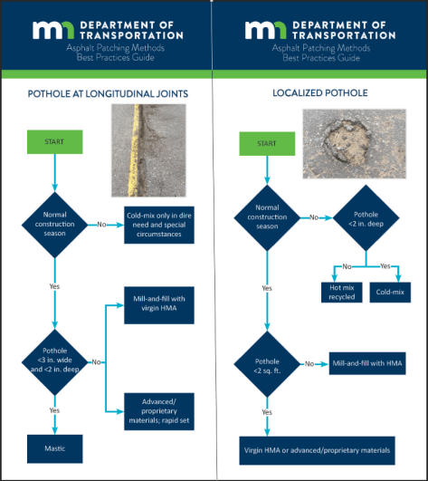
Researchers identified four pothole repair methods suitable for Minnesota: cold mix, hot recycled asphalt, mastic material and mill-and-fill with hot-mix asphalt. They tracked the performance of each method at five sites in northern Minnesota for two years. Using the results from this monitoring period, researchers developed decision trees for selecting an appropriate repair method and best practices for using each method. The decision trees were developed in two formats: as a flowchart that can be used in a maintenance guide and as flash cards that can be laminated and used by maintenance crews for quick reference in the field.
“We wanted to develop a decision tree for choosing the right pothole repair method that could be laminated for use in the field,” said Susan Lodahl, Assistant State Maintenance Engineer, MnDOT Office of Maintenance.
“This project offers help deciding what kind of pothole patch is appropriate for the conditions, including the pothole dimensions, location in the roadway and the season,” said Manik Barman, Assistant Professor, University of Minnesota Duluth Department of Civil Engineering.
What Was the Need?
Repairing potholes is one of the most public of road crews’ duties. Drivers notice cracks and holes, and feel the effects of short-term repairs that kick up gravel as wheels roll over patched holes.
Selecting the appropriate patching method and materials varies depending on several factors, including the size of the pothole and its location on the roadway. Patching methods and materials face seasonal challenges too. In northern Minnesota, asphalt plants shut down for the winter and don’t reopen before March, if then. Potholes that are repaired in cold weather aim for short-term fixes with patches that can be replaced when warm weather returns or when the pavement can be milled and overlaid with hot-mix asphalt (HMA). Road crews have tried applying HMA in winter using various heating systems and in-place recycling methods, but even warm weather patches only offer semipermanent repair.
Whether it’s spring, summer, fall or winter, choosing the best, most cost-effective or durable pothole repair method has remained a complicated puzzle, one that MnDOT would like to help road crews solve.
What Was Our Goal?
MnDOT funded this research to help road crews choose patching methods that match specific repair conditions. Researchers explored patching tools, materials and methods to identify those most appropriate to specific pothole conditions, road locations and time of year. They also evaluated the effectiveness of different methods based on durability, road safety, ride quality, driver satisfaction and other factors.
A researcher conducts an on-site permeability test to determine how well a pothole repair seals and resists water penetration.
What Did We Do?
Research began with a comprehensive literature search of pothole repair methods in Minnesota and other states. From this search, investigators identified four repair methods that best suit Minnesota: cold mix, hot recycled asphalt, mastic material and mill-and-fill with HMA.
With help from the study’s Technical Advisory Panel, researchers identified five sites in MnDOT District 1 near Duluth, Minnesota, where they oversaw 20 pothole repairs. Investigators monitored these repairs for about two years before assessing the methods and their best applications. Researchers then developed decision trees to help road crews choose the most suitable method for each repair and compiled best practices to provide further guidance.
What Did We Learn?
The best practices describe the best uses of each of the four pothole repair methods along with guidelines for preparing the pothole for repair and placing the patching materials.
Cold-mix patches should be placed only in shallow potholes with depths of 2 inches or less. Deeper potholes should be repaired in two lifts, each compacted with a handheld compactor to prevent dishing or denting when the cold mix settles.
Hot mixes using recycled materials should be avoided. The aged binder slows the heating process, and its fines inhibit the bonding of the new binder and aggregate. The new binder also doesn’t seem to rejuvenate the old, and the patches age more rapidly. When hot mix is used for pothole repair, a handheld compactor is required. Recycling mixers such as the Stepp SRM 10-120 should be used to create virgin hot patch material using asphalt oil and sand or small aggregate.
Mastic material provides a smooth driving surface but appears to dish in potholes along longitudinal cracks because the material lacks the strength to support loads. Mastic should only be used on centerline joints and longitudinal joints along shoulders, where it stays in place. It should not be used in wheel paths.
Mill-and-fill with virgin HMA, when constructed with care, can be effective in eliminating dishing and raveling at the patch-pavement interface. Sufficient tack material must be used, and trucks should not be allowed to drive on the tack. The pothole should be filled with the proper amount of HMA, and the patch must be compacted sufficiently. Failure to carefully apply mill-and-fill can lead to significant deterioration at the patch-pavement interface after about 100 days, which can contribute to additional damage in the distressed area.
Using the findings from this study, researchers developed guidelines for patching method selection, placement, compaction practices and moisture control. They also developed decision trees for selecting the appropriate repair method for conditions. The decision trees are available in two formats: as a flowchart for use in maintenance guides and as flash cards for quick reference by maintenance crews in the field. The final report includes best practices and a step-by-step pictorial guide to patching.
What’s Next?
The decision trees and best practices developed in this study can be easily combined into a patching guide that, with laminated flash cards, can be distributed to MnDOT road crews around the state. This research could be amplified by repeating the process with more pothole repairs in other areas of Minnesota to increase data for performance evaluation and analysis of best practices.
Keeping Minnesota’s roadsides green is about more than just aesthetics—healthy turfgrass can improve water quality, reduce erosion and road noise, and provide animal habitat. However, harsh conditions such as heat, drought, and salt use can make it difficult for roadside turfgrass to thrive.
In 2014, as part of a study funded by the Minnesota Local Road Research Board (LRRB), researchers in the University of Minnesota’s Department of Horticultural Science identified a new salt-tolerant turfgrass mixture that could be used on Minnesota roadsides. But, when MnDOT began using the mixture, called MNST-12, the agency experienced a series of installation failures.
Now, led by Professor Eric Watkins, the research team has identified new best management practices for installing and establishing this type of salt-tolerant turfgrass. The study, funded by the LRRB, specifically focused on watering practices, soil amendments, and planting date for both seed and sod.
“Newer improved seed or sod mixes like MNST-12 may have differing requirements for successful establishment compared to other species or cultivars that contractors and other turf professionals are more familiar with,” Watkins says. “Since all of these management practices are prescribed—or not prescribed—in the MnDOT specifications, generating data that can inform future specifications is a valuable outcome of this work.”
The study, which was conducted over several years, included experiments on how water should be applied to new MNST-12 turfgrass installations, the use of soil amendments at the time of establishment, and the effect of the seeding or sodding date on the success of a new planting.
Researchers tested turfgrass watering requirements using an automated rain-out shelter. Photo: Matt Cavanaugh
Based on their findings, the researchers recommend these changes to MnDOT specifications:
No soil amendments are necessary, but adequate seedbed preparation is important.
Seeding is preferred to sodding between August 15 and September 15.
Sodding can be permitted throughout the year, but only if the installer is able to supply frequent irrigation.
When watering in sod, attention should be given to the species being used and local rates of evapotranspiration (evaporation from both the soil and plant leaves). Sod installers can anticipate using between 100,000 and 170,000 gallons of water per acre to ensure a successful establishment.
Sod can be mowed as soon as sufficient root growth prevents an operator from manually pulling up pieces by hand, but it should not be mowed if wilting from heat or drought.
Currently, the researchers are using the results of this project to develop methods for educating and training stakeholders, including turfgrass installers, on these best management practices. They are also developing systems that could be used by installers in the field to help maximize the success rate of turfgrass installations.
“These best management practices can help limit installation failures and reduce maintenance inputs for future installations, providing both an economic and environmental benefit,” Watkins says.
“The knowledge and improved specifications we gained through this research will allow us to make our contractors more successful, which makes MnDOT successful,” says Dwayne Stenlund, MnDOT erosion control specialist. Because local agencies often rely on these MnDOT specifications as a guide for their projects, they will also benefit from the improved practices.
Stenlund also says the new specifications—especially those related to watering requirements—could allow for a clearer understanding of the true cost and value of turfgrass installation and maintenance work, which could ultimately improve the accuracy of the project bidding process.
In another project, the research team is exploring other turfgrass stresses, such as ice cover and heat. They are also testing additional turfgrass species and mixtures in an effort to continue improving MnDOT specifications for roadside turfgrass installations.
A pilot project was begun to study the use of AVL technology in mowing operations. Potential benefits include improved mowing efficiency, improved reporting and ease of supervision, reduced paperwork and reduced spread of noxious weeds.
“Using the data we get from the AVL project, we can estimate how long it will take to mow the entire system,” said Douglas Maki, Asset Management Engineer, MnDOT Metro District. “That way, we can plan far in advance of major holidays, when the most traffic comes through our system.”
“The AVL technology can be used to mark newly disruptive weed locations and anything else a mower operator might see, like potholes, damaged signs or guardrails, and excessive or dangerous debris in the field,” said Adrian Potter, Senior Associate, SRF Consulting Group, Inc.
Potter served as the project’s principal investigator.
What Was the Need?
MnDOT is responsible for mowing roadsides along 14,000 centerline miles of highways for environmental and safety reasons. This is an enormous and critical task, requiring efficient use of employee time and mowing equipment, and efforts to avoid the spreading of noxious weeds, which will lead to increased use of herbicides.
A promising technology that many departments of transportation (DOTs) have installed is automated vehicle location (AVL). AVL systems provide a precise geographic location for DOT-owned vehicles so that real-time data can be obtained on field operations. This technology has been used for snowplowing and other fleet vehicle operations. However, only a few DOTs have used it for mowing operations.
To determine if AVL technology should be used in its
mowing operations, MnDOT undertook a pilot project involving 30 of its mowers. The locations chosen were Metro District roadsides, as MnDOT had previously invested in creating a geographic information system map of noxious weeds on those roadsides.
What Was Our Goal?
The goals of the pilot project were to:
Generate protocols for hardware installation and software training.
Set up the system for communicating data from the mowers to internal MnDOT servers.
Develop accomplishment reports based on data collected by the AVL units.
Develop and provide initial training to operators and supervisors.
Optimize the mower routes used.
What Did We Do?
For the 2015 and 2016 mowing seasons, researchers fitted 30 Metro District tractors with AVL technology, sensors and communication equipment.
The first stage of the project focused on developing the software interface required for the AVL system. The application had to provide a view of the mower’s exact location so that the mower operator could avoid noxious weeds. Data would be collected through an in-vehicle controller unit and transferred to MnDOT for analysis via a Verizon AirCard system installed on each mower.
Mechanics installed metal racks within each of the 30 mowers to protect the Ameritrak AT-500 AVL hardware unit. A video screen was mounted on the top of the rack. A reporting system was developed for use by operators, supervisors and managers. Training sessions were scheduled at the start of each season and when new operators were hired.
What Did We Learn?
The project achieved its initial goals of developing protocols for hardware and software, creating electronic reporting and capturing real-time data.
The research team gained the following insights during the planning and field-testing stages of the project:
Substantial time is needed to adequately develop and test the AVL software and hardware.
Implementing the system also requires considerable time due to resource limitations, and after implementation, it takes multiple mowing seasons to quantify weed and herbicide reductions.
MnDOT mower operators and supervisors recognized the value of the AVL system in improving the efficient use of their time, eliminating the drafting of written reports, and giving MnDOT a more accurate record of acreage mowed.
Since the tractors operated at such slow speeds, the initial data captured were too imprecise to analyze. But with software adjustments, this issue was resolved.
Installation of the AVL unit could have an impact on the operation of the tractor because the additional electrical burden that the unit places on the tractor battery may require the tractor to be sent to the manufacturer for inspection.
What’s Next?
The initial success of the pilot project provided the basis for continued use of AVL technology in Metro District mowing operations during the 2017 season and possibly beyond. MnDOT is currently evaluating whether this project has provided enough data to expand AVL to other districts in the state. The investigators estimate that after full implementation, MnDOT could save $100,000 per year.
MnDOT may consider installing AVL technology in other agency equipment to optimize and monitor maintenance activities.
When drivers approach a roadway work zone at high speeds, they put the lives of work-zone flaggers at risk. To keep flaggers safe on the job, U of M researchers are looking for better ways to capture drivers’ attention—and compel them to slow down—as they approach flagger-controlled work zones.
Kathleen Harder, director of the Center for Design in Health, and John Hourdos, director of the Minnesota Traffic Observatory, identified and tested new work-zone warning elements to more effectively capture and sustain driver attention. The project was funded by MnDOT and the Minnesota Local Road Research Board.
The project began with a simulator study in which participants completed three drives, each featuring a work zone with different warning treatments. One condition was a traditional four-sign configuration currently used to warn drivers approaching work zones. The other two conditions featured a variety of new elements, including signage with new messaging such as a “one-lane road ahead” sign with flashing LED lights, a dynamic speed warning sign equipped with a loud warning horn that sounded if drivers exceeded the speed limit, and portable rumble strips.
“Overall, we found that the new set of elements is more effective than the elements currently used to reduce driving speeds on the approach to a flagger-controlled work zone,” Harder says.
Although adding LED lights to the one-lane road sign had no significant effect on drivers’ speeds, findings indicated that the dynamic speed sign coupled with the horn was more effective than the dynamic sign alone.
To test these new elements under real-world conditions, the researchers conducted field tests evaluating two configurations in Minnesota work zones. The first configuration followed the minimum standards outlined in the Minnesota Manual on Uniform Traffic Control Devices. The second deployed signs employing new messaging and attention-getting devices, including a dynamic speed warning sign, horn, and rumble strips.
Findings showed that the combination of the dynamic speed warning sign and the horn successfully reduced the overall speed of vehicles approaching the work zone. The portable rumble strips did not cause any significant speed reduction, but this may have been related to their location downstream from the dynamic speed sign and horn.
“Our findings reveal that the new set of elements designed to capture driver attention—including new messaging, a dynamic speed trailer, and horn—had a significant influence on reducing driver speed,” Harder says. “The experimental layout practically eliminated high-speed outliers and successfully reduced the approach speed to the flag operator.”
Winter weather events have a regional and often national impact. “Storms never stop at the state line,” said Tom Peters, research and training engineer, MnDOT Maintenance Operations. “That’s why it’s so important for us to know about winter maintenance efforts around the country, and particularly at neighboring states with similar climates.”
MnDOT leads the Clear Roads Transportation Pooled Fund Project (clearroads.org), a national winter maintenance research consortium. In 2015, Clear Roads launched a national survey to collect and report the annual winter maintenance operations of state DOTs. The effort included nearly 50 data points related to equipment, materials and costs.
The results, which are available at clearroads.org/winter-maintenance-survey as a Microsoft Excel-based spreadsheet, are available at no cost for users to examine, analyze and parse as needed. Beyond the raw data, the spreadsheet includes calculated statistics and an interactive map for plotting key metrics.
The results quantified much of what was known only anecdotally and provided useful, actionable data. “Data trends by geographic region and over time let us make more informed operations decisions,” Peters said. “We can also draw on this information to communicate with management, elected officials and the public about how MnDOT’s winter operations fit in a national context.”
As the lead state, MnDOT commits significant administrative time and attention across the agency to Clear Roads. “It’s rewarding and satisfying to see such a useful product as one of the payoffs for all this effort,” Peters said.
Additional data collection for the 2015-2016 winter season is already complete. Look for an update to the online database later this year.
Research in Progress
Clear Roads has nearly a dozen research projects in progress, including:
At its September meeting in Omaha, Nebraska, the Clear Roads Technical Advisory Committee funded five new projects:
Utilization of GPS/AVL Technology: Case Studies
Standards and Guidance for Using Sensor Technology to Assess Winter Road Conditions
Emergency Operations Methodology for Extreme Winter Storm Events
Weather Event Reconstruction and Analysis Tool
Training Video for the Implementation of Liquid-Only Plow Routes
What is Clear Roads?
Clear Roads is a 33-member pooled fund program dedicated to winter road maintenance research. Led by MnDOT, Clear Roads projects evaluate winter maintenance materials, equipment and methods; develop specifications and recommendations; study and promote innovative techniques and technologies; and develop field guides and training curricula. Learn more at clearroads.org.
As the first big snow and ice storms sweep through parts of Minnesota today, we’d like to remind you of some of our great winter weather research studies. Here’s a list of some of this winter-related research from MnDOT and the Local Road Research Board:
Living snow fences
Living snow fences are trees, shrubs, native grasses, wildflowers, or rows of corn crops located along roads or around communities and farmsteads. These living barriers trap snow as it blows across fields, piling it up before it reaches a road, waterway, farmstead or community. Through multiple research efforts, MnDOT continues to advance its practices for living snow fences. Willow plants, which are which are inexpensive and fast-growing, are a new form of snow fence. MnDOT has also developed a tool that allows the agency to better offer a competitive payment to farmers.
According to recent studies, researchers believe Minnesota could eliminate salt usage on low-volume local roads by switching to permeable pavements. Permeable pavements — pavements that allow water to seep through them — have been studied in some Minnesota cities, and a research project is currently underway to further investigate how much salt reduction can be expected.
MnDOT’s Metro District developed a way to automatically determine when to stop plowing a highway after a snow storm. The method involves measuring traffic flow to determine when road conditions have recovered. Current practice calls for maintenance workers to visually inspect traffic lanes. The automated technique could potentially be more accurate and save time and costs.
Minnesota winters are no joke, and Minnesotans still need to get wherever they’re going despite harsh snow and ice conditions. That’s why MnDOT is constantly researching new and improved versions of salt and other deicing chemicals to keep roads safe at the least amount of damage to lakes, rivers and groundwater.
A couple years ago, MnDOT snowplow operators in southwestern Minnesota invented an experimental plow that uses the wind to cast snow from the road without impeding traffic or the operator’s view. This winter, MnDOT intends to test multiple types of snowplow blades as part of a larger research project comparing types of deicers.
While a lot of research has been done on the plow itself, MnDOT hasn’t forgotten to invest in research to improve in-cabin snowplow technology as well. Some of the great technology recently developed to assist snowplow drivers, includes a driver assist application that a MnDOT plow driver used last winter to navigate a storm and rescue stranded motorists. The agency is also studying equipment factors that can cause fatigue in snowplow operators.
When the snow melts every spring, the damage salt does to roadside grass is obvious. That’s why researchers have spent years looking into developing and implementing salt-tolerant grasses on roadside settings. The result of this effort has been the introduction and use of salt-tolerant sod and seed mixtures that are made up primarily of fine fescue species. MnDOT is also studying how chlorides are transported within watersheds in order to better focus efforts to reduce deicer usage in areas where it will have the biggest environmental impact.
MnDOT has developed a test that can tell whether a contractor’s proposed asphalt mix will cause the road to crack in the winter. Building roads using better asphalt mixes leads to less cracking and fewer potholes. The test is expected to save the state about $2 million per year.
It’s not all about cars and trucks. Minnesotans still ride bikes and walk in the winter. That why MnDOT assembled a comprehensive review of existing practices and policies from other states, as well as a summary of valuable publications that could be referenced while developing a new policy.
MnDOT research led to the development of a Maintenance Decision Support System and related components provide real-time, route-specific information to snow plow drivers, as well as recommended salt application levels. These recommendations have reduced chemical usage while still achieving performance targets for snow and ice clearance.