

When temperatures fall below 15 degrees Fahrenheit (F), salt loses its effectiveness at melting snow on roads. To accommodate lower temperatures, transportation agencies often combine an alternative deicer with salt brine to treat roads and return them to an appropriate level of service. This project investigated the most common alternative deicer used in Minnesota to provide guidance to state and county winter maintenance managers about its application at different concentrations and temperatures.
Continue reading Evaluating the Use of a Common Alternative DeicerTag Archives: snow and ice

Designing Pedestrian Safety Features for Year-Round Maintenance
Pedestrian safety countermeasures near roadways require year-round maintenance to be effective. Clearing snow and ice has not generally been a design consideration for safety treatments, but new research has identified specific design criteria to help MnDOT and other agencies keep walkways clear without impeding maintenance efforts.
Continue reading Designing Pedestrian Safety Features for Year-Round Maintenance
Adding Snowplow Camera Images to MnDOT’s Traveler Information System
MnDOT installed network dash cameras and ceiling-mounted cameras on 226 snowplows, approximately one-quarter of MnDOT’s snowplow fleet. The cameras, integrated with the onboard mobile data computer and automated vehicle location equipment, automatically captured snapshots of road conditions during plowing. The snapshots were incorporated into several facets of MnDOT’s 511 traveler information system: the desktop and mobile versions of the website and the 511 app. Motorists and MnDOT alike found the project to be valuable, with the up-to-the-minute imagery helping members of the public and MnDOT’s maintenance staff make well-informed decisions during winter storm events.
“The largest barrier to implementation involved the development of the software package for integrating snowplow cameras into the current AVL system. It required a great deal of back-and-forth to get things right,” said oe Huneke, Maintenance Decision Support Systems (MDSS)/AVL Section Manager, MnDOT Office of Maintenance.
“We did research to make sure the cameras did not block drivers’ views, taking state and federal regulations into consideration, and we tested the cameras to make sure they were capturing images at the right resolution,” said Jon Bjorkquist, Maintenance Technology Development/ Implementation Coordinator, MnDOT Office of Maintenance.
What Was the Need?
Reliable information about road conditions during winter weather allows motorists to make informed travel decisions and helps MnDOT responders maintain roads. While meteorological updates on a winter storm and automated status reports on Minnesota’s snowplow fleet are important sources of data, they do not provide visual information about road conditions.
In 2015, a pilot project allowed MnDOT to take road condition pictures from cameras mounted on selected snowplows during winter storms. The system was limited, however. Few snowplows were outfitted with these cam-eras, images were not available to the public, and network infrastructure did not allow for easy scaling. A larger scale program was needed to capture road imagery taken from snowplows across Minnesota and to share the pictures with Minnesota motorists.
What Was Our Goal?
MnDOT sought to install cameras on a sizable portion of MnDOT’s snowplow fleet. In addition to making hardware and network enhancements to collect and compile the image data, MnDOT also set out to make the photos avail-able in near-real-time to its internal maintenance staff and the traveling public.

What Did We Do?
In 2015 and 2016, MnDOT installed network dash cameras and ceiling-mounted cameras on 226 snowplows, approximately one-quarter of the agency’s total snowplow fleet. The cameras, integrated with the onboard mobile data computer and automated vehicle location (AVL) equipment, automatically captured snapshots of road conditions during plowing. This system included the following key operational features:
- The dash cameras automatically recorded images whenever the computer-AVL system was on.
- The cameras recorded an image of the road ahead of the plow.
- Images were taken once every five minutes and were only retained if the plow was moving at least 10 mph.
- The cameras were capable of taking operator-initiated snapshots and video clips.
- Video clips could be classified into three categories: accident, general interest or work zone.
The system sent the plow camera images and metadata (geolocation, plow, camera and conditions) to a MnDOT server upgraded to accommodate the data. MnDOT set a data retention schedule for mobile snapshots and video segments as well as the data server.
Plow images were incorporated into several facets of MnDOT’s 511 traveler information system, including the desktop and mobile versions of the website and the 511 app. Plow images plotted at 10-minute intervals on the 511 maps provided motorists with up-to-the-minute, easily accessible information on road conditions. The images were also incorporated into MnDOT’s internal website called Condition Acquisition and Reporting System.
What Did We Learn?
The project demonstrated the successful integration of various hardware, software and network systems, carrying the road weather imagery step by step from the cameras to the public 511 interface. The project also succeeded in scaling up an earlier, modest effort to furnish snowplows with cameras.
In addition, MnDOT collected input on the value of the cameras from a range of interested parties: the public, snowplow operators and supervisors, and MnDOT management staff.
The public response was overwhelmingly positive, with 319 Facebook users responding to a MnDOT post about the cameras. All the respondents used positive emote icons (“heart” or “thumbs up”). Several members of the public provided responses through Facebook and MnDOT’s “Contact Us” Web page about the value of being able to view actual road conditions, though others expressed concern about the cost of the system.
Surveys of MnDOT snowplow drivers and supervisors and interviews of MnDOT managers revealed that supervisors and managers had a largely positive view of the program as well. Drivers provided mixed reviews. Comments from these groups yielded the following recommendations about implementing a program of this nature:
- Perform outreach efforts that clearly communicate benefits to achieve broad buy-in from snowplow drivers. Provide training and follow-up instruction on use of the cam-era’s features to encourage drivers to use the manual snapshot and video features.
- Address drivers’ concerns about privacy (such as “Big Brother is watching”) directly, and understand that these concerns have lessened over time. Supervisors should be advised not to react too quickly to privacy concerns.
- Address concerns about in-cab distraction by adjusting the system configuration or hardware. This might include making dash camera screens dimmable at the driver’s option, or placing screens and cameras out of critical sightlines.
What’s Next?
This project was a success, with snowplow camera images providing significant benefits to MnDOT staff and the traveling public. Based on this work, MnDOT plans to install camera systems on additional snowplows in the state fleet—as deemed necessary by district management—and to continue displaying snowplow images on MnDOT’s 511 system.
This post pertains to Report 2017-41, “Installing Snowplow Cameras and Integrating Images into MnDOT’s Traveler Information System,” published October 2017.

10 Ways Transportation Research Keeps Minnesotans Moving in the Winter
As the first big snow and ice storms sweep through parts of Minnesota today, we’d like to remind you of some of our great winter weather research studies. Here’s a list of some of this winter-related research from MnDOT and the Local Road Research Board:
Living snow fences
Living snow fences are trees, shrubs, native grasses, wildflowers, or rows of corn crops located along roads or around communities and farmsteads. These living barriers trap snow as it blows across fields, piling it up before it reaches a road, waterway, farmstead or community. Through multiple research efforts, MnDOT continues to advance its practices for living snow fences. Willow plants, which are which are inexpensive and fast-growing, are a new form of snow fence. MnDOT has also developed a tool that allows the agency to better offer a competitive payment to farmers.
Related studies:
- Evaluating the Cost and Benefits of Living Snow Fences
- Web-Based Preventative Blowing and Drifting Snow Control Calculator Decision Tool
- Assessing the Use of Shrub-Willows for Living Snow Fences in Minnesota
- Expanding the Adoption of Blowing and Drifting Snow Control Treatments on Private Lands
Permeable pavement
According to recent studies, researchers believe Minnesota could eliminate salt usage on low-volume local roads by switching to permeable pavements. Permeable pavements — pavements that allow water to seep through them — have been studied in some Minnesota cities, and a research project is currently underway to further investigate how much salt reduction can be expected.
Related studies:
- Permeable Pavements in Cold Climates: State of the Art and Cold Climate Case Studies
- Permeable Pavement for Road Salt Reduction
Traffic recovery during winter storms
MnDOT’s Metro District developed a way to automatically determine when to stop plowing a highway after a snow storm. The method involves measuring traffic flow to determine when road conditions have recovered. Current practice calls for maintenance workers to visually inspect traffic lanes. The automated technique could potentially be more accurate and save time and costs.
Related study:
Salt and other deicing chemicals
Minnesota winters are no joke, and Minnesotans still need to get wherever they’re going despite harsh snow and ice conditions. That’s why MnDOT is constantly researching new and improved versions of salt and other deicing chemicals to keep roads safe at the least amount of damage to lakes, rivers and groundwater.
Related studies:
- Roadway Salt Best Management Practices
- Chloride Free Snow and Ice Control Material
- Salt Brine Blending to Optimize Deicing and Anti-Icing Performance and Cost Effectiveness Phase III
- Study of De-Icing Salt Accumulation and Transport Through A Watershed
Snowplow blades
A couple years ago, MnDOT snowplow operators in southwestern Minnesota invented an experimental plow that uses the wind to cast snow from the road without impeding traffic or the operator’s view. This winter, MnDOT intends to test multiple types of snowplow blades as part of a larger research project comparing types of deicers.
Related study:
Snowplow technology
While a lot of research has been done on the plow itself, MnDOT hasn’t forgotten to invest in research to improve in-cabin snowplow technology as well. Some of the great technology recently developed to assist snowplow drivers, includes a driver assist application that a MnDOT plow driver used last winter to navigate a storm and rescue stranded motorists. The agency is also studying equipment factors that can cause fatigue in snowplow operators.
Related studies:
- Driver Assistive Systems for Rural Applications: A Path to Deployment
- Synthesis on GPS/AVL Equipment Used for Winter Maintenance
Salt-resistant grasses
When the snow melts every spring, the damage salt does to roadside grass is obvious. That’s why researchers have spent years looking into developing and implementing salt-tolerant grasses on roadside settings. The result of this effort has been the introduction and use of salt-tolerant sod and seed mixtures that are made up primarily of fine fescue species. MnDOT is also studying how chlorides are transported within watersheds in order to better focus efforts to reduce deicer usage in areas where it will have the biggest environmental impact.
Related studies:
- Developing Salt-Tolerant Sod Mixtures for Use as Roadside Turf in Minnesota
- Best Management Practices for Establishment of Salt-Tolerant Grasses on Roadsides
- Expanding the Success of Salt-Tolerant Roadside Turfgrasses Through Innovation and Education
- Regional Optimization of Roadside Turfgrass Seed Mixtures
Cold-weather cracking prediction test
MnDOT has developed a test that can tell whether a contractor’s proposed asphalt mix will cause the road to crack in the winter. Building roads using better asphalt mixes leads to less cracking and fewer potholes. The test is expected to save the state about $2 million per year.
Related studies:
- DCT Low Temperature Fracture Testing Pilot Project
- Optimizing Cold In-Place Recycling (CIR) Applications Through Fracture Energy Performance Testing
- Disc Shaped Compact Tension (DCT) Specifications Development for Asphalt Pavement
Pedestrian snow removal
It’s not all about cars and trucks. Minnesotans still ride bikes and walk in the winter. That why MnDOT assembled a comprehensive review of existing practices and policies from other states, as well as a summary of valuable publications that could be referenced while developing a new policy.
Related study:
Maintenance Decision Making
MnDOT research led to the development of a Maintenance Decision Support System and related components provide real-time, route-specific information to snow plow drivers, as well as recommended salt application levels. These recommendations have reduced chemical usage while still achieving performance targets for snow and ice clearance.
Related studies:

Willow shrubs could be next great Minnesota snow fence
The benefits of living snow fences and other snow control tools to keep roadways clear of blowing and drifting snow have been known for decades, and MnDOT has been using a variety of these techniques for years to catch snow before it gets to a road.
Living snow fences often consist of trees, grasses and even corn stalks left standing in a farmer’s field. Now willow shrubs are being added to the list as a fast-growing, inexpensive snow control measure.
What’s new
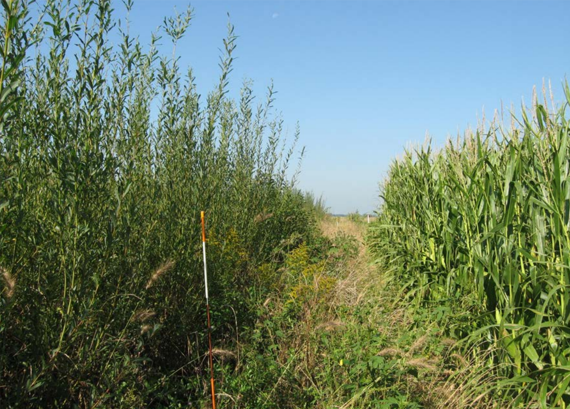
Researchers recently completed a study that investigated whether willow shrubs could make good living snow fences. While typical snow-fence plants, such as dogwood or cranberry shrubs, can take five to 20 years to establish themselves, shrub willows were effective at trapping snow after just two growing seasons, according to the study.
In spring 2013, researchers installed three varieties of shrub willow side-by-side in two-row and four-row configurations along about a quarter of a mile of Highway 14 in Waseca, where snow drifts are an issue. In April 2014, they cut the shrubs down to the ground to encourage branching and bush density. Though the trimmed willows had little impact on drifting snow the first winter, each willow-shrub plot was collecting two to three metric tons of snow by the second winter, according to the research report. Researchers believe that after three or four growing seasons the willow shrubs could catch the entire mean annual snowfall on the site.
In the four-row configuration recommended by researchers, costs of raising, furnishing, planting and mulching came to about $3.60 per plant, which is dramatically less than the contract bid cost for traditional living snow fence species that cost more than $50 per plant. In addition, the willow shrubs could be harvested and sold as biomass every few years to provide an income source.
Past research
Willow trees is just the latest advancement in the state’s snow control program. A 2012 research project evaluated the costs and benefits of living snow fences and provided MnDOT with a payment calculator to determine how much to compensate landowners for installation and maintenance costs.
A recent research implementation project created a mobile-friendly Web version of the payment calculator tool. The website also contains a tool for designing a own snow fence.
MnDOT has used these tools and other promotional efforts to nearly double the number of farmers with contracts for corn rows enrolled in the Living Snow Fences program.
What’s next
The willow species recommended by researchers will be evaluated further in 2017 when they install it as a living snow fence on a new construction site on Highway 60 between Windom and Mountain Lake. Researchers also recommend a future study to compare volume of road salt use before and after installation. They also want to look into identifying appropriate buffer distances to keep willow roots from interfering with cropland root systems.
Resources
- Research Report 2015-46: Assessing the Use of Shrub-Willows for Living Snow Fences in Minnesota
- Technical Summary 2015-46TS: Shrub Willows Make for Effective, Inexpensive Snow Fences in Minnesota
- Webinar: Snow Control Tools (Dec. 2, 2015)
- Webinar: Shrub Willows for Living Snow Fences (Dec. 2, 2015)
- Technical Summary 2015-21TS: Putting Research Into Practice: A Web-Based Cost-Benefit Tool to Expand the Living Snow Fence Program
- Technical Summary 2012-03TS: Evaluating the Costs and Benefits of Living Snow Fences
- Living Snow Fences web page (MnDOT)
- Blowing Snow Control Tools website (University of Minnesota)

Taking the guesswork out of measuring winter operations
Being able to accurately and reliably estimate traffic conditions during snow events is critical to transportation agencies. Typically, state DOTs use measurements such as “time to bare pavement”—based on the visual inspection of plow drivers—to gauge the progress of snow operations. These estimates are limited, however, by the subjectivity and inconsistency of human-based measurements.
Now, new research sponsored by the MnDOT and led by University of Minnesota Duluth civil engineering professor Eil Kwon aims to take the guesswork out of assessing traffic conditions during winter weather events.
“Dr. Kwon’s research on a new approach to snow and ice performance reporting is exciting,” says Steve Lund, state maintenance engineer and director of the Office of Maintenance at MnDOT. “For quite a few years, MnDOT snowfighters have been reporting their performance through a visual review of the roadway conditions. Our snowfighters have a tough job—automating the performance reporting will remove that task from their duties. Also, looking at traffic returning to a ‘normal’ condition is truly the ultimate goal or outcome measure, and where we want to go.”
In the first phase of this project, researchers developed a prototype process that uses data on traffic speed, flow, and density collected by loop detectors in the Twin Cities metro area to estimate the point at which traffic patterns return to normal—an indicator that the roadway surface has “recovered.” In the newly published second phase, researchers further analyzed the traffic flow patterns during snow events under normal and snow conditions and refined the earlier prototype into a traffic-data-based measurement process for snow operations.
“We found that by comparing the variation patterns in traffic flow during a snow event with those during normal weather conditions, we could successfully identify the recovery status of the traffic flow at a given location,” Kwon says.
Based on their findings, the researchers developed a new process to identify the Normal Condition Regain Time (NCRT)—as an alternative to the traditional “time to bare pavement” measurement used to gauge the progress of maintenance operations during a winter weather event.
One advantage of the new process is that it can reflect how road surface conditions affect traffic flow differently during day and night periods. “Nighttime traffic flow patterns are substantially different from those during daytime periods,” Kwon says. “We identified normal traffic patterns separately for daytime and nighttime conditions to account for these differences in estimating the recovery status.”
Future research plans include the development of an operational version of the NCRT estimation system that can be used on a daily basis to analyze and improve snow operations, and the creation of an online version that can be used for coordinating snow operations in real time.
“There is a lot of potential to use these findings to make snow operations even more effective and efficient,” Kwon says. “For example, the analysis of the relationship between the NCRT measures and operational strategies such as plowing start time and methods could help further refine MnDOT’s winter maintenance strategies.”
For more information, download the technical summary (PDF) or the project’s final report.
