Tag Archives: AVL

Researchers Dig Deeper into AVL/GPS Use in Winter Maintenance Operations

The Minnesota-led Clear Roads winter maintenance program has profiled six state agencies’ experience with automatic vehicle location (AVL) and GPS in winter maintenance fleets to share best practices with other cold weather states. Strong support by these agencies drives robust use of the technologies for location tracking, asset monitoring and planning for future storms.

AVL and GPS have been widely embraced in winter maintenance operations by transportation agencies around the country. But tracking vehicle locations for operational and safety reasons only scratches the surface of these systems’ potential uses. Many agencies also use AVL/GPS to collect extensive data for planning, operations, safety and inventory tracking to improve efficiency and response strategies.

Need for Research

AVL and GPS have been used in winter maintenance operations for several years. While most agencies use AVL/GPS for tracking vehicle location, the technologies offer operational, safety, inventory and planning applications, as outlined in a 2016 Clear Roads synthesis report. How agencies actually employ these automatic data collection technologies has remained less well-known.

Objectives and Methodology

The goal of this project was to explore agencies’ experiences and best practices in planning, implementing and using AVL/GPS technologies for winter maintenance activities. The investigation began with a survey of state and selected metropolitan transportation agencies about their level of commitment to AVL/GPS implementation and the data the agencies collect, use and share.

Investigators worked closely with Clear Roads to identify levels of usage of the technologies. Then they selected six agencies that represented various commitment levels, interviewed staff from each agency and gathered relevant documents about agency use of AVL/GPS. Using the information obtained during the interviews, researchers prepared case studies of each agency and recommendations for other agencies to further implement and utilize the technologies.

AVL/GPS hardware installed below and behind the seat in a snowplow
AVL/GPS hardware in this Sawyer County, Wisconsin, snowplow mounts below and behind the seat—a secure position that does not inconvenience the operator.

Results

Twenty-seven of the 38 agencies that responded to the survey reported using AVL/GPS to automatically collect winter maintenance data, while 36 of the 38 agencies indicated plans to add or expand use of the technologies in the future. Based on feedback from these agencies, researchers developed three levels of AVL/GPS use and categorized agencies according to the appropriate level.

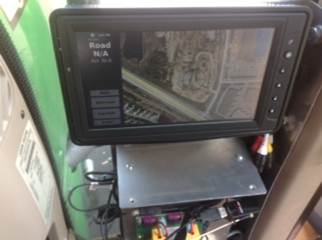
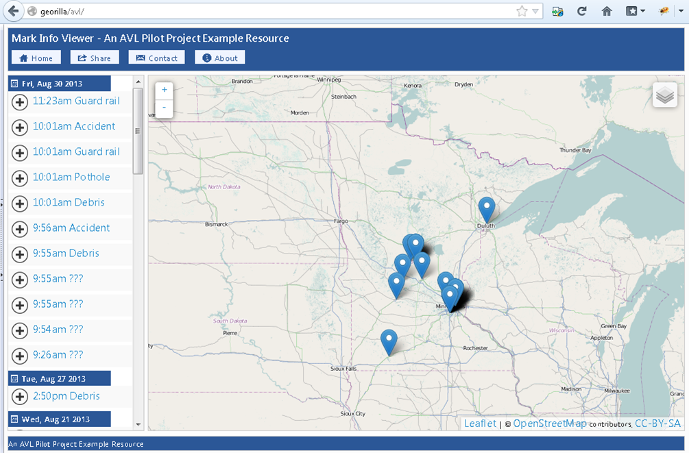
Tier 1 agencies employ AVL/GPS for basic location tracking or monitoring. Utah DOT has mounted AVL/GPS behind the dashboard of every snowplow and incident maintenance truck (vehicles that assist stranded motorists on Utah’s roads and highways) in its fleet. The system connects with plow position sensors, tracks idling time and traveling speed, and reports plow locations on a publicly accessible website.

Tier 2 users add basic data collection, equipment integration and system reporting features to Tier 1 usage, often in concert with other technologies. Washington State DOT’s Tier 2 usage integrates AVL/GPS with spreader controllers, plow position sensors, and air and pavement temperature sensors in 80 percent of its fleet to track material use, road weather and operational analysis data. Michigan DOT integrates AVL/GPS with spreaders, plows and dashcams in 94 percent of its fleet to track vehicle location, vehicle diagnostics and material use, and to use for operational analysis and information sharing with the public.

Tier 3 agencies conduct complex data collection, integration and reporting activities with AVL/GPS as part of a suite of instruments and applications that collect and transmit data to users, the agency and, in some cases, the public. Colorado DOT (100 percent of its fleet), Nebraska DOT (33 percent) and Wisconsin DOT (53 percent) link AVL/GPS to data collectors, plows, spreader controllers, pavement and air temperature controllers, and other equipment. Each agency tracks vehicle location, material use, treatment recommendations, vehicle diagnostics and data for operational analysis, among other uses. Colorado and Wisconsin DOTs share data with a maintenance decision support system; Colorado DOT also shares information with the public.

Keys to success with AVL/GPS include obtaining full organizational and financial support from agency management, piloting the system with vendors and operators to identify objectives for use, providing operators with training that emphasizes the technologies’ operational and safety benefits, involving agency mechanics in installation, and using the system data for real-time adjustments to maintenance and resource-allocation strategies.

“The recommendations were very constructive— everything from planning and decision-making to how to best collect data and use it for performance measurement,” said Project Champion, Patti Caswell, Oregon Department of Transportation.

Benefits and Further Research

The final report offers information that will be useful to prospective and current adopters, describing best practices in AVL/GPS planning and implementation, procurement, installation, training, data collection and utilization, and operations and maintenance.

Future research may evaluate methods for integrating technologies from various manufacturers into a cohesive, operational system. Turnkey options remain limited, and integrating sensor, camera, data collection and GPS presents a number of technical challenges. Related study may evaluate communication terminology for uniform data
sharing between agencies. Follow-up research could also identify the costs and benefits of AVL/GPS to quantify the value of these technologies to users.

Connected vehicle technologies, which use roadside units to communicate with other roadside units and wirelessly with vehicles, offer potential applications for real-time data collection and sharing among plow operators and other stakeholders. The relative value and ability to implement such systems may warrant research and comparison to
AVL/GPS.

This post pertains to Strong Agency Support, Multiple Applications Drive AVL/GPS Use , published October 2018. The full report and presentation can be accessed at  Project 16-01, Utilization of AVL/GPS Technology: Case Studies.

Adding Snowplow Camera Images to MnDOT’s Traveler Information System

MnDOT installed network dash cameras and ceiling-mounted cameras on 226 snowplows, approximately one-quarter of MnDOT’s snowplow fleet. The cameras, integrated with the onboard mobile data computer and automated vehicle location equipment, automatically captured snapshots of road conditions during plowing. The snapshots were incorporated into several facets of MnDOT’s 511 traveler information system: the desktop and mobile versions of the website and the 511 app. Motorists and MnDOT alike found the project to be valuable, with the up-to-the-minute imagery helping members of the public and MnDOT’s maintenance staff make well-informed decisions during winter storm events.

“The largest barrier to implementation involved the development of the software package for integrating snowplow cameras into the current AVL system. It required a great deal of back-and-forth to get things right,” said oe Huneke, Maintenance Decision Support Systems (MDSS)/AVL Section Manager, MnDOT Office of Maintenance.

“We did research to make sure the cameras did not block drivers’ views, taking state and federal regulations into consideration, and we tested the cameras to make sure they were capturing images at the right resolution,” said Jon Bjorkquist, Maintenance Technology Development/ Implementation Coordinator, MnDOT Office of Maintenance.

What Was the Need?

Reliable information about road conditions during winter weather allows motorists to make informed travel decisions and helps MnDOT responders maintain roads. While meteorological updates on a winter storm and automated status reports on Minnesota’s snowplow fleet are important sources of data, they do not provide visual information about road conditions.

In 2015, a pilot project allowed MnDOT to take road condition pictures from cameras mounted on selected snowplows during winter storms. The system was limited, however. Few snowplows were outfitted with these cam-eras, images were not available to the public, and network infrastructure did not allow for easy scaling. A larger scale program was needed to capture road imagery taken from snowplows across Minnesota and to share the pictures with Minnesota motorists.

What Was Our Goal?

MnDOT sought to install cameras on a sizable portion of MnDOT’s snowplow fleet. In addition to making hardware and network enhancements to collect and compile the image data, MnDOT also set out to make the photos avail-able in near-real-time to its internal maintenance staff and the traveling public.

Camera mounted on the ceiling of a MnDOT snowplow cab.
To capture images of road conditions, MnDOT mounted cameras in the cabs of one-quarter of MnDOT’s snowplow fleet.

What Did We Do?

In 2015 and 2016, MnDOT installed network dash cameras and ceiling-mounted cameras on 226 snowplows, approximately one-quarter of the agency’s total snowplow fleet. The cameras, integrated with the onboard mobile data computer and automated vehicle location (AVL) equipment, automatically captured snapshots of road conditions during plowing. This system included the following key operational features:

  • The dash cameras automatically recorded images whenever the computer-AVL system was on.
  • The cameras recorded an image of the road ahead of the plow.
  • Images were taken once every five minutes and were only retained if the plow was moving at least 10 mph.
  • The cameras were capable of taking operator-initiated snapshots and video clips.
  • Video clips could be classified into three categories: accident, general interest or work zone.

The system sent the plow camera images and metadata (geolocation, plow, camera and conditions) to a MnDOT server upgraded to accommodate the data. MnDOT set a data retention schedule for mobile snapshots and video segments as well as the data server.

Plow images were incorporated into several facets of MnDOT’s 511 traveler information system, including the desktop and mobile versions of the website and the 511 app. Plow images plotted at 10-minute intervals on the 511 maps provided motorists with up-to-the-minute, easily accessible information on road conditions. The images were also incorporated into MnDOT’s internal website called Condition Acquisition and Reporting System.

What Did We Learn?

The project demonstrated the successful integration of various hardware, software and network systems, carrying the road weather imagery step by step from the cameras to the public 511 interface. The project also succeeded in scaling up an earlier, modest effort to furnish snowplows with cameras.

In addition, MnDOT collected input on the value of the cameras from a range of interested parties: the public, snowplow operators and supervisors, and MnDOT management staff.

The public response was overwhelmingly positive, with 319 Facebook users responding to a MnDOT post about the cameras. All the respondents used positive emote icons (“heart” or “thumbs up”). Several members of the public provided responses through Facebook and MnDOT’s “Contact Us” Web page about the value of being able to view actual road conditions, though others expressed concern about the cost of the system.

Surveys of MnDOT snowplow drivers and supervisors and interviews of MnDOT managers revealed that supervisors and managers had a largely positive view of the program as well. Drivers provided mixed reviews. Comments from these groups yielded the following recommendations about implementing a program of this nature:

  • Perform outreach efforts that clearly communicate benefits to achieve broad buy-in from snowplow drivers. Provide training and follow-up instruction on use of the cam-era’s features to encourage drivers to use the manual snapshot and video features.
  • Address drivers’ concerns about privacy (such as “Big Brother is watching”) directly, and understand that these concerns have lessened over time. Supervisors should be advised not to react too quickly to privacy concerns.
  • Address concerns about in-cab distraction by adjusting the system configuration or hardware. This might include making dash camera screens dimmable at the driver’s option, or placing screens and cameras out of critical sightlines.

What’s Next?

This project was a success, with snowplow camera images providing significant benefits to MnDOT staff and the traveling public. Based on this work, MnDOT plans to install camera systems on additional snowplows in the state fleet—as deemed necessary by district management—and to continue displaying snowplow images on MnDOT’s 511 system.


This post pertains to Report 2017-41, “Installing Snowplow Cameras and Integrating Images into MnDOT’s Traveler Information System,” published October 2017.

AVL Technology Enables Smarter, More Efficient Mowing Operations

A pilot project was begun to study the use of AVL technology in mowing operations. Potential benefits include improved mowing efficiency, improved reporting and ease of supervision, reduced paperwork and reduced spread of noxious weeds.

“Using the data we get from the AVL project, we can estimate how long it will take to mow the entire system,” said Douglas Maki, Asset Management Engineer, MnDOT Metro District. “That way, we can plan far in advance of major holidays, when the most traffic comes through our system.”

“The AVL technology can be used to mark newly disruptive weed locations and anything else a mower operator might see, like potholes, damaged signs or guardrails, and excessive or dangerous debris in the field,” said Adrian Potter, Senior Associate, SRF Consulting Group, Inc.

Potter served as the project’s principal investigator.

What Was the Need?

MnDOT is responsible for mowing roadsides along 14,000 centerline miles of highways for environmental and safety reasons. This is an enormous and critical task, requiring efficient use of employee time and mowing equipment, and efforts to avoid the spreading of noxious weeds, which will lead to increased use of herbicides.

A promising technology that many departments of transportation (DOTs) have installed is automated vehicle location (AVL). AVL systems provide a precise geographic location for DOT-owned vehicles so that real-time data can be obtained on field operations. This technology has been used for snowplowing and other fleet vehicle operations. However, only a few DOTs have used it for mowing operations.

To determine if AVL technology should be used in its
mowing operations, MnDOT undertook a pilot project involving 30 of its mowers. The locations chosen were Metro District roadsides, as MnDOT had previously invested in creating a geographic information system map of noxious weeds on those roadsides.

What Was Our Goal?

The goals of the pilot project were to:

  • Generate protocols for hardware installation and software training.
  • Set up the system for communicating data from the mowers to internal MnDOT servers.
  • Develop accomplishment reports based on data collected by the AVL units.
  • Develop and provide initial training to operators and supervisors.
  • Optimize the mower routes used.

What Did We Do?

For the 2015 and 2016 mowing seasons, researchers fitted 30 Metro District tractors with AVL technology, sensors and communication equipment.

The first stage of the project focused on developing the software interface required for the AVL system. The application had to provide a view of the mower’s exact location so that the mower operator could avoid noxious weeds. Data would be collected through an in-vehicle controller unit and transferred to MnDOT for analysis via a Verizon AirCard system installed on each mower.

Mechanics installed metal racks within each of the 30 mowers to protect the Ameritrak AT-500 AVL hardware unit. A video screen was mounted on the top of the rack. A reporting system was developed for use by operators, supervisors and managers. Training sessions were scheduled at the start of each season and when new operators were hired.

Interior view of mower cab showing location of AVL unit.

What Did We Learn?

The project achieved its initial goals of developing protocols for hardware and software, creating electronic reporting and capturing real-time data.

The research team gained the following insights during the planning and field-testing stages of the project:

  • Substantial time is needed to adequately develop and test the AVL software and hardware.
  • Implementing the system also requires considerable time due to resource limitations, and after implementation, it takes multiple mowing seasons to quantify weed and herbicide reductions.
  • MnDOT mower operators and supervisors recognized the value of the AVL system in improving the efficient use of their time, eliminating the drafting of written reports, and giving MnDOT a more accurate record of acreage mowed.
  • Since the tractors operated at such slow speeds, the initial data captured were too imprecise to analyze. But with software adjustments, this issue was resolved.
  • Installation of the AVL unit could have an impact on the operation of the tractor because the additional electrical burden that the unit places on the tractor battery may require the tractor to be sent to the manufacturer for inspection.

What’s Next?

The initial success of the pilot project provided the basis for continued use of AVL technology in Metro District mowing operations during the 2017 season and possibly beyond. MnDOT is currently evaluating whether this project has provided enough data to expand AVL to other districts in the state. The investigators estimate that after full implementation, MnDOT could save $100,000 per year.

MnDOT may consider installing AVL technology in other agency equipment to optimize and monitor maintenance activities.


This Technical Summary pertains to Report 2017-11, “An Innovative Approach to Smarter Mowing, Utilizing Automated Vehicle Location to Enhance Mowing Operations,” published April 2017.

Additional materials:

Knowing While Mowing: GPS Keeps Maintenance Workers Out Of the Weeds

As temperatures fall and days get shorter, MnDOT Metro District maintenance workers are wrapping up a season of mowing grass along roadsides and in medians that they hope will prove a little more efficient than in the past.

Thanks to a research project that installed GPS devices in tractor cabs, operators have a better sense of exactly which areas they need to mow and which areas should be left alone. Five Metro District tractors were tested in 2015. This year, more than 40 tractors were fitted with the automated vehicle location (AVL) technology, which includes a GPS antenna, an on-board central processing unit (CPU) and an in-cab screen with a user interface.

Trisha Stefanski, Metro District asset management engineer, expects one of the biggest benefits of the project to be a reduction in herbicide use. Maintenance crews use herbicide to control the spread of noxious weeds that sometimes get spread during mowing operations. Mapping exactly where noxious weeds are, and providing that information to operators on a real-time, in-cab screen and user interface helps them mow around those areas.

“We’re really hoping it will reduce the amount of herbicide that we’re putting on our roadways by 50 percent,” Stefanski said. “We’re not certain that will be the number, but that’s what we’re hoping for. We think just not mowing those areas will not spread as many noxious weeds and so we don’t have to apply as much herbicide.”

Metro District operators, such as Jesse Lopez, give the AVL technology rave reviews.

“Basically you can see what you shouldn’t mow and what you should mow. So, it makes it easy for me. It’s just like playing a game,” Lopez said. “This actually helps me to optimize what my job is. I know exactly where I’m at and where I’m going. I think everyone should use it – absolutely everybody who is in a mowing situation or a plowing situation.”

In addition, the AVL technology helps maintenance supervisors keep tabs on exactly where their operators are in real time. It also helps supervisors complete reports by automatically providing the geographic areas where mowing has been completed.

Stefanski says the project has gone really well, and she hopes collecting more data over another mowing season will show real savings on herbicide use. In the meantime, she is thinking of other ways AVL technology could be applied to maintenance operations.

“What I really like about the project is that we are taking something used in a lot snow plows and a lot of other technologies – cars, other things, maybe UPS uses them – and we’re putting it into maintenance operations,” Stefanski said. “Having it for mowing, we can also use it for smooth pavements. We can also use it for other things in mowing operations.”

GPS-equipped mowers to save money, reduce noxious weeds

Putting GPS units on MnDOT highway mowers is expected to speed mowing operations and cut herbicide usage by 50-percent in metro area ditches, reducing groundwater contamination.

MnDOT’s Metro District highway maintenance division will be one of the first — if not the first — state agencies in the country to equip the majority of its maintenance tractors with Automated Vehicle Location systems.

Not only will crews be able to effortlessly track their progress — reducing paperwork and freeing time for other maintenance activities — but the AVL’s live mapping software will help them avoid noxious weed patches, thereby reducing their spread.

Last year, MnDOT tested the GPS software on five mowers.

“AVL alone enables the tracking of vehicle positions, but when combined with equipment sensors and an on-board monitor with user interface, it becomes a very innovative way to reduce operation costs,” said MnDOT Project Engineer Trisha Stefanski, who applied for funding from MnDOT’s Transportation Research Innovation Group for the pilot project.

Vehicle tracking systems have been shown to reduce chemical usage by crop farmers, improve route efficiencies in truck driving and help cities and counties track snowplows.

The on-screen mapping shows the location of weed patches, so mowers can avoid them, reducing their spread.

MnDOT Metro, which tested five AVL units last year, hopes to equip as much of its remaining fleet as possible.

In the grant application, Stefanski estimated the technology will pay for itself in about a year’s time, largely due to herbicide savings.

Noxious weeds

MnDOT is required by law to manage certain noxious weeds along its highways. Each year, weed inspectors survey one-quarter of metro ditches for weeds, which enables them to concentrate eradication efforts on the worst areas.

Touch-screen maps will contain the noxious weed locations so operators can see weed patches and mow around them.

Herbicide usage is estimated to drop an estimated $100,000 to $150,000 per year. (This estimate was based on the original funding request. Final numbers haven’t been released.)

Operators can use the on-screen map to mark the location of new patches of noxious weeds.

Noxious weeds like Wild Parsnip — which can cause painful skin boils — might even be eradicated, reducing the risk for field crews, such as construction workers and Adopt a Highway volunteers.

Until now, maintenance crews have relied on paper maps to identify weed locations, which is less effective.

“What’s better, looking at a live screen when you’re going down the road and seeing where weeds are coming up, or trying to refer to a piece of paper?” Stefanski said.

Other advantages

The AVL equipment will also allow for automated reporting.

Mower operators can use the on-board AVL monitor to mark the location of guardrail hits, potholes, washed-out culverts, debris and unmarked noxious weeds.

Operators can electronically mark the location of guardrails, debris, potholes and more.

Currently, operators must track their activities using hand-written forms or spreadsheets in the office.

The AVL system will also automatically track their location history, allowing operators to optimize their routes based on how long it took to mow segments in the past.

It will also be easier to answer questions from the public, who want to know the last time a certain ditch was mowed.

“Making everything geographically located adds so much analysis opportunity,” Stefanski said.

MnDOT also has AVL technology on an herbicide applicator to better track where it’s sprayed. Other future potential applications including pothole patching and road sweeping operations, Stefanski said.