

Putting GPS units on MnDOT highway mowers is expected to speed mowing operations and cut herbicide usage by 50-percent in metro area ditches, reducing groundwater contamination.
MnDOT’s Metro District highway maintenance division will be one of the first — if not the first — state agencies in the country to equip the majority of its maintenance tractors with Automated Vehicle Location systems.
Not only will crews be able to effortlessly track their progress — reducing paperwork and freeing time for other maintenance activities — but the AVL’s live mapping software will help them avoid noxious weed patches, thereby reducing their spread.
“AVL alone enables the tracking of vehicle positions, but when combined with equipment sensors and an on-board monitor with user interface, it becomes a very innovative way to reduce operation costs,” said MnDOT Project Engineer Trisha Stefanski, who applied for funding from MnDOT’s Transportation Research Innovation Group for the pilot project.
Vehicle tracking systems have been shown to reduce chemical usage by crop farmers, improve route efficiencies in truck driving and help cities and counties track snowplows.

MnDOT Metro, which tested five AVL units last year, hopes to equip as much of its remaining fleet as possible.
In the grant application, Stefanski estimated the technology will pay for itself in about a year’s time, largely due to herbicide savings.
Noxious weeds
MnDOT is required by law to manage certain noxious weeds along its highways. Each year, weed inspectors survey one-quarter of metro ditches for weeds, which enables them to concentrate eradication efforts on the worst areas.
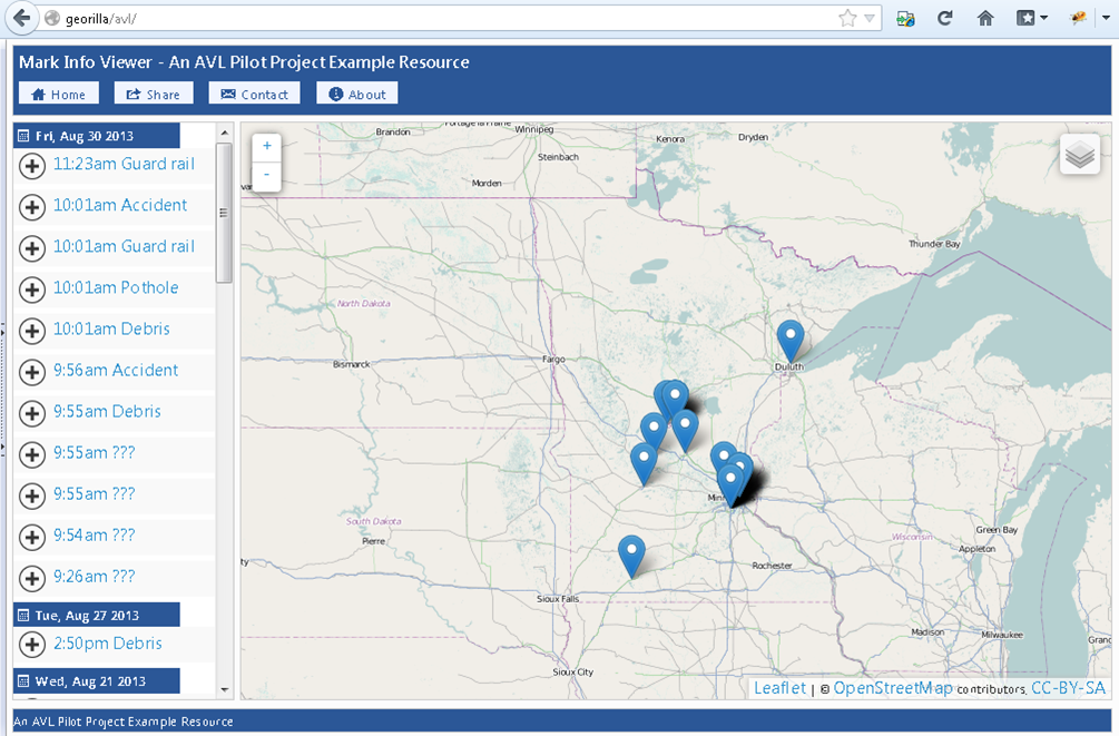
Touch-screen maps will contain the noxious weed locations so operators can see weed patches and mow around them.
Herbicide usage is estimated to drop an estimated $100,000 to $150,000 per year. (This estimate was based on the original funding request. Final numbers haven’t been released.)

Noxious weeds like Wild Parsnip — which can cause painful skin boils — might even be eradicated, reducing the risk for field crews, such as construction workers and Adopt a Highway volunteers.
Until now, maintenance crews have relied on paper maps to identify weed locations, which is less effective.
“What’s better, looking at a live screen when you’re going down the road and seeing where weeds are coming up, or trying to refer to a piece of paper?” Stefanski said.
Other advantages
The AVL equipment will also allow for automated reporting.
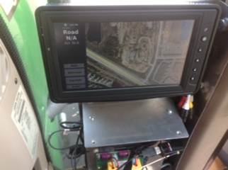
Mower operators can use the on-board AVL monitor to mark the location of guardrail hits, potholes, washed-out culverts, debris and unmarked noxious weeds.
Currently, operators must track their activities using hand-written forms or spreadsheets in the office.
The AVL system will also automatically track their location history, allowing operators to optimize their routes based on how long it took to mow segments in the past.
It will also be easier to answer questions from the public, who want to know the last time a certain ditch was mowed.
“Making everything geographically located adds so much analysis opportunity,” Stefanski said.
MnDOT also has AVL technology on an herbicide applicator to better track where it’s sprayed. Other future potential applications including pothole patching and road sweeping operations, Stefanski said.

How much datas needed for this GPS system. The AVL reporting is monthly or day . How much storage needed for this ??
Great questions! Checking into this for you.
Hi Shawn, I didn’t get the exact answer to your question, but I can put you in touch with someone, if you want to dig deeper. They did say that the data came through fine, though users may need to slice it up into smaller sections if they want to export the data. The AVL reports have an upper limit on how much data can be exported at one time.