All posts by Shannon Fiecke

Marketing and Communications Manager, MnDOT Research Services

Reducing construction pollution by skimming stormwater ponds

Soil carried away in stormwater runoff from road construction sites can pollute lakes and rivers.

Stormwater settling ponds provide a place for this sediment to settle before the water is discharged into local bodies of water. However, since stormwater ponds have limited space, a mechanism is needed to remove clean water from the pond to prevent the overflow of sediment-laden water.

MnDOT-funded researchers have designed temporary stormwater ponds with floating head skimmers that can remove clean water from the surface of the settling pond, using gravity to discharge water into a ditch or receiving body.

The Marlee Float from the SW Fee Saver is one of five currently available floating-head skimmers that researchers identified.
The Marlee Float from the SW Fee Saver is one of five available floating-head skimmers that researchers identified.

This is a new approach for MnDOT and Minnesota cities and counties, so research was needed to provide practical guidance for how to use these devices on construction sites.

“This was a small-scope implementation project for professionals to use as they design temporary stormwater ponds that meet state parameters,” said Dwayne Stenlund, MnDOT Erosion Control Engineering Specialist.

A new MnDOT study identifies five methods for “skimming” stormwater ponds that can improve a pond’s effectiveness by 10 percent. MnDOT researchers also created designs for temporary stormwater ponds on construction sites with the capacity to remove approximately 80 percent of suspended solids.

These designs will help contractors meet federal requirements for stormwater pond dewatering. Researchers also determined how often a pond’s deadpool must be cleaned, based on watershed size and pool dimensions.

“When sediment settles, it’s hard to determine when to clean out a pond. Based on the density of the sediments in the Minnesota River and the loading rates we computed, we were able to calculate how often we need to clean out a pond so sediment doesn’t reach the height of the skimmer,” said Joel Toso, principal of Wenck Associates and a consultant for the project.

Resources

Reducing Construction Pollution by Skimming Stormwater Ponds – Technical Summary (PDF, 2 MB, 2 pages); Final Report (PDF, 3 MB, 43 pages)

LRRB web tool tracks research projects around the state

As public works employees come and go, past research efforts — and the valuable knowledge gained — often goes with them.

But a recently launched web application allows users to track innovative pavement projects for a lifetime.

“It’s something everyone has always said we need to have,” said MnDOT Research Operations Engineer Jerry Geib, who worked on the project for the Minnesota Local Road Research Board.

Using an online map, city and county engineers can enter road test sections that they want to observe for many years due to a particular construction method or material that was used. Too often, the knowledge about such projects is lost when a particular staff person leaves an agency.

Not only will the lessons learned be remembered within the organization, but the results can also be shared with others.

More than 1,400 projects (including some on state roads) previously identified by MnDOT have been entered into the system. Search fields allow users to look for a particular type of project anywhere in the state or they can zero the map in on a particular area of the state.

The website is still in beta form, but functional.

“It’s complete, we just want people to use it so we can improve it,” said MnDOT Research Project Engineer Melissa Cole, who began planning the site two years ago.

One featured project is a 1.8-mile section of dirt road in Wabasha County that had an Otta seal applied in 2007 (photo below). It is one of only a handful of lightly surfaced roads in the state (an improvement over a gravel road, but less expensive than asphalt ) so there is great interest in watching how it performs.

One of the projects being tracked is Wabasha County Road 73, one of only a couple lightly surfaced (Otta seal) roads in the state.
One of the projects being tracked is Wabasha County Road 73, one of only a handful of lightly surfaced (Otta seal) roads in the state.
More to come

The LRRB initiated the project in 2009, but it was put on the back burner for a while due to funding constraints. MnDOT ‘s technology staff began development of the current site about 11 months ago.

Anyone can look at the website, but cities and counties require permission to post projects (contact ResearchTracking.DOT@state.mn.us for credentials). They  can upload photos, plans and weblinks relating to a particular project.

“We want to track anything that is worthy of looking at a few years from now,” Geib said.

Because the website uses Google maps, users can also view archived satellite and ground-level 360-degree imagery of the roads and bridges.

The website is viewable on a tablet, but it still must be tested on smart phones. Developers hope that crews will be able to submit information right from the field.

“We’re pretty happy with it,” said MnDOT software developer John Jones. “We think we’re headed in the right direction.”

The website might eventually be expanded for other areas, such as geotechnical (foundation work), whose practitioners have already expressed an interest.

A rumble strip applied to a center line on Highway 14 near New Ulm in 2004 is being tracked.
A rumble strip applied to a center line on Highway 14 near New Ulm in 2004 is one of the projects being tracked.

Behind the bridge slide: dish soap and a lot of planning

Using Dawn dish soap to grease the rails, MnDOT crews inched the new Larpenteur Avenue Bridge into place two weeks ago using an innovative construction method.

As the bridge reopens to traffic tonight over I-35E, MnDOT celebrates the success of its first slide-in place bridge construction.

“The slide-in worked very well,” said David Herzog, MnDOT’s project manager for the I-35E Corridor – MnPass Project. “I think the process has given us the confidence to possibly use it again in the future.”

Slide-in technology

The slide-in method has been used in the past for railroad bridges and large bridges with high traffic and limited construction options. Now, state agencies and the Federal Highway Administration are applying the method to smaller, more routine bridges to minimize impacts to the traveling public.

Whereas the typical phased construction of a bridge builds one-half of the structure at a time, slide-in bridge technology allows the entire superstructure to be built at once, requiring just a brief, temporary closure of the highway.

Crews constructed the 3.5-million-pound Larpenteur Bridge right next to the existing bridge and then slowly slid it into place during the course of two nights. This effectively sped up construction from 110 days to 47 and reduced traffic impacts to drivers. (Watch video of the slide.)

The quality of the bridge also improves with this method, since it eliminates the deck construction joints and girder camber problems associated with phased construction, according to the FHWA. The pressure to use faster concrete cure times is also reduced.

History

With a quarter of the nation’s bridges in need of repair or replacement, the FHWA is pushing the slide-in method as a cost-effective technique that can cut construction time in half. It has previously been used in Oregon, Utah, Missouri, Michigan, Colorado and Massachusetts.

The concept has been around for more than a century, but slide-in technology is relatively new for small or medium-sized bridges, and it’s the first time MnDOT has attempted it on a state bridge.

Although MnDOT staff had flown out to Utah to view a slide-in, it was Burnsville-based Ames Construction that proposed reconstructing the Larpenteur Avenue bridge that way when it made its successful bid for the corridor project.

The slide-in method is about 15 percent more expensive, Herzog said, but it allowed the bridge to re-open in 47 days, versus 110 days.

Earlier this summer, Ames replaced the Wheelock Parkway and Arlington Avenue bridges in conventional fashion, although they were only closed for 65 days because they were constructed on a very accelerated timetable.

“Larpenteur is more of a major thoroughfare and we thought shortening the duration of its closure would be more valuable to  MnDOT,” said Steve McPherson of Ames Construction, who was brought in from Utah to oversee the corridor project.

The fast reconstructions will allow the company to complete the bridge replacements and highway reconstruction in just 120 days. Next year it’ll finish the other half of the corridor.

All three bridges are being replaced to make room for the new MnPASS lane on I-35E.

One of the drawbacks to slide-in technology is that it requires ample room to build the bridge on-site. An alternative is to construct off-site.

The new Maryland Avenue/I-35E bridge was built off-site, as was the Hastings Hwy. 61 bridge. It was then loaded onto a barge, floated down the Mississippi River and lifted into place.

Related Resources

MnPASS: Two systems, both work

I-35W’s MnPASS lane, where vehicles can frequently enter and exit the high-occupancy toll lane, is just as safe as the MnPASS lane on I-394, where motorists only have a few shots to enter the system, a new study finds.

Researchers at the Minnesota Traffic Observatory undertook the MnDOT-funded study because of objections to open systems like the one on 35W.

“The federal government has very strong arguments against the open system. They’re saying it’s going to be dangerous – cause more disruption and more congestion,” said John Hourdos, director of the Minnesota Traffic Observatory. “We found that both roadways are working very well today because they were designed appropriately for their location.”

The definition of an open system is one that has more opportunity for access than restriction. On 35W, a dotted white lane means vehicles can enter the toll lane at will, and a solid line bars access.

Vehicles must have two occupants on-board or an electronic pay card to use the express lanes during rush hour.

MnPASS on Highway 35W.

The reason I-35W allows vehicles to enter MnPASS more frequently than I-394 is because there are more ramps where new vehicles are entering the freeway and might want to get on MnPASS.

Researchers studied whether accidents are more likely to occur by studying the number of accident-inducing vehicle movements along the 35W corridor. They found that areas where accidents are mostly likely to occur are also where the lane would have to allow access anyway under a closed system like 394.

The study also looked at mobility, determining that MnPASS users have just as good free-flowing traffic under the open system.

Helpful tools

Researchers also created design tools that engineers can use to determine where access points should be on MnPASS lanes.

Until now, engineers have relied on rule of thumb. For example, the general guidance for allowing access on a closed system was 500 feet for every lane between the entrance ramp and the HOT.

The tools can be used to automatically determine how fluctuations in the MnPASS fee will affect congestion within the lane.

The fee to use MnPASS depends on the time of day.

As the express lane become more congested, the fee to use it increases. This slows the number of cars entering the lane, increasing the speed of the vehicles already in the lane.

“We ran the tool on three locations on 35W and found that, for example, on Cliff Road, you can increase the traffic by 75 percent and still be okay,” Hourdos said. “You have more leeway there than north of the crossroads of Highway 62 and 35W, for instance.”

 Related Resources

What those signs over the freeway are actually telling you

Two years ago, MnDOT installed a series of electronic speed limit advisory signs over Interstate 94 between Minneapolis and St. Paul. The Variable Speed Limit (VSL) system is designed to reduce congestion and help prevent crashes by recommending lower speed limits to motorists during periods of high traffic.

The new technology has worked in other places, including China and Germany. In Minnesota, a similar VSL system on I-35W reportedly had moderate benefits in reducing the total amount of congestion during the morning commute south of Minneapolis.

Although the verdict on I-94 congestion is still pending,  a newly released study has found that the new system has not made a measurable impact so far on crashes in an accident-prone stretch of freeway in downtown Minneapolis. Why not?

University of Minnesota researcher John Hourdos has a few theories.

One is a simple time  lag in the congestion reporting system. Another is a requirement that all lanes display the same speed limit, which he said causes confusion when only one lane is actually congested. The complexity of the I-94 commons also appears to be beyond what the VSL system was designed to do. And according to Hourdos, one of the most significant problems is the driving public simply doesn’t understand what the signs are telling them.

“People do not know what the system really does,” Hourdos said. “There hasn’t been much education on it other than a couple of news articles over the years. And when they try to decipher it on their own they get even more confused.”

The I-94 Commons area has a major bottleneck where the I-35W northbound ramp merges with I-94 westbound (between Cedar Avenue and 11th Avenue). Vertical red lines indicate locations of gantries that display variable speed limit advisories.

The advisory speed limits are posted in response to varying traffic conditions. As vehicles approach the commons area, the system measures speeds at the bottlenecks. If the traffic slows, the system transmits a reduced advisory speed to drivers approximately 1.5 miles upstream from the location of the slow-down.

Hourdos said many motorists mistakenly believe the speed displayed on the signs is either a reflection of the speed on the current stretch of highway or an indication of the speeds on the highway ahead, rather than a suggested speed for them to follow.

The requirement to display the same speed limit on all signs also compounds the problem, Hourdos said, because when drivers see that the slowdown is only occurring in certain lanes they tend to ignore the signs altogether.

“In the lane that is congested, the real speeds drop much faster than what the VSL system can respond to, reducing the functionality of the system to the eyes of the drivers,” Hourdos said, “while on the fast-moving lanes, it seems the system has no purpose at all.”

From downtown Minneapolis rooftops, traffic monitoring cameras detect shockwaves on Interstate 94.
Data was primarily collected via cameras at the I-94 Commons’ Third Avenue Field station, overlooking an area with a particularly high crash rate.

So is the I-94 VSL system useless? Not necessarily. For one, the new study didn’t measure the system’s impact on congestion — only its ability to reduce crashes on a small portion of I-94. Moreover, the area in question, the I-94 Commons, is fairly unique, having two major bottlenecks, the highest crash rate in the state (nearly one every other day), and five hours of congestion during the afternoon rush hour alone.

“The VSL system was designed for implementation on any freeway and may not have been well-suited for the I-94 Commons area, which is a very complex corridor with high volume weaves and significant shockwave activity,” said MnDOT Freeway Operations Engineer Brian Kary.

Generally speaking, the VSL system was designed to identify slow traffic ahead of where free-flowing traffic is approaching slow or stopped traffic.

“The crash problems within the commons are caused by speed differentials between lanes and shockwave activity within the congestion,” Hourdos said. “The current VSL system was not developed to handle these types of conditions.”

MnDOT and the researchers aren’t giving up, either. A new project is starting later this year to develop and deploy a queue warning system specifically for this high-crash rate location.

Further resources

Investigation of the Impact of the I-94 ATM System on the Safety of the I-94 Commons High Crash Area (PDF), May 2014

Improving Traffic Management on Minnesota Freeways (PDF), May 2012

Study to develop bridge load limits for tractors

Minnesota farm equipment is getting larger and heavier, causing strain on rural bridges. However, there are no  nationally recognized specifications for what size and weight of tractors can safely travel over them.

Currently, bridge load limits are based off semi-trucks, not farm machinery, which have much different axle configurations and wheel dimensions.

“Their geometry is atypical; their length, widths are different; they have different suspension characteristics,” explains Brent Phares, director of the Bridge Engineering Center at Iowa State University.

A new pooled fund study led by the state of Iowa is attempting to determine how much stress heavy farm vehicles put on bridges. This data will be used by local agencies to develop weight restrictions specifically for farm equipment.

“It will help limit the confusion of current load posting signs for farmers,” said MnDOT bridge load rating engineer Moises Dimaculangan.

Wisconsin, Minnesota, Nebraska, Oklahoma, Illinois, Kansas and the United States Department of Agriculture are also participating in the study, which is examining three types of local bridge superstructures: those with steel girders and concrete decks; bridges with steel girders and timber decks; and timber bridges with timber decks.

Through physical testing and modeling, the study will determine how different types of farm machinery distribute their loads on the bridge superstructure.

About a half-dozen farm vehicles were tested on 20 different bridges which were representative of those tending to be the most problematic for farm equipment traffic on secondary road systems, Phares said.

Instrumentation measured the response of the structures to the vehicles. This data was then used as a baseline to calibrate analytical models, which could be applied to 250 different bridges and 121 different farm vehicles.

Researchers will develop a generic tractor profile, which represents the worst-case scenario, for use in determining load limits. With the information developed, signs might be able to be added to the bridges, which show a tractor and the weight limit.Collapsed bridge

“I get a number of pictures emailed to me of bridges that have failed with a tractor implement of husbandry on top,” Phares said. “That’s the problem that people are looking to avoid; the goal isn’t to restrict the size of farm vehicles, but to develop better tools for engineers to make sound and solid analyses for the bridges, so they can provide that information to the people who need to have it.”

Phares said a couple previous studies have also looked at farm machinery weight restrictions. One study, from around 2004, took a high level look at the impact of farm vehicles on bridges. A more recent pooled fund study analyzed the impact of machinery on pavements.

Related resources

Research in Progress: Study of the Impacts of Implements of Husbandry on Bridges

The Effects of Implements of Husbandry “Farm Equipment” on Pavement Performance

Peer Exchange: Pavement researchers face similar issues, financial pressures

Soaring construction costs and a rapidly aging infrastructure will require states to revolutionize how they maintain their roadways — but without each other’s help, they won’t be successful.

That was a key message from pavement researchers last week at a MnDOT-hosted peer exchange event, where pavement experts from around North America shared their ideas and research experiences.

“You’ve got to partner with other states, the FHWA and industry,” said Research Engineer Steve Bower of the Michigan Department of Transportation. “We can’t go it alone anymore.”

Researchers at the event reviewed recent pooled-fund studies conducted at MnROAD, MnDOT’s innovative pavement testing center, to review successful implementation strategies, develop common practices to calculate benefits and help prioritize research topics for MnROAD’s  core 2016 research and reconstruction.

The pavement engineers gathered for the event face similar problems in their home states, as demonstrated by the seven pooled fund projects that were discussed. These included developing a better understanding of pavement damage caused by oversized farm equipment, knowing when to chip seal a roadway, developing a test to predict asphalt cracking , creating a national design method for concrete overlays of asphalt roadways and improvements in diamond grinding of concrete pavements.

MnROAD leading the way

State research departments often lack the time or resources to focus on innovations that could reduce future maintenance costs. If not for Minnesota leading the effort on many of these topics and providing a top-notch research facility, the peer exchange attendees said much of this research just wouldn’t happen.

“We don’t have a closed-loop facility with all these different test sections that MnROAD has; no one does,” said Larry Wiser of the Federal Highway Administration’s Turner-Fairbank Highway Research Center.

Researchers came from Missouri, Maine, Texas, Illinois, Michigan, California, Ontario, Wisconsin, Indiana and Washington for the three-day workshop.

WisDOT Chief Materials Management Engineer Steven Krebs said the research done at MNROAD on the impact of modern farm implements on pavement was invaluable in drafting new state legislation. WisDOT was able to quantify the amount of damage done to the pavement and use the data to dispute mistruths and  misinformation. The state is now working with counties on possible remedies and weight-limit enforcement techniques.

Whereas Minnesota has taken the lead on studying such issues, it is now asking fellow states to not only participate in future such studies, but to also partner in the operations at MnROAD.  At the peer exchange, the response to this idea — especially from states closest to Minnesota — was positive, despite everyone’s lean budgets.

Peer exchange participants said more effort and funding is needed to implement research findings, which FHWA officials said costs significantly more than the research itself.

Past research also needs to be more accessible and there should be better sharing of information, particularly online, they said.

“This (peer exchange) gave us ideas to take back. Our research budget is getting tighter. It’s nice to be able to say, ‘You do a part of it and we’ll do a part of it,’ ” said California transportation researcher Joe Holland.

Further Resources

2014 Peer Exchange – Presentations

MnROAD 2014 Peer Exchange (photo gallery)

MnROAD is hosting pavement researchers from around North America this week to discuss research conducted at its cold weather pavement testing facility in Albertville, Minnesota.

Participants at the three-day conference (June 10 to 12) are reviewing the findings of recent pooled fund studies, sharing their implementation experience and recommending what projects should be picked for the next round of research.

Bob Orthmeyer from the Federal Highway Administration, said MnROAD was the only facility in the country that could supply several test sections needed for a recent study.
Bob Orthmeyer from the Federal Highway Administration said MnROAD is the only facility in the country that could supply several test sections needed for a recent study.
Graig Gilbertson from MnDOT District 8 listens to one of seven presentations Tuesday on the latest research.
Graig Gilbertson from MnDOT District 8 listens to one of seven presentations Tuesday on how agencies have implemented MnROAD’s second phase of research projects.
Stephen Lee shares the Ontario Ministry of Transportation's experiences during a discussion Tuesday on research implementation.
Stephen Lee shares the Ontario Ministry of Transportation’s experiences during a discussion Tuesday on research implementation.
Steve Bower, a Michigan Department of Transportation Research Engineer, visits with MnROAD researcher Bernard Izevbakhai, right, and others during a break.
Steve Bower, a Michigan Department of Transportation Research Engineer, visits with MnROAD researcher Bernard Izevbakhai, right, and other peers.
Construction engineering professor Joe Mahoney, from the University of Washington, leads a group discussion on improving research efforts at the close of the session Tuesday.
From left, Dave VanDeusen from MnDOT, LaDonna Rowden from the Illinois Department of Transportation, Magdi Mikhail from the Texas Department of Transportation and Samy Noureldin from the Indiana Department of Transportation. — at Holiday Inn Bloomington I-35W.
From left, Dave VanDeusen from MnDOT, LaDonna Rowden from the Illinois Department of Transportation, Magdi Mikhail from the Texas Department of Transportation and Samy Noureldin from the Indiana Department of Transportation.
Researchers came from Missouri, Maine, Texas, Illinois, Michigan, California, Ontario, Wisconsin, Indiana and Washington for the three-day workshop.


Back to gravel? As dollars shrink, counties look for solutions

A large percentage of Minnesota’s local highways were built in the 1950s, the same era that birthed the modern interstate system. But the golden age of highway construction has caught up to counties, who are struggling to maintain and rehabilitate aging road systems with fewer and fewer dollars.

“Our economic resources do not meet the financial investment needed as the bulk of our pavements surfaced in the 1950s reach the end of their useful life all about the same time,” said Freeborn County Engineer Susan Miller.

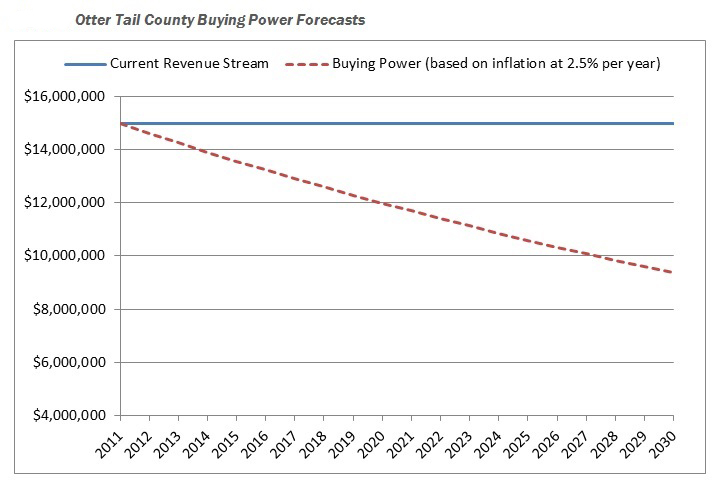
In rural Otter Tail County alone, the cost of road construction has climbed 10.5 percent per year for the past 10 years.

Meanwhile, there has been only one increase in funding — an 8.5-cent bump in the state gasoline tax “that was eaten up the moment it was enacted,” said County Engineer Rick West.

Otter Tail’s funding gap? An estimated $11 million in year 2011 alone.

With no change in sight, counties across the state are banding together in a research project through the Local Road Research Board to identify ways to reduce the size of their road systems and lower preservation costs.

Forced into a corner

The LRRB launched the study at the behest of counties who were considering turning some paved highways back to gravel just to get by — even though it would probably increase long-term maintenance costs.

In addition to providing expertise on that topic, consultants worked with a group of pilot counties to develop other strategies of stretching county road dollars further. These include: changing maintenance schedules; using different gravel road materials; transferring roads to city or township ownership; adopting different road performance measures; and raising local revenue.

“This project of how five different counties approach funding limitations and how to manage a system with constrained resources is one of the best that I have been a part of through the LRRB,” said Miller, who found the data critical to convincing her county board to pass a wheelage tax.

ottertail2

A new way of thinking

Although the ideas developed through the study aren’t entirely new, for a busy county engineer with few staff, the assistance to implement them has been very valuable.

“We’re practitioners — not researchers,” said Otter Tail’s Rick West. “It’s really forced us to look at our system in its entirety and from a long-range perspective. For us, that’s huge.”

The LRRB selected pilot counties (Dakota, Otter Tail, Freeborn, Stearns and Anoka) that reflect the diversity of the state. After researchers help them implement their chosen strategies, they will hold informational workshops for others throughout the state.

“Other counties with similar roadway preservation issues or management structures can follow these best practices,” said Michael Marti of SRF Consulting Group. “There are a lot of tools out there, there just needs to be more demonstration or training on each of these tools.”

Anoka County, for example, undertook a detailed analysis to determine which roads should become city-owned and which roads the county should assume.

The evaluation system used by Anoka, which examines travel data and other factors, could be adopted by other counties.
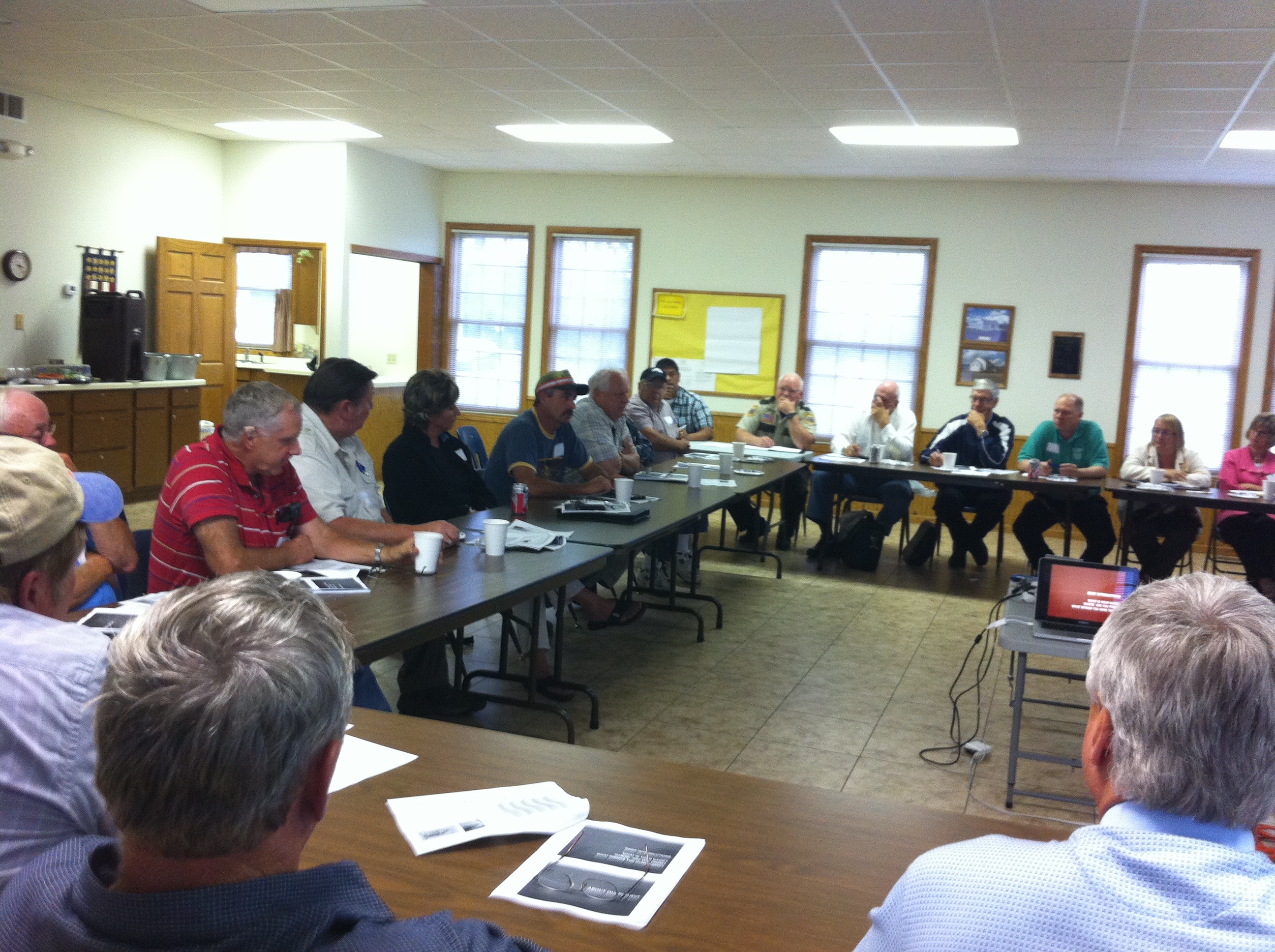
Public education

While some ways of changing the system of road maintenance may not be immediately popular, the community will get on board if they understand why, said Otter Tail County Board Chairman Wayne Johnson.

For instance, Otter Tail had to explain why it’s more cost-effective to sealcoat four-year-old roads than reconstruct beat-up, low-volume roads.

“That’s hard to get your arms around when it’s been the other way for 50 to 60 years,” Johnson said.

Community residents did, however, reject one possible strategy discussed at eight public outreach meetings: unpaving roads.

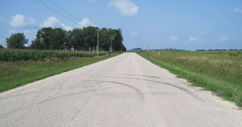
Otter Tail’s entire county road network is paved — a reflection of investments made back in the 1950s that have become somewhat of a community ethic for Ottertail’s 57,000 residents (a population that triples during the summer).

Tools used in the study enable counties to illustrate just how far behind they are in terms of maintenance and prioritize where to make improvements.

“Everyone wants roads to be maintained, but until the road system preservation study, nobody understood the magnitude of the funding gap between where we are and what we need to do to preserve the system,” said Johnson, who recently shared his county’s findings at the National Association of County Engineers conference.

The data is critical for the public to understand why a county might seek a local tax or different method of road maintenance.

“It’s far better to try to tell them what the problem is on the front end, rather than defend the decision on the back end,” Johnson said. “We’re after them to buy into something because it’s their roads and their money.”

Resources
  •  The project findings will be completed later this year and available on the LRRB’s website.