Category Archives: Bicycling

Three common questions about bike lanes, answered

If you’ve ever driven near a bike lane and not known what to do, you’re not alone.

A forthcoming video from the Local Road Research Board seeks to answer common questions about on-street bike lanes and help bicyclists and motorists better understand the rules. The video is due to be released this spring; in the meantime, we thought we’d give you a sneak preview by addressing three common misconceptions about bike lane rules and safety. 

1) Are bicyclists required to use a bike lane, when present?

No. Although bike lanes usually provide the smoothest, safest and most efficient method of transportation — for everybody — they are not required to use them. They are allowed to ride outside bike lanes to make turns or avoid debris, and they still have the option of using an adjacent trail where available.

2) Are vehicles allowed to enter bike lanes?

Yes, but only to park or turn onto a driveway or street. Motorists should treat bike lanes like any other lane of traffic and yield to approaching bicyclists, but they do have the right to enter bike lanes when turning.

3) Do bicyclists have to follow the same rules as motorists?

Yes. Bicycles are considered vehicles under Minnesota state law and have the same rights and responsibilities. Cyclists are required to obey stop signs and signal their turns, just like motorists.

A federal project funded 75 miles of new bike lanes in four communities, including Minneapolis.
A recent federal project funded 75 miles of new bike lanes in four communities, including the city of Minneapolis. Biking in these areas increased 50 percent; 7,700 fewer tons of carbon dioxide were emitted and gas consumption was reduced by 1.2 million gallons. (Source)

Watch for the LRRB’s new bike safety video on Crossroads this spring. In the meantime, check out MnDOT’s tips on bicycle safety.

Exploring Nice Ride job accessibility and station choice

Although bike share systems are becoming more popular across the United States, little is known about how people make decisions when integrating these systems into their daily travel.

In a study funded by CTS, researchers from the U of M’s civil engineering department investigated how people use the Nice Ride bike share system in Minneapolis and St. Paul. The researchers examined how Nice Ride affects accessibility to jobs and developed a model to predict station choice.

In the first part of the study, the researchers created maps showing accessibility to jobs by census block for both Nice Ride and walking—as well as the difference between the two—at time thresholds ranging from 5 to 55 minutes.

Overall, in blocks with both Nice Ride and walking job accessibility, Nice Ride provides access to 0.5 to 3.21 times as many jobs as walking.

By comparing Nice Ride to walking, the study demonstrated that walking can successfully be used as a baseline to show how a bike share system improves job accessibility. The results also pinpointed when and where Nice Ride had the strongest accessibility advantage over walking.

“This type of information can be used by bike share system planners to identify where new stations could be built to maximize their impact on job accessibility,” says grad student Jessica Schoner, a member of the research team.

In addition, the team developed a theoretical model for bike share station choice. The model considers users’ choice of a station based on their preference 
for the amount of time spent walking, deviation from the shortest path (the closest station may not be in the direct path of the person’s destination), and station amenities and neighborhood characteristics.

Findings show that people generally prefer to use stations that don’t require long detours to reach, but a station’s surroundings also play an important role. Results also indicate that commuters value shorter trips and tend to choose stations that minimize overall travel time.

According to Schoner, understanding people’s station preference can help provide guidance to planners that want to expand or optimize a bike share system.

Read the full article in the January issue of Catalyst.

New guidelines developed for counting bike, pedestrian traffic

Image
Manual field counts require more labor than automatic technologies, but they can collect deeper data about demographics and helmet use. Both forms of monitoring are necessary to give a complete picture of bicycle and pedestrian traffic in the state.

To prepare for a multimodal future, state agencies must be able to plan and engineer a transportation system for all modes of transportation, including bicycle and pedestrian traffic.

The Minnesota Bicycle and Pedestrian Counting Initiative was launched to develop consistent methods for monitoring non-motorized traffic across the state. Researchers developed guidelines for manual counts using state and national examples, and they also created methods for extrapolating annual traffic volumes from short-duration automated counts, for integration into MnDOT’s vehicular count database program.

The guidance developed for manual counts includes forms, training materials, public information for passers-by, links to smartphone applications that provide counting locations and spreadsheets for reporting results.

MnDOT hosted six workshops and a webinar to introduce local officials to the initiative and recruit participants for pilot field counts. Researchers then analyzed how these field counts could be used with existing automated counts to extrapolate daily or annual data.

MnDOT has installed some of the very first automated counting equipment on a state road — Central Avenue NE in Minneapolis (on the bike lane) and Highway 13 in Eagan (on a shoulder). As of 2012, six agencies in Minnesota counted non-motorized traffic (annual reports are available from the city of Minneapolis and Transit for Livable Communities), and even though comprehensive data is not yet available, Minnesota is a leader in this type of monitoring with more than 1,000 manual count locations and 32 automatic count sites.

Because of Minnesota’s experience, researchers collaborated with the National Cooperative Highway Research Program’s national Methodologies and Technologies for Collecting Pedestrian and Bicycle Volume Data research project, due for release in 2014, and contributed to the Federal Highway Administration’s effort to update its Traffic Monitoring Guide to include a chapter on non-motorized traffic.

Learn more:

Free webinar July 9 on best practices for bicycle trail crossings

Intersections between trails and roadways can be dangerous places for bicyclists and pedestrians. Next week, MnDOT Research Services is offering a free webinar on a forthcoming manual designed to help make trail crossings safer.

On Tuesday, July 9, from 1:00 p.m. to 2:30 p.m. (CDT), University of Wisconsin—Madison Professor David Noyce will be conducting a workshop on his forthcoming handbook, “Decision Tree for Identifying Alternative Trail Crossing Treatments.” The project, funded by MnDOT and the Local Road Research Board, aims to identify current engineering state-of-the-practice for trail crossings and provide guidance as to appropriate crossing designs and vehicular and bicycle right-of-way hierarchies.

You can click on the link below at the specified date and time to watch the webinar. No registration is required.

http://mndot.adobeconnect.com/trailcrossing/

CTS Research Conference videos and presentations now available

If you weren’t able to attend the CTS Research Conference, or, if you simply want to check out presentations from other sessions, the videos of the keynote and luncheon speeches, as well as PPTs from most of the concurrent sessions, are now available on the CTS website. You won’t want to miss Minnesota Department of Health Commissioner Ehlinger’s tuneful take on the links between health and transportation and Elizabeth Deakin’s view of new ways to get around.

Bicycle and pedestrian counting initiative monitors nonmotorized traffic in Minnesota

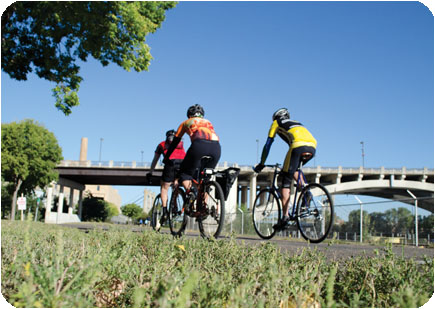
In a continuing effort to better understand nonmotorized traffic patterns in Minnesota, researchers from the Humphrey School of Public Affairs have partnered with the Minnesota Department of Transportation (MnDOT) to develop guidelines and analyze information collected in bicycle and pedestrian traffic counts throughout the state.Image

The research team, led by Professor Greg Lindsey, aims to develop consistent methods for monitoring and assessing bicycle and pedestrian traffic that can be used in both permanent, automated traffic counts and short-term manual counts. The goal is to provide evidence for decision making that Minnesota cities have historically lacked, Lindsey says. “We’ll have practical, useful information about bike and pedestrian traffic that can help local jurisdictions as they plan and invest in infrastructure,” he says.

As part of the 18-month project, the research team created a set of tools and methods for short-duration manual counts of nonmotorized traffic, held training workshops, and organized a statewide counting effort involving 43 Minnesota municipalities last fall. The overall response was positive, Lindsey says, and some communities are already using their collected data to submit grant proposals for projects related to nonmotorized traffic.

In addition, Lindsey and his team have examined traffic information from six permanent counters on Minneapolis trails. The continuous counts collected at these locations help the researchers understand traffic patterns and the factors that affect them, Lindsey says. For example, the team found that bike and pedestrian traffic vary by trail type, time of day, day of week, and season.

“Once we know the patterns at permanent sites, we can develop factors that help us expand short-term counts from other locations with similar conditions,” Lindsey says. The factors could be used to estimate anything from total daily traffic to annual traffic, as long as the short-term count location is similar to an existing model.

Based on the overall results of the study, the research team developed recommendations for MnDOT. These include continuing to coordinate statewide short-term field counts, demonstrating the feasibility of automated counting technologies, and beginning to integrate nonmotorized and vehicular traffic databases.

Based on these recommendations, MnDOT is moving forward with a new project that will collect more short- and long-duration counts throughout Minnesota, says Lisa Austin, ABC Ramps coordinator at MnDOT. The next phase of work aims to collect counts for pedestrians on sidewalks, bicyclists on shoulders and in bike lanes, and pedestrians and bicyclists on multiuse trails. MnDOT plans to install more permanent, automated counters in suburban and midsize cities and to conduct additional manual counts in smaller cities around the state, Austin says.

“We’re really excited that this bike and pedestrian counting project is moving into wider implementation,” Austin says. “This next phase will help us see which automated counting technologies work well and make recommendations for moving forward on a broader scale.”

Reprinted from the CTS Catalyst, May 2013.

U of M transportation research highlights video

U of M transportation research highlights during 2012-2013 include a smartphone app for visually impaired pedestrians, pedestrian and bicyclist safety in roundabouts, methods for counting bike and pedestrian traffic on trails, and a filter that takes phosphorous out of storm water.