

Manufacturers are developing vehicles that can “talk” to each other. “Connected vehicles” will be able to convey their position, speed and acceleration. Sending this information to other vehicles and relevant infrastructure is expected to enhance highway safety, but it also may help transportation agencies better manage traffic.
Continue reading MnDOT Prepares to Use Future Vehicle-to-Vehicle MessagingTag Archives: traffic management

New System Measures Travel-Time Reliability to Reduce Traffic Delays
Researchers for the Minnesota Department of Transportation have developed a new travel-time reliability measurement system that automates the process of gathering and managing data from multiple sources, including traffic, weather and accident databases, to generate travel-time reliability measures and reports for the metropolitan freeway network.
What Was the Need?
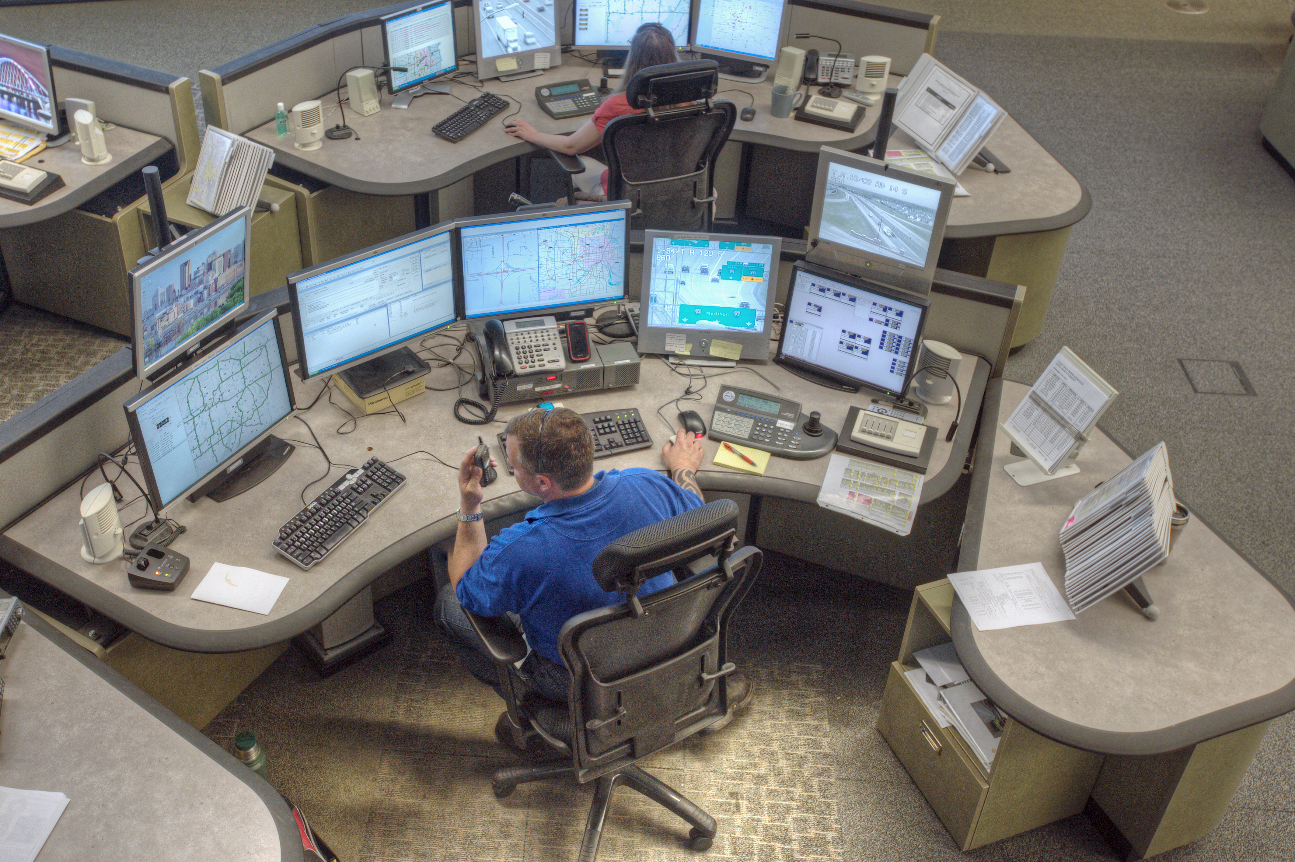
Improving traffic efficiency has become a key goal of traffic operations managers. In heavy traffic periods, MnDOT’s Regional Transportation Management Center (RTMC) coordinates with Minnesota State Patrol and MnDOT Maintenance Services to detect and quickly respond to freeway incidents in the Twin Cities. The RTMC works with the Freeway Incident Response Safety Team to assist and remove stranded vehicles using MnDOT emergency road service trucks. RTMC also updates real-time road condition information on its 511 traveler information system.
bad weather and road construction that cause freeway congestion.
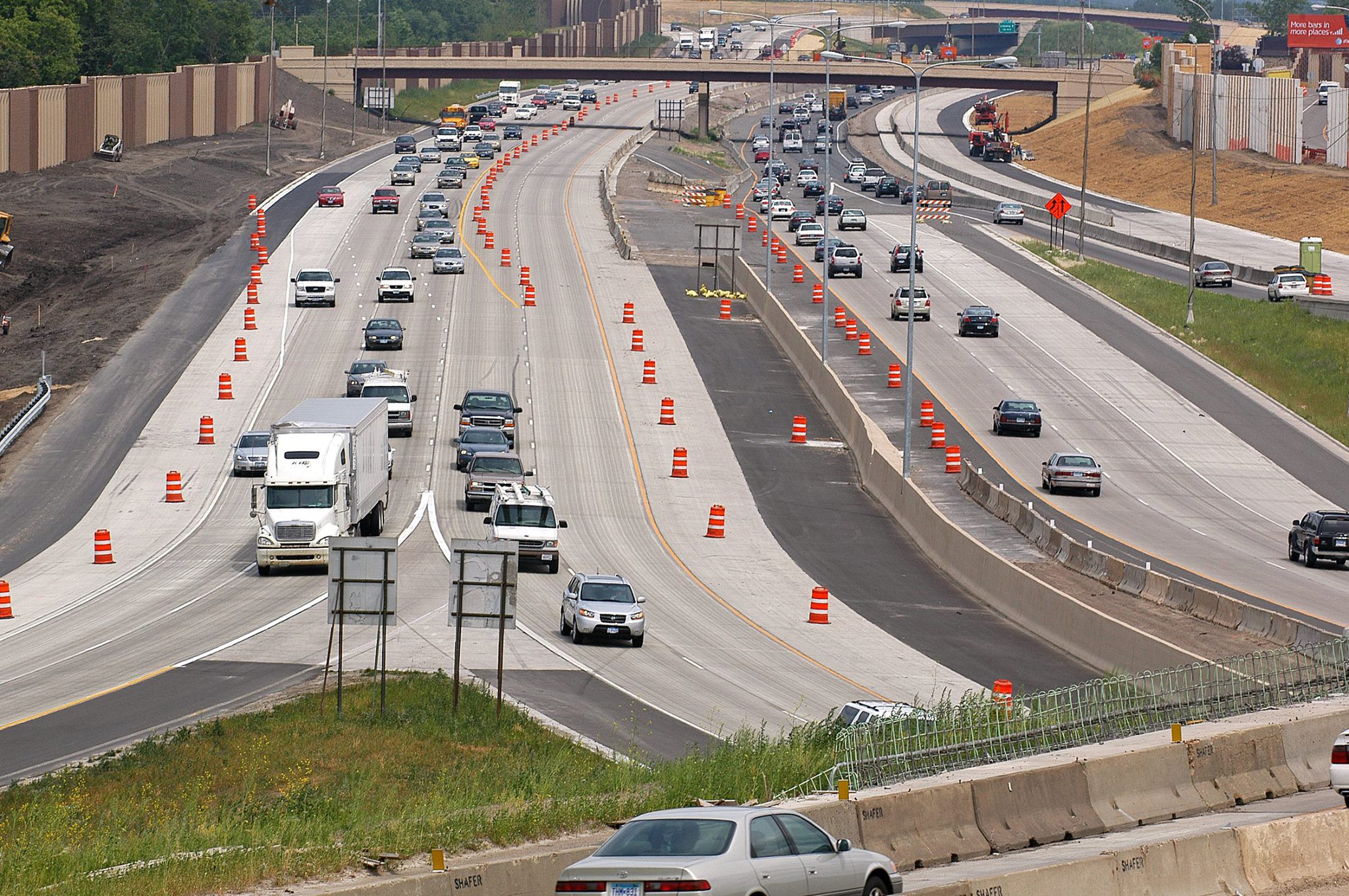
MnDOT and RTMC measure delay and congestion on the metropolitan freeway system, reporting the data in annual reports like the 2017 Congestion Report. While useful, this data offers little predictive value on its own. MnDOT’s metropolitan freeway system features 4,000 loop detectors that transmit traffic data every 30 seconds; this data informs the congestion and delay reports.
Correlating this data with locations on the freeway system and various operating conditions, such as weather and traffic incidents, is time- consuming. But the data could be used to systematically evaluate traffic delays and develop strategies to mitigate congestion.
What Was Our Goal?
In this project, investigators sought to develop a system for automatically accessing weather, crash and traffic data to assess travel-time reliability—the variability in travel times for any given route. Travel-time reliability measures are becoming the key indicators for transportation system operations and management.
What Did We Implement?
Investigators developed a new travel-time reliability measurement system (TTRMS) that integrates different types of data (such as weather, traffic, incident, work zone and special event) acquired from multiple sources and automatically produces various types of travel-time reliability measures for selected corridors following user-specified operating conditions and time periods.
“Travel-time reliability is another way of looking at congestion and at strategies for making it more tolerable. It used to take several hours, even days, to process travel-time reliability data. The TTRMS processes it in minutes,” said Brian Kary, Director, MnDOT Regional Transportation Management Center.
How Did We Do It?
Investigators began by developing a detailed design of the TTRMS architecture—its modules, their functions and their interactions. The team then developed a work-zone data input module, where detailed lane configurations of a given work zone can be specified.
Developers designed a travel-time reliability calculation module as the core of the new system that can automatically access MnDOT’s traffic data archive, its incident database and the National Oceanic and Atmospheric Administration’s weather database. It can also accept a set of input data for work zones, such as lane-closure periods and locations. The reliability calculation module was then integrated with user interfaces and reporting modules. Finally the integrated system was tested with the real data gathered in 2012 and 2013 from Interstates 35E and 35W, U.S. Highway 169 and State Highway 100.
What Was the Impact?
The system generated accurate travel-time reliability measures for the test periods and given operating conditions. In particular, the output measures were automatically generated in both table and graphical formats, thus saving traffic engineers significant amount of time and effort.
The TTRMS includes map-based interfaces, which provide administrators and general users with substantial flexibility in defining corridors, specifying operating conditions and selecting types of measures depending on the purposes of applications.
To test the new system’s performance, the research team used the TTRMS to evaluate traffic strategies deployed for the February 2018 Super Bowl in Minneapolis. Two weeks before the event, reliability was low for the freeway system serving the football stadium. During the week of the Super Bowl, MnDOT and the Department of Public Safety aggressively managed traffic incidents to keep traffic moving, and reliability rose substantially despite the increase in tourist traffic. In the days immediately after the Super Bowl, operational strategies returned to normal levels, and reliability fell to previous levels. Results suggest that aggressive incident management during this exceptionally high-volume regional event enhanced traffic efficiency.
What’s Next?
Further enhancements to the TTRMS should include automating inputs for work zone data, such as lane closures, changes in work zone locations and time periods. Future research could help traffic operations prioritize resources and develop short-term and long-term freeway improvements, including studies of bottlenecks and the freeway network’s vulnerability and resilience for natural events and large-scale incidents.
This post pertains to Report 2018-28, “Development of a Travel-Time Reliability Measurement System,” published September 2018.

Building More Accurate Traffic Modeling for Twin Cities Construction Projects
MnDOT is exploring different software options for developing a “mesoscopic dynamic traffic model” that can more accurately predict road construction impacts than current macroscopic models like the Twin Cities Regional Travel Demand Forecasting Model.
“Dynamic traffic assignment is an emerging model type, and there are a lot of software platforms with different methodologies. MnDOT was interested in reviewing their pros
and cons,” said Jim Henricksen, Traffic Forecaster, MnDOT Metro District, who helped lead a recent research project that analyzed different software packages.
“A team maintains the Twin Cities Regional Travel Demand Forecasting Model. Any mesoscopic model would require a similar maintenance effort to keep the model from becoming obsolete as construction adds new lanes,” said John Hourdos, Director, Minnesota Traffic Observatory, University of Minnesota, and principal investigator for the study.
What Was the Need?
Traffic modeling is a valuable tool used in transportation planning to predict the impacts of new construction or maintenance projects. MnDOT currently has modeling tools available in two scales: macroscopic and microscopic. Macroscopic-scale planning level tools such as the Twin Cities Regional Travel Demand Forecasting Model predict driver route choice and the number of drivers that will travel on a given road at a given time. Microscopic-scale traffic simulation, on the other hand, models driver behaviors such as gap acceptance or acceleration rates. MnDOT uses microscopic-scale simulation to plan capacity-increasing projects, but the tool is only feasible on the corridor level because generating the simulation requires a large amount of data and computing power.
To bridge these two scales, MnDOT is developing a mesoscopic-scale dynamic traffic assignment (DTA) model for the Twin Cities. This model falls between microscopic- and macroscopic-scale modeling in scope and complexity. It simulates the movement of individual vehicles based on traffic flow equations rather than driving rules, which requires less detail and computing time than a microscopic simulation and can be used over a wider area. MnDOT will use this model for applications such as staging construction seasons to minimize the disruption caused by multiple large projects, or coordinating traffic modeling across the road networks operated by MnDOT, counties and cities.
To assist in developing this system, MnDOT needed information about the capabilities of available modeling software packages in addition to the needs, desires and restrictions of the agencies and consultants who will be using the model.
What Was Our Goal?
The goal of this project was to better understand the capabilities of commercially avail-able modeling software packages to address MnDOT’s modeling and simulation needs.
What Did We Do?
Investigators interviewed stakeholders about their understanding of and need for mesoscopic traffic simulation and DTA. Stakeholders included individuals who have used or requested data from the Twin Cities Regional Travel Demand Forecasting Model maintained by the Metropolitan Council. Investigators also reviewed four case studies of mesoscopic DTA models used in Manhattan; San Francisco; Detroit; and Jacksonville, Florida.
To supplement the findings from the interviews and case studies, investigators conducted a comprehensive review of the claimed capabilities of six commercially avail-able traffic simulation software packages: TransModeler, Aimsun, DynusT/DynuStudio, Dynameq, Cube Avenue and Vissim. Investigators didn’t test the software, but instead reviewed manufacturers’ documentation and literature to identify limitations of their methods and whether those methods are applicable to MnDOT’s needs.
What Did We Learn?
To compare the capabilities of the various simulation software packages, investigators created a matrix that included comprehensive notations about a software package’s claimed features that may not fully meet MnDOT’s simulation needs. For example, some software packages claim to model actuated signals, but they create models based on Highway Capacity Manual assumptions rather than real-world conditions.
DynusT is the most commonly used simulation program, possibly because it is open-source and the easiest software to use, although it requires DynuStudio, a commercial graphical user interface and data management system. DynusT also has some limitations, such as not considering the individual lanes in each roadway segment, which would limit its effectiveness in modeling roads where individual lanes have imbalanced densities.
Most interviewees had only limited experience with mesoscopic modeling. Incorporating traffic signals in a simulation network is a significant challenge, according to interviewees, because currently a database of signal timings isn’t available.
While all four of the DTA case studies reviewed required more data, calibration and validation than older models, each of the developers reported that these challenges had been mitigated, and the models created could answer complex questions that previous models couldn’t.
What’s Next?
Traffic simulation and modeling is a fast-developing field, particularly mesoscopic-scale modeling. Each of the software packages reviewed in this project has had at least two new versions in the past 18 months, and while their modeling approaches are fundamental to the software in some cases, in other cases capabilities will be added or improved as software develops.
The foundation of a mesoscopic model for the Twin Cities has been built and tested in Transmodeler (with significant pro bono work from the software developer). However, MnDOT has also used its existing DynusT model for several projects beyond its initial purpose, and the agency will use the information gathered in this project to determine which approach is more practical for MnDOT and its consultants based on cost, capabilities and data availability. Transmodeler is generally more powerful, but it will also incur greater costs, particularly since every consultant would need to acquire its own copy of the software.
This Technical Summary pertains to Report 2017-10, “Framework and Guidelines for the Development of a Twin Cities Mesoscopic DTA Model,” published April 2017.

Infrared Sensing Not Yet Suitable for HOV/HOT Lane Enforcement
Could the same infrared technology that’s used by security firms to detect trespassers be used to spot carpool lane violators? Not yet, says new research sponsored by MnDOT, which shows that to consistently detect passengers through windshield glass, the system would require a laser that might harm people’s eyes.
“Some vendors have proposed significant investments in sensing technology for HOV/HOT lane enforcement,” said Nikos Papanikolopoulos, Professor, University of Minnesota Department of Computer Science and Engineering. “This research demonstrated that it’s not safe, so the tests saved a lot of money and protected the well-being of drivers.”
“Development is still continuing in the industry, so we will cautiously evaluate sensing technologies as they come along,” said Brian Kary, MnDOT Freeway Operations Engineer. “This research gave us a solid base of knowledge about what we’ll be looking for and what we need to avoid.”
Papanikolopoulos served as the research project’s principal investigator, and Kary served as technical liaison.
What Was the Need?
High-occupancy vehicle/high-occupancy toll (HOV/HOT) lanes have gained popularity in recent years as a way to address highway congestion in urban areas. However, enforcing the provisions that either prohibit or charge a toll to single-occupant vehicles in HOV/HOT lanes can be challenging. Currently, enforcement is handled by law enforcement officers, but this is a labor-intensive process that can’t catch every violator and can create a traffic safety hazard.
Obtaining technology to assist officers with enforcement is a goal for MnDOT and many other agencies that operate HOV/HOT lanes, and several manufacturers are working to develop enforcement cameras. But this has proven to be a difficult task. Window tinting and glare from sun-light can thwart common sensing technologies like video cameras and microwave radar (commonly used in speed limit enforcement). Previous research using near-infrared sensors has shown promise, but none has produced completely successful results.
This study tested Honeywell’s Tri-Band Infrared (TBI) sensor, which was originally used to automatically detect intrusions at high-security entrance gates. In addition to a black-and-white camera and an illuminator, the TBI has two co-registered near-infrared cameras. The system takes advantage of the fact that human skin reflects infrared light much more effectively at wavelengths below 1400 nanometers. The TBI’s infrared cameras are sensitive to different wavelengths, one below and one above that threshold, and fusing the images from these two cameras makes silhouettes of faces more prominent.
What Was Our Goal?
The goal of this project was to evaluate whether the TBI sensor is suitable for HOV/HOT lane enforcement applications.
What Did We Do?
Investigators first tested the sensor outdoors on oncoming vehicles with known positions that ranged from 25 to 140 feet from the sensor. These tests demonstrated that the sensor had limited ability to penetrate modern vehicle glass, possibly because the system’s illuminator component was ineffective.
Investigators purchased two infrared lasers providing illumination at wavelengths of 1064 nanometers and 1550 nanometers to increase the TBI sensor’s ability to detect people through windshield glass. Then they conducted indoor tests to compare the impact of these illuminators with that of the original illuminator: With a test subject holding front passenger windows from several manufacturers in front of his face, the lasers were aimed at the subject while the TBI attempted to detect him.
Finally, investigators conducted outdoor tests using the TBI to detect people in three test vehicles from the front and the side under both sunny and cloudy conditions. These tests were conducted both without illumination and with the aid of high-power incandescent spotlights modified to output infrared light, and with the sensor at several different distances from the vehicles.
What Did We Learn?
The indoor tests demonstrated that when aided by supplementary illuminating lasers, the TBI sensor was capable of detecting humans through commonly manufactured vehicle window glass.
However, to achieve successful results, these lasers must operate with high power in a narrow range of wavelengths. Despite operating outside the visible spectrum, they can damage human eyes when operating at the necessary power level to enable effective detection through glass. While investigators conducted this project’s indoor tests with adequate protection, there is currently no way to ensure safe usage of the lasers in real-world applications.
In the second outdoor tests, the unilluminated sensor successfully detected a passenger only once out of 24 attempts. With illumination, the sensor successfully detected people in some cases, particularly when there was no direct sunlight or reflective glare. One surprising discovery was that high-band (above 1400 nanometers) infrared light penetrated window glass more consistently, even though the low band had more spectral energy.
What’s Next?
Due to safety concerns about using the illuminating laser at a high enough power to penetrate all windshield glass, the system is not suitable for HOV/HOT lane enforcement. There is some indication that sensor technology has improved since the release of the TBI, and MnDOT will continue to monitor industry developments, but it has no current plans to pursue using infrared cameras for this application.
The technology may be suitable for other sensing applications that do not require high-power illumination. For example, the sensors might be useful in systems that provide information to drivers in real time, such as applications that identify available truck parking spaces in rest areas or that alert drivers to the presence of workers in work zones.
—
This Technical Summary pertains to Report 2017-05, “Sensing for HOV/HOT Lanes Enforcement,” published February 2017. The full report can be accessed at mndot.gov/research/reports/2017/201705.pdf.

Videos trace progress in traffic operations, pavement design
Last month, CTS debuted two videos about the many contributions U of M researchers have made—and are still making—in traffic operations and pavement design.
The videos are one of the ways CTS is marking 30 years of transportation innovation. Our goal is to show how research progresses over time—from curiosity to discovery to innovation. The videos also show how U of M research meets the practical needs of Minnesotans in the Twin Cities metro and throughout the state.
The first video focuses on improving traffic operations, a research focus since our earliest days. Professor Emeritus Panos Michalopoulos invented Autoscope® technology to help transportation agencies capture video images of traffic and analyze the information, enabling better traffic management. Autoscope was commercialized in 1991, and the technology has been incorporated into products sold and used worldwide.
Current traffic operations research builds on this strong foundation. For example, the U’s Minnesota Traffic Observatory, directed by John Hourdos, develops data collection tools such as the Beholder camera system. The system is deployed on high-rise rooftops overlooking a stretch of I-94 in Minneapolis—an area with the highest crash frequency in Minnesota—to help the Minnesota Department of Transportation reduce congestion and improve safety.
The second video showcases U of M research on pavement design. Developing pavements that can stand up to Minnesota’s harsh climate is a continuing priority for researchers, whose work has led to new methods, tools, and specifications to extend pavement life. The video also looks at how research teams are pushing the envelope with use of materials such as taconite waste and graphene nano-platelets for pavement applications.
