As bridge infrastructure in Minnesota and across the country ages, maintaining and preserving the existing bridge network becomes increasingly important—and increasingly challenging. In Minnesota alone, 25 percent of bridge-deck area is more than 50 years old, and the number of bridges rated in “fair” condition has recently overtaken the number rated in “good” condition.
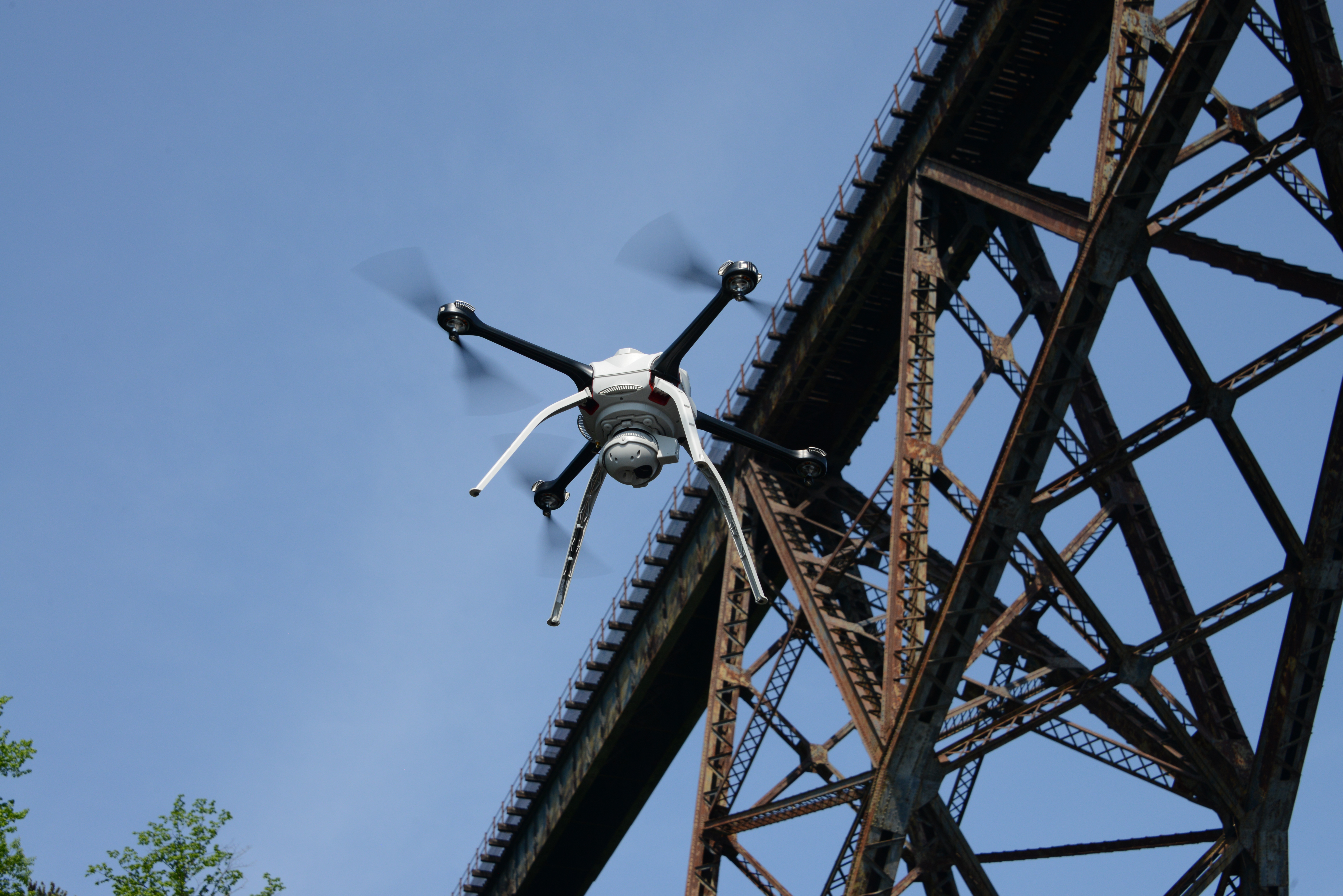
Using drones to inspect bridges allows MnDOT to collect very high quality data while exposing fewer inspectors to far less risk and reducing inconvenience to the public. A new fleet of UAS will be used to conduct inspections statewide.
MnDOT recently entered into a contract with Collins Engineers Inc. to complete a third phase of research testing drones for bridge inspections, with a new focus on confined spaces.
This Phase 3 project is titled “Improving Quality of Bridge Inspections Using Unmanned Aircraft Systems.” Jennifer Wells, MnDOT maintenance bridge engineer, will serve as the project’s technical liaison. Barritt Lovelace, regional manager for Collins Engineering, will serve as principal investigator.
“Phase 3 will allow us to utilize a new drone specific to confined space inspections,” Wells said. “This new drone is meant to reach places the prior drones could not, which will supplement our efforts nicely. Also, Phase 3 will include more bridge inspections in order to get a more comprehensive feel for cost and time savings.”
The increasing costs of bridge inspections are a concern for MnDOT. The use of unmanned aircraft systems (UAS) has been shown to reduce costs, improve the quality of bridge inspections, and increase safety. The UAS can deploy a wide range of imaging technologies including high definition still, video, and infrared sensors, and data can be analyzed using 3D imaging software.
MnDOT completed a small research project in 2015 to study the effectiveness of UAS technology applied to bridge safety inspections. The project team inspected four bridges at various locations throughout Minnesota and evaluated UAS’ effectiveness in improving inspection quality and inspector safety based on field results.
A second research effort demonstrated UAS imaging on the Blatnik Bridge and investigated UAS use for infrared deck surveys. Additionally, a best practices document was created to identify bridges that are best suited for UAS inspection.
It is the goal, based on this next phase of research, to implement a statewide UAS bridge inspection plan, which will identify overall cost effectiveness, improvements in quality and safety, and future funding sources for both state and local bridges.
Collins Engineering will also investigate a collision tolerant drone — the Flyability Elios — for confined space inspections.
As part of the Phase 3 project, Collins Engineering will:
Review current Federal Aviation (FAA) rules, technical literature, owners and industry experiences, and ongoing UAS research.
Develop bridge inspection list based on Phase II research regarding best practices. Approximately 20-25 bridges will be inspected under this contract depending on location and size.
Develop a field work plan for the bridge inspection list. If approvals for these bridges cannot be obtained, suitable alternatives will be chosen. This field work plan will address safety concerns, FAA, and other agency requirements.
Establish a work schedule and deliverable submission schedule.
Establish methods of access and schedule equipment.
Receive training on the Flyability collision tolerant drone for use in the study.
Perform field work at the selected bridges to collect imagery and evaluate the technology to accomplish the project goals.
Inspect known deficiencies identified during previous inspections with the use of the UAS to evaluate the ability to identify deficiencies using photos and video.
Enter bridge inspection data in Minnesota’s Structure Information Management System (SIMS) providing element condition ratings, photos, videos, etc. based on UAS imagery and information.
Prepare a draft report to document project activities, findings and recommendations.
The Phase 3 project is scheduled to be complete by July 2018.
MnDOT’s efforts to study whether drones can help bridge inspectors are progressing, and the second phase project has been completed. (Meanwhile, a third project has just begun.)
Phase 1 of this research project demonstrated that drones can reduce safety risks and inconvenience to bridge inspectors and the traveling public. Phase 2 shows that new drones, designed with vertical and horizontal camera and sensor capabilities for structure inspections, give bridge inspectors safe access to under-deck areas that were previously difficult or impossible to reach. The new drones cost even less than the unit tested in Phase 1.
“Using a drone rather than snoopers for bridge inspection can save significant time and cost. The FHWA approves of this use as well. It’s another tool for inspectors to employ,” said Jennifer Wells, Principal Engineer on Mobility, MnDOT Office of Bridges and Structures.
“We were one of the first transportation agencies and contractors to test and use this new technology for bridge inspections. Drones let bridge inspectors collect more data and collect it more safely and efficiently,” said Barritt Lovelace, Regional Manager, Collins Engineers, Inc.
What Was the Need?
MnDOT and local bridge owners have 600 bridge inspectors who monitor more than 20,000 bridges in Minnesota. Each bridge must be inspected once every 24 months. Bridges in poor condition and those considered fracture-critical (where failure of a single component could cause collapse) must be inspected every 12 months. Large bridges can take weeks to fully inspect and often require inspectors to dangle from ropes or stand in buckets on the end of “snoopers,” cranes that reach from the bridge deck to below-deck level to put inspectors within sight of under-deck elements.
Snoopers are expensive and require traffic lane closures, presenting safety risks to the traveling public and inspectors. MnDOT established in a Phase 1 study that unmanned aircraft systems (UAS) significantly augment inspection findings with infrared and imaging data while reducing safety risks to inspectors and the public. The project earned a 2016 Minnesota State Government Innovation Award as well as awards and recognition from such groups as the American Public Works Association.
UAS designed specifically for structure inspections were unavailable during Phase 1. The UAS used in that phase had key operational limitations, including the inability to proceed when concrete and steel bridge components blocked Global Positioning System (GPS) signals. When that happened, the drone simply returned to base automatically.
What Was Our Goal?
In Phase 2, MnDOT wanted to test the use of an upgraded UAS to examine larger and more challenging bridges. The new UAS, which was specially designed for structure inspections, featured more robust imaging and infrared data-gathering capabilities, and was more flexible to control. Its operational capabilities also were not diminished by the loss of GPS signals. Results from UAS inspections and traditional bridge inspection methods would be compared for quality and cost-effectiveness.
What Did We Do?
Investigators selected a prototype senseFly albris UAS to inspect four bridges:
The Blatnik Bridge over the St. Louis River between Duluth, Minnesota, and Superior, Wisconsin, a 7,980-foot-long steel through-arch bridge with steel deck trusses.
A 362-foot-long two-span steel high truss bridge over the Red River in Nielsville, Minnesota.
A 263-foot-long corrugated steel culvert in St. Paul.
The Stillwater Lift Bridge, a 10-span structure over the St. Croix River with six steel through-truss spans and one movable span.
For each bridge or structure, researchers prepared detailed safety and inspection plans to identify and mitigate potential hazards, inspection needs and Federal Aviation Administration (FAA) requirements. Researchers conducted and evaluated UAS and standard inspection methods for each inspection site, analyzing results in terms of access technique, data collection and usefulness for interim and special inspections.
What Did We Learn?
The senseFly albris UAS offered a clear operational upgrade over the Phase 1 unit. It can operate without GPS; the camera lens can turn up and down at 90-degree angles; and protective shrouds and ultrasonic sensors prevent the propellers from striking bridge elements.
Thermal image of a bridge deck taken by a drone.
For some inspection functions, lane closures can be curtailed or eliminated altogether. The drone worked well in the high, confined spaces of the Blatnik Bridge and should provide under-deck inspection details otherwise unavailable or too costly for any tall bridge in the MnDOT system. This UAS identifies and measures clearances, rope access anchor points and other pre-inspection conditions for planning large-scale or emergency inspections. Photogrammetry software can be used with the UAS to develop three-dimensional models of bridges and bridge sites. Using infrared thermal sensors, the UAS can detect delamination of concrete while flying adjacent to lanes of traffic. For smaller, confined spaces on bridges and culverts, the senseFly albris may not be ideal. Despite its protective shrouds, it is not as collision-tolerant as needed for very tight spaces.
Currently no UAS replicates hands-on inspection functions like cleaning, sounding, measuring and tactile testing. But the UAS is an additional tool that provides conventional and improved data safely. The FAA and the MnDOT Office of Aeronautics no longer require private pilot certification for drone operators. A new, streamlined certification and licensing procedure makes drone use more practical.
Costs were significantly lower with UAS inspections than with conventional approaches. Conventional inspection of the Blatnik Bridge would have required four snoopers, an 80-foot lift and eight days of inspection, at a cost of about $59,000 (without the cost of mobilizing equipment and traveling). The UAS Blatnik Bridge inspection would contract as a five-day, $20,000 project.
What’s Next?
Phase 3, which began in the summer of 2017, uses the senseFly albris and the Flyability Elios, a collision-tolerant drone more suited to confined spaces such as box girders or culverts. During this phase, researchers will identify which situations are best suited for drone use, what parameters should govern drone use in bridge inspections, and how UAS can be integrated into standard inspection operations at a county and district level.
In the video, Jennifer Zink, MnDOT state bridge inspection engineer, explains the project, along with Tara Kalar, MnDOT associate legal counsel; Cassandra Isackson, director of MnDOT Aeronautics; and Bruce Holdhusen, MnDOT Research program engineer.
The initial drone project drew significant media coverage and a lot of attention from other state departments of transportation from all over the country.
A second phase of the project was approved year and is currently underway. A third phase is already in the planning stages.
As the flying electronic devices became easier to use and less expensive, all sorts of individuals, businesses, nonprofit groups and government organizations – including the Minnesota Department of Transportation (MnDOT) – are exploring ways to use them.
This past summer, MnDOT began researching how to employ these unmanned aerial vehicles, or UAVs, to someday help inspect the state’s many bridges.
“That day may still be far off, but our initial project was an encouraging first step,” said Jennifer Zink, MnDOT bridge inspection engineer. “Phase 2 of the project will better provide details as to methods, criteria and cost effectiveness for how to apply drone technology best to bridge inspection.”
Project goal
Using drones could help minimize risks associated with current bridge inspection methods, which include rope systems and special inspection vehicles. (Photo by D.R. Gonzalez, MnDOT)
The research team tested drones this past summer while inspecting four Minnesota bridges (in Chisago County, Olmsted County, Morrison County and near Stillwater) specifically selected for the study after an extensive evaluation and FAA approval.
Zink and her colleagues wanted to investigate whether drones could help MnDOT decrease the rising costs of bridge inspections and collect more detailed information. Drones could also minimize the risks for bridge inspectors, who currently use rope systems and special inspection vehicles to access hard-to-reach areas. Using a drone to gather images could keep inspectors out of harm’s way and inspection vehicles out of active traffic lanes.
“The goal of the project was to study the effectiveness and possibilities of using UAVs to aid in bridge inspection work, typically in gathering images without the use of an under-bridge inspection vehicle and in areas where access is difficult or not safe for an inspector,” Zink said. “There is no substantive guidance in existence for this application of this evolving technology. This initial effort was to gain a better understanding of potential capabilities, processes and planning best practices.”
FAA approval
Before simply launching drones and collecting bridge data, the research team reviewed current FAA rules and applied for the necessary exemptions. Approval was granted, but only for the use of an Aeryon Skyranger drone. Even though exemptions for several models were submitted to the FAA, none were approved in time for the field study.
Once in the air, the drone suitably performed a variety of inspection functions that didn’t require a hands-on physical inspection. Researchers tested the drone’s ability to gather high-quality still images and video footage of bridges. They also collected data from infrared cameras. In addition, the drone provided the ability to capture data needed to construct maps of bridge areas and 3D models of bridge elements.
“The images, including infrared images to detect deck trouble spots, obtained from the drone correlate to the findings in the bridge inspection reports for specific bridge elements,” Zink said.
Missing from the research were images of the underside of bridges. The drone model used in the study wasn’t able to shoot images upward from beneath a bridge, and inspectors identified that as a key feature along with the ability to operate without a GPS signal.
“The drone we used in this project was not completely ideal for an entire gathering of imagery for all bridge inspection elements as it was limited to GPS signal capability,” Zink said. “However, it did give us an idea of what a drone could provide, what the limitations were, and what features we would like to see on newly available UAV models. Unfortunately, our hands were tied with obtaining FAA exemptions only for the particular model used in this project within the funding timeframe.”
Conclusions and recommendations
The project’s final report listed several conclusions, including that drones can be used safely during bridge inspections and that risk to both the inspectors and public is minimal.
“Due to the successful outcome of the initial project, we have a better understanding of the drone capabilities we would like to use during an actual scheduled bridge inspection,” Zink said. “The drone that will be used in Phase 2 is specifically designed for inspection of structures. Several goals exist for the Phase 2 research project, and if we can accomplish them, they will decrease MnDOT’s costs and increase bridge inspection abilities. It could improve inspection data collection for local agencies as well.”
The researchers recently were notified that they received funding for Phase 2 of their project, which is expected to start later this fall.