

As hauling practices change for waste collection, mining and other industries, local transportation agencies are receiving more permit requests for oversize or overweight trucks. These larger vehicles can have significantly greater impacts on pavements than passenger vehicles.
Continue reading New Project: Best Practice for Oversized/Overweight VehiclesCategory Archives: Research
General research posts.

New Project: Amount of Bituminous Surface Lost Each Year
Approximately 62,000 miles of Minnesota’s roads are bituminous, or asphalt, surfaces. Bituminous roads are cost-effective and offer improved ride quality and safety.
Continue reading New Project: Amount of Bituminous Surface Lost Each Year
New Project: User Understanding of Pedestrian Hybrid Beacon Operation
Pedestrian hybrid beacons (PHBs) are one tool to help pedestrians safely cross roads. PHBs provide red-signal control for vehicular traffic when needed at lower installation costs and reduced traffic delays than full traffic signals.
Continue reading New Project: User Understanding of Pedestrian Hybrid Beacon Operation
Clear Roads’ National Survey Compiles Tenth Year of Winter Maintenance Data

Clear Roads has just published its tenth Annual Survey of State Winter Maintenance Data, which compiles winter resources, material and cost data from 41 states for the 2023-2024 winter season. The spreadsheet includes all submitted data, as well as calculated statistics, winter severity index data, and a United States map that displays many of these metrics. The spreadsheet also includes data from the previous nine surveys (winters 2014-2015 through 2022-2023) and displays averages and changes across winter periods.
Reprinted from Clear Roads, February 5, 2025

Administrative Rules and Structures of Speed Safety Camera Systems
Speed Safety Cameras (SSCs) detect the speed of vehicles through the use of radar technology or detectors that are embedded in the surface of the roadway, and associate those readings with a photograph or video of the vehicle. They can be deployed as fixed units (a stationary camera targeting a specific location), point-to-point units (multiple cameras that capture average speed over a set distance) or mobile (a portable camera positioned in a trailer or vehicle). The results are then “read” by trained analysts in a data center, who may or may not be members of law enforcement. Speeding tickets are then issued on the basis of this technology. The question facing the Minnesota Legislature in 2024 was, is this needed? And what are the best practices for implementing it?
Continue reading Administrative Rules and Structures of Speed Safety Camera Systems
Mobile lockers, equitable freight planning, and cargo e-bikes will play roles in urban freight
Reprinted from CTS News, January 14, 2025
Freight transportation is evolving rapidly, and its future success will require managing increased residential demand, planning for equity, and incorporating micro-delivery options such as cargo e-bikes. At the 2024 CTS Transportation Research Conference, three experts shared their knowledge of these trending topics in a session focused on the future of urban freight.
In response to the increasing demand for residential package delivery spurred by the shift towards online shopping, U of M Department of Industrial and Systems Engineering PhD student Can Yin shared her research on mobile parcel locker scheduling. Yin explained that in the growing ecommerce market, last-mile delivery is the most expensive and time consuming. While door delivery is commonly used, it can be unsecure and inconvenient for customers.
“Parcel lockers are an alternative, but they come with the disadvantages of limited locations, expensive fixed cost, and the inability to adapt to varying demand,” Yin said.
A newer, more flexible alternative is the use of mobile, vehicle-based parcel lockers, which offer greater flexibility, higher accessibility, and lower fixed costs—particularly if autonomous vehicles eliminate the need for driver salaries. However, mobile parcel lockers also create challenges for e-commerce businesses such as estimating demand and customer choices.
To address these challenges, Yin’s research team developed a mobile parcel locker demand-estimation model. Additionally, the researchers found that compared with stationary lockers, mobile lockers offer a better value and demand fulfillment.
Another challenge surrounding the rapid growth of e-commerce and urban freight is racial equity in urban freight planning. In his presentation, University of Washington Urban Freight Lab researcher Travis Fried explained how his research is seeking to better understand these inequities and create a framework for mitigating them.
The past and present systems that perpetuate the segregation of people and neighborhoods have been well documented. However, Fried said there is little research exploring how these patterns play out in freight planning and their impacts on air quality, health, and road safety for people of color. Fried’s research looked at high-volume traffic exposure and found that low-income populations of color were disproportionately exposed to e-commerce traffic.
“By our most conservative estimate, BIPOC [Black, Indigenous, and people of color] populations were exposed to 35 percent more traffic related to last-mile home delivery on average, despite ordering less than half as many packages as white populations,” Fried said. That’s because delivery facilities and highways are disproportionately located near historically marginalized neighborhoods, he explained.
In light of this finding, Fried emphasized the importance of including equity considerations when prioritizing urban freight strategies. “Solutions focused on the upper end of the distribution chain have outsized benefits for marginalized communities, so we need to consider that in our cost-benefit evaluations and engagement strategies,” he added.
Using cargo e-bikes for last-mile freight delivery was the topic of the session’s final presentation from Marc Liu of Civilized Cycles. Liu explained how his company’s innovative semi-trike—which has as much cargo capacity as a small delivery van—can be used to move a significant amount of cargo over short distances, particularly within campus environments such as universities, hospitals, residential developments, and military bases.
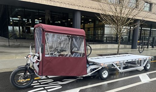
“Regardless of what these campuses are moving, they have the same core challenge of moving as much cargo as possible while keeping operating costs as low as possible,” Liu said. “On top of that, emissions and safety are key concerns because most of this happens in pedestrian-heavy areas.”
Liu explained that the first customers for the cargo e-bikes are micro-mobility fleet operators at the forefront of sustainable transportation including Lime, Net Zero Logistics, and Amazon. Moving forward, the company is targeting campus environments for expansion. Liu said that “economics drives adoption” and believes the key to adoption is offering an affordable, American-made product that reduces vehicle fleet costs, increases safety, improves efficiency, and reduces greenhouse gas emissions.
—Megan Tsai, contributing writer
Related Resources

Research assesses roles and impacts of Minnesota’s local airports
Reprinted from Catalyst, January 22, 2025
To better understand how Minnesota’s small public airports affect their local economies, researchers from the Transportation Policy and Economic Competitiveness Program (TPEC) at the University of Minnesota’s Humphrey School of Public Affairs chose three to profile from across the state. They shared their findings at the 2024 CTS Transportation Research Conference in a presentation highlighting the complex roles and community impacts of local airports.
The profile study built on a 2018 TPEC project that explored the value of airfreight networks for Minnesota’s medical supply chain. In addition, the researchers aimed to update information from a 2019 Minnesota Department of Transportation (MnDOT) study that examined the economic impact of 126 of the state’s 133 public airports.
“We were prompted by questions from several stakeholders, including TPEC advisory board members, to see if there were any travel changes or other impacts from the COVID-19 pandemic or high levels of inflation that had happened since those other studies were completed,” said Frank Douma, director of state and local policy and outreach at the Humphrey School’s Institute for Urban and Regional Infrastructure Finance (IURIF) and the project lead. The research team also included Barbara Rohde, IURIF researcher and licensed pilot, and Audrey Clark, an urban/regional planning graduate student.
Data for the three airport profiles was gathered through interviews with airport and city officials in February and May of 2024.
Granite Falls Municipal Airport
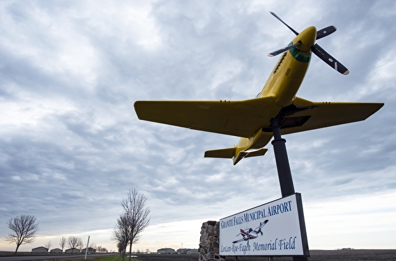
Unique among the three airports studied, the Granite Falls Municipal Airport in west central Minnesota receives no federal funding and attributes its ongoing success to the support of MnDOT and the local business community. A primary user for this 152-acre, one-runway airport is one of the biggest energy and ethanol firms in the Midwest—Fagen, Inc. The company hosts visitors from all parts of the US who travel to Granite Falls in corporate jets for meetings and tours.
The airport is also an active UPS hub—vital for supporting local resident and business needs—and draws tourists with a local bi-annual airshow held in association with the Fagen Fighters WWII Museum that showcases a collection of working aircraft from the era.
Mankato Regional Airport
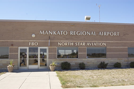
“It may be a surprise to some, but the Mankato Regional Airport is the second busiest in the state, following Minneapolis-St. Paul International,” Douma said of the airport located in south-central Minnesota.
Most of the operations on the airport’s two runways support and serve student pilots; North Star Aviation, a major US flight school, trains 700 aviation students who log more than 40,000 flight hours annually. “As a person who has taken many flight school lessons, I was so impressed,” said Rohde. “These kids fly until 11 at night to get their time in.” The school provides a direct recruitment pipeline to Minneapolis-based Sun Country Airlines.
The airport also serves the area’s retail, agriculture, and health care industries, which include:
- A 450,000-square-foot Walmart Distribution Center that opened in 2015 and is undergoing a major expansion.
- Veterinarians who board planes every morning to travel the country for swine testing.
- Mayo Clinic helicopters, based here to take advantage of the central location.
Roseau Municipal Airport
Ten miles south of the Canadian border, Roseau Municipal Airport mostly serves the Polaris company’s 1,500-employee manufacturing facility, ferrying executives and researchers across the US from the airport’s single paved runway. Additionally, the airport focuses on supporting community development and health care access with medevac transportation.
Conclusions and next steps
Local airports contribute significantly to the economic competitiveness, community pride, and identity of the Minnesota cities that host them, the researchers found. However, the nature of those contributions is different for each airport, encompassing transportation links, business facilitation, tourism, and emergency services.
A subgroup of TPEC advisory board members recently formed to further expand this research and seek national, state, and institutional partnerships.
—Jacqueline Bass, CTS program editor
Related resources
- Research Brief: Sustaining Minnesota’s Medical Device Industry Cluster: A Vital Role for Multimodal Transportation (2022)
- Article: An airport’s story: Granite Falls Municipal Airport (2019)
- Article: An airport’s story: Roseau Municipal (2020)
- Article: An airport’s story: Mankato Regional Airport (2013)

New Project: Impact of Asphalt Lift Thickness on Pavement Density and Durability
Pavement durability depends on its density. Achieving adequate density depends on the size of the aggregate in the mixture and the asphalt lift thickness—the height of the asphalt layer that is applied by the paver and compacted.
Continue reading New Project: Impact of Asphalt Lift Thickness on Pavement Density and Durability
MnDOT and the Local Road Research Board Fund New Research Projects to Address Critical Transportation Issues
MnDOT and the Local Road Research Board have funded 27 new research projects out of 82 proposals submitted this year. Every MnDOT and LRRB project is guided by a Technical Advisory Panel, with each member serving an important role in the success of the project. MnDOT and LRRB are actively seeking volunteers to serve as Technical Advisory Panel members. TAP members will help with guiding research and reviewing final project deliverables.
To receive updates on any of the funded projects, select “subscribe” on the project webpage.
Bridges and Structures
Environmental
- Quantifying the Influence of Driver Behavior on Greenhouse Gas Emissions and Air Quality
- Incorporation of Soil Health Engineered Measures on MnDOT Construction Projects and Resilient Stormwater Management
- Innovative Stormwater Solutions for Linear Projects
- Feasibility of LED Solar Street Lighting
- Development of Biochar Specification Criteria as Soil Amendment for Slopes, Conveyances and Stormwater Treatment Systems, Phase 2
Maintenance Operations
Materials and Construction
- Tools to Improve the Durability of Asphalt Pavements
- Feasibility of InSAR for Continuous Monitoring of Ground Deformation and Performance Tracking of Geotechnical Assets
- Evaluating and Implementing Ground Penetrating Radar (GPR) for Continuous and Rapid Monitoring of Moisture Fluctuations in In-service Roads
- Are Current Rigid Pavement Roundabout Designs Working in Minnesota?
- Holistic Design and Selection Criteria for Unbound Geomaterials Used in Pavement Systems
- Design Guidance and Best Practices for the Use of Light Fill
Multimodal
- Navigating Healthier Community Outcomes with Transportation Corridor Rankings
- Operational Characteristics of Conventional and Electric-Assisted Bicycles and Their Riders
Policy and Planning
- Leveraging Transportation Investments for Economic Development and Wealth Building
- Refining the Understanding of Parking Space Requirements and Its Impact on Vehicle Miles Travelled
- Speed Impacts on Complete Streets Elements, Phase 2
- Freeway Corridor Economic Impact
Traffic and Safety
- High Tension Cable Median Guardrail Expected Lifespan
- Use of Colors in Dynamic Message Signs for Both Travel Times and Static Sign Simulation
- Evaluation of Driver Speeds After Implementation of Speed Limit Reduction on Urban Streets
- Estimating Likely Mode Shift and Vehicle Miles Travelled Reduction Potential Using TBI Data and AI Algorithms
- Bike Infrastructure Planning Based on Mobile-Sourced Data and Anticipated Route Shifts
- Exploring Completeness and Accuracy of Driver Crash Reporting of Property Damage Only Crashes
- Leveraging C-V2X and Advanced Communications/Sensing for Rural Road Safety
- A Novel Red Light Running Warning System Using Connected v2i Technology, Phase 2: Driver Testing on Public Roads

New Project: Speed Impacts from Roundabouts and Other Traffic Control Devices
Roundabouts are effective at reducing driver speeds and lowering serious crash rates compared to other intersection types. Speeds vary in roundabouts, however, depending on geometric factors such as the number of lanes, entry and exit widths, and diameter. The use of supplementary control devices such as sign types, sign placement and pavement markings may also impact entry and exit speeds.
Continue reading New Project: Speed Impacts from Roundabouts and Other Traffic Control Devices