Like a traditional flagger, an Automatic Flagger Assistance Device directs drivers through work zones and other problem areas. But whereas traditional flagging requires workers to stand dangerously close to moving traffic, AFADs can be operated remotely, keeping the flaggers out of harm’s way.
“This is a very risky environment from our employees,” MnDOT Research Services Project Advisor Alan Rindels said. “Any flagger you talk to can recount a time he or she had to jump in a ditch to avoid a vehicle.”
Using a remote control, a single worker can easily operate two AFADs simultaneously, freeing up personnel to perform other tasks and speed up the completion of a road project. MnDOT estimates that the resulting cost savings can cover an AFAD’s purchase costs within two years.
MnDOT recently undertook a pilot implementation of three sets of AFADs, introducing them to maintenance staff and identifying the most appropriate situations for their use. Researchers reviewed past AFAD use in Minnesota, observed traditional flagger and AFAD operations in action, interviewed MnDOT maintenance personnel about their experiences and held two hands-on training sessions that were attended by more than 60 people.
Results showed that drivers obeyed the AFAD instructions and that AFADs work well for stationary construction projects. These successful demonstrations should encourage the wider use of AFADs and enhance worker safety in a cost-effective way.
MnDOT Research Services & Library produced the video above, which details the experiences of a MnDOT road crew who recently started working with AFADs.
(Bonus: Watch MnDOT flagger Joe Elsenpeter talk about jumping into a ditch to avoid being hit.)
*Note: This blog post was adapted from an article in the latest issue of our newsletter, Accelerator. Click here to subscribe.
The results of last season’s deicing study are in — just in time for our next snow.
Last winter, Minnesota State University researcher Steve Druschel set up experimental lanes at two Shakopee entertainment parks and a test site on a Mankato bridge to examine the life cycle of winter maintenance, from plowing and the application of chemicals to the drainage of chemical residue after the roadway has been treated.
What the Study Found
The majority of chloride appears to leave the roadway by plow ejection, vehicle carry-away or tire-spray spreading, rather than through storm drainage, even in warmer storms.
Pavements don’t hold chloride very long in a precipitation event, even after anti-icing/pre-treatment.
Deicer effectiveness. Warmer temperatures provide more melt from the deicer. Little melt was observed below
10 degrees Fahrenheit unless sunlight provided warming, and prewetting produced no significant difference in deicer performance.
Dry pavements may be better candidates for pretreatment, with researchers noting that any wetness on the pavement ahead of a storm limited anti-icer effectiveness.
Truck traffic after deicer application was found to significantly improve deicer performance, resulting in both a wider and quicker melt.
Plow effectiveness. Even with different snow and temperature conditions, the evaluation of plow speed provided the same findings: snow rises higher in the curvature of the plow at higher speeds, creating a broader spray off the plow ends, and higher speeds decrease scrape quality.
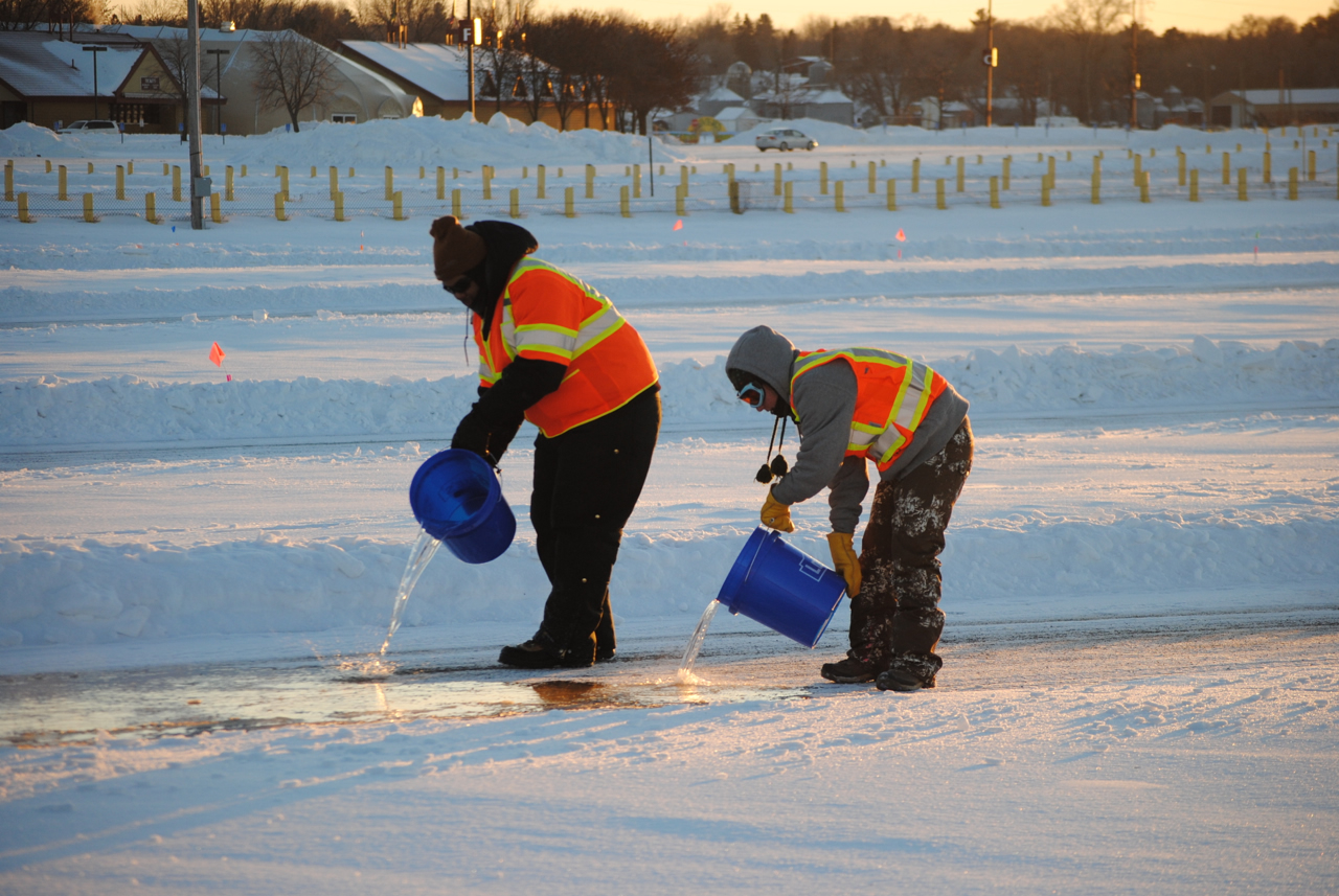
Students pour water to form ice on a test lane in Shakopee.
What’s Next?
The research team has proposed a third phase of this project to continue their work in the field, which is expected to include further examination of the impact of truck traffic on deicer effectiveness, variations in plow setup and expanded testing under varying weather conditions and snow structure.
Related Resources
Field Effects on Deicing and Anti-Icing Performance – Technical Summary (PDF, 1 MB, 2 pages); Final Report (coming soon)
Salt Brine Blending to Optimize Deicing and Anti-Icing Performance –Technical Summary (PDF, 1 MB, 2 pages) and Final Report (PDF, 11 MB, 151 pages) (previous study)
A revised handbook offers Minnesota cities and counties the latest tips on how to meet new sign retroreflectivity requirements, as well as the 411 on sign maintenance and management – everything from knowing when it’s time to remove a sign to creating a budget for sign replacement.
The best practices guide – produced in conjunction with a new sign retroreflectivity study – also offers case studies from around the state.
“The life cycle of traffic signs, from installation to replacement, is a pretty complex issue and it can be a challenge to get your arms around,” said Tim Plath, Transportation Operations Engineer for the city of Eagan. “This handbook really boils it down into some basic concepts and also gives you the resources to dig deeper if necessary. It’s a good resource to have at your fingertips.”
This handbook updates a previous version issued in 2010, to include new FHWA retroreflectivity and maintenance and management requirements and deadlines.
“Maintenance/management of a large number of signs can potentially be an administrative and financial challenge for many local road authorities,” explained Sulmaan Khan, MnDOT Assistant Project Development Engineer.
Here’s a video demonstration of a sign life reflectometer (the Gamma 922), another resource MnDOT has available for local government agencies. Cities, townships or counties may borrow the reflectomer by contacting the Office of Materials and Road Research, (651) 366-5508.
How do you quickly and cost-effectively get an accurate inventory of transportation assets spread out along more than 1,100 miles of roadway?
That was the problem facing the Minnesota Department of Transportation’s Metro District, which needed an inventory of its plate beam guardrail and concrete barriers.
To accomplish this, engineers in the district launched an innovative research implementation project using a pair of mobile mapping technologies — Light Detection and Ranging (LiDAR) and mobile imaging — that can collect vast amounts of geospatial data on highway infrastructure in a safe and efficient manner.
Mobile imaging uses a camera mounted on a vehicle driving at highway speeds to take high-resolution photos at regular intervals. It’s accurate to within 1 foot, which makes it suitable for use in preliminary (30 percent) design plans without additional field surveys. In this project, researchers collected mobile images of roadway barriers and extracted data from them along Metro District roadways, including all ramps, overpasses, interchanges, weigh stations, rest areas and historical sites.
A MnDOT worker replaces a section of broken guardrail on I-94 near the Lowry Tunnel in Minneapolis. (Photo by Dave Gonzalez, MnDOT)
Researchers also collected LiDAR data at three Metro District sites. LiDAR uses a laser range finder and reflected laser light to measure distances. It provides survey-grade data accurate to within 0.1 foot, but it is significantly more expensive to collect than mobile imaging.
“Mobile imagery and mobile LiDAR are relatively new technologies, but this research shows that they are options that we can use. Collecting this information manually would have taken a lot more time and money,” said MnDOT Asset Management Engineer Trisha Stefanski.
MnDOT’s barrier inventory will provide invaluable information for design, planning and maintenance. The data will be published on MnDOT’s Georilla map server, where it will be beneficial to a variety of projects and recurring tasks. For example, if a vehicle hits a barrier, maintenance staff will be able to check the database to see the type of barrier and end treatment to ensure they bring the right equipment to make repairs. Although the project focused on barriers, the imagery contains data on other assets as well. MnDOT has already used the imagery to extract noise wall and sign data.
Thanks to a flexible new contracting method, the cost and time of delivering small highway projects in Minnesota should go down.
The Minnesota Department of Transportation is now able to put road construction contractors on standby for certain types of projects, rather than bid each project individually, due to the adoption of Indefinite Delivery/Indefinite Quantity (IDIQ) contracts.
“IDIQ contracts give MnDOT more flexibility and the ability to get to the field quicker for work that we need repeated routinely, such as culvert repairs, overlays and seal coats,” said Kevin Kosobud, project development engineer with MnDOT’s Office of Construction and Innovative Contracting.
IDIQs also provide flexibility when needs are uncertain. Contracts are often used for multiple small projects that are similar in scope, but difficult to quantify in cost and timing.
For instance, the state of Florida awards IDIQs for hurricane debris removal, activating and paying contractors only when a hurricane necessitates the service.
Although IDIQs showed great promise, MnDOT had to develop a framework to implement them.
The federal government has used IDIQ contracts since the 1980s, but only a small number of state DOTS have used them to procure construction services. No standard procedures existed for their use by state DOTs, and federal procedures are not always applicable at the state level.
MnDOT hired Iowa State University researchers to examine IDIQ usage across the country and develop implementation procedures for Minnesota. (Read a summary of their research here.)
Researchers examined contracting practices at 14 different transportation agencies to recommend guidelines for Minnesota to follow, which allowed MnDOT to begin awarding IDIQ contracts in April 2013.
Case study analyses show clear benefits where IDIQ has been used: acceleration of the project delivery period, reduced construction costs and flexible delivery scheduling.
“IDIQs can help DOTs get better prices for routine services via an economy of scale, for instance, by awarding a contract for a larger number of culvert repairs rather than awarding a single contract for each repair,” explained Doug Gransberg, professor of construction engineering at the Iowa State University Institute of Transportation.
Agencies can award IDIQ contracts individually or collectively.
With a single-award contract, a single contractor is awarded task orders based on the pricing furnished in the initial bid package; multiple-award contracts determine a pool of qualified contractors who may subsequently bid on task orders.
*Editor’s note: This article was adapted from the September-October 2014 issue of our Accelerator newsletter. Read it online or sign up for your free subscription.
Related Resources
Leveraging the Advantages of Indefinite Delivery/Indefinite Quantity Contracts – Technical Summary (1 MB, 2 pages); Final Report (expected Fall 2014)
A new video produced by the Local Road Research Board helps the public understand why some bad roads aren’t always fixed first.
The seven-minute video explains what causes road pavements to deteriorate and why, like the saying, “throwing good money after bad,” it may be more cost-effective to put maintenance dollars into roads that still have life left in them versus roads that are in the worst condition.
In it, city and county engineers discuss how they use a pavement management program to decide which roads to fix when, in order to stretch limited resources in the most effective way possible.
“We’ve learned that if we wait for things to break and fall apart, they’re much more costly to replace than if we put a little bit into it during its life cycle,” says Mark Maloney, City of Shoreview public works director.
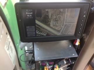
Putting GPS units on MnDOT highway mowers is expected to speed mowing operations and cut herbicide usage by 50-percent in metro area ditches, reducing groundwater contamination.
MnDOT’s Metro District highway maintenance division will be one of the first — if not the first — state agencies in the country to equip the majority of its maintenance tractors with Automated Vehicle Location systems.
Not only will crews be able to effortlessly track their progress — reducing paperwork and freeing time for other maintenance activities — but the AVL’s live mapping software will help them avoid noxious weed patches, thereby reducing their spread.
Last year, MnDOT tested the GPS software on five mowers.
“AVL alone enables the tracking of vehicle positions, but when combined with equipment sensors and an on-board monitor with user interface, it becomes a very innovative way to reduce operation costs,” said MnDOT Project Engineer Trisha Stefanski, who applied for funding from MnDOT’s Transportation Research Innovation Group for the pilot project.
Vehicle tracking systems have been shown to reduce chemical usage by crop farmers, improve route efficiencies in truck driving and help cities and counties track snowplows.
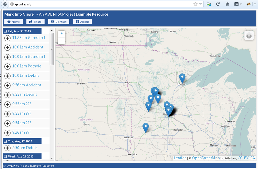
The on-screen mapping shows the location of weed patches, so mowers can avoid them, reducing their spread.
MnDOT Metro, which tested five AVL units last year, hopes to equip as much of its remaining fleet as possible.
In the grant application, Stefanski estimated the technology will pay for itself in about a year’s time, largely due to herbicide savings.
Noxious weeds
MnDOT is required by law to manage certain noxious weeds along its highways. Each year, weed inspectors survey one-quarter of metro ditches for weeds, which enables them to concentrate eradication efforts on the worst areas.
Touch-screen maps will contain the noxious weed locations so operators can see weed patches and mow around them.
Herbicide usage is estimated to drop an estimated $100,000 to $150,000 per year. (This estimate was based on the original funding request. Final numbers haven’t been released.)
Operators can use the on-screen map to mark the location of new patches of noxious weeds.
Noxious weeds like Wild Parsnip — which can cause painful skin boils — might even be eradicated, reducing the risk for field crews, such as construction workers and Adopt a Highway volunteers.
Until now, maintenance crews have relied on paper maps to identify weed locations, which is less effective.
“What’s better, looking at a live screen when you’re going down the road and seeing where weeds are coming up, or trying to refer to a piece of paper?” Stefanski said.
Other advantages
The AVL equipment will also allow for automated reporting.
Mower operators can use the on-board AVL monitor to mark the location of guardrail hits, potholes, washed-out culverts, debris and unmarked noxious weeds.
Operators can electronically mark the location of guardrails, debris, potholes and more.
Currently, operators must track their activities using hand-written forms or spreadsheets in the office.
The AVL system will also automatically track their location history, allowing operators to optimize their routes based on how long it took to mow segments in the past.
It will also be easier to answer questions from the public, who want to know the last time a certain ditch was mowed.
“Making everything geographically located adds so much analysis opportunity,” Stefanski said.
MnDOT also has AVL technology on an herbicide applicator to better track where it’s sprayed. Other future potential applications including pothole patching and road sweeping operations, Stefanski said.
Excalibur and the High Roller may be closed for the season, but Valleyfair Amusement Park still has one attraction open for the season: a driving track for Minnesota snowplow drivers.
MnDOT-funded researchers are studying the effects of weather and vehicle traffic on different deicing treatments in the parking lots of Valleyfair and Canterbury Park in Shakopee, Minn.
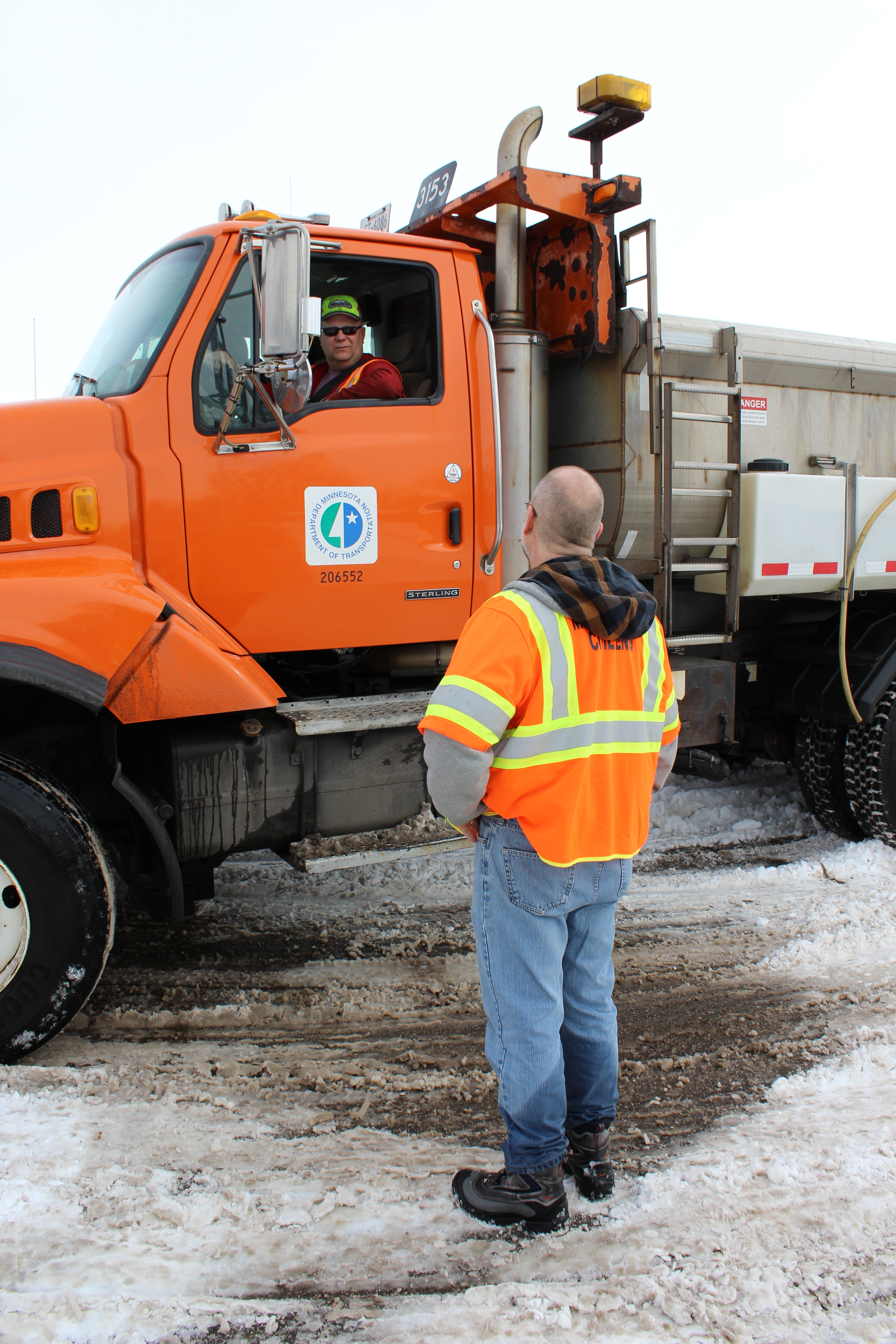
It’s been a busy winter, but each week MnDOT Metro District snowplow drivers make one last stop before heading home, to apply different combinations of salt and anti-icing chemicals to nine 1,000-foot driving lanes. They also drive over each lane multiple times to test the effect of traffic.
“We’re running trucks up to 30 miles per hour with different speeds, wind conditions, traffic conditions and pre-wetting chemicals,” said Steve Druschel, a researcher with the Minnesota State University, Mankato. “Each lane is its own experimental unit.”
Professor Steve Druschel speaks with MnDOT snowplow driver John Hokkanen.
Professor Druschel’s students will review more than 17,000 photos from time-lapsed cameras to document how the snow melted in each experimental run.
“The influence of factors like pavement type and age, traffic volume, truck proportion, weather conditions and sun presence will be assessed to evaluate which techniques have special advantages for certain situations or roadways,” said Maintenance Research and Training Engineer Tom Peters.
In 2010, Druschel tested 25 anti-icing compounds in 1,500 different combinations in a laboratory to study the effectiveness of different deicers.
“Public work superintendents commented, ‘Great work. It looks good, except it’s all in the lab. Beakers aren’t what people drive on,’ ” Druschel said. “So we’re taking it from the two-inch ice cup to the real world in phase two of this study.”
With rock salt prices quadrupled, finding the most cost-effective methods of treatment is important.
This latest research will help determine the best times for applying anti-icing treatments and examine whether certain chemicals — such as a pre-storm liquid treatment that costs twice as much — melt enough snow to be worth the extra cost.
Test runs in Shakopee are strictly experimental, but in Mankato students are analyzing how real-world salting treatments are working on the North Star Bridge.
An article in the Mankato Free Press tells how Druschel’s team is collecting road melt runoff and documenting bridge traffic. (Big trucks, for instance, squeeze more water out of the snow.)
MnDOT snowplow driver John Hokkanen makes a test run at the research site at Canterbury Park. (Photo by Nick Busse)
Students plan to use time-lapsed photos, along with weather data and snowplow records, to determine what chemical treatments worked best – and when.
With the multi-pronged research project, Druschel hopes to put definitiveness to what some snowplow drivers have already tried in the field.
“The key to it is not so much that we’re so smart and we have a better idea or are inventing something new,” he said. “We’re just trying to enhance what they are already doing.”
Helpful resources
Salt Brine Blending to Optimize Deicing and Anti-Icing Performance –Technical Summary (PDF, 1 MB, 2 pages) and Final Report (PDF, 11 MB, 151 pages) (previous study)
Even naturally derived products like corn syrup and beet juice can impact the environment when applied to salt mixtures for winter roadways.
A wide range of products, including the ones mentioned above, are added to deicing mixes to limit the amount of salt needed for Minnesota roads each winter. However, although information is available about the corrosive properties of various deicing chemicals, less is known about the toxicity of these compounds, especially to the aquatic environment.
Thanks to a recently completed project sponsored by the Clear Roads Pooled Fund, MnDOT winter maintenance personnel will better understand the relative toxicity of eight common deicing agents, which also include non-organics like Magnesium Chloride, Calcium Chloride and Potassium Acetate.
“Because the state has been trying a lot of different alternative chemicals, we wanted to get a better handle on the environmental impacts,” said MnDOT engineer Tom Peters, the technical liaison for the 26-member, Minnesota-led pooled fund for winter maintenance research.
In January, researchers plan to release a concise summary of the toxicity rankings to help winter highway maintenance managers consider both expected levels of service and potential harm to the environment when selecting a deicer.
Minnesota is the lead state for the Clear Roads Pooled Fund, which conducts rigorous testing of winter maintenance materials, equipment and techniques. Other recent and upcoming research (see our Technical Summary on the program) includes a winter maintenance cost-benefit analysis toolkit, snow removal techniques at extreme temperatures and environmental factors that can cause fatigue in snowplow operators.
You can learn more about Clear Roads via the project’s e-newsletter.