A long-running series of U of M research projects aimed at improving stormwater quality are beginning to see practical application by stormwater specialists from the Twin Cities metro area and beyond.
Webinar materials and a new FAQ about the Mobility, Access, and Transportation Insecurity (MATI) Program RFP process are now available on the MATI website.
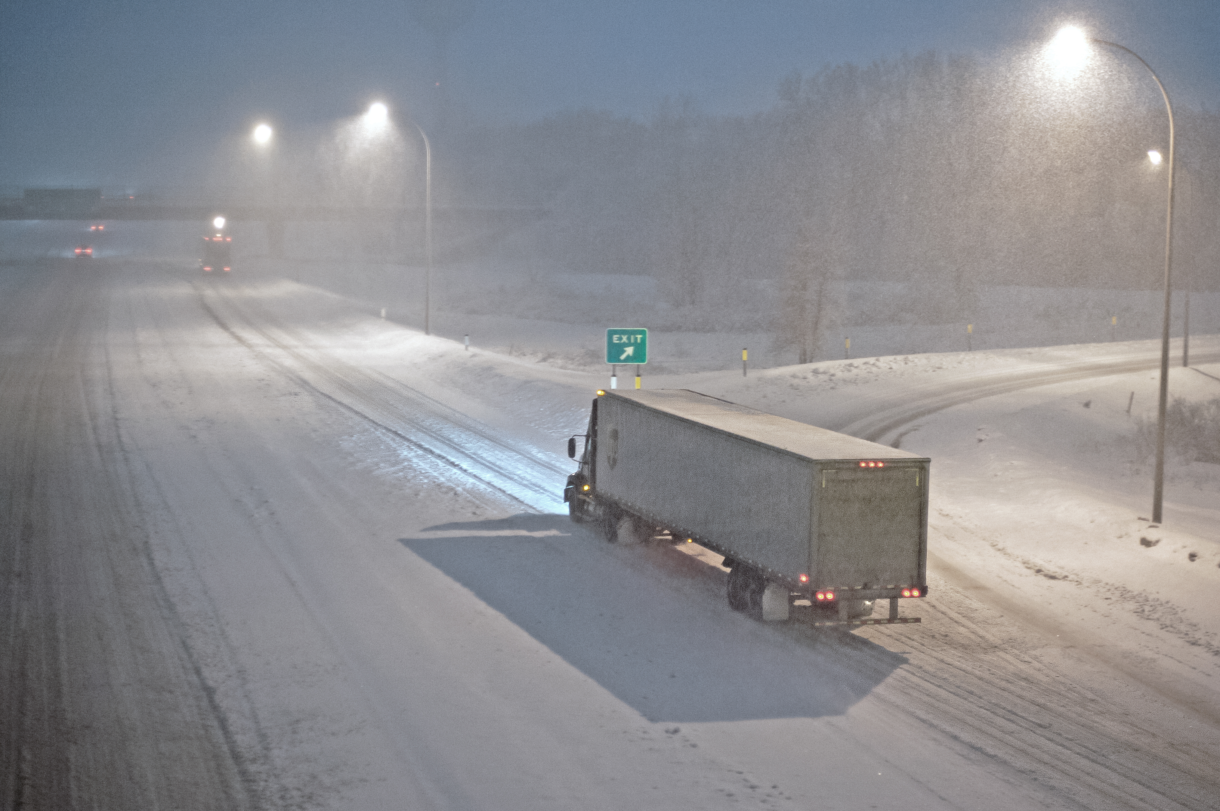
By Megan Tsai, reprinted from CTS News, February 8, 2024
Aiming to eliminate barriers to electric truck adoption in Minnesota, U researchers have identified the state’s most suitable e-truck charging locations.
Currently, the adoption of electric medium- and heavy-duty trucks is lagging compared with the rising popularity of personal and transit electric vehicles. There are several reasons behind the delay, but one key factor is the lack of an adequate charging station network for e-trucks. The Minnesota Department of Transportation (MnDOT) called on U of M researchers for insight and guidance.
“Our goal was to understand the needs and opportunities for e-truck charging stations and to optimize the location of charging stations in Minnesota, ” says Alireza Khani, associate professor with the Department of Civil, Environmental and Geo-Engineering and the project’s principal investigator.
The project was conducted in two stages. In the first stage, researchers identified the most important criteria to consider when planning e-truck charging stations; this was done with a survey of experts and stakeholders, including staff from MnDOT, the Freight Mobility Research Institute, and the American Trucking Associations.
Based on this survey, researchers ranked the relative importance of the criteria and assigned each a weighted value. The top three criteria were ease of access for e-truck drivers, proximity to power substations, and proximity to existing truck stops. Other criteria included environmental conditions (land cover, water resources, and flood risk), land prices, and the potential to generate onsite solar energy.
During the second stage, researchers developed geographic information system layers for each criterion and pared down candidate locations using optimization modeling. The model was designed to consider truck demand in Minnesota, the routing and charging activities of e-trucks, and the market penetration rate of e-trucks, with a goal of minimizing total travel costs to promote greater adoption of e-trucks.
“This optimization model is a novel decision-making tool that will help MnDOT maximize its return on investment in the charging station network,” Khani says. “The model can be expanded to incorporate other contributing factors and inform policy decisions.”
To gain additional insight into Minnesota e-truck adoption, researchers tested the model with several assumptions based on the reduced per-mile operating costs of e-trucks over diesel trucks. They found that the adoption of e-trucks would grow sharply as the charging station network is developed; the growth rate would be highest when the first 30 to 40 stations are added. The modeling also found that solar generation was not a viable option to fully power truck charging stations.
“This project helped us understand considerations for e-truck charging stations, such as electric power substation location and capacity,” says Andrew Andrusko, freight planning director with MnDOT’s Office of Freight and Commercial Vehicle Operations. “It also identified optimal locations for truck charging stations to support intrastate freight movement.”
Green means go and yellow means go faster—so goes a wry take on driver behavior at traffic signals. But it’s not just travel time that increases when you brake for a red: Fuel consumption does, too. Could transmitting signal data to connected vehicles (CVs) reduce stop-and-go cycles and fuel use? U of M researchers say yes.
Eliminating intersection bottlenecks is one of the most persistent and difficult challenges for traffic engineers. A new mathematical theory called “max-pressure signal control” has been proven to achieve maximum throughput for entire city road networks, but it has not yet been used in practice. In a new study, U of M researchers brought the theory several steps closer to real-world use and found that it could offer many benefits to Minnesota road users.
“For most intersections and demand periods, we found that max-pressure control offered significant improvement over current signal timings,” says Michael Levin, an assistant professor with the Department of Civil, Environmental, and Geo- Engineering. “Large reductions in delay—sometimes over 50 percent—suggest that this new method of signal timing could achieve higher throughput during peak demand and be more responsive to queues.”
To achieve these findings, researchers began by addressing some aspects of max-pressure signal timing that would make it difficult to implement in a real-world setting. First, researchers addressed its assumption that all roadways had separate turning lanes by adapting the mathematical model to accommodate mixed travel lanes.
Another drawback of the original formula is that the signal control doesn’t operate on a cycle; this could cause long wait times when demand is uneven and make the signal cycle unpredictable for both drivers and pedestrians.
“To solve this issue, we modified the formula to include a maximum waiting time and require that the phase selection follows a cycle,” Levin says. “This allows traffic engineers to create an ordered set of phases for each intersection.”
Once the updated version of max-pressure control was developed, researchers tested it in simulations of two corridors in Hennepin County, Minnesota. The simulations revealed numerous potential benefits including reduced environmental impacts and reduced road user costs resulting from travel time savings and lower fuel costs.
“The findings show that our new max-pressure control formula will reduce the average queue length during peak hours and that vehicles will not wait as long at intersections,” Levin says. “We can also predict higher throughput and faster vehicle speeds, all of which will mitigate congestion and improve quality of life.”
In addition, a cost-benefit analysis shows that the total value of travel time savings is considerably larger than the cost to implement max-pressure control.
The project’s success led researchers to explore the possibility of a real-world pilot project with available traffic signal hardware. They found that the traffic signal technology currently used in Hennepin County could be upgraded to support a pilot study, laying the groundwork for a future real-world test of this promising new signal timing method.
Transportation agencies revegetate roadsides after construction projects to provide road stability, stormwater filtration, and visual appeal. Revegetation is also a good opportunity to create pollinator-friendly habitat. However, planting and maintaining ditches can be expensive, funds for such projects are usually limited, and there isn’t much data on which methods actually work.
When a person wants to take a trip across the country, they can choose from a variety of travel planning apps to help make that happen. But what if the trip they want to take is from Mankato to New Ulm, or within their own community, using non-personal transportation?
The Minnesota Department of Transportation has launched a pilot project to bring trip planning and payment technology for daily trips to areas less dense than urban settings.
Residents and visitors in southern and western Minnesota now have the ability to plan for and, in some cases, pay for public transit and intercity bus trips using the Transit app. Travel and route information for these agencies went live within Transit on March 1.
Transit, a free app available for download in Google Play or the Apple App Store, is used in more than 300 cities around the world. It allows users to see route and travel options for public transit and connecting services. Select agencies also have in-app ticketing, allowing riders to pay for fares electronically and then show their device to transit drivers to ride.
“This pilot with the Transit app focuses on rural areas because this technology has not yet been made available outside of Minnesota’s big cities,” says Elliott McFadden, MnDOT’s Greater Minnesota Shared Mobility Program coordinator. “The project will be the first to bring the latest technology to make it easier to plan and take trips in many communities in Greater Minnesota.”
The pilot will run through April 2024 and is funded by two innovation grants from the Federal Transit Administration at a cost of $1.9 million.
U of M researchers led by Alireza Khani will evaluate the project to help determine whether this technology should be scaled to the rest of the state. Focusing on southern Minnesota, the research team will work closely with MnDOT’s project management team and the platform development team to study these questions:
How do residents of the region benefit from having access to a variety of mobility options through an integrated platform?
To what extent does the platform help increase transit ridership and reduce personal vehicle use?
How can the features of the platform—such as route planning or pricing—be optimized for greater system efficiency and benefits for all residents?
“Our goal is to provide the data and analysis policymakers need to make the most effective transit investments,” says Khani, an associate professor in the Department of Civil, Environmental, and Geo- Engineering.
A new book—Space, Structures, and Design in a Post-Pandemic World—explores the rebalancing of our physical and digital interactions and what it means for the built environment going forward.
Darryl Oeltjenbruns, snowplow driver in District 7, operates the only driver assist system, or DAS, equipped snowplow in the state. The system helps snowplow operators see road alignments and features such as turn lanes, guardrails and road markings. (Photo by Chase Fester)
By Sue Roe, MnDOT Communications
Southwest Minnesota has the highest average wind speeds in the state—bad news for MnDOT snowplow operators who often drive in low visibility to clear roads.
“We have more days when the wind blows than when it doesn’t,” said Chase Fester, MnDOT District 7 transportation operations supervisor. “We struggle with the wind.”
That’s why District 7 is piloting a snowplow driver-assist system (DAS) developed by University of Minnesota researchers to combat the blowing snow and fog that often cause zero visibility. The DAS helps snowplow operators see the road alignment and features, such as turn lanes, guardrails, and road markings. Even in less extreme winter weather, snowplow operators gain assurance of their lane location using the system.
The driver assist system displays a white box on the screen when an obstacle, or in this case a mailbox, is located. If the object appears in the lane, such as a car stuck in a snow drift, the box turns red and gets bigger as the snowplow gets closer to the object. (Photo courtesy of MnDOT District 7)
The DAS was developed and refined over the past 20 years under multiple research projects funded by MnDOT and the USDOT’s University Transportation Center program. Professor Max Donath, director of the University of Minnesota’s Roadway Safety Institute, led the work. In addition to plows, the DAS technology has also been applied in other specialty vehicles such as patrol cars and ambulances. Numerous vehicles using the system have been deployed in both Minnesota and Alaska.
The DAS uses GPS technology and a front-mounted radar to provide an image of the road and any obstacles in front of the operator. The image is displayed on a monitor inside the cab of the plow. The system also vibrates the operator’s seat as a warning if the plow veers too close to the roadway’s centerline or fog line.
“If the driver gets within one foot of the fog line on the right side, the right side of the seat vibrates. If the driver gets too close to the centerline on the left side, the left side vibrates,” said Fester.
The vibrations continue until the driver moves back into the center of the lane. The driver can also turn off the warning feature to clear snow from the shoulder.
The DAS is currently installed in one truck in District 7. The $75,000 cost makes it difficult to install in every truck in the district or the state, although having at least one system in every district may be possible, Fester said.
Fester said the system proved its worth one day in February when blizzard conditions caused zero visibility and forced many road closures in southwest Minnesota. He was called out at 2 a.m. Feb. 8 to assist a stranded state trooper and several motorists on a 12-mile stretch of Hwy 60 between Windom and Heron Lake. Fester drove a pickup behind the DAS-equipped snowplow, driven by Darryl Oeltjenbruns, to reach them.
As the DAS identified stranded vehicles on the way to Heron Lake, Fester and Oeltjenbruns checked to make sure they weren’t occupied with people. Once they made it to Heron Lake, they stopped at the community center, where the state trooper and the stranded motorists he brought in were located.
On the way back to Windom, Fester and the state patrolman continued to check on stranded vehicles as the DAS-equipped snowplow led the way. If the vehicles weren’t in the ditch, motorists drove behind the two MnDOT vehicles. If their vehicles were in the ditch, motorists rode in a Suburban that was also being escorted to Windom. After returning to Windom, the motorists were dropped off at motels or truck stops.
“When we first went out, there were about six stranded vehicles. Coming back from Heron Lake, there were about 15,” Fester said. “At one time, we had 12 vehicles in line as we drove back to Windom, driving about 10 to 15 miles per hour.”
Later that morning the DAS system was used again to locate other motorists.
“We continued to use it until about 10 a.m. or 11 a.m. that day,” Fester said. “The system worked great and kept everyone safe. It was an interesting morning.”
(Reprinted and adapted with permission from an article by Sue Roe in MnDOT’s Feb. 17, 2016 Newsline.)
Results of a newly released MnDOT research report shed new light on the role transportation plays in our state’s economic competitiveness, and highlight the unique challenges faced by some of the state’s major industry clusters.
The report, authored by Professor Lee Munnich of the University of Minnesota’s Humphrey School of Public Affairs, underscores the importance of a reliable transportation system in facilitating economic growth. Munnich examined the impact of transportation on Minnesota’s competitive industry clusters — geographically concentrated, interconnected groups of companies and institutions that share knowledge networks, supply chains and specialized labor pools.
MnDOT Research Project Engineer Bruce Holdhusen said MnDOT’s goal with the study was to discover how its investment decisions could help support job creation and economic prosperity.
“The idea is to look at the companies and industries that are already bringing money into the state, figure out what their transportation challenges are, and then use that information to see what kind of investments we could make to support their continued growth,” Holdhusen said.
MnDOT is incorporating the results of the study into its statewide freight planning. The industry clusters-approach also is being used by MnDOT in a statewide effort to talk with manufacturers, other shippers, and carriers about their transportation priorities and challenges. MnDOT will focus on its Metro District starting this summer. Two similar projects have been undertaken in Greater Minnesota, with a third study starting later this year. (Results from one study, in southwest Minnesota/District 8, are available online.)
The full report is available online, and examines a wide range of industries, including forest products, medical devices, robotics and processed foods. We’ve pulled out a few interesting tidbits below.
Recreational Vehicles (Northwest Minnesota)
Minnesota winters are great for snowmobiling, but not always great for shipping snowmobiles. (Photo by Dave Gonzalez, MnDOT)
As noted in the report, Minnesota’s extreme winter weather poses unique challenges to its economic competitiveness. Ironically, nowhere is this more evident than in the state’s snowmobile-producing northwest corner.
Polaris and Arctic Cat (together with smaller, more specialized firms like Mattracks) employ thousands of Minnesotans, producing a wide variety of recreational vehicles and accessories that are sold and distributed all over the world. While the companies’ snowmobiles might fare well in a blizzard, the trucks that deliver them don’t. A bad snowstorm can cause delays in both supply and product shipments; it can also prevent employees from getting to work, or even shut down a plant altogether. On a larger scale, these issues make it difficult for the companies to expand at their ideal rates.
The report notes that MnDOT’s 511 system is an important source for many companies to identify and respond to potential shipping delays. It recommends continuous improvements to the system.
The Mayo Clinic (Rochester Area)
Air carriers like FedEx have limited capacity for refrigerated shipments, which creates challenges for shipping medical lab samples. (Photo by Dave Gonzalez, MnDOT)
The Mayo Clinic has become synonymous with the Rochester metropolitan area, and for good reason: it employs 37,000 residents and brings in 500,000 unique patients each year from all 50 U.S. states and 150 countries. As you might imagine, generating that much activity in a community of only 110,000 people creates some unique and significant transportation challenges.
Unlike most competitor institutions (Johns Hopkins in Baltimore, for example), the Mayo clinic is located in a relatively small metropolitan area. The local airport has an older navigation system and offers less direct commercial air service. As a result, it depends on high-quality transit and freight service to help accommodate the constant flow of visitors and supplies. The shipping of highly perishable lab samples is also a challenge, as air carriers have limited capacity for refrigeration. Finally, adverse weather conditions can affect emergency services dispatchers’ ability to send fast modes of transportation such as helicopters.
Hospitality and Tourism (Brainerd Lakes Area)
Lakeside resorts a great way to enjoy Minnesota’s scenic beauty — but getting there can be a challenge. (Photo by Dave Gonzalez, MnDOT)
The oil boom in North Dakota has generated a lot of wealth in a short amount of time, and resorts like the Grand View Lodge in Nisswa would love to capture some of it by enticing new vacationers from the west. The trouble is, the area is inconvenient to reach from that direction.
A four-lane highway makes it easy for visitors from St. Cloud or the Twin Cities to visit resorts in the Brainerd area, but travelers coming from the Dakotas face a more circuitous route. Air travel options help to an extent, as visitors from even farther distances can fly into Fargo and then drive in from there. St. Cloud also has daily air service from Chicago, which helps maintain a constant flow of visitors.