Tag Archives: transportation

Research assesses roles and impacts of Minnesota’s local airports

Reprinted from Catalyst, January 22, 2025

To better understand how Minnesota’s small public airports affect their local economies, researchers from the Transportation Policy and Economic Competitiveness Program (TPEC) at the University of Minnesota’s Humphrey School of Public Affairs chose three to profile from across the state. They shared their findings at the 2024 CTS Transportation Research Conference in a presentation highlighting the complex roles and community impacts of local airports.

The profile study built on a 2018 TPEC project that explored the value of airfreight networks for Minnesota’s medical supply chain. In addition, the researchers aimed to update information from a 2019 Minnesota Department of Transportation (MnDOT) study that examined the economic impact of 126 of the state’s 133 public airports.

“We were prompted by questions from several stakeholders, including TPEC advisory board members, to see if there were any travel changes or other impacts from the COVID-19 pandemic or high levels of inflation that had happened since those other studies were completed,” said Frank Douma, director of state and local policy and outreach at the Humphrey School’s Institute for Urban and Regional Infrastructure Finance (IURIF) and the project lead. The research team also included Barbara Rohde, IURIF researcher and licensed pilot, and Audrey Clark, an urban/regional planning graduate student.

Data for the three airport profiles was gathered through interviews with airport and city officials in February and May of 2024.

Granite Falls Municipal Airport

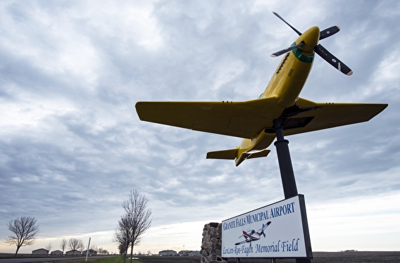
Plane mounted at entrance to Granite Falls Airport

Unique among the three airports studied, the Granite Falls Municipal Airport in west central Minnesota receives no federal funding and attributes its ongoing success to the support of MnDOT and the local business community. A primary user for this 152-acre, one-runway airport is one of the biggest energy and ethanol firms in the Midwest—Fagen, Inc. The company hosts visitors from all parts of the US who travel to Granite Falls in corporate jets for meetings and tours.

The airport is also an active UPS hub—vital for supporting local resident and business needs—and draws tourists with a local bi-annual airshow held in association with the Fagen Fighters WWII Museum that showcases a collection of working aircraft from the era.  

Mankato Regional Airport

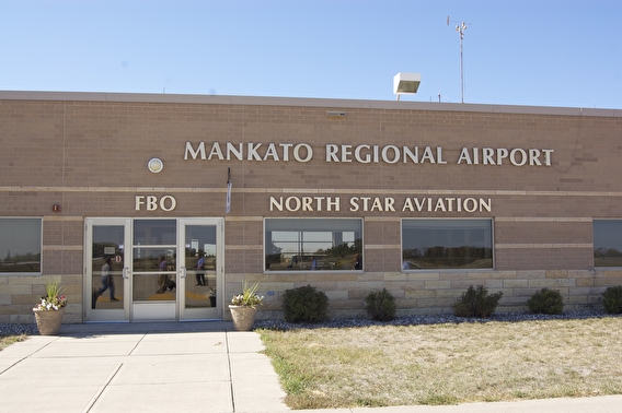
“It may be a surprise to some, but the Mankato Regional Airport is the second busiest in the state, following Minneapolis-St. Paul International,” Douma said of the airport located in south-central Minnesota. 

Most of the operations on the airport’s two runways support and serve student pilots; North Star Aviation, a major US flight school, trains 700 aviation students who log more than 40,000 flight hours annually.  “As a person who has taken many flight school lessons, I was so impressed,” said Rohde. “These kids fly until 11 at night to get their time in.” The school provides a direct recruitment pipeline to Minneapolis-based Sun Country Airlines.

The airport also serves the area’s retail, agriculture, and health care industries, which include:

  • A 450,000-square-foot Walmart Distribution Center that opened in 2015 and is undergoing a major expansion.
  • Veterinarians who board planes every morning to travel the country for swine testing.
  • Mayo Clinic helicopters, based here to take advantage of the central location.

Roseau Municipal Airport

Ten miles south of the Canadian border, Roseau Municipal Airport mostly serves the Polaris company’s 1,500-employee manufacturing facility, ferrying executives and researchers across the US from the airport’s single paved runway. Additionally, the airport focuses on supporting community development and health care access with medevac transportation.

Conclusions and next steps

Local airports contribute significantly to the economic competitiveness, community pride, and identity of the Minnesota cities that host them, the researchers found. However, the nature of those contributions is different for each airport, encompassing transportation links, business facilitation, tourism, and emergency services.

A subgroup of TPEC advisory board members recently formed to further expand this research and seek national, state, and institutional partnerships.

—Jacqueline Bass, CTS program editor

Related resources

Clear Roads: Winter Maintenance Research Roundup

New from clearroads.org on December 11, 2024

  • Performance of Ultra-Thin Bonded Wearing Course (UTBWC) During Winter Snow Ice Events in Maryland, Maryland DOT, August 2024. Research Summary.
  • ODOT‘s Snow and Ice Performance Evaluation Tools, Ohio DOT, August 2024.
  • Development of the Nebraska Department of Transportation Winter Severity Index – Phase II, Nebraska DOT, May 2024. Final Report.
  • Evaluation of Methods for UDOT Brine Tank Condition Assessment, Utah DOT, January 2024. Final Report.

Applying for Grants: Use Data to Tell Your Community’s Story to USDOT

Research done here at Minnesota and elsewhere has done much to define the problems of local communities with missing or declining infrastructure. USDOT offers federal assistance to build and improve that infrastructure, but the grants have to be won.

Continue reading Applying for Grants: Use Data to Tell Your Community’s Story to USDOT

Measuring the Livability Framework

MnDOT’s Office of Livability developed the Livability Framework to help guide planning, programming, and project development processes. It is being piloted in MnDOT Metro District.  The outcomes should result in more people focused outcomes for the plans, programs and projects in the District. The Livability Initiative wants each of the Livability Pillars of the Livability Framework to be thoroughly considered and evaluated when planners, project managers, and others make decisions about transportation policies, programs, and/or projects.

Continue reading Measuring the Livability Framework

Future of Mobility: Infrastructure Health and Security

Reprinted from Catalyst, November 9, 2023
—Pam Snopl

What’s next in the future of mobility? Infrastructure is always critical—the challenge of how to fund, protect, and maintain it continues unabated, whether from wear and tear or malicious cyberattacks. 

Continue reading Future of Mobility: Infrastructure Health and Security

Multimodal trip planner to make travel easier in Greater Minnesota, rural areas

Reprinted from Catalyst, May 9, 2023

When a person wants to take a trip across the country, they can choose from a variety of travel planning apps to help make that happen. But what if the trip they want to take is from Mankato to New Ulm, or within their own community, using non-personal transportation?

The Minnesota Department of Transportation has launched a pilot project to bring trip planning and payment technology for daily trips to areas less dense than urban settings.

Residents and visitors in southern and western Minnesota now have the ability to plan for and, in some cases, pay for public transit and intercity bus trips using the Transit app. Travel and route information for these agencies went live within Transit on March 1.

Transit, a free app available for download in Google Play or the Apple App Store, is used in more than 300 cities around the world. It allows users to see route and travel options for public transit and connecting services. Select agencies also have in-app ticketing, allowing riders to pay for fares electronically and then show their device to transit drivers to ride.

“This pilot with the Transit app focuses on rural areas because this technology has not yet been made available outside of Minnesota’s big cities,” says Elliott McFadden, MnDOT’s Greater Minnesota Shared Mobility Program coordinator. “The project will be the first to bring the latest technology to make it easier to plan and take trips in many communities in Greater Minnesota.”

The pilot will run through April 2024 and is funded by two innovation grants from the Federal Transit Administration at a cost of $1.9 million.

U of M researchers led by Alireza Khani will evaluate the project to help determine whether this technology should be scaled to the rest of the state. Focusing on southern Minnesota, the research team will work closely with MnDOT’s project management team and the platform development team to study these questions:

  • How do residents of the region benefit from having access to a variety of mobility options through an integrated platform?
  • To what extent does the platform help increase transit ridership and reduce personal vehicle use?
  • How can the features of the platform—such as route planning or pricing—be optimized for greater system efficiency and benefits for all residents?

“Our goal is to provide the data and analysis policymakers need to make the most effective transit investments,” says Khani, an associate professor in the Department of Civil, Environmental, and Geo- Engineering.

(Adapted from a MnDOT press release, March 1, 2023.)

More Information

Scholars reflect on critical transportation topics in new Future of Mobility series

What’s next in transportation? CTS’s new Future of Mobility series collects the perspectives of top University of Minnesota researchers and other national experts.

In 17 articles, the authors scan the horizon and reflect on critical transportation topics ranging from rural transportation to automated vehicles to equity for users. The future of transportation will be a complex, interconnected set of practices and technologies, and this series brings bold thinking together in one place.

Continue reading Scholars reflect on critical transportation topics in new Future of Mobility series

Reducing Driver Errors at Two-Lane Roundabouts

Researchers studied driving behavior at four multilane roundabouts to better understand the relationship between traffic control designs and driver errors. Data collected showed that certain traffic control changes decreased turn violations but failed to eliminate yield violations. Researchers were unable to identify long-term solutions for improving roundabout design and signage, and recommended further research to improve the overall safety and mobility of multilane roundabouts.

“Even though the study did not provide a silver bullet on how to prevent crashes at multilane roundabouts, it did create an efficient tool to analyze and quantify driving behavior data,” said Joe Gustafson, Traffic Engineer, Washington County Public Works.

“This study has advanced our knowledge in multilane roundabout safety and is one step closer to providing much needed improvements to roundabout design guidance,” said John Hourdos, Director, Minnesota Traffic Observatory, University of Minnesota.

What Was the Need?

Roundabouts have been shown to improve overall in-tersection safety compared to traditional traffic signals. However, noninjury crashes are sometimes more frequent on multilane roundabouts than on single-lane roundabouts due in part to driver confusion. Common driver errors such as failing to yield and turning violations on multilane roundabouts have contributed to an increase in noninjury crashes.

Given the benefits of improved mobility, traffic throughput and injury reduction of multilane roundabouts, reducing the noninjury crash rate at multilane roundabouts is important to facilitating their use by Minnesota cities and counties. Identifying solutions to reduce common driving violations would be more sustainable than the current practice of converting multilane roundabouts back to single-lane roundabouts.

In a previous study on a two-lane roundabout in Richfield, Minnesota, researchers demonstrated that traffic control  changes could reduce some of these driver errors. However, more data was needed to support study results. Understanding driver behavior and improving traffic control devices are key factors in designing safer multilane roundabouts.

What Was Our Goal?

With limited research on modern multilane roundabouts, the Minnesota Traffic Observatory sought to collect more data to evaluate the correlation between traffic control design features and collisions. Instead of conducting manual observations, researchers used an innovative video analysis tool to collect and process recorded videos of driving behaviors at test sites. Based on the analysis, they attempted to identify driver behaviors and error rates to help reduce noninjury crashes at multilane roundabouts.

What Did We Do?

The research team selected four multilane roundabouts in Minnesota — two in Mankato, one in Lakeville and one in St. Cloud — to observe undesirable driving maneuvers. At each roundabout site, researchers mounted video cameras at key locations to record one to two weeks of driving behavior. Only one roundabout could be observed at a time because only one set of specialized video equipment was available.

The raw videos were processed to produce a data set for analysis. Researchers used TrafficIntelligence, an open-source computer vision program, to automate extraction of vehicle trajectories from the raw footages. They used the same software to correct any errors to improve data reliability. The resulting clean data from the recorded videos were supplemented with historical crash frequency data reports obtained from the Minnesota Department of Public Safety. Collectively, data from both sources allowed researchers to thoroughly investigate the frequency and crash types from the four roundabouts. A statistical analysis of the data revealed that turn violations and yield violations were among the most common driving errors.

Researchers also looked at how violation rates vary with the roundabout’s location and relevant design features. Based on these findings, researchers proposed signage and striping changes to reduce driver errors at the two Mankato test sites. After the changes were implemented, they collected additional video data.

What Did We Learn?

This study provided one of the most comprehensive analyses to date of driving behavior at multilane roundabouts. Researchers were successful in finding solutions for reducing turn violations, but they were unable to identify solutions for yield violations despite the vast amount of data.

Minor differences in the design at each roundabout presented specific challenges. The analysis focused on how each varying design feature impacted driving behavior. Proposed traffic control changes such as extending solid lines between entrance lanes, adjusting the position of yield signs and adding one-way signs successfully decreased turn violations. However, data from before and after traffic control changes showed an insignificant impact on decreasing yield violations. Importantly, the study produced a list of ineffective traffic control methods that can be eliminated from future studies, saving engineers time and money.

The TrafficIntelligence tool was crucial in efficiently processing and cleaning large amounts of raw video. With improvements made to the software program, the tool should be an asset to future research on roundabouts and to other studies requiring observations of driving behavior.

What’s Next?

The traffic control changes that were successful at reducing crashes at two-lane roundabouts should be implemented by traffic engineers. In particular, large overhead directional signs or extended solid lines between entrance lanes should be installed to help reduce turning violations. The analysis method used in this study could also be used for a robust before-and-after evaluation of future modifications to traffic control devices.

Additional research could further scrutinize the data already collected, and researchers recommend that more data be collected to examine additional traffic control methods and other intersection design elements to improve the overall safety and mobility of two-lane roundabouts. This research could also serve as an impetus for the study of numerous roundabouts in a pooled fund effort involving several states.


This post pertains to the LRRB-produced Report 2017-30, “Evaluation of Safety and Mobility of Two-Lane Roundabouts,” published July 2017. A webinar recording of the report is also available.