

In collaboration with the Advocacy Council for Tribal Transportation and other tribal members, University of Minnesota researchers monitored 10 roadway sites specified as safety risks for pedestrians on four rural Minnesota reservations. Analysis of videos and group brainstorming produced a shortlist of potential countermeasures that could be incorporated into future highway projects.
What Was the Need?
MnDOT’s responsibility to address the needs and safety of nonmotorized travelers—bicyclists and pedestrians—takes form in many programs and projects. The agency’s Statewide Pedestrian System Plan began in late 2019 and defines MnDOT’s role in improving places for people to walk, including along and across state highways. Minnesota Walks, part of this larger plan, is a collaboration between MnDOT and the Minnesota Department of Health. Its goal is assuring safe, attractive and convenient places for people to walk where they live and work.
“Our project has resulted in new and planned safety improvements on the reservations and has shown how collaborative efforts between MnDOT, tribal governments and local county engineers can find cost-effective ways to increase pedestrian safety,” said Greg Lindsey, professor, University of Minnesota Humphrey School of Public Affairs.
The Minnesota Walks policy framework identified Native Americans as one of six priority state populations who are more likely to walk in their daily lives. Pedestrian safety was identified as a top reservation safety concern by tribal transportation managers. The Advocacy Council for Tribal Transportation (ACTT), which represents the tribes and works as a transportation advocate, conveyed five tribes’ interest in participating in a MnDOT research project that would examine pedestrian behavior and risks on reservations. ACTT provided information about reservation locations where pedestrian behavior studies could address safety concerns.
This project sought to learn more about pedestrian behavior on rural reservations, the risks Native Americans face as they travel and possible countermeasures that could reduce risks.
What Was Our Goal?
The primary objective of the project was to analyze pedestrian activity on the reservations at locations that tribal elders and transportation managers identified as posing substantial risk. Potential countermeasures would be investigated. An overarching goal was to work closely and collaboratively with the Native American populations toward improving safety along high-speed rural roads where most Native American pedestrians walk.
What Did We Do?
The ACTT served as the project’s Technical Advisory Panel. Transportation managers from four reservations in Minnesota’s northeast quadrant—Bois Forte Band of Chippewa, Fond du Lac Band of Lake Superior Chippewa, Grand Portage Band of Ojibwe and Mille Lacs Band of Ojibwe—identified roadway sites for investigation. Tribal elders and members had expressed concerns about pedestrian safety at these sites.
Researchers determined that video monitors could provide an accurate pedestrian count, as well as pedestrians’ interactions with roadway traffic. They prepared plans to monitor 10 roadway sites using installed video cameras, with approval obtained from the tribes and MnDOT.
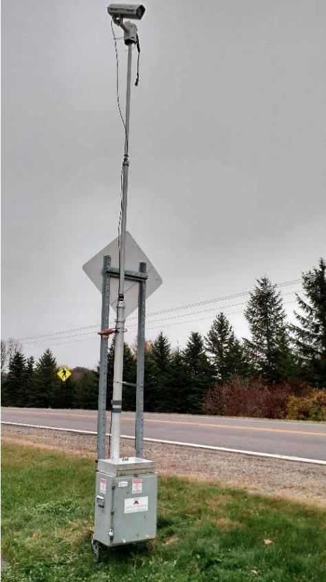
Researchers also collected extensive context information for each site, including number of lanes, lane width, bike and pedestrian facilities or networks, vegetation, motor vehicle speeds, lighting, pedestrian origins and destination, and the area’s population distribution.
Eleven to 20 hours of video recordings were collected and analyzed from the 10 study sites. Researchers and state, county and tribal members then met with tribal representatives to review and discuss the findings. Data was presented in diverse forms, including anecdotes, stories and the collected video evidence. Project members considered a wide range of potential countermeasures and possible funding to mitigate risk at problematic roadway sites.
Throughout the project, leaders from MnDOT’s Tribal Affairs office—Levi Brown, Edward Fairbanks and Adrien Carretero—were instrumental in guiding the project and facilitating the work on the ground needed to successfully reach its goals.
What Was the Result?
Video monitoring showed that among the 10 sites, 33 to 2,728 pedestrians were recorded crossing the roadways. The average number of crossings ranged from three to 137 people per day, while the maximum number of crossings ranged from eight to 210 people. Crossings with interactions with moving vehicles ranged from 9% to 65%.
Countermeasures were suggested for all sites except one, which is already controlled by a traffic signal. Possible remedies included crosswalks, signage, pedestrian crossing signs, pedestrian education, improved lighting, line of sight improvement, warning lights and access ramps.
“The results of this innovative study provide evidence and support for future implementation of countermeasures to mitigate risks for rural pedestrians crossing roadways on reservations,” said Hannah Pritchard, pedestrian and bicycle engineer, MnDOT Office of Transit and Active Transportation.
Researchers met jointly with tribal representatives, MnDOT district engineers and county engineers to finalize a shortlist of countermeasures and opportunities to integrate them into scheduled or planned projects.
The intensely collaborative character of this project was a potent force in its successes through its many steps. Researchers noted that rural transportation managers often lack data to support problem mitigation. This project’s combination of the tribes’ intimate knowledge of their pedestrian risks with robust and clear data showed that collaborative efforts can produce evidence that matters.
What’s Next?
Phase II of this project, already in progress, will complete field investigations and identify safety concerns at sites on at least four additional reservations. It will evaluate countermeasures installed at Phase I sites and evaluate new countermeasures determined through Phase II investigations. Because of the COVID-19 pandemic, data collection has been postponed until mid-2021, when pedestrians may resume their usual activities.
Related Links
- Research project page
- Research report
- HAWK Crosswalk Demo, Mille Lacs Band of Ojibwe
