

Researchers have developed a proof-of-concept curve speed warning system for use with mobile phones, a technology they hope car manufacturers might adopt for in-vehicle systems. The proof-of-concept system uses data from local road agencies on curve locations, speed limits and signage with geofencing to trigger cloud-based data alerts to road users driving faster than recommended speeds for curves.
What Was the Need?
Over one-quarter of fatal highway crashes occur at horizontal curves. In Minnesota, these areas are a contributing secondary factor in 49 percent of fatal crashes. Each year, accidents on two-lane, two-way highway curves injure over 4,000 people and result in 70 deaths, almost one-fifth of annual roadway fatalities in the state.
Research has shown that dynamic message signs with speed detection components work well in warning drivers to reduce speeds, but these systems require power supplies and cost approximately $14,000 per site. Minnesota’s Otter Tail County alone has over 400 reduced speed curve sites. The Local Road Research Board (LRRB) and MnDOT have been funding research that examines alternative approaches to speed warning systems for drivers approaching curves.
“This smartphone application stitches together existing technologies for GPS, GIS and mapping to provide an inexpensive, cloud-based warning system for drivers,” said Richard West, public works director, Otter Tail County.
In a 2015 study, researchers developed an in-vehicle, vibration-based warning system tested in a driving simulator that relies on data from highway sensors and other sources. Research in 2018 focused on the use of GPS signals to calculate and recalculate a vehicle’s trajectory on roadways to issue warnings. A new phase of this study is refining the approach to draw on vehicle-to-vehicle data.
What Was Our Goal?
The goal of this research was to develop a dynamic curve speed warning system that would employ cloud-based data sharing. The system would not require significant infrastructure investment and would be applicable to all reduced speed curves in the MnDOT highway system.
What Did We Do?
Following a literature search, researchers focused on developing a proof-of-concept smartphone app that would warn drivers of upcoming curves and speed reduction requirements. They also created a database for county road agency managers to input curve locations within their jurisdictions, speed limits and sign facing direction for use with the smartphone app.
Researchers layered the database into their geographic roadway inventory tool, which draws on GPS and mapping data, and combined data from the sources into a cloud-based curve database. Then they developed a geofence system that triggers alerts as the tracking device crosses virtual geographic boundaries.
A smartphone app uses GPS and GIS to trigger a warning via the cloud to smartphone users traveling above the curve speed limit as they pass through a geofence, or virtual geographic boundary, before the curve.
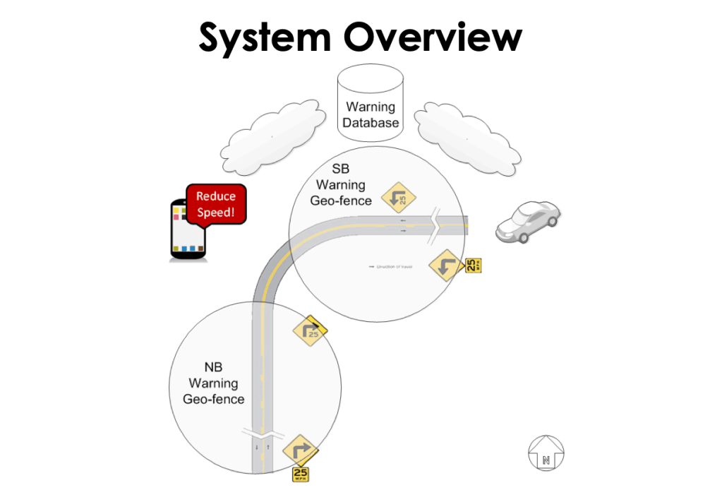
The curve speed warning system was tested on roadways in Otter Tail and Pope counties. After county agencies input curve location and speed limit data into the system, researchers tested the system by running the app while driving a number of highways selected for a high density of reduced speed curves. They adjusted the system based on these field tests to accommodate GPS signal speed, travel speed and cloud data transfer bandwidth.
Researchers then evaluated roadside dynamic speed warning system safety impacts to determine the potential safety and cost benefits from the cloud-based warning system.
What Did We Learn?
The curve speed warning system worked in proof of concept. GPS and cloud data can be drawn on fast enough to provide warnings in time for drivers to respond. Researchers refined geofencing parameters to only pull data for curves within 30 miles of the vehicle to keep data volumes to manageable levels within standard parameters for mobile phone data packages.
“Study results show that this system works accurately. If data from county and state roads were input, the application could be made available to everybody,” said Bradley Wentz, program director, Advanced Traffic Analysis Center, Upper Great Plains Transportation Institute, North Dakota State University.
The core of the system is the curve database, which requires accurate data input by county road agencies. Testing resulted in one performance error, which was traced to incorrect data for the facing direction of a warning sign.
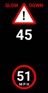
When vehicles are traveling faster than the speed limit for an upcoming curve, the smartphone app issues a silent, on-screen warning of the approaching curve and speed limit. If the vehicle does not slow its speed sufficiently, the app flashes and issues another warning with an audible signal.
The smartphone app sends a second warning with this message and an audible signal to a driver’s phone.
Safety implications may match crash and speed reductions identified in research on the safety benefits of dynamic sign warning systems. Researchers believe the cost to maintain the software and warning database roughly matches the cost to maintain a traditional dynamic speed warning sign system. But using a single cloud-based system for the entire roadway inventory offers a dramatic cost savings over installing expensive warning sign systems at every curve.
What’s Next?
Researchers have prepared presentations for local audiences and presented findings at the 2018 National Rural ITS Conference. County road agencies can easily update the database, and the system can accommodate not just reduced speed curve locations, but any reduced speed needs, such as seasonal bumps and cracks in pavement, work zones, special events and controlled intersections.
This post pertains to Report 2019-19, “Cloud-Based Dynamic Warning System,” published June 2019. For more information, visit the research project page.
