

Using an existing county road project as context, researchers examined the digital technologies and processes associated with civil integrated management (CIM). A comparison of CIM with the traditional methods used in the proposed county project demonstrated the advantages of CIM.
What Was the Need?
While the field of architecture has moved wholly into using digital technology for planning and construction, the majority of transportation agencies nationwide have not yet made the transition from paper-based to electronic workflow for infrastructure projects.
The Federal Highway Administration (FHWA) along with the American Association of State Highway and Transportation Officials, American Road and Transportation Builders Association and Associated General Contractors of America have been actively promoting the transition to e-construction, also known as civil integrated management (CIM), to everyone involved in highway construction. CIM allows agencies and other service providers involved in large infrastructure projects to work together using emerging digital technologies such as 3D modeling, lidar and electronic document management to deliver complex projects efficiently and safely.
“The transition from traditional methods to CIM will take focused dedication to make big changes throughout the state. However, it’s not a question of whether or not we make the transition, but when and how fast we can adopt and begin to benefit from the new technologies,” said Lyndon Robjent, county engineer, Carver County.
FHWA presents CIM as “the collection, organization and managed accessibility to accurate data and information related to a highway facility.” CIM is a powerful strategy usable in a wide range of project tasks, such as planning, environmental assessment, surveying and construction. By implementing CIM procedures, agencies that must do more with less can save time and money at every stage of a project.
CIM is a major technology shift that will require substantial time and capital investment in digital tools and specialized training. In a previous project, the Local Road Research Board (LRRB) sought to evaluate CIM options for local Minnesota agencies. Researchers continued that effort in the current project, demonstrating CIM processes and their benefits when applied to the early phases of an existing project in Carver County.
What Was Our Goal?
While the previous project focused on contractor requirements and construction needs, this project’s objective was to examine the application of CIM tools and procedures early in a project’s life cycle, from survey through 30 percent of design, using a traditionally delivered project as a pilot. A second objective was to develop guidance for agencies to take steps toward full transition to CIM and e-construction.
What Did We Do?
First, researchers developed a comprehensive presentation of the extensive project controls and project execution plans associated with building information modeling (BIM) that are necessary for infrastructure planning and construction using the full range of CIM digital technologies and procedures.
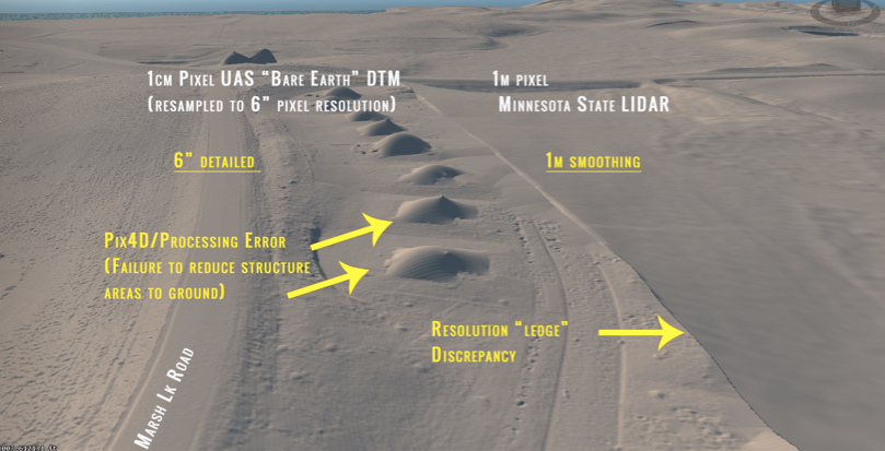
Then they applied CIM technologies and procedures to the initial portion of the Carver County Marsh Lake Road project, which was already funded using traditional methods. They explained how that project would have progressed using CIM. These steps included presentations of the following technologies and procedures:
- Emerging 3D survey (known as “reality capture”) techniques: Uses high-definition image capture through unmanned aerial vehicles (UAVs), as well as lidar. Multiple file formats allow data to be used for other needs.
- Integration of geographic information system (GIS) overlays into 3D: Processes GIS terrain and imagery by importing multiple images of the project site into design software to quickly create basemaps.
- 3D decision support for corridor optimization: Allows the design of optimum corridors to generate cost and traffic volume information quickly and compare more alternatives.
- Advanced 3D preliminary design for accelerated alternatives: Enables designers and engineers to examine many 3D road profile alternatives in a short time, requiring less time for optimizing profiles.
- Interoperability of data between design packages: Allows users to more easily move data from one design tool to another.
Finally, researchers developed key steps that Minnesota counties and cities could take to implement the best practices presented in this virtual pilot project and help promote agencies’ adoption and eventual full use of CIM.
What Did We Learn?
CIM technologies used in the preliminary phases of a project have the potential to deliver the most savings. The CIM tools allowed higher resolution survey tasks—reality capture—to be completed much faster, with higher resolution than traditional methods.
“The benefits of BIM for infrastructure rely upon connecting data and processes throughout all phases of a project. Preliminary design is a critical phase in this data life cycle that presents an opportunity to set the tone of success for a project,” said Chris Trboyevich, principal engineer, SRF Consulting Group, Inc.
Further, every other procedure described in the above tasks would also save time and money, and result in high-resolution products, some usable in more than one process. Researchers estimated that CIM tools and procedures would have facilitated faster decision-making due to visual processes: Approximately 40 working days would have been eliminated from the project through their use.
What’s Next?
Researchers identified 60 potential research areas for advancing early (0 percent to 30 percent) CIM design. They also presented programmatic next steps for agencies:
1. Start a small BIM practice with a dedicated design squad.
2. Start statewide BIM education and begin internal change efforts.
3. Establish an active framework to monitor progress.
4. Identify and begin pilot projects for BIM deployment.
This post pertains to Report 2019-36, “Life-Cycle Civil Integrated Management (CIM): Advancements in Preliminary Design BIM for Infrastructure,” published August 2019.
