

Snowplow operators work in difficult, often low-visibility conditions. A new system assists drivers in knowing their lane position and warns of approaching obstacles. After operators tested the system over two winters, researchers gathered feedback, revised the system and readied it for the next step in statewide deployment.
Challenging weather conditions can create stressful work environments for snowplow operators. Snow and ice may obscure pavement markings. Falling or blowing snow can impact visibility, making it difficult to keep the plow centered in the lane or identify upcoming obstacles. Additionally, operators must continuously monitor the snow and ice removal.
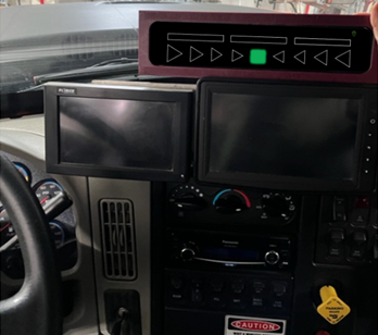
In 2018, researchers from the University of Minnesota Department of Mechanical Engineering affiliated with the Center for Transportation Studies developed a driver assist system to provide lane boundary guidance to plow operators when visibility is poor. The system uses high-accuracy vehicle location data from a global navigation satellite system combined with MnCORS (Minnesota Continuously Operating Reference Station) and high accuracy maps of the road to estimate and display relative lane position. Information about the plow’s position within the lane is displayed as a series of symbols on an in-cab screen.
“This system allows snowplow operators to stay in the lane where they couldn’t even see it before, resulting in safer and more efficient plowing in adverse conditions,” said Daniel Rowe, ITS project manager, MnDOT Office of Connected and Automated Vehicles.
The lane boundary guidance system was initially installed and tested on two trucks with support from the Local Road Research Board and MnDOT, allowing operators to navigate the plows when visibility was low. Operators responded positively, reporting that they felt safer and were able to clear a lane in one pass rather than two. Their feedback also identified several potential display improvements. To refine and test the new system, MnDOT worked with operators at multiple sites across the state to further identify opportunities for improvement and maximize benefits.
What Was Our Goal?
The aim of this project was to work with snowplow operators to improve the design of the driver assist system through field testing over two winter seasons.
What Did We Do?
In addition to the existing lane boundary guidance function, researchers developed and added a forward obstacle detection capability to the system. A radar mounted to the top of the snowplow’s cab identified hazards in the plow’s path, including their relative location and speed. Snowplow operators provided feedback on seven potential display designs, including audible warnings for hazard detection. Researchers created new designs in real time based on operator feedback. Then they integrated three of the most preferred designs into driving simulators for operators to test, with one design ultimately chosen for field testing.
After the hazard detection component was added and training materials were developed, three MnDOT trucks and one plow in Dakota County tested the updated system and display over the 2020-2021 season. On routes known to have blowing snow, researchers monitored weather conditions and alerted operators when sufficiently snowy conditions existed to test the system. Operators collected video and provided feedback in retrospective interviews, prompting display modifications that were again tested with operators through videos.
Feedback from the first field testing season prompted various system improvements, including display redesign, software improvements and efforts to increase hazard detection accuracy. Five additional snowplows tested the system during the 2021-2022 winter, allowing trucks in all MnDOT districts and Dakota County to participate in the study.
An online survey and virtual interviews with operators gathered final feedback on display and brightness options, overall user satisfaction and concerns with the revised system. Finally, along with updates to training materials, investigators collected data from plows with and without the system to compare lane position performance.
What Did We Learn?
A cycle of testing, operator feedback and redesign over two winter seasons yielded recommendations for a final design of the lane boundary guidance system. Operators were highly satisfied with the tool during low-visibility conditions, reporting decreases in stress, running off road and striking stalled vehicles. The tests confirmed that using the guidance system increased efficiency, with operators clearing lanes in fewer passes.
“The greatest value of this research is that operators love the guidance system we developed. One driver stated that ‘without the system, it would be almost impossible to do the job,’” said Max Donath, professor, University of Minnesota Department of Mechanical Engineering.
In the first testing season, operators reported the obstacle detection function was overly sensitive and generated false positives. Researchers changed the radar-mounting configurations and fine-tuned the detection algorithms. While obstacle detection improved in the second testing season, efforts to improve the hazard functionality will continue.
The GPS receivers deployed in the second phase were as highly accurate but more cost-effective than the units used in the first season. Operators experienced some issues with the reliability of the mapping functions, however, which will be addressed before further implementation.
A comparison of plow performance with and without the system showed some improvements in lane keeping and driving at slower speeds with the guidance system, though the number of variables such as roadway characteristics prevented broad generalizations.
What’s Next?
With an intention toward wide-scale deployment, MnDOT is already moving forward with an implementation project to explore production and operational support options for the guidance system. Additionally, investigators will refine the forward obstacle detection function and develop a procedure for MnDOT maintenance workers to create and maintain high-accuracy digital maps of snowplow routes necessary for the system’s operation.
